LITTLE VENICE, near Paddington in London, is a picturesque spot with a large body of water where three waterways meet. The waterways are the part of the Grand Union canal system that links London with Birmingham. Two of the canals that meet at Little Venice are the two sections of the Grand Union Paddington Branch that links Paddington with Brentford. The third is the Regent’s Canal that links Little Venice with Limehouse Basin next to the Thames, 1.6 miles east of Tower Bridge. The body of water where these three waterways meet is triangular with an island in it. The waterways enter the large expanse of water at each of its three corners.
While the area hardly resembles the Italian island of Venice apart from the presence of water, some believe it might have been given its name, Little Venice, by a former local resident, the poet Robert Browning (1812-1889). Others question this, and believe that it was Lord Byron (1788-1824), who associated the name ‘Venice’ with the area (https://hydeparknow.uk/2017/11/11/browning-never-dreamt-up-little-venice/). Apparently, Byron compared the dirtiness of the canals in Venice with those in Paddington:
“There would be nothing to make the canal of Venice more poetical than that of Paddington, were it not for its artificial adjuncts.”
Whatever the origin of its name, Little Venice is now a lovely oasis, favoured by tourists, locals, and waterfowl.
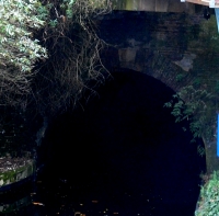
The Regent’s Canal leaves the Little Venice triangle of water by passing beneath the bridge carrying Warwick Road and heads northeast for 475 yards. It is flanked by Blomfield Road, lined with fabulous mansions, on its north side, and Maida Avenue on its south side. Then it enters a 243-yard-long tunnel that begins beneath a café on the Maida Vale section of Edgeware Road, which follows the route of the Roman road, Watling Street. The canal emerges from the tunnel a few yards north east of the eastern end of Aberdeen Street. This street, which has few if any outstanding architectural features, was once the home of the bomber pilot Guy Gibson (1918-1944) who was awarded a Victoria Cross; he was the Leader of the Dambusters Raid in 1943.
The tunnel through which the Regent’s Canal flows is called the ‘Maida Hill Tunnel’. The tunnel was constructed between 1812 and 1816. There are no towpaths in the tunnel, which is narrower than the open-air sections of the canal at either end of it. Therefore, horses could not be used to drag the barges through this subterranean section of the canal. Instead, the barges had to be ‘legged’. Men lay on their backs on planks on top of the barge, and using their raised legs, they pressed their feet against the roof of the tunnel, ‘walked’ them along it, and thus propelled the vessel through the tunnel. This was not without its dangers. For example, in 1825 the planks supporting three men, who were working their way along the roof of the tunnel, accidentally slipped off the top of the barge. One man was seriously injured and the other two were killed.
Much water has flowed through the tunnel since then. Today, pleasure barges, powered by engines, still pass through it. One day, when the pandemic eases up and the weather is better, we hope to take one of the popular cruises from Little Venice to Camden Lock via the Maida Hill Tunnel.
LONDON IS BLESSED with an abundance of open spaces where one can exercise and enjoy reasonably fresh air. In addition to parks, woods, the banks of the Thames, and squares with gardens, the towpaths alongside canals provide visually fascinating places to walk, run, or cycle. These canals used to be important routes along which freight could be transported right across England before they were rendered practically redundant by the advent of the railways. Despite this, they have been maintained and give great pleasure to many people including my wife and me.
Today, the 6th of November 2020, we walked along a branch of the Grand Union Canal from Golborne Road (near Portobello Road), where I practised dentistry from 1994 until about 2001, to Paddington Basin, which only became accessible to casual visitors in about 2000, when it was redeveloped. We began our walk in Meanwhile Park at the base of Trellick Tower, a tall block of flats designed in brutalist style by Ernő Goldfinger and opened in 1972. The pleasant community park, created in 1976, runs alongside a short stretch of the Paddington Arm of the Grand Union Canal, which was opened for use in 1801. We walked across the narrow park and onto the towpath. Although we have walked along this often, what attracted me this time in addition to the variety of barges and waterfowl was the variety of bridges that cross the canal and its towpath. I shall concentrate on these in this essay.
The first bridge we walked beneath is that carrying the Great Western Road over the canal. This is a cast-iron, single-arched bridge with the Union Tavern at its northern end. It looks like a Victorian design. Heading east, after walking beneath the sweeping curve of the Westway, an elevated motorway (the A40), the first bridge we encountered was that which carries the Harrow Road over the canal. This iron bridge with brick abutments is shorter than the previous one because the canal narrows temporarily as it passes beneath it. A few yards east of this, there is another bridge that crosses the canal to reach an old, derelict building that must have been a factory in the past. The bridge, known as the ‘Pipe Bridge’, has a roof and is completely enclosed with translucent panelling. It looks as if it was built in the last few decades and leads from the factory to a solid brick wall which serves as its abutment on the south bank of the canal.
Four hundred yards east of the Pipe Bridge, after passing the green space around the Church of St Mary Magdalene, we pass beneath a concrete footbridge with iron railings and decorative lamp posts that links Delamere Terrace and Lords Hill Road with Blomfield Road across the canal. The approach to the bridge from Delamere Terrace is an elegant helical ramp. This fairly modern crossing is known as the ‘Ha’Penny Bridge’ (i.e. half penny).
The towpath runs south east and alongside Delamere Terrace and reaches the building that houses the Canal and River Trust, the former Toll House. This is next to another bridge, a delicate-looking cast-iron structure with masonry abutments topped with distinctive lamp stands. This carries Westbourne Terrace Road (laid out in the early 1850s) over a constricted section of the canal. East of this the canal enters a vast triangular expanse of water, the junction of three waterways: the Paddington Branch from west London, its continuation towards Paddington Station, and the Regents Canal that leads to Camden Town and further east.
The poet Robert Browning, who lived near to this junction area, or possibly Lord Byron, is credited with christening this district as ‘Little Venice’, the name by which it is known today (https://londoncanals.uk/2010/01/17/the-history-of-the-place-name-known-as-little-venice-and-the-facts-that-are-ignored/). With its willow trees, colourful barges, a wealth of waterfowl, and some floating refreshment outlets, Little Venice is a popular place for tourists both local and from further afield. The small island in the middle of the watery space, inhabited only by birdlife, is called Browning’s Island.
We leave Little Venice by walking south east along the next section of the Paddington Branch canal. Soon, we reach another bridge, an undistinguished structure that carries the Harrow Road over us and another short, constricted section of the canal. The next 450 yards of the towpath on the west side of the canal has been redeveloped recently and is lined with eateries both on the shore and on boats moored alongside the shore.
After walking beneath a concrete bridge, the Westway Viaduct, carrying the Westway high above us, we soon reach a fascinating footbridge over the canal. The span across the water is approached by both curving staircases and spiral ramps. This suspension bridge is supported by cables fanning out from a tall pole on the eastern side of the canal. It is known as the ‘Harrow Road’ footbridge. Despite an extensive search of the Internet, I have not yet discovered who designed this structure, which is a visual delight in comparison with the next bridge we reach, an inelegant concrete span, which carries Bishops Bridge Road.
Shortly before the direction of the canal turns from south east to due east, we need to cross it over a curious looking modern footbridge that runs beneath what looks like a double wall of glass panels. This, the Station Bridge (Paddington Basin), leads from the east side of Paddington Station to a footpath leading to North Wharf Road. It was completed in 2004 by the Langlands and Bell partnership (www.langlandsandbell.com/work/).
Having crossed this distinctive bridge, we are now on the final stretch of this blind ending branch of the Paddington Arm of the canal. Next, we encounter another suspension footbridge with perforated metal panels along both sides of its footway over the water. This bridge leads to a car park next to a twentieth century block, part of St Mary’s Hospital. This is the Paddington Basin Footbridge designed by Sidell Gibson Architects.
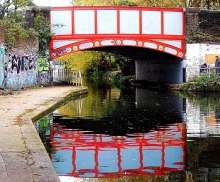
A few yards further east, we cross a short blind-ended inlet by means of a short bridge known as The Rolling Bridge. Designed by the Thomas Heatherwick Studio and completed in 2005, this bridge curls up into a circle to allow boats to enter or leave the inlet. Routinely, this pointlessly complex yet interesting bridge is opened briefly at noon on Wednesdays and Fridays and at 2pm on Saturdays.
On Fridays at noon, or when necessary, the last bridge over the Paddington Arm, a few feet away from its eastern terminus, can be seen in action. At rest, the Fan Bridge (aka Merchant Square Bridge) looks unexceptional. However, when it is raised to allow passage of vessels it is extraordinary. As the bridge rises, it splits into sections resembling five blades of a pen knife when they are all opened, or a lady’s fan. The bridge is twenty feet long, was designed by Knight Architects, and completed in 2014. We were lucky enough to see this bridge open and then to watch it closing. You can watch this happening on my video at https://youtu.be/UGQERbGo_jU .
Beyond the Fan Bridge, the canal ends abruptly. Trellick Tower, where we began our perambulation was a landmark in modern architecture when it was built. The Fan Bridge, constructed 42 years later, is another exciting development in design. In between the tower block and the unusual bridge, we passed beneath or over several canal crossings representing various points in the history of bridge design, many of them adding beauty to a lovely waterway that provides pleasure for many people.
THE RIVER WESTBOURNE may be known by few, but seen by many, living in, or visiting, London. Much of this tributary of the River Thames is hidden from view; it runs underground. The river rises in West Hampstead, passes through Kilburn and beneath Bayswater Road, flows through Kensington Gardens and Hyde Park, then runs into the Thames near the gardens of The Royal Hospital Chelsea, home of the annual Chelsea Flower Show, (close to the Bull Ring Gate bus stop).
Italian Gardens with 3 arched pump house and behind it on the right, the Queen Anne Alcove
What I will refer to as ‘The Serpentine’ is really the combination of the Long Water (in Kensington Gardens) and the contiguous Serpentine (in Hyde Park). It occupies part of the valley of the River Westbourne and is thus the only part of this river that most people can see. The Serpentine was created between 1730 and 1733 for Queen Caroline (1683-1737), wife of King George II. The body of water was formed by linking several existing ponds fed by the River Westbourne and by water pumped from the Thames. Today, some of the water is supplied from borewells in Hyde Park. Prior to the creation of the Serpentine, two of the ponds were separated by a building called ‘Price’s Lodge’. The “Daily Post” dated 20th of April 1733 reported that:
“The old Lodge in Hyde Park, together with part of the grove, is to be taken down in order to compleat the Serpentine River.”
Price’s Lodge, formerly known as ‘the Cheesecake House’ was a place where the nobility riding around Hyde Park could purchase refreshments (https://georgianera.wordpress.com/tag/prices-lodge/). The newspaper quoted above refers to ‘The old Lodge’, which might possibly been a separate building from Price’s Lodge, which might have still been in existence and being used as a boat house in 1801, but it was no longer standing later that century.
We begin our stroll at the end of the Serpentine just across Bayswater Road close to Lancaster Gate Underground Station. It was here that after flowing beneath Bayswater Road that the River Westbourne flowed into the Long Water section of the Serpentine. The so-called Italian Gardens consists of four large basins or reservoirs, each with eight sides. There is a fountain in the centre of each of them and another in the middle of them. The reservoirs are set on a platform adorned with sculptures and a statue of Edward Jenner, of vaccination fame. The platform is about eight feet above the water level of the rest of the Serpentine. At the north end of the platform with the reservoirs and fountains, there is a decorative building with a central single chimney and roofed with Italianate tiles. Facing the fountains, the building has a loggia, a convenient shelter during a rain shower. Behind the loggia there is a large room housing machinery to pump the water that shoots out of the fountains.
Between the Italian Gardens and Bayswater Road, there is a relatively new café, The Italian Gardens Café, which overlooks the fountains. The café is next to a neo-classical structure which contains a concavity lined with wood panelling. Made in 1705, designed by Christopher Wren (of St Pauls Cathedral fame) and bearing the crest of Queen Anne (reigned 1702-1714), this is the Queen Anne Alcove. This decorative building was moved to its present site from near Kensington Palace in 1868.
The four reservoirs, which make the Italian Gardens delightful, were built in 1861 and were intended to act as filter beds for the Serpentine. The loggia-cum-engine house was designed by Robert Richardson Banks (1812-1872) and Charles Barry (1823-1900). The sculptural features, including urns and nymphs, through which water flows from the Gardens into the Serpentine, were designed by John Thomas (1813-1862).
Moving on from the Italian Gardens southwards along the east side of the Long Water, you can, if you are lucky, spot birds such as herons and cormorants standing in the water near the opposite shore. After a short stretch along which the lake is well hidden from the path by vegetation you reach an open space in the centre of which there is a huge sculpture made of travertine stone, “The Arch”, presented to the park by its creator, Henry Moore (1898-1986), in 1980. Looking through the arch and across the Serpentine you can see the equestrian sculpture “Physical Energy” by the Victorian sculptor GF Watts. The two sculptures are in line with Kensington Palace, of which there is an unobstructed view from the Moore artwork. “The Arch” is irregularly shaped because it is based on the for of an animal bone that the sculptor had in his possession. A path leads away from the Serpentine to the Serpentine Sackler art gallery, which is often worth visiting. However, we will ignore that and continue to follow the Long Water in a south easterly direction.
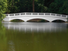
Soon, we reach an elegant masonry bridge with five arches spanning the water. This was built in the 1820s to the designs of John Rennie junior (1794-1874), son of John Rennie, who designed the first Waterloo Bridge. The foot path around the Serpentine passes under each end of the bridge through semi-circular stone lined tunnels. The bridge marks the boundary not only between Kensington Gardens and Hyde Park but also between the Long Water and the Serpentine.
Walking along what has become the north shore of the water because of the bend in the Serpentine, you will pass numerous waterfowl of various shapes and sizes, including swans, gulls, ducks, coots, moorhens, geese, and cormorants. Step carefully to avoid their squidgy droppings along the footway. As you approach the modernistic Serpentine Bar and Kitchen (designed as ‘The Dell’ by Patrick Gwynne [1913-2003] and built in 1964) at the eastern end of the lake, you will pass two boat houses and a shed where in normal times, small pedal-operated boats may be hired by visitors. Look away from these boat houses towards the parkland north of the water and you will spot a roughly hewn monumental stone, a granite boulder. This is the Norwegian War Memorial, presented by the Norwegian Navy and Merchant Fleet in 1978. On one side it bears the words:
“You gave us a safe haven in our common struggle for freedom and peace”,
and on another:
“Worked and shaped by forces of nature for thousands of years”, which refers to the stone itself.
The Serpentine Bar and Kitchen is at one end of the Serpentine. Walking around the back of it, you will notice a small monument that marks the spot from which a supply of water to the Abbey of Westminster was granted by King Edward the Confessor (reigned 1042-1066). Further along the path, heading south, we cross a balustraded bridge with arches facing the Serpentine. Water from the lake flows under the path and emerges from beneath it just before it falls over a cascade (made in 1820) into the luxuriantly vegetated ‘Dingley Dell’. South of the bridge, there is an ornamental urn, the Queen Caroline Memorial, beneath which there is the following inscription:
“To the memory of Queen Caroline wife of George II for whom the Long Water and the Serpentine were created between 1727 . 1731.”
The path around the Serpentine begins heading west along the south shore of the lake. It is flanked by many trees including weeping willows. Eventually, we reach the Lido. The Lido includes a café and an outdoor bathing area, where bold swimmers, who are not averse to pondweed and sharing the water with waterfowl, can swim in the unheated water of the Serpentine. The front of the café is supported by a row of pillars with Doric capitals. A plaque attached to the wall facing the water commemorates the once leader of the Labour Party George Lansbury (1859-1940), who created the bathing area in about 1930. When the situation is normal, when there is no covid19 pandemic, swimmers use the bathing area throughout the year whatever the temperature of the water.
After enjoying a refreshment at the Lido, we move towards Rennie’s mighty bridge, passing first the Diana Memorial Fountain, opened by the Princess’s mother-in-law, Queen Elizabeth II, in 2004. This curiously designed water feature consists of two streams of water that flow down curved slopes and meet each other at the lower end of the fountain closest to the Serpentine. Near this, there is a huge, rather unattractive, sculpture of a bird with a long beak. Titled “Isis”, this artwork was created by Simon Gudgeon in 2009. Its circular base has bands of metal inscribed with the names of supporters of the Look Out Hyde Park appeal.
A short stretch of foot path takes one from Isis to the beautiful bridge across the Serpentine. After emerging from the tunnel under the bridge, we find ourselves back in Kensington Gardens and alongside the Long Water section of the Serpentine, walking in a north-westerly direction. Looking away from the water, you will spot a single storey building with three arches each topped with triangular pediments. Built in 1734-35, this is Queen Caroline’s Temple, which might have been designed by William Kent (1685-1748). Opposite it and across the water you get a fine view of Henry Moore’s sculptural arch.
Further on, the pathway runs alongside the water, affording a good view of the distant Italian Gardens and many waterfowl perched on a series of wooden posts crossing the water. Looking away from the water, you will see a statue of Peter Pan standing above a collection of children and animals. Peter Pan is a character created by the author James Barrie (1860-1937), who lived on Bayswater. The statue was created in 1912 by the artist George Frampton (1860-1928).
A few yards further, and we come alongside the western edge of the Italian Gardens. Looking west, you can see a distant obelisk, a memorial to the explorer John Hanning Speke (1827-1864). Near the north west corner of the Gardens, there is a cute sculpture of two bears embracing each other. This metal artwork is placed upon a disused stone drinking fountain. A plaque attached to it notes that it commemorates the 80th anniversary of The Metropolitan Drinking Fountain & Cattle Trough Association, which was founded in 1859. If you get thirsty reading this plaque, then help is close at hand at the lovely Italian Gardens Café.
Finally, one more brief note about Queen Caroline, for whom the Serpentine was created, and which now provides much joy to many Londoners and others. When she inquired of Sir Robert Walpole (1676-1745) the cost of enclosing the publicly owned St James Park to secure it for her exclusive use, he replied:
“Only three crowns”
By this, Walpole, the Prime Minister, meant the Crowns of England, Scotland, and Ireland because what she was asking was politically impossible.
POSTBRIDGE IS A TINY SETTLEMENT in the middle of Dartmoor on the banks of the East Dart River, a tributary of the River Dart. The road that passes through the hamlet crosses the river over a venerable stone bridge (built in the 1720s). A few yards away from the bridge, there stands a far older bridge, a so-called ‘clapper bridge’.
The clapper bridge consists of four stone abutments (piers) spanned by three wide slabs of granite, each weighing about 6.5 to 8 tons. It is a simple but elegant structure, which has survived for many centuries. The bridge was most probably built to allow pack horses carrying tin to cross the stream on the way to Tavistock on the west side of Dartmoor. It was already in existence in the 13th century and is one of only 40 surviving examples of this kind of river crossing in the British Isles.
When we arrived at Postbridge during our journey from Cornwall to Somerset, the clapper bridge was crowded with camera-laden tourists who spoke German. Some of them were impolite, shouting at us rudely to get us to move off the clapper bridge so that they could get better photographs. Despite their uncultured behaviour, it was good to see that the bridge is still being used, albeit for leisure purposes. However, this is a far cry from what is depicted on a nearby pub sign: a horseman dressed in a red jacket riding his horse over the ancient bridge,
IT WAS HUNGER that drew us to Lighthorne, a tiny rural village just over six miles south-east of the city of Warwick. Our aim was to eat lunch at the highly recommended Antelope Inn before visiting the magnificent Compton Verney House with its gardens that were designed by Lancelot (‘Capability’) Brown in the 18th century.
Lighthorne is an attractive village nestling in a steep sided basin. Some newer buildings have been built on the slopes above what was the heart of the old village. The etymology of the village’s name is uncertain. Close to the Fosse way (a road built by the Romans; it linked Exeter with Lincoln in an almost straight line), it was in existence in 1086 when the Domesday Book was compiled. Throughout the centuries, the village has been ‘in the hands’ of various noblemen and religious institutions. Time constraints did not permit us to visit the village’s Church of St Lawrence, whose construction began in the late 14th century, but we hope to see it on a subsequent visit.
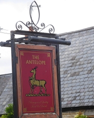
The Antelope Inn is housed in a building whose construction began in the early 18th century. The earliest record of the pub’s existence is a document dated 1838. This was signed by the then publican Joseph Lattimer. I was curious about the pub’s name because I thought that antelopes were not common in Warwickshire. The friendly staff in the inn suggested that there were two possible explanations for the name. One was that some previous owners of the pub had been a South African couple. Far more likely than this is the fact that the antelope is taken from the badge of the Warwickshire Regiment. A useful website, www.lighthornehistory.org.uk, explains the pub’s sign:
“The Antelope is standing on a strip of six pieces. This is said to be the six feet of turf representing the old name of the 6th Regiment of Foot.”
Always on the lookout for Indian connections, I found the following (www.forces-war-records.co.uk/units/316/royal-warwickshire-regiment):
“The Regiment took part in two campaigns in South Africa known as the Kaffir Wars (7th Kaffir War 1846-47 and 8th Kaffir War 1850-53), protecting Dutch and English settlers from the aggressive native tribes north of Cape Town. The Regiment also took part in the suppressing the India Rebellion of 1857.”
So, the regiment had taken part in campaigns both in South Africa, where my parents were born, and in India, where my wife was born. Regardless of the activities of the local regiment, we ate an excellent meal at The Antelope Inn.
More recently, in 1972, Ugandan Asians who had fled from Idi Amin’s Uganda were housed temporarily at Gaydon Airfield (now ‘Lighthorne Heath’) that is near Lighthorne (see: http://www.lighthornehistory.org.uk/wp-content/uploads/Shorthistory.pdf). Some of the inhabitants of Lighthorne assisted the distressed Asians during their first couple of months in England.
Almost opposite the inn, there is a well or spring that issues from an elaborate stone structure with a badly weathered coat-of-arms. It is a ‘broadwell’, a word derived from the Old English ‘breac-well’, a well that is supplied with water from a brook (rather than a spring). The well is likely to be as old as the village. However, the stone structure probably dates from 1746, as the Lighthorne history website notes:
“… the quoins and coving, were probably built in 1746, the remainder of the fascia, pool and paving are from the 19th and 20th centuries. The old ironstone escutcheon inserted in the fascia is older and is believed to be the arms of the Pope family, Lords of the Manor in the 16th and 17th centuries.”
There was green mildewed water in the two receptacles of the broadwell. It has been suggested that this well might have been used for washing in the past.
Close to the well, we spotted red grapes ripening on a vine growing on the side of a cottage facing the Antelope. They are located in what must be a fine sun trap. Our Sunday lunch in the inn, one of the best Sunday roast meals that I have eaten for many a year, ended soon before we were due to take up our timed entry at Compton Verney. Next time we visit the latter, spending more time in Lighthorne and The Antelope will be given top priority.
WHEN YOU LEAVE THE A38 road near Buckfastleigh and head southwards, you enter the Devonshire district of South Hams. This picturesque part of southwest England contains three towns that attract many visitors: Dartmouth, Kingsbridge, and Salcombe. Each is located on hilly terrain and has its own distinctive charms. All of them have steep streets that lead to places with great views.
Dartmouth, the home of an important large naval college, occupies a position on the estuary of the River Dart. Although it attracts many holidaymakers, it has the feel of a working town. The river is filled with boats, some used by pleasure seekers, and others (including ferry boats and fishing vessels) are working craft.
Salcombe, like Dartmouth, perches on the slopes of the shore of an inlet of the sea. Of the three places mentioned in this essay, it has to win first prize for its setting and attractiveness. I have visited Salcombe both in August (high season) and in May (before the season began). During the high season, the small town is flooded with holidaymakers, day-trippers and those staying in the place (including many owners of second homes). The streets are almost clogged with people. In contrast, when we visited it in May, the tiny town was delightful and relaxing.
We have just returned from staying in Kingsbridge, which is a few miles up the same inlet as Salcombe. This is, at first sight, the least obviously alluring of the three towns. Hence, it attracts fewer visitors than Dartmouth and Salcombe. However, as you wander around the small streets in the historic centre of the town, its charms reveal themselves to the viewer. The town is rich in buildings from the 18th and early 19th centuries. The Quay, where the tidal inlet meets the town is beautifully landscaped. Visitors tend to congregate here to enjoy paddle-boarding, boating (when the tide is high enough), crab fishing, eating ice cream,and just passing the time of day. Also, the town has several excellent restaurants. Of these, I would single out: The Old Bakery (for well-prepared Mediterranean and Middle-Eastern style food), the Dodbrook Arms (with first-class cod and chips as well as other perfectly prepared dishes), and Woodys, which serves very good locally reared beef. Like Dartmouth, but unlike Salcombe, Kingsbridge gives the feeling of being more than a holiday destination; it is a real working town.
In between the three towns, there are many villages and beaches worthy of exploration. Of the three places, Kingsbridge has become my favourite and we hope to return to it soon to use it as a base to get to better acquainted with South Hams.
KINGSBRIDGE IS A SMALL town in South Devon. It lies at the head of an inlet of a ria (a completely submerged river valley) upon which the better-known and more popular resort of Salcombe is also located.
Many histories of Kingsbridge relate that the town resulted from the union of two neighbouring settlements, the neighbouring royal estates of Alvington and Chillington. Kingsbridge was formed around a bridge (possibly, a draw-bridge) that connected the two at the head of the inlet of the ria. The bridge was built by the 10th century. So far, so good, but today there is no bridge in the town of Kingsbridge.
If you drive from Kingsbridge towards Dartmouth via the A379 road, you will soon arrive at the New Bridge west of the town. This not so new bridge with five arches was built in 1845 and restored several times since then. It crosses Bowcombe Creek, another branch of the ria. This bridge is not, and has never, ben inside the town of Kingsbridge; it is well outside it. It is not, as has been suggested to me by several locals, the bridge that gave the town its name. So, where was the bridge?
By chance, I found a book about the history of Kingsbridge on-line. It is “Kingsbridge and its Surroundings” by SP Fox, published in 1874. This is the only source that I have found so far that mentions the site of the bridge in Kingsbridge. On page 10, the author noted:
“Nearly at the lower end, Fore Street is crossed at angles by Mill Street and Duc’c [now called Duke] Street, the former on the west side, leading to West Alvington and Salcombe; the latter on the east, in the direction of Totnes and Dartmouth, and uniting the towns of Kingsbridge and Dodbrooke by a very small bridge.”
The old bridge mentioned by Fox no longer exists, but the two streets mentioned do. Duke Street, which used to run through from Fore Street to Church Street near to the present Duke of Prussia pub (according to a late 19th century map), is now a cul-de-sac on which you can now find the main entrance to a popular fish and chips shop called ‘The Cod Father’. Mill Street is still a road leading towards West Alvington and Salcombe.
Where Fox describes the bridge, there is no sign of a ditch or stream today. Maybe, long ago there might have been a ditch or stream across which the bridge straddled. At the head of the inlet of the ria in Kingsbridge, there is a small arch, which might be the outlet to a formerly visible stream, which has long since been covered.
“The exact site and function of the bridge is of great interest, as clear documentary evidence for an Anglo-Saxon bridge in Devon is rare (Henderson and Jervoise 1938, 29; Hoskins 1954, 147), and, in the present context, because the development and character of the town, like its name, can be expected to have been fundamentally linked with that of the bridge and its highway. The attraction and shaping of urban growth to main roads and river crossings is a strong pattern across medieval Devon (Slater 1999). The detailed map analysis for the urban survey indicates that the early bridge may have crossed the River – between routes later altered to become Love or Boon’s Lane on the west side, and Quay Street on the east – downstream from a tidal ford on the Mill Street-Duke Street route and below the extent of the medieval town…”
So, we cannot be certain of the location of the old bridge.
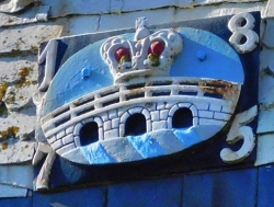
The coat of arms of Kingsbridge consists of a three-arched bridge surmounted by a royal crown. Whether or not the bridge had three arches is not at all certain, but the fact that it linked two royal estates justifies the presence of the crown. If the bridge was located where Fox believed, there was hardly enough width for a bridge with three arches.
But who was the king? It might well have been King Edgar, ‘The Peaceful’, who reigned from 959 to 975 AD. For, it was during his reign that a charter relating to boundaries dated 962 AD mentions the existence of a ‘king’s bridge’. That could also mean that the bridge was in existence before that king’s reign.
So, regardless of the actual position of the bridge after which Kingsbridge is named, we can be certain that the name is justified as there was a bridge somewhere in or near the town and it had royal connections. Whatever the origin of the name, the town of Kingsbridge is well worth a visit.
I BELIEVE THAT SOUND travels well over water. I do not know if that is scientifically proven, but I like to think that it is the case.
Yesterday, we visited Kenwood in north London. The neo-classical mansion, remodelled by Robert Adam (1728-1792) and completed in about 1780, contains a superb collection of fine art (the Iveagh Bequest), mostly paintings. Because of the Coronavirus pandemic, Kenwood House was closed, but its extensive grounds were open. Although the official car park was fully occupied, there was no sense of crowding in the grounds.
A wide terrace at the rear of the mansion overlooks a sweeping panorama including a lake at the bottom of the grassy slope that falls away from the terrace. From this vantage point, the viewer can see what looks like a fine bridge with balustrades and three arches at the eastern end of the body of water. However, what meets the eye is not a bridge, but a sham, a trompe-l’oeil, made in wood to produce a picturesque view. It was designed by Robert Adam and constructed in about 1767 and fully restored in the late 20th century.
The bridge has survived the progression of time, but another structure that was a notable feature on the side of the lake furthest from the House has not. This was an edifice shaped like the quarter of a sphere. Within this shelter, a whole symphony orchestra could be comfortably seated with their instruments. On summer evenings, orchestras used to play music that travelled across the lake to huge audieces seated on the grassy slope leading down to the water.
I used to attend these concerts occasionally during my younger days. They were, as I can recall, often on Saturday evenings. Two kinds of tickets were available. The costlier ones allowed a person to sit on one of the deckchairs arranged in rows on the part of the slope closest to the lake. The cheaper ones permitted holders to sit on the grass above the rows of deckchairs. Many people, who sat on the grass, brought rugs and picnics, which they enjoyed whilst listening to the music. I have never liked sitting on the floor and always preferred to experience the concert in a comfortable deckchair.
It was delightful sitting outside hearing well-performed music whilst the sun set slowly, and the twilight enveloped us all. The acoustics were good, but the first halves of many concerts were subject to the frequent the competition from noisy aeroplanes passing overhead. Usually, by the second half of the performance, there were few interruptions by ‘planes.
When we returned to Kenwood yesterday, the orchestra ‘dome’ was not visible. Where it had been has been replaced by bushes and trees. There is not a trace of it left. It looks as if it had never existed and I worried that maybe my memory had played a trick on me. We stopped a couple of elderly women and asked them about the concerts. They remembered them well and told us that they had been stopped a few years ago because, incredibly, local residents had complained about being disturbed by the noise (and increased traffic) during the few events that occurred each summer.
The lakeside concerts were held every year between 1951 and 2006, the year the English Heritage was forced to put an end to what had been a lovely annual event and an important money-spinner for them. I remember those concerts with fondness and hope that the wealthy inhabitants who live around the area, quite distant from the lake, will one day relent to allow music lovers to enjoy fine music wafting across the water. Well, as often is the case, money has more clout than culture.
THE GREAT BED of Ware is eleven feet long and ten feet wide. Constructed at the end of the 16th century, this four-poster bed dwarfs the modern king size bed (six and a half feet by five feet). The Great Bed was housed in various inns in the town of Ware in Hertfordshire until the early 1930s when it was acquired by the Victoria and Albert Museum in London. A few days ago, we visited Ware, not expecting to see its Great Bed but for other reasons. One of these was that it is a small town not far from Perry Green where the Henry Moore Foundation is located. Another was to see the upper reaches of the River Lea and the point along it where water enters the New River.
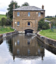
The Gauge House and the New River emerging from underneath it
The 42 mile long River Lea, a tributary of the River Thames, rises near Luton in the Chiltern Hills in Bedfordshire, flows through Hertfordshire, and then makes its way south through parts of northeast then eastern Greater London, reaching the Thames at Bow Creek. The river flows through the centre of Ware. A short walk (1.3 miles) along the bank of the river westwards from Ware, brings one to the start of the New River, which is not actually a river. It a canal built to bring fresh water from the clean upper reaches of the Lea into London.
The history of the New River involves the London district of Islington, where the reservoir that used to collect water from the New River was located. To quote from something I wrote a couple of years ago (https://londonadam.travellerspoint.com/44/):
“At the triangular Islington Green, Essex Road branches off from Upper Street at an acute angle. At the apex of the triangle, there is a statue of Sir Hugh Myddelton (1560-1631) sculpted by John Thomas (1813–1862). He stands bare-footed, wearing a ruff and breeches, which stop short of his uncovered knees and lower legs. Below his plinth, two carved children sit or kneel with pitchers between their legs. Once, they issued water, but no longer. Myddelton, a Welsh entrepreneur, was the driving force behind the creation of the New River water supply project. The 38-mile-long canal, which he helped to finance, was constructed between 1608 and 1613 …”
Roseberry Avenue in London’s Islington is now best-known for the Saddlers Wells Theatre. However, one of its near neighbours was of great importance in connection with the New River. Quoting from my piece again:
“Across Roseberry Avenue, which flanks Spa Fields, there is a large brick building with white stone trimmings, now a block of flats. Completed in 1920, New River Head House was designed by Herbert Austen Hall (1881-1968) as the headquarters of the Metropolitan Water Board. Above two of its windows, there are carved inscriptions. One reads “Erected MDCXIII”, and the other “MDCCLXXXII”. These dates are 1623 and 1782 respectively, which are carved in archaic lettering. The inscribed stones must have been saved from an earlier building. The land on which the house stands was formerly the ‘New River Head’.
The New River, a canal constructed to bring fresh water from Hertfordshire into London ended at the reservoir called ‘New River Head’. It was high enough above what was the city of London in the 17th century to allow the flow of water from it to be ‘powered’ by gravity alone (see: http://www.british-history.ac.uk/survey-london/vol47/pp165-184). The brick-lined reservoir was constructed in 1623, when the first building at the reservoir, the ‘Water House’, was also built. The architect Robert Mylne (1733-1811), surveyor to the New River Company, repaired, enlarged, and refaced it in the 18th century. The refacing was done in 1782 … The old building, which had been enlarged many times, was demolished by 1915.”
Having seen the site of the destination of water carried by the New River, I was keen to see the point of its origin. Hence, our visit to Ware.
We parked near the centre of Ware in a car park (Burgage Lane) next to a footbridge that crosses the Lea. Then, we followed the riverside path after traversing the river. At first the path runs sinuously beneath trees that line both banks the stream. Their different coloured leaves are reflected in the water that ripples as waterfowl swim past. We met many other people enjoying their morning walks, but the path was never crowded.
After a short distance, the river flows around and between a network of islands and the path loses its lining of trees. Soon, there is open country on one side and on the other a series of modern industrial buildings partially hidden from view by occasional trees including lovely weeping willows. We reached the impressive weir of Ware. To enable boats to pass this hazardous waterfall, a lock exists. Ware Lock was first built in 1855 but looks as if it has been modernised since then. Continuing west from the weir, we became aware of traffic noise as we approached the concrete bridge that carries the busy A10 dual-carriageway road over the river.
A third of a mile upstream from the road bridge, there is a tall brick house. It is not attractive and can be seen from afar in the flat landscape surrounding it. This building, The Gauge House, was built in 1856 to the design of William Chadwell Mylne (1781-1863), a son of Robert Mylne, who was involved with the terminal reservoir at New River Head in Islington (see above). The building is constructed on an arch, a bridge that straddles the start of the New River at the point where water enters the canal from the River Lea. The ground floor of the building houses a mechanism for regulating the flow of water from the Lea into the New River. This is explained on the historicengland.org.uk website as follows:
“… [The] ground floor contains the gauge which measures the intake of water from the River Lee; it consists of 2 iron boats 5m long floating at Lee level which are joined by a chordal segmental iron beam 9m long, and the rise and fall with the level of the Lee controls the flow of water over the sluice which can be further adjusted by weights hung from the gate, the daily intake from the Lee being 22 1/2 million gallons.”
Another website, engineering-timelines.com, gives details of the predecessors of the Gauge House:
“At first, the flow from the river was monitored by a wooden ‘balance engine’ – a rocking beam-and-float device. It was later replaced with the Marble Gauge, built by Robert Mylne inside a Portland stone chest. Though now empty, this is still visible a little downstream.”
We were able to see the exterior of the Gauge House including the grille through which water leaves the Lea to flow under the building and that from which it flows from the House into the first stretch of the New River. The canal flows about 300 yards south before making a right angle beyond which it begins flowing east. Having visited the London terminus of the New River and walked along attractive stretches of the canal lined by parkland in Canonbury, near Islington, I was very satisfied seeing where this historic waterway commences. We retraced our steps along the riverbank to Ware before driving to visit the Henry Moore Foundation at Perry Green.
Returning to the subject of beds, which is associated with the town of Ware, my mind leaps a quarter of the way around the world to Ootacamund (‘Ooty’) in the south Indian state of Tamil Nadu. In January 1994, we spent part of our honeymoon at St Margarets in Ooty, a guesthouse belonging to the ITC company. The room we occupied in this typical colonial style bungalow was huge. And it needed to be to accommodate the enormous bed that we occupied. This bed, whose width rivalled that of the Great Bed of Ware was not so long as the latter. Its sheets must have been specially made to fit this enormous bed. Although there were only two of us sleeping in it, I think that that it would have been wide enough for four or five couples to sleep in it without it becoming overcrowded.
Both Ooty and Ware have their charms, but the latter is far more accessible from London especially in these times of restricted travel caused by the wholly unwanted presence of the Covid-19 microbe.
THROUGHOUT THE ‘LOCKDOWN’, our wise leader, Mr Johnson, has encouraged us to take exercise, to get out and breathe some fresh air. And, we have been following that sound advice, walking in our neighbourhood anything from two to five miles every day. Since the ‘lockdown’ has been eased recently, we have been driving out of London far enough to escape from the hurly-burly of the city. Our latest excursion took us out westwards to a village on the River Thames called Hurley, which is upstream from the small town of Marlow. We chose our destination, the starting point for a riverside walk, almost randomly and had no idea what to expect when we arrived.
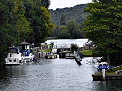
Temple Lock
Hurley is a gem of a village. A ford across the River Thames might well have existed at Hurley before the Norman Conquest of 1066. Many of the older buildings near the river and including the heavily restored Norman church formed part of a Benedictine priory that was established by Geoffrey de Mandeville, who died in about 1100 and was one of the richest men during the reign of William the Conqueror. His pious action at Hurley was strongly influenced by his second wife, Lescelina. The monastery was ‘dissolved’ during the great Dissolution of religious institutions carried out by Henry VIII, Some of the buildings including the priory’s cloisters have been picturesquely incorporated into newer buildings, most of which are used as dwellings.
A wooden bridge crosses a stream of the river to reach an island where Hurley Lock is located. We watched pleasure boats being lowered in the lock that allows ships to avoid the weir nearby. At the end of the island, another wooden bridge crosses back onto the right bank of the Thames. We walked beside the river, enjoying glimpses of it between trees whose branches dipped down towards the water. In addition to boats of all sizes from canoes to large cruisers and barges, the water is populated by ducks, andgeese. We also spotted plenty of insects that rest on the water’s surface and flit about hither and thither: water boatmen and pond skaters. Much of the path was flanked by deciduous woodland, mostly private property.
Another bridge, a long sweeping wooden structure took us to the left bank of the river. A short distance downstream from it, we reached Temple Lock. The river was so busy that boats had to queue up to wait for admission to the lock. With the river on our right and fields on our left, some with grazing cattle and sheep, we headed towards Marlow. The path was flanked by a profusion of wildflowers, many of them being ‘serviced’ by a rich variety of different kinds of insects. Before reaching Marlow, we had good views of Bisham Abbey across the river. The former Abbey was built in about 1260 as a manor house for the Knights Templar. Now, much of it remains, and is used as one of the UK’s National Sports Centres. Close by, the reflection of the tower of All Saints Church, Bisham, shimmers in the water of the river that flows close to its western end. The tower was built in the 12th century, and, later, in the 16th century other parts were added to the original church.
Soon after seeing Bisham’s church, the elegant suspension bridge across the Thames at Marlow came into view. The present bridge was built between 1829 and 1832 and designed by William Tierney Clark (1783-1852), who also designed Hammersmith Bridge. The famous Chain Bridge in Budapest (Széchenyi lánchíd), which is a larger version of Marlow Bridge, opened in 1849 was also designed by WT Clark. It was built by the Scottish engineer Adam Clark (1811-1866).
A slightly sensuous statue of a naked woman, apparently a nymph, can be seen near the Marlow Bridge. This early 20th century sculpture (1924) commemorates Charles Frohman (1856-1915), an American who was a famous theatrical manager who was drowned in the sinking of the Lusitania in May 1915. According to a notice next to the statue, it was erected on the spot from which Frohman used to enjoy watching the Thames. Apart from the bridge and the statue, there was little in Marlow’s High Street that attracted us, and we walked back to Hurley the way we came. On the way back, we caught good views of Harleyford Manor, a handsome Georgian home on a grassy rise overlooking the Thames. Designed by Robert Taylor (1714-1788) for its owner William Clayton (1718-1783), a Member of Parliament for Bletchingley and then Great Marlow, it remained in the Clayton family until 1950. Currently, this protected building houses offices.
We returned to Hurley, having had a hugely enjoyable stroll along the river and plenty of fresh air. We met numerous people along the way, all of them greeting us friendlily. Many of them had dogs, and almost all of them took care to maintain ‘social distancing’. We drove away from Hurley and about half an hour later we were caught up in the hurly burly of London traffic, which was moving at barely snail’s pace around the Hammersmith one-way system. Annoying as it was, it was worth enduring after having had such a wonderful day by the river, so far from the maddening crowds.