
Palms everywhere
Bikes and cows on the highway
Our Indian roads

Palms everywhere
Bikes and cows on the highway
Our Indian roads
I FIRST BECAME AWARE of fingerposts when I was in Ootacamund (‘Ooty’) in South India in 1994. One of the places in the spread out town is called Fingerpost because there is a fingerpost in the centre of the so named district.
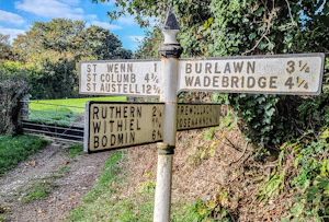
Where we are staying in Cornwall this October (2022) there is a finger post at a T-junction where one road meets another slightly larger one. The fingerpost at this junction ought to have three arms, one pointing along the road that ends here, and two for the larger road. However, the sign has four arms. One of them, pointing to Trewollack and Rosenannon appears to point where there is no road but the entrance to a farmer’s field without even a footpath crossing it.
This sign puzzled us for several days. Then, we spotted a small side road located about 100 yards downhill from the sign and the T-junction. This road leads to Trewollack and Rosenannon, but has no sign indicating this near where the lane begins. The four armed fingerpost is supposed to direct travellers along this road but is nowhere near enough to it to be helpful.
IN THE EIGHTEENTH century, travelling by road in England was not without its dangers, One of these was being robbed by highwaymen. Frequently, individual travellers and passengers in horse-drawn coaches were stopped by bandits, who were after money, jewellery, and other valuables.
Even close to London, for example between Mayfair and Hammersmith, highwaymen plied their evil trade. As an example, the diarist Samuel Pepys (1633-1703) recorded in his entry for the 19th of May 1669:
“Here news was first talked of Harry Killigrew’s being wounded in nine places last night by footmen in the highway, going from the park in a hackney coach toward Hammersmith to his house at Turnam greene [sic] …”
The punishment for highwaymen, who were captured, was often death by hanging. Many of those convicted of crimes in the countryside around London were hung at Tyburn, close to where London’s Marble Arch stands today. Ending a highwayman’s life at Tyburn was often not the end of the story as is shown in this extract from Select Trials, for Murders, Robberies, Rapes, Sodomy, Coining, Frauds, and Other Offences. At the Sessions-House in the Old-Bailey. …, (published in 1742):
“The same day that Hawkins and Simpson were hanged, their bodies were carried to Hounslow Heath, and there hanged in irons on a gibbet erected for that purpose, not far from that on which Benjamin Child was hanged in the same manner…”
Hounslow Heath was a vast area in Middlesex, now covered mostly by west London and Heathrow Airport. It was crossed by several important roads from London to the west and south west. In between the small villages that were dotted about the Heath, there was no shortage of highwaymen and the potential for stealing much of value was great on these major arteries. The quote above mentioned that the bodies of the two fellows who were hung at Tyburn were taken to Hounslow Heath to be hung in irons. Back in those times, the bodies of executed highwaymen were hung from gibbets alongside the main roads in order to deter others from being tempted to rob travellers. How effective these grim warnings were in preventing highway robberies, I do not know.

THE WESTERN END of Oxford Street is at Marble Arch. Beyond the latter, its continuation becomes Hyde Park Place and then, after 620 yards it becomes Bayswater Road, before reaching Notting Hill Gate, and then Holland Park Avenue. Oxford Street and its continuation westward follow the probable course of a road or track named by the Romans as Via Trinobantia. It ran from Colchester via London to Silchester (in Hampshire), which was a capital of the Atrebates tribe. According to Ralph Merrifield in his “Roman London” (published 1969), the Roman thoroughfare ran due west from Oxford Street, along what is now Bayswater Road to Notting Hill Gate. After that, it changed direction so that it headed directly to what is now Staines. Merrifield wrote that its course:
“… is closely followed by Holland Park Avenue and Goldhawk Road, until the latter turns sharply towards Chiswick. The Roman road is then followed by two lesser modern roads, Stamford Brook Road and Bath Road, and crossed Acton Green where it has been obliterated by the railways. Half a mile further west it is represented by Chiswick Road, which leads to Chiswick High Road…”
On a map drawn by Ralph Agas (c1540-1621) in the 16th century, the part of the Roman highway known now as Oxford Street was marked “The Waye to Uxbridge”. At that distant time (1561), the western edge of London was as far east as Farringdon, which follows part of the now lost Fleet River. This was the case except for riverside strip of buildings along the north bank of the Thames to Westminster. Oxford Street, so named in the 18th century, has had other names such as the ‘Tyburn Road’, ‘Uxbridge Road’, and ‘Oxford Road’.
A sign on a lamppost on Bayswater Road near to Lancaster Gate Underground station reads “A402 was A40”. The road running along the northern edge of Hyde Park and Kensington Gardens was designated in 1923 as ‘The London to Fishguard Trunk Road (A40)’. After the A40 was re-routed, part of it running along the elevated Westway (completed in 1970), the section of the original A40 (and much earlier the Roman road), which ran between Marble Arch and the westernmost end of Goldhawk Road was re-designated the A 402.
Until the early 19th century, what is now Bayswater Road and its western continuation ran through open country, passing Hyde Park, a royal hunting ground established by King Henry VIII in 1536 (and opened to the public in 1637). Before the park was established, the journey west of what is now marble Arch would have been through a rustic landscape and travellers would have been at risk from attacks by robbers, Today, the greatest risk faced by users of Bayswater Road is delay caused by traffic congestion.
NOTTING HILL GATE is a stretch of roadway, 670 yards long, that runs west from Bayswater Road to Holland Park Avenue. It is part of what was once a Roman Road that ran from London to places west and southwest of the city, passing through what is now Staines. The ‘gate’ in the street name refers to a tollgate that stood along it until about 1860. The gates of this barrier were placed so that there was no way of bypassing them via the few side roads that existed prior to the development of the area during the 19th century. I have no idea of how much was charged at this turnpike, but one might get a rough idea from a list of charges levied in early 18th century Wiltshire:
“1s. for a coach or wagon, 6d. for a cart, 1d. for a ridden or led horse, 10d. a score for cattle, and 5d. a score for sheep.” (www.british-history.ac.uk/vch/wilts/vol4/pp254-271).

I became curious to learn where the Notting Hill gate was located. I found the answer in a book that I bought whilst browsing the shelves of a local charity shop.
According to Florence Gladstone and Ashley Barker, authors of “Notting Hill in bygone days” (published in 1924), a detailed history of the area, the tollgate known as ‘Notting Hill Gate’:
“… was the first of three successive turnpikes at this spot and crossed the road east of the site of the Metropolitan Station. It seems possible that the toll-keeper’s house occupied the corner where that station is set back from the road. The very interesting view of this gate by Paul Sandby, R.A., dated 1793 … faces west and apparently shows the end of Portobello Lane and the Coach and Horses Inn.”
This gives a clear description of where the turnpike (tollgate) was located, but today, the appearance of the area described has changed considerably.
To begin with, Portobello Lane no longer exists, at least not with that name. It most likely followed the course of the present Portobello Road and connected with Notting Hill Gate along the southern stretch of what is now Pembridge Road. On a map surveyed in 1863-65, Portobello Road is marked in its present position but the northern stretch of it that led through what were then open fields to Portobello Farm was then still called ‘Portobello Lane’.
Today, the Underground station, formerly the ‘Metropolitan Station, is not visible on the road as it can only be accessed by staircases leading down from the pavements to a subterranean ticket hall. The platforms of the Circle and District Lines are housed in what was part of the original station, which is set back from the road. These platforms were opened in 1868 and were accessed through a building set back from the road as can be seen on an extremely detailed (1:1056) map surveyed in 1895.
During the 18th century, The Coach and Horses Inn stood at number 108 Notting Hill Gate, a few feet west of Pembridge Road (formerly ‘Portobello Lane’), where today a recently opened branch of Marks and Spencer is doing good business.
The tollgate disappeared long ago, and so did much of Notting Hill Gate that would have been recognisable to the two authors of the book mentioned above. The most prominent survivor of pre-WW2 days is the Coronet, currently the home of the Print Room theatre organisation. Near it but clothed in a dull, modern (1960s) exterior is The Gate Cinema, whose well-conserved auditorium was constructed in 1911 within a building that had been a restaurant since 1861 (https://historicengland.org.uk/listing/the-list/list-entry/1385016). Most of the rest of the architecture lining Notting Hill Gate is mostly 20th century and/or aesthetically unpleasing.
I am not sure that what preceded the buildings that we see today was necessarily much better aesthetically, but we can get an idea from a short stretch of buildings, currently numbered 26 to 70, opposite the northern end of Church Street. These are mostly shops, whose ground floors stretch away from the road to join buildings with two or three storeys set back from the road. Judging by the architecture of the buildings above and behind these shops, they were probably already built by the end of the 19th century. A drawing created in 1912 by William Cleverley Alexander (1840-1916), who resided near Notting Hill Gate, shows some of these buildings looking remarkably like how they appear today. However, since he created his picture, the row of buildings has been changed by the construction of two banks, each with a neo-classical façade.
While I would not recommend visiting Notting Hill Gate for its own sake, it is the gateway to far more attractive sights such as Portobello Road, Kensington Gardens, Holland Park, and Notting Hill of movie fame. And if you are thirsty, there are at least nine cafés within a paper cup’s throw away from the Underground station, and the number continues to increase.
EVERY SCHOOLDAY MORNING between 1965 and 1970, I boarded a single-decker, route 210 bus at Golders Green Station. First, we travelled up North End Road southwards to Jack Straws Castle, near Whitestone Pond. Then rounding the Hampstead war memorial, our direction changed from south to north-east as the bus travelled along the straight Spaniards Road, just a few yards more than half a mile in length. Invariably, the bus slowed down near the Spaniards Inn, where the road narrows because of the presence of a disused, historic tollhouse directly across the road from the inn. During my five years of travelling this route, I never wondered about the history of the Spaniards Inn, the tollhouse, and the area around them. Now, many years after leaving Highgate School, to which I was heading every morning on the 210, my interest in historical matters has been fired up, as has my desire to share that with anyone who has time to read what I write.

Spaniards Road and its eastern continuation beyond the tollhouse, Hampstead Lane, have long comprised an important route connecting Highgate and Hampstead. Spaniards Road, unlike Hampstead Lane, runs level without inclines or declivities. It runs along a ridge between the south and north facing slopes of Hampstead Heath. At its western end near the former Jack Straws Castle pub, it reaches the highest point in Hampstead, about 440 feet above sea level. At its eastern end by the Spaniards Inn, it is three feet lower. East of the inn, Hampstead Lane descends considerably and only begins to rise again within about three hundred yards of the centre of Highgate Village.
The tollhouse, the cause of an almost continuous traffic bottleneck, narrows the road width considerably so that it is only broad enough to admit one vehicle at a time. The tollhouse was built in the 18th century to collect tolls from those passing through the western entrance to the Estates of the Bishops of London, which they owned for almost 1400 years. Because of its tendency to slow the traffic, the idea of demolishing it or moving it a few yards from the road was mooted in the last century. The debate about shifting the tollhouse even reached the House of Lords, where on the 2nd of February 1966, Lord Lindgren (George Lindgren: 1900-1971) suggested:
“My Lords, to move this building two yards would, I think, be a tremendous waste of time, effort and labour. In actual fact, the lorries going by day by day remove the brick, and if we leave it long enough it will not be there.”
Luckily, the small building remains intact and although not particularly attractive, it adds to the charm of the area.
The Spaniards Inn, across the narrow stretch of road from the tollhouse, is believed to have been established in about 1585. It stands on the old boundary between Finchley and Hendon. Today, the Inn is in the Borough of Barnet and the tollhouse is in that of Camden. In former days, the inn marked the entrance to the Estates of the Bishops of London. The building that houses the inn is 17th century brickwork with some wooden weatherboarding, which is best viewed from the pub’s carpark. It is according to the historicengland.org.uk website:
“An altered building, but one that still has great character.”
The origin of the pub’s name is not known for certain. One suggestion is that the building was once owned by a family connected with the Spanish Embassy. Another is that at some stage, the house was taken by a Spaniard and converted to a house of entertainment. Edward Walford, writing in the 1880s, relates that whilst the Spanish Ambassador to King James I (ruler of England from 1603 to 1625) was residing there, he complained:
“…that he and his suite had not seen very much of the sun in England.”
The Spaniards Inn was the scene of an event during the Gordon Riots in mid-1780. The causes of the riots were several, but they included anti-Catholic sentiments following the passing of an act of Parliament passed in 1778, which ‘emancipated’ the Roman Catholics. At that time, Kenwood House, which is just east of the Spaniards Inn was one of the homes of William Murray, 1st Earl of Mansfield (1705-1793), an important lawyer, reformer (his reforms included objections to slavery), and politician. He was Lord Chief Justice when the act was passed and just prior to the outbreak of rioting, he had treated a Catholic priest leniently in a court of justice. A group of rioters attacked and burned Mansfield’s home in Bloomsbury Square:
“The furniture, his fine library of books, invaluable manuscripts, containing his lordship’s notes on every important law case for near forty years past … were by the hands of these Goths committed to the flames; Lord and Lady Mansfield with difficulty eluded their rage, by making their escape through a back door … So great was the vengeance with which they menaced him, that, if report may be credited, they had brought a rope with them to have executed him: and his preservation may be properly termed providential.”
So, wrote a correspondent in the “Lady’s Magazine” in 1780 (www.regencyhistory.net/2019/09/the-gordon-riots-of-1780.html).
Not happy with burning down Mansfield’s London home and its owner’s escape from their clutches, rioters set off towards Kenwood where they planned to destroy his rural retreat. They made their way to the Spaniards Inn, which was then kept by a publican called Giles Thomas. This shrewd fellow was quick to assess the reason for the rabble’s arrival and being a man of quick thinking, he opened his house and his cellars to the mob, offering them unlimited refreshment before they continued to undertake their planned work of devastating Kenwood House. As soon as they began enjoying Thomas’s generous hospitality, the canny publican sent a messenger to a local barracks to raise a detachment of the Horse Guards. At the same time, he arranged for other rabble-rousers to be supplied with liberal amounts of strong ale from the cellars of Kenwood House. A Mr William Wetherell, who was on the spot, encouraged the rioters to adjourn to the Spaniards Inn. By the time that the military arrived, the rioters were in no fit state to either resist the soldiers or to carry out their planned attack on Mansfield’s residence, which was a good thing not only for Mansfield but also for posterity because by 1780, the house had already been worked on by the architect Robert Adam, who had made improvements of great artistic value.
The Spaniards Inn stands amongst a cluster of historic buildings. Its next-door neighbour is a plain building, Erskine House (also once known as ‘Evergreen Hill’). This stands on the site of an earlier house of the same name built in about 1788. It was the home of the lawyer and Whig politician Thomas Erskine (1750-1823), Lord High Chancellor of Great Britain between 1806 and 1807. By all accounts, he was a brilliant man. He was involved in many important trials. One of these that attracted me because of my interest in Indian history was during the impeachment proceedings (in 1785) against Warren Hastings after his time as Governor General of Bengal. Mr Stockdale, a publisher in Piccadilly, issued a pamphlet by John Logan which defended Hastings, and following that was tried for libel expressed against the chief opponents of Hastings, Charles Fox and Edmund Burke. Stockdale was defended successfully by Erskine in a case that helped to pave the way to the passing of the Libel Act 1792, which:
“… laid down the principle that it is for the jury (who previously had only decided the question of publication) and not the judge to decide whether or not a publication is a libel.” (https://en.wikipedia.org/wiki/Thomas_Erskine,_1st_Baron_Erskine).
In addition to being involved in many other important cases, Erskine was an animal lover as well as a great wit. For example, when he saw a man on Hampstead Heath hitting his miserable-looking sickly horse violently, so Edward Walford recorded, he admonished the cruel fellow. The latter replied:
“Why, it’s my own; mayn’t I use it as I please?”
Hearing this, Erskine began beating the miscreant with his own stick. When the victim remonstrated and asked him to stop using his stick, Erskine, who could not suppress making a witty remark, said:
“Why, it’s my own; mayn’t I use it as I please?”
Erskine’s former home was located between the Spaniards Inn and a house, which still stands today, Heath End House, which was occupied by Sir William Parry (1790-1855), the Arctic explorer. The sign on its outer gate reads ‘Evergreen Hill’. Later, it was a home of Henrietta Barnett (1851-1936) and her husband Canon Samuel Barnett (1844-1913). Both were deeply involved with the creation of Hampstead Garden Suburb. Although I lived in the ‘highly desirable’ Suburb, I would have much preferred to have lived in the Barnett’s lovely house by the Spaniards Inn. Had I lived there in amongst that historic cluster of houses, maybe I would have walked to school instead of boarding the 210 bus in Golders Green.
KINGSBRIDGE IS A SMALL town in South Devon. It lies at the head of an inlet of a ria (a completely submerged river valley) upon which the better-known and more popular resort of Salcombe is also located.
Many histories of Kingsbridge relate that the town resulted from the union of two neighbouring settlements, the neighbouring royal estates of Alvington and Chillington. Kingsbridge was formed around a bridge (possibly, a draw-bridge) that connected the two at the head of the inlet of the ria. The bridge was built by the 10th century. So far, so good, but today there is no bridge in the town of Kingsbridge.
If you drive from Kingsbridge towards Dartmouth via the A379 road, you will soon arrive at the New Bridge west of the town. This not so new bridge with five arches was built in 1845 and restored several times since then. It crosses Bowcombe Creek, another branch of the ria. This bridge is not, and has never, ben inside the town of Kingsbridge; it is well outside it. It is not, as has been suggested to me by several locals, the bridge that gave the town its name. So, where was the bridge?
By chance, I found a book about the history of Kingsbridge on-line. It is “Kingsbridge and its Surroundings” by SP Fox, published in 1874. This is the only source that I have found so far that mentions the site of the bridge in Kingsbridge. On page 10, the author noted:
“Nearly at the lower end, Fore Street is crossed at angles by Mill Street and Duc’c [now called Duke] Street, the former on the west side, leading to West Alvington and Salcombe; the latter on the east, in the direction of Totnes and Dartmouth, and uniting the towns of Kingsbridge and Dodbrooke by a very small bridge.”
The old bridge mentioned by Fox no longer exists, but the two streets mentioned do. Duke Street, which used to run through from Fore Street to Church Street near to the present Duke of Prussia pub (according to a late 19th century map), is now a cul-de-sac on which you can now find the main entrance to a popular fish and chips shop called ‘The Cod Father’. Mill Street is still a road leading towards West Alvington and Salcombe.
Where Fox describes the bridge, there is no sign of a ditch or stream today. Maybe, long ago there might have been a ditch or stream across which the bridge straddled. At the head of the inlet of the ria in Kingsbridge, there is a small arch, which might be the outlet to a formerly visible stream, which has long since been covered.
To add some complexity to the story, a modern source (https://kingsbridge.gov.uk/wp-content/uploads/2020/01/B13-Kingsbridge_Devon-Historic-Market-and-Coastal-Towns-Survey-Report.pdf) suggested that the bridge after which the town was named was not within the town itself but some way outside it:
“The exact site and function of the bridge is of great interest, as clear documentary evidence for an Anglo-Saxon bridge in Devon is rare (Henderson and Jervoise 1938, 29; Hoskins 1954, 147), and, in the present context, because the development and character of the town, like its name, can be expected to have been fundamentally linked with that of the bridge and its highway. The attraction and shaping of urban growth to main roads and river crossings is a strong pattern across medieval Devon (Slater 1999). The detailed map analysis for the urban survey indicates that the early bridge may have crossed the River – between routes later altered to become Love or Boon’s Lane on the west side, and Quay Street on the east – downstream from a tidal ford on the Mill Street-Duke Street route and below the extent of the medieval town…”
So, we cannot be certain of the location of the old bridge.
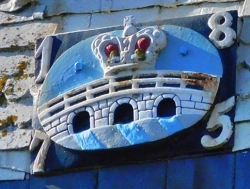
The coat of arms of Kingsbridge consists of a three-arched bridge surmounted by a royal crown. Whether or not the bridge had three arches is not at all certain, but the fact that it linked two royal estates justifies the presence of the crown. If the bridge was located where Fox believed, there was hardly enough width for a bridge with three arches.
But who was the king? It might well have been King Edgar, ‘The Peaceful’, who reigned from 959 to 975 AD. For, it was during his reign that a charter relating to boundaries dated 962 AD mentions the existence of a ‘king’s bridge’. That could also mean that the bridge was in existence before that king’s reign.
So, regardless of the actual position of the bridge after which Kingsbridge is named, we can be certain that the name is justified as there was a bridge somewhere in or near the town and it had royal connections. Whatever the origin of the name, the town of Kingsbridge is well worth a visit.
IT IS BECOMING AN ADDICTION: I must write something every day. It is probably a harmless compulsion, but it gives me great pleasure. Today, I will write about a road that did not exist until 1835. It runs northwards from the centre of London. It was built to bypass the hills on which Hampstead perches. The old route to Finchley and Hendon from central London passed across these hills before Finchley Road, originally a toll road, was constructed. Part of Finchley Road connects the suburb of Golders Green with Swiss Cottage. For five long years I travelled along this stretch.

Swiss Cottage is named after a pub, Ye Olde Swiss Cottage, which still resembles many people’s idea of what a Swiss chalet should look like. The pub is a descendant of the Swiss Tavern, built like a Swiss chalet. Opened in 1804, it stood on the same spot as its most recent avatar. It stood on the site near one of the toll booths built for collecting money from people using Finchley Road in earlier times.
There was another toll collecting place at Childs Hill, between Golders Green and Swiss Cottage. This toll gate was next to the now demolished Castle pub. For five years, I passed through Childs Hill on my way to the Hall School near Swiss Cottage.
I attended The Hall between 1960 and 1965. The Hall, founded in 1889 (the year the Eiffel Tower was built) was a private school for boys preparing boys for entry into private secondary schools, misleadingly called ‘public schools’.
During my time at the Hall, several bus routes plied between Golders Green and Swiss Cottage: 2, 2a, 2b, and 13. The fare was five pence (less than 2.5p) for children. I used to say to the conductor: “five-penny half, please”.
The bus journey to and from The Hall was tedious and slow. This was because Finchley Road was being widened. The roadworks began before I entered The Hall and continued after I left it five years later. To widen the road, which was lined by houses and shops all the way between Childs Hill and Swiss Cottage, every garden by the roadside had to be cut short. There was a garden centre in a long greenhouse near Finchley Road Underground station opposite the present O2 Centre. More than three quarters of its length was demolished to permit road widening. All in all, the long section of road being ‘improved’ caused the rush hour traffic to move sluggishly. After 5 years of enduring this, I used to be able to recite from memory and in the correct geographical order the names of all the shops along Finchley Road. Today, hardly any of them exist. Even the large, still extant department store John Barnes has changed its name to John Lewis. Gone is the remains of the garden centre and the Edwardian Swiss Cottage public swimming pool. During my time at The Hall, this place closed when the then new Swiss Cottage Library and swimming pools opened close to the swiss style pub. Another of many disappearances is that of Cosmo, a restaurant that used to be popular with refugees from Central Europe and later with my wife, who loved the Hungarian cherry soup served there.
The Camden Arts Centre stands at the corner of Arkwright Road and Finchley Road. The arts centre faces across the main road the start of Lymington Road, which soon runs along the side of a large grassy open space. This is where Hall School boys played football and cricket. We used to walk two by two with one of our teachers from the school to and from the field, a distance of at least a mile.
The Hall School was an ‘elite’ establishment. Almost all the pupils had parents who were listed in “Who’s Who”, or royalty, or were extremely wealthy. Several of my fellow pupils were sons of Greek shipping magnates. One of these used to be driven from the school to Lymington Road in his chauffeur driven Bentley, which he pronounced ‘bantly’. Occasionally, he used to offer teachers a lift in his luxurious vehicle.
The sports field in Lymington Road was opposite a small newsagent-cum-sweetshop. We were not supposed to enter this during school hours, which included time at the sports field. And, because we walked back to school after a sporting session, there was little chance to explore it, but somehow, we managed. The shop was amazingly well-stocked with cheap sweets. I discovered that if I walked from Swiss Cottage to Lymington Road, the fare from there to Golders Green was two pennies (there were 240 old pennies in one Pound) cheaper than from Swiss Cottage. This gave me two pennies on top of what I was given daily to buy snacks (in my case, read ‘sweets’) on the way home.
At Swiss Cottage, there was one sweet shop near my bus stop. It was a branch of Maynard’s inside the subterranean foyer of the Underground station. The sweets it sold were poor value: there was nothing for under three (old) pennies. In contrast, the shop on Lymington Road was full of sweets costing less than one (old) penny. For example, one penny bought four ‘blackjacks’ or a large chewy item called a ‘refresher’. And, for three pence, a ‘Sherbet Fountain’ (still available on the internet for 132 [old] pence or 55p). This used to consist of a paper cylinder containing a fizzy lemon flavoured white powder into which there was a black cylindrical straw made of liquorice (used to suck up the powder). The thing looked just like an unexploded firework. In short, It was worth walking about a mile to save on the bus fare and then to spend it in a place where my money had much better buying power.
At the end of the day, I disembarked at Golders Green near the Underground Station. There used to be many children from other schools mingling there on their journeys home. One incident at this place remains in my mind, but before relating it, you need to know what we wore at The Hall. The colour that predominated in the school uniform was pink, which was considered rather strange for a boys’ school. Blazers and peaked school caps also contained black trimmings. One of these, which was prominently sewn on to our caps and the outer breast pocket of our pink blazers trimmed with black, was a black Maltese cross. The way that the school’s emblem was drawn was closer to the shape of the German Iron Cross than to the real Maltese cross. By the time I was attending The Hall, I had already become interested in the Holocaust (the Shoah). Golders Green had many Jewish people living there and several shelves of its public library were filled with books about the deeds of Hitler and his followers. I borrowed and read many of them. Therefore, I was horrified when I stepped off the bus at Golders Green one afternoon, and then some schoolboys from another school shouted at my friend and me:
“Look, the Nazis have arrived.”
Is it not strange what one cannot forget?
Picture from https://www.uniform4kids.com/
.

ONE OF THE JOYS OF driving a car is that you can go wherever you wish. To get from A to B, you can either take the most direct route or find a more interesting one. We often opted for the latter.
We used to do driving holidays long before ‘satnavs’ and Google mapping were available to ordinary motorists. We relied on maps and atlases, always trying to find the most detailed available.
In Easter 1993, we sailed from Swansea in Wales to Cork in Eire. After a superb breakfast in Cork, which included some of the best black pudding I have ever eaten, we began driving towards Kilshannig near Castlegregory on County Kerry’s Dingle Peninsula.
Armed with a detailed Michelin road map and with a whole day ahead of us, we opted for a picturesque, but less direct, route.
Two interesting features of Irish roads soon became evident. First, there were bifurcations or t junctions where the same destination was on signs pointing in opposite directions. This was not a joke to confuse but simply an indication that both roads eventually met in the same place, maybe, for example, having skirted around different sides of a hill. The other thing is that we would be driving along a road and spotted a sign saying it was ‘5’ to the next village. Soon after that, another sign would inform us that it was ‘7’ to the same place, even though we knew for sure that we were going in the right direction. Ireland was busy converting its road signs from miles to kilometres, but many of the signs failed to include to which unit of measurement they referred.
We turned on our radio and listened to a programme in which someone was describing how to improve one’s skills when playing the game of curling. Every now and then, the presenter would say something like:
“Now, you hold it like this, see?”
The only problem was that there is nothing to be seen during a radio broadcast.
It was a lovely day and we were driving with the roof open. We drove past a golf course when suddenly there was a sharp clunk on the strip of roof between the car’s front windscreen and the open roof window. A poorly skilled golfer had made a poorly aimed shot. His ball had struck the car. Had it struck any where else, there was a good chance that it neither hit one of us nor shattered the windscreen.
Eventually, we reached Kenmare, having passed through Bantry Bay. Our most direct route would have been to go from Kenmare to Killarney via Muckross. However, my wife had discovered an alternative route on the map. It was marked on the map using the thinnest white line, which on Michelin msps denotes the most basic rustic thoroughfare. It was the road across a mountain pass called the Gap of Dunloe.
At first, the picturesque narrow road, not much wider than our Volvo saloon car, was easy to negotiate. We notice no other cars on it, but plenty of walkers and cyclists.
Soon, the track began to ascend, but not in a straight line. It wound up in a series of tight hairpin bends with very few passing places. After a while, we met a car coming down in the opposite direction. It was clear to me that my driving skills were better than the other. So, I had to reverse around several hairpin bends to reach a passing place.
We made it over the summit of the pass, and reached our hosts, Rober and Margaret at their cottage at Kilshannig, on a spit of land almost surrounded by sea and distant mountains: some of the beautiful scenery I have seen in Europe.
After welcome cups of tea, we told our hosts about our journey from Cork to Kilshannig. When we told them that we had driven across the Gap of Dunloe, Margaret exclaimed:
“But, that’s a footpath. We have often thought of visiting it, but we were worried that neither our Land Rover or our car would be able to cope with crossing the Gap.”
In August 2003, we went on a driving holiday in South Africa, concentrating on visiting places connected with my ancestors who began settling in the country during the nineteenth century. We also saw some places unconnected with my family history. Although the main roads in South Africa were excellent. However, some of the minor roads were adventurous to say the least.
My mother spent the first ten years of her life in a tiny town, Barkly East, in the Eastern Cape. We decided to drive there from Lady Grey, where we had been staying for a couple of nights. My grandfather, my mother’s father, was instrumental in getting the South African government to extend the railway across the mountains from Lady grey to Barkly East. Nelly, a barmaid at the Mountain View Hotel in Lady Grey, told us that the railway no longer ran. About 11 years before we met her, she went on this train along with many other children from Lady Grey on an excursion. Disaster struck. Someone who had had too much to drink took over the running of the train, and it went out of control. She remembers the train coming to a very sudden halt and being thrown forward. She was lucky only to have received ‘skid-marks’ on her skin: three of her young friends were killed instantly. It would have interesting to have travelled on that line, because like the Darjeeling Himalayan Railway in India’s West Bengal my grandfather’s railway negotiated the steep slopes of the mountains by a series of zig-zags with switchback reverses.
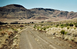
People at the hotel at Lady Grey said that instead of taking a new main road to Barkly East, we should go via the longer but far more picturesque via Joubert’s Pass. This was very scenic but quite hazardous. The road was no wider than our car and covered with loose gravel to which the car’s wheels could hardly grip. I would have enjoyed the spectacular views from the winding road on the way up had I not needed to concentrate so much on keeping the car attached to the road (‘track’ or ‘footpath’ would be a better description of the road). My heart sank when we saw a car approaching us from the opposite direction. The road was so narrow that one of us would have to reverse a long way. Fortunately, the occupants of the approaching car recognised us; they had met us at a barbecue party in Lady Grey on the night before. Kindly, and hazardously, they drove backwards at hair-raising speed along the winding road until they reached a passing place. After the summit of the pass, the road surface improved and we descended into farmland, deserted except for a few sheep and cows. The road wound around following a river, which lay at the bottom of a steep sided canyon. Eventually the road re-joined the main Lady Grey to Barkly East highway. In a way, this was our ‘baptism of fire’ as far as South African roads are concerned.
Later during our trip, we headed for Hogsback, a quaint place high in the Amathole Mountains about 40 miles northwest of King Williams Town, where my mother and her siblings were born. Some say that Hogsback was the inspiration for his “Lord of the Rings”. However, this is unlikely as Tolkien, who was born far away in Bloemfontein, left South Africa when he was three years old. Whatever the truth of this, we set out for Hogsback from Queenstown in the Eastern Cape. We drove via Whittlesea to the tiny village of Seymour.
My wife, our navigator discovered on the map that there was road – a shortcut, led from Seymour up the side of a mountain to Hogsback. On our detailed map, the thoroughfare was marked as “narrow but with tarmac, not for four-wheel drive vehicles alone”, which we interpreted as meaning that it was suitable for saloon cars such as our hired vehicle. We began driving along it through almost level farmland. We stopped to ask a local whether we were on the road to Hogsback. Somewhat drunkenly, the fellow pointed skywards, and said what sounded like:
“Herp, herp, herp.”
This we understood to mean that we had had to go ‘up, up, up’ the hill. Gradually the road began ascending, at first gently. A post-office van passed coming from the opposite direction passed us. This reassured us that the road was motorable. Soon, the road became amazingly steep.
This road, the so-called shortcut, proved to be the worst surface that I have ever driven on. Compared to it, Joubert’s Pass was a motorway. It got progressively worse as we painfully slowly approached Hogsback. The road had everything against it and us. There were potholes, and deep furrows where streams of water had eroded the gravel. Bare rock showed through the road and made steep steps that had to be carefully negotiated. Worst of all were large rounded boulders, which were difficult to drive around as the narrow road was bounded either by ditches or, more often, walls of rock. We were lucky that we neither capsized the car nor grounded it, nor damaged the sump or some other vulnerable part of its under-surface. Negotiating the car safely over some of these boulders reminded me of performing some of my trickiest difficult tooth extractions. In the dental situation, the operator has to avoid cutting the patient’s nerves or large blood vessels. On the way to Hogsback from Seymour, the driver has to avoit severing the fuel line that runs beneath the vehicle. One false move, and we would have been in big trouble, especially as on this lonely road there was neither a mobile telephone signal nor anyone else around. Hair-raising to say the least: I still shudder when I remember this journey. Things improved at the end of the road. We were amused to see a road sign at the Hogsback end of this road that advised: “Road not recommended for caravans”.
Later, when we returned to Cape Town, I was talking to a cousin about this road. He told me that he had driven along it but managed to ground the car on a rock and sever his car’s fuel line. I have no idea whether this awful road has been improved, but, even if it has, I will not tackle it again.
Hogsback was delightful. However, when we arrived snow began falling in a serious way. The temperature dropped. The cottage we had hired was freezing cold. One tiny heater was provided to try to warm the whole place. It was useless. Hogsback like large parts of India suffers from cold during winter months. Yet, in both places, proper heating seems to be considered unnecessary. Apart from being cold, we enjoyed our brief stay at Hogsback, where we were fed with well-prepared food in a restaurant near our accommodation, run by Dion and Shane.
The two journeys I have described were somewhat risky and adventurous. Writing this reminds me of the parting words of a librarian in, Philippolis (in the Free State), the birth town of Sir Laurence Van Der Post:
“Whatever we die of in South Africa, it won’t be boredom.”
Photo taken in 2003 on the Joubert Pass
