
A glass of cider
Chilling by the lazy river
It’s summer time

A glass of cider
Chilling by the lazy river
It’s summer time
THE GREAT ACTOR David Garrick (1717-1779) was famed for his many performances of plays by Shakespeare and many others. In 1754, he bought Hampton House (now Garrick’s Villa), which overlooks the Thames at Hampton. The following year, he decided to build a garden folly to honour his hero William Shakespeare. This was completed in 1756, and is now known as ‘Garrick’s Temple to Shakespeare.’ Its architect is unknown, but Garrick did employ Robert Adam (1728-1792) to make improvements to Hampton House, and Lancelot ‘Capability’ Brown (1716-1783) to landscape his grounds. Whether either of these two were involved in designing the Temple is not known.
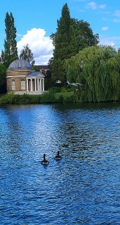
The octagonal Temple is Palladian neo-classical in style and has a portico with columns topped with Ionic capitals. Seen from across the Thames, it looks as if it had been plucked from a romantic painting of a classical Italian landscape by an artist such as Claude Lorrain. The Temple houses a statue of the Bard and a small museum about Garrick. Unfortunately, despite information on the Temple’s website which stated that it would be open, it was locked closed. We were not the only people to have arrived on a Sunday afternoon, expecting it to be open.
I am pleased that I saw the Temple, which I had read about, and plan to attempt to enter it on another occasion.

Laden with drums
He waits on the ferry boat
To cross the wide river
THE RIVER BRENT is a major tributary of London’s River Thames. It has two main sources: one, which feeds into Dollis Brook, is west of Barnet; the other, which feeds into Mutton Brook, is near East Finchley. As a child, Mutton Brook figured amongst the places where I used to play with my friends. It flows through Hampstead Garden Suburb (‘HGS’) where I lived during the first three decades of my life. In those far-off days, I had no idea that the then rather malodorous, winding Mutton Brook flowed into the Thames. Mutton and Dollis Brooks merge to become the Brent near Golders Green. The Brent flows through northwest and then west London to reach its junction with the Thames at Brenford, an interesting place, rich in history, described in my book “Beyond Marylebone and Mayfair: Exploring West London”.
On its way to the Thames, the Brent skirts another garden suburb, Brentham Garden Suburb (‘BGS’), which, like HGS, was an attempt to create a leafy residential Utopia. They were built at roughly the same time. The northern edge of BGS borders Pitshanger Park, through which the Brent winds its way towards the Thames. The name of the park derives from the Putelshanger or Pitshanger family, who occupied the area in the 13th century. The manor occupied the area between Hanger Hill and the Brent. Until 1908, when it was demolished, the manor house (and its antecedents), known as ‘Pitshanger farmhouse’, occupied a plot on the present Meadvale Road, which runs along the northern edge of BGS. This building was completely different to Pizhanger Manor near Ealing Broadway, which was built by John Soane (and is described in my book).
Pitshanger Park is laid out on what used to be part of the grounds of Pitshanger farmhouse. BGS was built on another part of that same estate. The park is adjacent to Ealing Golf Course. Both were already in existence by 1912. The Brent also runs through the golf course. While we were visiting the park, we watched two men leaning over the bank of the river, rather ineffectually attempting to recover a ball from the weeds growing beside the water.
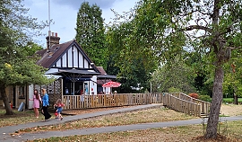
The park consists mainly of spacious grassy meadows that are bordered to the north by dense bushes and trees lining the bank of the Brent. Amenities offered in the park include, tennis courts, outdoor exercising equipment, and an attractive children’s play area. Housed in a small building with fake half-timbering, there is a small café with a terrace on which there are tables and chairs. The ‘caf’ offers hot and cold drinks and a few snacks. Its staff are pleasant, and the washrooms were clean.
While Pitshanger Park cannot be classed as one of London’s more exceptional open spaces, it is a wonderful amenity for residents in the area, just as was (and still is), the public gardens in HGS through which Mutton Brook flows.
THE FIRST DENTAL practice in which I worked was in the village of Rainham in north Kent. Although I practised there from 1982 until about 1994 and knew that there is another place called Rainham in east London, I never ever visited it. It was only in August 2022 that we drove to Rainham, formerly in Essex, and now in the London Borough of Havering. Situated between Dagenham and Tilbury, the former Essex village contains a few reminders of its past: several cottages; a fine old parish church; and Rainham Hall. It was to see the latter that we travelled through the industrial areas of east London to reach Rainham.

Rainham Hall, now beautifully maintained by the National Trust (‘NT’), was built in about 1729 by John Harle (1688-1742), who was buried in the nearby parish church. Son of a successful mariner of South Shields, who had made his fortune shipping coal from South Shields to London, John became a prosperous businessman in London. Harle came to Rainham (Essex) in 1728, and built the fine brick house, which we see today. As the NT’s guidebook pointed out:
“By aristocratic standards, the Hall is a modest house … The Hall is a rare survivor and a wonderful example of early 18th-century architecture. It was designed as a home, not for the super-rich, but for the ‘middling sort’ of successful marine merchant.”
Between Harle’s death and WW2, the Hall became the property of a series of different people, and occupied by many owners and tenants. During WW2 and until 1954, the Hall was requisitioned by Essex County Council, who used it for various purposes including as a nursery for the children of working women. The Hall was offered to the NT in 1945 and the organisation adopted it 4 years later.
Until the 1990s, the Hall had a series of tenants. Each of them had interests in arts and design. First, the place was leased to the architectural historian Walter Ison (died 1997) and his wife, the artist and architect Leonora Payne. In 1962, they left, and the Hall became home to Anthony Denney (1913-1990). Denney, who trained at the Royal College of Art in London was already an established fashionable fashion photographer and collector of modern art by the time he came to live in the Hall. He helped restore the house. After Denney left the house in 1969, it became home to the architect Adrian Sansom and his wife Marilyn, a cellist. In the 1980s, the Hall’s tenants were the viola player Paul Silverthorne and his wife Mary. They encouraged local residents to use the Hall’s extensive gardens and also did restoration work. Stefan Roman, the film-set designer and his family followed the Silverthornes, and the last tenants were the painter David Atack and his family.
The visitor to Rainham Hall can wander through rooms on the ground, first, and second floors. The various inhabitants of this large but intimate family dwelling have all made modifications to the building, but mostly in keeping with the age and character of the Hall. When we went around recently, many of the rooms were being used to house exhibits relating to the life and work of Anthony Denney. We entered the garden, which was in a sad state because of the lack of rain and the heatwaves affecting most of England. The recently restored stable block will be discussed in a future essay. I am glad that we visited Rainham in Havering. Although it cannot be described as being one of England’s most picturesque places, it is certainly more pleasing to the eye, and has more redeeming features, than Rainham in Kent.
WIDNES IN CHESHIRE is across the River Mersey from the town of Runcorn. In the past, both places were important industrial centres. Currently, they are linked by two impressive road bridges (the Mersey Gateway, opened in 2017; and the Silver Jubilee Bridge, opened in 1961 and given its present name in 1977) and a Victorian railway viaduct. The Silver Jubilee Bridge (‘SJB’) begins cross in the Mersey from Widnes near to St Mary’s church and the Victoria Gardens.
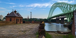
A few feet downstream from the SJB, there is what looks like a short jetty projecting a little way over the Mersey. On one side of this, there a small building with two separate slate roofs. The wide jetty-like structure looks disused. And so, it is. The structure is all that remains on the Widnes riverbank of the Widnes–Runcorn Transporter Bridge. Until 1905, when it was constructed, the only bridge across the Mersey at Widnes was the railway bridge (variously named as The Runcorn Railway Bridge, Ethelfleda Bridge, and Britannia Bridge), which was opened in 1868.
Between 1901 and 1905, when it was opened, the transporter bridge was under construction. It was the first of its kind in Britain. At each end of the bridge there was a 180 feet high steel tower. Suspended from them and spanning the length between them was a 1000-foot-long girder along which ran a continuous loop of cable. A transporter car was attached to the cable. The loop of cable was wound around a wheel attached to a winch on an engine housed in a building: the one which can be seen on the jetty-like structure at Widnes. As the wheel rotated, the cable moved, and the car attached to it moved across the river and high above it. The crossing took about 2 ½ minutes in favourable weather.
When it was built, the transporter bridge was cheaper to construct than a conventional bridge such as the one that replaced it in 1961 (i.e., the SJB). The transporter bridge, which was deemed inadequate for modern traffic volumes, was closed on the day that the SJB was opened, and it was demolished soon after. All that remains in Widnes is what can be seen at the end of Mersey Road next to the start of the SJB and Victoria Gardens. Although we did not visit Runcorn, I have read that the approach to the transporter bridge can be seen on that side of the river.
When we came across the remains of the transporter bridge, we had no idea what we were looking at. We asked several young people nearby, and they were unsure of its purpose. Older people whom we met in the nearby friendly pub (The Mersey), whose garden provides not only a pleasant place to drink but also a fine view of the SJB and the railway viaduct, were able to inform us about the bridge which is no more.
THE CRANE IS a tributary of the River Thames. Named after Cranford (Middlesex) through which it flows it is about 8 ½ miles in length. It rises as Yeading Brook and flows towards its mouth at Isleworth, just opposite the southern tip if Isleworth Ait. On its way, the Crane passes east of Heathrow Airport, Hounslow Heath, Whitton, Twickenham, and St Margarets. It also feeds the man-made Duke of Northumberland’s River, which enters the Thames about 610 yards downstream from the mouth of the Crane.

The Crane flows through beautiful, wooded parkland known as Crane Park. This incredibly peaceful open space, part of which is a nature reserve, is in Whitton near Twickenham. Part of the park is in the Borough of Richmond-on-Thames and the rest in the Borough of Hounslow. The Crane, which contains a wooded island and breaks up into rivulets occasionally, is bordered on both sides by the park. The island, Crane Park Island, now a lovely nature reserve, a peaceful oasis in a busy part of London, was created for a purpose that was far from peaceful: warfare.
In the 1760s, a gunpowder works was established in what is now the west part of Crane Park. The island was created to form a millstream for operating a waterwheel connected to a mill for grinding saltpetre (nitrates of either sodium, potassium, or calcium) used to make gunpowder. It was part of a complex of buildings that housed the Hounslow Powder Mills. Before the 19th century, what is now Crane Park would have been part of the then much vaster Hounslow Heath. The website of the Twickenham Museum noted that gunpowder mills were established on the Heath as early as during the reign of King Henry VIII.
All that remains of the Hounslow Powder Mills is a tall brick tower topped with a lead roof and a small lantern with a weathervane. It resembles a lighthouse. This was built either late in the 18th century or early in the 19th. Lying near it are a couple of circular millstones, which might have been used for grinding gunpowder. Described by some as a shot tower, it might have been used to manufacture lead shot. Molten lead would have been poured through a copper mesh near the top of the tower, and as it fell downwards, it formed into droplets, which when cooled became pellets of lead shot. This is most likely, but others suggest that the tower was part of a windmill.
Manufacturing gunpowder was a hazardous procedure, and unintended explosions were not unusual. The Twickenham Museum’s website related:
“Joseph Farington noted in his diary on Monday 25 January 1796 that: “The Powder Mills at Hounslow were blown yesterday. The concussion was so great as to break the windows in the town of Hounslow. Hoppner having been to Eaton, on his return rode to the spot where the Mills had stood, not a fragment of them remained. They were scattered over the country in small pieces. Three men were killed”… Burial records note deaths from further explosions: 5 on 17 November, 1 on 19 June 1798, 7 0n 15 July 1799, 2 on 27 June 1801, and so on through the century. Abraham Slade noted in his diary for 1859 that: “On the 29 of March the Powder Mills blew up, sending 7 poor souls into eternity in a moment. It has broken a great deal of glass in Twickenham & neighbourhood. We thought the whole place was coming down.””
The last major explosion at the Hounslow Mill was in 1915.
The powder mills passed through the hands of various operating companies: Edmund Hill, John Butts and Harvey and Grueber until 1820, then Curtis and Harvey until 1920, and then by Nobel Industries.The licence for producing explosives at Hounslow Powder Mill was revoked in 1927. In 1927, a Twickenham councillor, Frank Yates, bought the site. Later, he sold part of it for housing and the rest to Twickenham Council, who used it to create what is now Crane Park.
In addition to the impressive tower and a rusting sluice gate, several other less impressive remnants of the manufacturing complex can be seen on the island in the form of the bases of engine housings: lumps of bricks and concrete with thick metal rods protruding from them. Apart from the tower and a few other barely identifiable remnants, it is hard to believe that the sylvan and peaceful Crane Park was ever a place where the material of warfare had been produced for several centuries.
In the middle years of the 1720s, Daniel Defoe described Hammersmith as a village that was growing into a small town:
“… and some talk also of building a fine stone bridge over the Thames …”
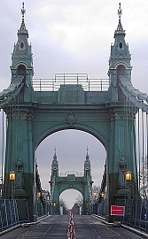
It was almost 100 years after Defoe speculated that a bridge across the Thames would be built at Hammersmith. A suspension bridge was constructed between 1824 and 1827. It was the first of this type of bridge to be constructed anywhere near London and the first to span the Thames. James Thorne, writing in 1876, that in outline and simplicity of style, it:
“… remains the best-looking-bridge of its kind on the Thames …”
The bridge was designed by William Tierney Clark (1783-1852), who had been guided in his development of bridge construction techniques by Thomas Telford and John Rennie, who designed the old London Bridge that now stands in Lake Havasu City in Arizona. Clark also designed the suspension bridge (1832) across the Thames at Marlow and the impressive Széchenyi (Chain) Bridge which crosses the River Danube to link Buda and Pest. The latter resembles Clark’s Hammersmith Bridge as depicted in old engravings.
In 1883-37, Clark’s Hammersmith Bridge was replaced by a newer one designed by Joseph Bazalgette (1819-1891). According to Cherry and Pevsner in The Buildings of England. London 2: South, Bazalgette:
“… re-used the piers and abutments. Iron-framed towers clad in cast iron partly gilt, with Frenchy pavilion tops, and elephantine ornament at the approaches … The deck stiffening girders were replaced in a major overhaul in 1973-6.”
This bridge, which was built for use by horses and carts, pedestrians, and the occasional cyclist, long before the advent of heavy motor vehicles such as busses and lorries. It has been closed for repairs several times, causing much nuisance for those who live on both sides of it. In April 2019, Hammersmith and Fulham Council closed the bridge to all motorised traffic. This was done following the discovery of serious cracks in the pedestals that support the bridge. It remained open for pedestrians and cyclists until August 2020, when a heatwave caused further deterioration. Then, the bridge was closed to all users.
A variety of schemes have been proposed for repairing the bridge and there was some disagreement as to who would pay for the work. In June 2021, Hammersmith and Fulham Council came to a cost-sharing deal to complete the rehabilitation of the Victorian bridge. In July 2021, the bridge was reopened for use by cyclists and pedestrians until 2027. In February 2022, I stepped on the bridge for the first time since it closed. The view from it is marvellous, especially upstream where one gets a good view of the historic buildings lining the waterfront between Hammersmith and Chiswick.

Arch-es over water
Suspend-ed by strong cables
It’s the Chelsea Bridge
ALMOST OPPOSITE THE modern and magnificent Hepworth Wakefield art gallery, completed in 2011, there is a nine arched bridge, built between 1342 and 1356, crossing the River Calder. Midway across the bridge, there is a small gothic chapel. It is the oldest one of only four surviving bridge chapels in England. Between the mid-14th century, when it was built and the Reformation in the 16th century, the Chantry Chapel of St Mary the Virgin served as a place of worship for travellers crossing the bridge on their way from Wakefield to Leeds.

The purpose of a chantry chapel was:
“…to provide for a priest to say mass for the souls of the dead to reduce their time in purgatory.” (www.wakefieldcathedral.org.uk/visit-us/the-chantry/a-history-of-the-chantry-chapel)
Two acts passed during the reigns of King Henry VIII and his successor the young and fanatically Protestant Edward VI resulted in the closure of the well over 2300 chantry chapels in their kingdom. The chapel on the bridge at Wakefield was one of them. Whereas many chantry chapels were demolished or otherwise rendered unrecognizable, that on the bridge at Wakefield survived because it is an integral part of the structure of the bridge (https://en.wikipedia.org/wiki/Chantry_Chapel_of_St_Mary_the_Virgin,_Wakefield).
The former chapel on the bridge was used for various purposes between 1547, when its religious use was terminated, and 1842, when it was restored. It was used at different times to house a warehouse, a library, an office, and a cheese shop.
In 1842, the formerly Roman Catholic chapel was transferred to the Church of England and it was restored by the Yorkshire Architectural Society, which was influenced in its philosophy by the Oxford Movement, a group of High Church members of the Church of England who wanted to reinstate older Christian traditions, which had been abolished during the Reformation, and incorporate them into Anglican theological practice. The architect George Gilbert Scott (1811-1878) was involved in the restoration of the edifice. By 1848, the bridge on the chapel was once again being used as a place of worship. For a while it became a parish church, and then after a new parish church was built in 1854, it became used for occasional rather than regular services, and peopled prayed whilst water flowed below them.
Currently, the chapel is under the care of the Friends of Wakefield Chantry Chapel, which was founded in 1991. The chapel is usually kept closed but is opened on certain days (see: www.chantrychapelwakefield.org/open-days.html). As luck would have it, we walked across the bridge on a sunny day that the chapel was open. The small chapel is on two floors. The upper chapel is well-lit both by electric lamps and light flooding through its five sets of stained-glass windows. A narrow spiral staircase leads down to a lower, poorly lit, rather dusty chamber, somewhat devoid of interest.
The decorative ancient gothic chapel on the bridge makes an interesting contrast to the elegant but puritanically unadorned exterior of the Hepworth Wakefield gallery almost opposite it. Both buildings are definitely well worth exploring.
