I HAVE BEEN to Calcutta (Kolkata) several times, and each visit I am impressed by the Howrah Bridge. It is a suspension type balanced cantilever bridge that carries pedestrians and road traffic across the Hooghly River, which is part of the mighty Ganges. This massive bridge contains 26,500 tons of steel riveted together – it contains no nuts and bolts. When it was opened for use in 1943, it was the world’s third largest cantilever bridge.
Before the present bridge was constructed, there was another bridge that crossed the Hooghly. Unlike the existing bridge, its roadway was close to the water. It was a pontoon bridge. Its roadway rested on floating pontoons. It had a section that could be opened to allow the passage of large vessels travelling along the Hooghly. The pontoon bridge was completed and ready for use in 1874. It served its purpose until the current bridge was opened in 1943.
The pontoon bridge
Recently, I obtained a book called “Wonderful India”. Inside its front cover, a former owner of the book had handwritten “LW Morris, Royal Air Force, Calcutta-July 1943”. The current bridge was opened in February 1943. The book does not contain a picture of that bridge, Instead, it contains a photograph of its predecessor, the pontoon bridge, with the caption:
“The famous pontoon bridge to Howrah, with the railway terminus in the background.”
I am guessing that had the new bridge been near completion when this book was compiled, it would have included this wonder of bridge engineering. As the book has no date of publication, the inclusion of the pontoon bridge rather than the suspension type cantilevered bridge, I feel that the book must have been compiled long before the new bridge was near completion, That the book includes a photograph of another bridge across the Hooghly: The Willingdon Bridge (also known as ‘Vivekananda Setu’). As this bridge (upstream from the Howrah Bridge) was completed in 1931, it would seem that “Wonderful India” was published sometime between 1931 and early 1943.
Crossing the Howrah Bridge as a pedestrian is a thrilling experience. One shares the footway with many other people. A large proportion of them are carrying loads on their heads, The water is far below one side of the footway, and the wide roadway is on the other. From the footway, one can see a huge flower market and several bathing ghats lining the riverbank. A steady stream of traffic flows across the bridge, including buses painted in many colours; ancient, yellow-painted Ambassador taxi cabs; hand-hauled carts; trucks; and other motor vehicles. And all of this crosses a stretch of the holy Ganges River. Although traversing the present Howrah Bridge is a memorably enjoyable event, which I am happy to repeat whenever I visit the city, crossing the former pontoon bridge must have been at least as exciting.
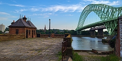
WIDNES IN CHESHIRE is across the River Mersey from the town of Runcorn. In the past, both places were important industrial centres. Currently, they are linked by two impressive road bridges (the Mersey Gateway, opened in 2017; and the Silver Jubilee Bridge, opened in 1961 and given its present name in 1977) and a Victorian railway viaduct. The Silver Jubilee Bridge (‘SJB’) begins cross in the Mersey from Widnes near to St Mary’s church and the Victoria Gardens.
A few feet downstream from the SJB, there is what looks like a short jetty projecting a little way over the Mersey. On one side of this, there a small building with two separate slate roofs. The wide jetty-like structure looks disused. And so, it is. The structure is all that remains on the Widnes riverbank of the Widnes–Runcorn Transporter Bridge. Until 1905, when it was constructed, the only bridge across the Mersey at Widnes was the railway bridge (variously named as The Runcorn Railway Bridge, Ethelfleda Bridge, and Britannia Bridge), which was opened in 1868.
Between 1901 and 1905, when it was opened, the transporter bridge was under construction. It was the first of its kind in Britain. At each end of the bridge there was a 180 feet high steel tower. Suspended from them and spanning the length between them was a 1000-foot-long girder along which ran a continuous loop of cable. A transporter car was attached to the cable. The loop of cable was wound around a wheel attached to a winch on an engine housed in a building: the one which can be seen on the jetty-like structure at Widnes. As the wheel rotated, the cable moved, and the car attached to it moved across the river and high above it. The crossing took about 2 ½ minutes in favourable weather.
When it was built, the transporter bridge was cheaper to construct than a conventional bridge such as the one that replaced it in 1961 (i.e., the SJB). The transporter bridge, which was deemed inadequate for modern traffic volumes, was closed on the day that the SJB was opened, and it was demolished soon after. All that remains in Widnes is what can be seen at the end of Mersey Road next to the start of the SJB and Victoria Gardens. Although we did not visit Runcorn, I have read that the approach to the transporter bridge can be seen on that side of the river.
When we came across the remains of the transporter bridge, we had no idea what we were looking at. We asked several young people nearby, and they were unsure of its purpose. Older people whom we met in the nearby friendly pub (The Mersey), whose garden provides not only a pleasant place to drink but also a fine view of the SJB and the railway viaduct, were able to inform us about the bridge which is no more.
BELIEVE IT OR NOT, busy Fulham in west London was a small country village in the early 19th century. Today, what was once the heart of the village, is the site of two bridges spanning the Thames. One carries the District Line railway tracks and pedestrians, and the other, an elegant stone bridge with five arches carries a road across the river. Known as Putney Bridge, the latter was completed in 1886 and designed by the prolific civil engineer Joseph Bazalgette.
Inside The Eight Bells in Fulham
Prior to the construction of the stone bridge, there was an earlier wooden bridge, known as ‘Fulham Bridge’. With roofed gatehouses at both ends and 26 arches (or openings), it was designed by Sir Jacob Acworth and completed in 1729. Its approach road was Fulham High Street. The bridge has long-since been demolished but a blind-ended, short inlet of the river, now named Swan Drawdock Nature Reserve runs right next to where the old bridge would have once begun.
The Eight Bells pub, which still serves customers, stands on Fulham High Street. Now housed in a Victorian building, it might have been first established as early as the 17th century. When the old bridge stood, it would have attracted much business from folk using the wooden crossing. Things changed when the new, current, bridge was constructed.
The approach to the new crossing, Putney Bridge, was not via Fulham High Street but by way of a new road, the present Putney Bridge Approach (the A 219), which does not pass the front of the Eight Bells. This led to a considerable loss of business for the pub, whose owners received £1000 in compensation: a great deal of money in the late 1880s.
The Eight Bells and its neighbour, a wonderful second-hand book shop, along with a few other shops near Putney Bridge station, although definitely not rural in appearance, retain a ‘villagey’ feel.
In the middle years of the 1720s, Daniel Defoe described Hammersmith as a village that was growing into a small town:
“… and some talk also of building a fine stone bridge over the Thames …”
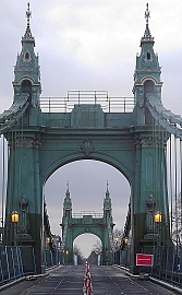
It was almost 100 years after Defoe speculated that a bridge across the Thames would be built at Hammersmith. A suspension bridge was constructed between 1824 and 1827. It was the first of this type of bridge to be constructed anywhere near London and the first to span the Thames. James Thorne, writing in 1876, that in outline and simplicity of style, it:
“… remains the best-looking-bridge of its kind on the Thames …”
The bridge was designed by William Tierney Clark (1783-1852), who had been guided in his development of bridge construction techniques by Thomas Telford and John Rennie, who designed the old London Bridge that now stands in Lake Havasu City in Arizona. Clark also designed the suspension bridge (1832) across the Thames at Marlow and the impressive Széchenyi (Chain) Bridge which crosses the River Danube to link Buda and Pest. The latter resembles Clark’s Hammersmith Bridge as depicted in old engravings.
In 1883-37, Clark’s Hammersmith Bridge was replaced by a newer one designed by Joseph Bazalgette (1819-1891). According to Cherry and Pevsner in The Buildings of England. London 2: South, Bazalgette:
“… re-used the piers and abutments. Iron-framed towers clad in cast iron partly gilt, with Frenchy pavilion tops, and elephantine ornament at the approaches … The deck stiffening girders were replaced in a major overhaul in 1973-6.”
This bridge, which was built for use by horses and carts, pedestrians, and the occasional cyclist, long before the advent of heavy motor vehicles such as busses and lorries. It has been closed for repairs several times, causing much nuisance for those who live on both sides of it. In April 2019, Hammersmith and Fulham Council closed the bridge to all motorised traffic. This was done following the discovery of serious cracks in the pedestals that support the bridge. It remained open for pedestrians and cyclists until August 2020, when a heatwave caused further deterioration. Then, the bridge was closed to all users.
A variety of schemes have been proposed for repairing the bridge and there was some disagreement as to who would pay for the work. In June 2021, Hammersmith and Fulham Council came to a cost-sharing deal to complete the rehabilitation of the Victorian bridge. In July 2021, the bridge was reopened for use by cyclists and pedestrians until 2027. In February 2022, I stepped on the bridge for the first time since it closed. The view from it is marvellous, especially upstream where one gets a good view of the historic buildings lining the waterfront between Hammersmith and Chiswick.
THERE IS A FASCINATING pair of railway viaducts at Chapel Milton, near Chapel-en-Frith in the Peak District. Constructed in about 1860 and then 1890, the viaducts support a place where two railway lines diverge. The viaducts, which join each other at a bifurcation were built at different times as the dates suggest. One of the arcades consists of 13 arches and the other of 13.
Allow Wikipedia to explain:”The Midland Railway opened a new line via Chapel-en-le-Frith Central and Great Rocks Dale, linking the Manchester, Buxton, Matlock and Midland Junction Railway with the Manchester, Sheffield and Lincolnshire Railway, in 1867, giving it an express through route for the first time between Manchester and London … The eastern section, essentially a second, mirror-image viaduct in an identical style, was added in 1890 to allow trains to travel between Sheffield and the south via Buxton and the Midland’s own line.” (https://en.wikipedia.org/wiki/Chapel_Milton_Viaduct)
THE GRAND UNION canal, constructed from the late 1790s onwards, is an important artery of England’s canal network. Beginning at Brentford on the River Thames, it winds its way to Braunston and Birmingham. Along its way it meets other canals, some of which are designated ‘arms’. For example, the Paddington Arm joins the main canal at Bulls Bridge in west London and from there it makes its way eastwards to Paddington. Recently, we visited friends, who live in Northamptonshire, and they took us on a walk along another arm of the Grand Union, the Northampton Arm. This branch of the main canal begins near Gayton and Blisworth and runs to nearby Northampton, where it enters the River Nene, which flows eastwards towards The Wash, an enormous inlet of the North Sea.
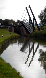
A swing bridge with a lock behind it
Much of the Northampton Arm is very narrow, just wide enough for passage of a single narrow boat. At regular intervals, the arm widens to allow vessels travelling in opposite directions to pass each other. Though short in length, only 4.6 miles, the Northampton Arm has seventeen separate, hand-operated locks for vessels to negotiate. The twelve of these, a flight of locks, is 1123 yards from the Gayton junction with the main canal. These twelve locks are along a stretch of canal only nine tenths of a mile long. The northernmost lock, that nearest towards Northampton, is a few yards north of a bridge carrying the M1 motorway. The locks carry the water from a bit over 300 feet above sea level nearest Gayton down to less than about 225 feet, each lock capable of lifting or lowering a vessel over 6 feet on average. Nearer Gayton, there is an old swing bridge, rather like a castle’s drawbridge. Looking at old maps, it appears that there were several more of these along the arm, but we only spotted one in the stretch between Gayton and the M1.
The canal and its associated towpath pass beneath the motorway through a giant concrete arch, paraboloid in shape and reinforced with horizontal concrete beams. Lined with graffiti, both conventional and anarchic artwork, walking under the motorway is an eery, rather science fictional experience. In contrast to this brutalist concrete arch, several lovely brick, hump-backed bridges carry minor roads over the Arm
“Almost immediately the Arm began to carry a large volume of merchandise and stayed busy for over 100 years through to after the First World War. In the post war years coal, grain and timber were supplemented by goods needed for the show industry such as strawboards for packing as well as iron ingots for castings. After World War II the carriage of goods ceased as road competition strengthened.”
Now, the Arm is used by intrepid canal boat owners, who are not averse to too much manipulation of lock gates. On the sunny Saturday afternoon that we visited the lock flight, we only saw one narrow boat attempting to negotiate the flight of twelve locks. In contrast, at Gayton Junction, the main Grand Union Canal, from which the Arm branches off, was full of pleasure-seekers’ narrow boats and other craft.
Though hardly used for freight these days, the canal system provides much pleasure to visitors both afloat and on shore. Wandering along the towpaths, one cannot fail to be amazed when considering the engineering ingenuity of the canal builders that we can still see today, as well as the work that is done to keep these waterways usable so many years after they were constructed.
BEFORE THE ADVENT of railways, transportation of goods across England (as well as Wales and Scotland) was heavily dependent on an extensive canal system constructed mostly in the 18th and early 19th centuries. Freight was carried along these canals in the holds of long narrow barges, more correctly known known as ‘narrow boats’. They had to be narrow enough to negotiate some of the narrower canals that formed part of the canal network. Prior to the development of steam and other kinds of engines, and even for some years after these became available, the narrow boats were towed by horses. These creatures walked along paths known as ‘towpaths’ that run along one or other side of a canal, except when a canal passed through a tunnel. In the tunnels there were no towpaths, and the boats were propelled by the feet of men lying either above the load on the boat or sometimes on planks projecting from the sides of the vessel, a process known as ‘legging’. The boatmen’s feet literally walked along the tunnel walls, thus moving the boat. Meanwhile, the towing horses walked over the hill through which the tunnel passed. All of this interesting but becomes even more so if you can experience a trip on a canal in a narrow boat.
Several companies offer canal trips between Little Venice (near London’s Paddington) and Camden Lock, east of it. We chose to travel on “Jason”, a narrow boat built in 1906 and one of the last of its era, which is still in use. “Jason” has been little modified compared to others that ply the route along the Regents Canal, a branch of the Grand Union Canal system. “Jason”, which was originally horse-drawn, has been fitted with a diesel engine that occupies part of the small rear located cabin that was once the home to a boatman and his family. Passengers sit in the long, narrow freight hold of the boat under an awning that was added when “Jason” was converted from a freight carrier to a tourist vessel, which has been doing the tours since 1951. Unlike most of the other tourist boats, there are no windows separating passengers from the exterior. This provides for great viewing along the route without the hindrance of sometimes not too clean glass, which might be encountered in other vessels.
The tour starts from a landing stage next to Blomfield Road, close to the cast-iron bridge that carries Westbourne Terrace Road over the Paddington Arm of the Grand Union Canal. At the other end of the trip, passengers disembark or embark next to the popular (not with me) and rather ‘tacky’ Camden Lock Market. The cruise between the two landing stages takes 45 minutes and is highly enjoyable. Travelling eastwards from Little Venice, we were given an extremely clear and intelligent commentary by a lady called Sarah. Various things she told us made a strong impression on me.
The Regents Canal that links Paddington Basin to Limehouse Basin in east London, where it leads to other canals, used to carry a wide range of goods, from coal to cocoa. The waterway passes under both rail and road bridges. Many of the latter have curved arches over the canal; are made of stone; and look older than the rail bridges, most of which have rectangular arches with roofs consisting of metal plates screwed together. Over the years, the tow ropes drawing the narrow boats have cut grooves or notches in the corners of the bridges next to the towpath. Some of the bridges have been protected from this damage by iron brackets placed so that the ropes passed over these instead of the masonry of the bridge. These metal protectors, which were easily replaceable, can now be seen to be notched where the ropes have abraded them.
“Jason”, like most other narrow boats, has a flat bottom and a shallow draught. This is because the water most of the canal system is quite shallow, usually not more than 6 feet deep. The bottom of “Jason” is made of wood (probably elm) and iron, a combination known as a ‘composite’ construction. Few narrow boats with this kind of construction exist today.
The most fascinating thing that Sarah told us related to the history of Lord’s Cricket Ground. In 1787, Thomas Lord (1755-1832), a professional cricket player, opened his first cricket ground in what is now Dorset Square (close to Baker Street Underground station). In 1809, Lord shifted his cricket ground to another location because the rent at his Dorset Square site became too high. The new location was on some disused ground just south of the present Lord’s Cricket Ground. It was where today the Regents Canal emerges from the eastern end of the 272-yard-long Maida Hill Tunnel. Let me explain.
In 1813, Parliament altered the route of the proposed Regents Canal so that it passed right through Mr Lord’s recently relocated cricket ground (www.lords.org/lords/our-history/timeline). Mr Lord was unhappy about this and was not prepared to give up his ground without first going to court. According to our guide, Lord struck a deal with the government. He agreed to move to a new site providing he was given all the earth that was excavated during the construction of the Maida Hill Tunnel. He used the vast amount of excavated earth to lay out the ground on which the present Lord’s Cricket pitches are now located.
Concerning construction, Sarah told us that not only had the tunnels been dug by hand, but also the entire canal system. Most of the manual workers were Irish and were known as ‘navigational engineers’, or ‘navvies’ for short. The base of the Regents Canal is lined with compressed clay to make it watertight, a difficult process when the canal was built.
The cruise between Little Venice and Camden passes through a variety of landscapes, ranging from disused industrial to almost bucolic. The canal passes through the northern edge of Regents Park, where it is lined with trees and parkland. In this stretch of the canal, it is difficult to believe one is in the middle of a huge metropolis and not in the deep countryside. The waterway also passes through the London Zoo. On one side, if you are lucky, you can catch glimpses of African hunting dogs and the occasional warthog in their cages overlooking the canal. Opposite them on the northern bank of the canal is Lord Snowdon’s aviary, now devoid of birds and awaiting a new purpose.
The 45-minute cruise provides an enchanting view of several districts of London. The commentary provided by Sarah and what she pointed out along the route helps recreate in one’s mind the golden age of canal transport. We enjoyed the cruise in both directions and hope that many others will take advantage of the special experience that it provides. For booking details and other practical information, consult “Jason’s” website: www.jasons.co.uk/the-tour
LONDON IS BLESSED with an abundance of open spaces where one can exercise and enjoy reasonably fresh air. In addition to parks, woods, the banks of the Thames, and squares with gardens, the towpaths alongside canals provide visually fascinating places to walk, run, or cycle. These canals used to be important routes along which freight could be transported right across England before they were rendered practically redundant by the advent of the railways. Despite this, they have been maintained and give great pleasure to many people including my wife and me.
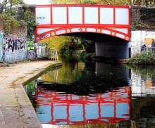
Today, the 6th of November 2020, we walked along a branch of the Grand Union Canal from Golborne Road (near Portobello Road), where I practised dentistry from 1994 until about 2001, to Paddington Basin, which only became accessible to casual visitors in about 2000, when it was redeveloped. We began our walk in Meanwhile Park at the base of Trellick Tower, a tall block of flats designed in brutalist style by Ernő Goldfinger and opened in 1972. The pleasant community park, created in 1976, runs alongside a short stretch of the Paddington Arm of the Grand Union Canal, which was opened for use in 1801. We walked across the narrow park and onto the towpath. Although we have walked along this often, what attracted me this time in addition to the variety of barges and waterfowl was the variety of bridges that cross the canal and its towpath. I shall concentrate on these in this essay.
The first bridge we walked beneath is that carrying the Great Western Road over the canal. This is a cast-iron, single-arched bridge with the Union Tavern at its northern end. It looks like a Victorian design. Heading east, after walking beneath the sweeping curve of the Westway, an elevated motorway (the A40), the first bridge we encountered was that which carries the Harrow Road over the canal. This iron bridge with brick abutments is shorter than the previous one because the canal narrows temporarily as it passes beneath it. A few yards east of this, there is another bridge that crosses the canal to reach an old, derelict building that must have been a factory in the past. The bridge, known as the ‘Pipe Bridge’, has a roof and is completely enclosed with translucent panelling. It looks as if it was built in the last few decades and leads from the factory to a solid brick wall which serves as its abutment on the south bank of the canal.
Four hundred yards east of the Pipe Bridge, after passing the green space around the Church of St Mary Magdalene, we pass beneath a concrete footbridge with iron railings and decorative lamp posts that links Delamere Terrace and Lords Hill Road with Blomfield Road across the canal. The approach to the bridge from Delamere Terrace is an elegant helical ramp. This fairly modern crossing is known as the ‘Ha’Penny Bridge’ (i.e. half penny).
The towpath runs south east and alongside Delamere Terrace and reaches the building that houses the Canal and River Trust, the former Toll House. This is next to another bridge, a delicate-looking cast-iron structure with masonry abutments topped with distinctive lamp stands. This carries Westbourne Terrace Road (laid out in the early 1850s) over a constricted section of the canal. East of this the canal enters a vast triangular expanse of water, the junction of three waterways: the Paddington Branch from west London, its continuation towards Paddington Station, and the Regents Canal that leads to Camden Town and further east.
The poet Robert Browning, who lived near to this junction area, or possibly Lord Byron, is credited with christening this district as ‘Little Venice’, the name by which it is known today (https://londoncanals.uk/2010/01/17/the-history-of-the-place-name-known-as-little-venice-and-the-facts-that-are-ignored/). With its willow trees, colourful barges, a wealth of waterfowl, and some floating refreshment outlets, Little Venice is a popular place for tourists both local and from further afield. The small island in the middle of the watery space, inhabited only by birdlife, is called Browning’s Island.
We leave Little Venice by walking south east along the next section of the Paddington Branch canal. Soon, we reach another bridge, an undistinguished structure that carries the Harrow Road over us and another short, constricted section of the canal. The next 450 yards of the towpath on the west side of the canal has been redeveloped recently and is lined with eateries both on the shore and on boats moored alongside the shore.
After walking beneath a concrete bridge, the Westway Viaduct, carrying the Westway high above us, we soon reach a fascinating footbridge over the canal. The span across the water is approached by both curving staircases and spiral ramps. This suspension bridge is supported by cables fanning out from a tall pole on the eastern side of the canal. It is known as the ‘Harrow Road’ footbridge. Despite an extensive search of the Internet, I have not yet discovered who designed this structure, which is a visual delight in comparison with the next bridge we reach, an inelegant concrete span, which carries Bishops Bridge Road.
Shortly before the direction of the canal turns from south east to due east, we need to cross it over a curious looking modern footbridge that runs beneath what looks like a double wall of glass panels. This, the Station Bridge (Paddington Basin), leads from the east side of Paddington Station to a footpath leading to North Wharf Road. It was completed in 2004 by the Langlands and Bell partnership (www.langlandsandbell.com/work/).
Having crossed this distinctive bridge, we are now on the final stretch of this blind ending branch of the Paddington Arm of the canal. Next, we encounter another suspension footbridge with perforated metal panels along both sides of its footway over the water. This bridge leads to a car park next to a twentieth century block, part of St Mary’s Hospital. This is the Paddington Basin Footbridge designed by Sidell Gibson Architects.
A few yards further east, we cross a short blind-ended inlet by means of a short bridge known as The Rolling Bridge. Designed by the Thomas Heatherwick Studio and completed in 2005, this bridge curls up into a circle to allow boats to enter or leave the inlet. Routinely, this pointlessly complex yet interesting bridge is opened briefly at noon on Wednesdays and Fridays and at 2pm on Saturdays.
On Fridays at noon, or when necessary, the last bridge over the Paddington Arm, a few feet away from its eastern terminus, can be seen in action. At rest, the Fan Bridge (aka Merchant Square Bridge) looks unexceptional. However, when it is raised to allow passage of vessels it is extraordinary. As the bridge rises, it splits into sections resembling five blades of a pen knife when they are all opened, or a lady’s fan. The bridge is twenty feet long, was designed by Knight Architects, and completed in 2014. We were lucky enough to see this bridge open and then to watch it closing. You can watch this happening on my video at https://youtu.be/UGQERbGo_jU .
Beyond the Fan Bridge, the canal ends abruptly. Trellick Tower, where we began our perambulation was a landmark in modern architecture when it was built. The Fan Bridge, constructed 42 years later, is another exciting development in design. In between the tower block and the unusual bridge, we passed beneath or over several canal crossings representing various points in the history of bridge design, many of them adding beauty to a lovely waterway that provides pleasure for many people.