
Not like a grape
Citrus and tasty it is
By Jove it’s a grapefruit

Not like a grape
Citrus and tasty it is
By Jove it’s a grapefruit

A cinema’s name
A metal of great value
It’s Palladium
WALKING BY THE THAMES along Chiswick Mall is always enjoyable whatever the weather. The landward side of the street is lined by houses, many of them well over 100 years old. One of them is called Said House. At first, I imagined that the ‘Said’ referred to someone or something in the Arab world, but it seems that this is not the case.
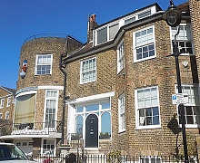
The façade of Said House is dominated by an overly large bay window with a vast single pane of curved glass. The building’s earliest structures date back to the 18th century, but much has been done since to distort its appearance. Pevsner said that the building was Victorian, but “georgianised” in about 1935 by Darcy Braddell (or by Albert Randall Wells [1877–1942]). One of its early inhabitants was an artist, Katherine Parsons. The actor and theatre manager Sir Nigel Playfair (1874-1935) was also one of its inhabitants. It was for him that the modifications, including the western wing with its bay window, were made.
The origin of the house’s name is uncertain, but one source suggests that it is so-called because its title deeds refer to “the said house”. This is the only explanation of the name that I can find having searched the Internet thoroughly.
There is a terracotta urn in an alcove high above the bow window. A passer-by with a strong Irish accent despite having lived in Chiswick for 65 years told me that this was something to do with Josiah Wedgwood (1730-1795). This might possibly be the case, but I cannot be certain about it. Wedgwood’s associate Thomas Bentley (1731-1780) did live in Chiswick. According to Lloyd Sanders in his “Old Kew, Chiswick and Kensington” (published 1910):
“Bentley was in failing health when, in 1777, he took up his residence at Chiswick, possibly to be near his friend, and three years afterwards he died. He was buried in Chiswick church, where Wedgwood raised a monument to his memory with a medallion portrait by Scheemakers.”
I have not yet discovered precise location of Bentley’s house. But that should not stop you from taking a stroll along Chiswick’s lovely Mall and enjoying the glorious display of flowers in bloom especially during spring and early summer.
AFTER A SUNNY DAY spent at Whitby in North Yorkshire, we stopped for a drink at sundown in a small pub for a pre-prandial alcoholic beverage. Behind and slightly above the pub, we could see a well-maintained 12th century parish church with later modifications and a square tower. Below the pub, a narrow stream, lined with bushes and trees, ran alongside the main road. Apart from the infrequent passing car, the place was silent except for some pleasant birdsong. From where we sat on the terrace of the hostelry, we could see a small, sloping village square with a simple war memorial, some parked cars, and a small post box. At first, I did not realise where we had stopped. Then, I noticed that the village is called Kilburn.

There is another Kilburn about 215 miles south of the lovely village where we stopped for an evening drink. The latter is in North Yorkshire and the place with the same name many miles south of it is in north London. Apart from sharing the same name, London’s Kilburn is anything but rustic and peaceful, as many Londoners will know. London’s Kilburn is not really picturesque in conventional people’s eyes; it might appeal to lovers of urban sprawl. It is a crowded metropolitan area with much commercial activity and a racial profile infinitely more diverse than that of the village in North Yorkshire.
I am not sure which of the two Kilburns is the oldest. North Yorkshire’s village was mentioned in the Domesday Book of 1086 and named ‘Chileburne’. London’s Kilburn was a settlement on an ancient Celtic route, a track between the places now known as St Albans and Canterbury. A priory was constructed on a stream that flowed through where London’s Kilburn now stands. The stream was known variously as ‘Cuneburna’, ‘Kelebourne’, and ‘Cyebourne’.
Whatever the origins of these two Kilburns, I know which of them is the place where I would prefer to linger in front of a glass of bitter.
KINGSBRIDGE IS A SMALL town in South Devon. It lies at the head of an inlet of a ria (a completely submerged river valley) upon which the better-known and more popular resort of Salcombe is also located.
Many histories of Kingsbridge relate that the town resulted from the union of two neighbouring settlements, the neighbouring royal estates of Alvington and Chillington. Kingsbridge was formed around a bridge (possibly, a draw-bridge) that connected the two at the head of the inlet of the ria. The bridge was built by the 10th century. So far, so good, but today there is no bridge in the town of Kingsbridge.
If you drive from Kingsbridge towards Dartmouth via the A379 road, you will soon arrive at the New Bridge west of the town. This not so new bridge with five arches was built in 1845 and restored several times since then. It crosses Bowcombe Creek, another branch of the ria. This bridge is not, and has never, ben inside the town of Kingsbridge; it is well outside it. It is not, as has been suggested to me by several locals, the bridge that gave the town its name. So, where was the bridge?
By chance, I found a book about the history of Kingsbridge on-line. It is “Kingsbridge and its Surroundings” by SP Fox, published in 1874. This is the only source that I have found so far that mentions the site of the bridge in Kingsbridge. On page 10, the author noted:
“Nearly at the lower end, Fore Street is crossed at angles by Mill Street and Duc’c [now called Duke] Street, the former on the west side, leading to West Alvington and Salcombe; the latter on the east, in the direction of Totnes and Dartmouth, and uniting the towns of Kingsbridge and Dodbrooke by a very small bridge.”
The old bridge mentioned by Fox no longer exists, but the two streets mentioned do. Duke Street, which used to run through from Fore Street to Church Street near to the present Duke of Prussia pub (according to a late 19th century map), is now a cul-de-sac on which you can now find the main entrance to a popular fish and chips shop called ‘The Cod Father’. Mill Street is still a road leading towards West Alvington and Salcombe.
Where Fox describes the bridge, there is no sign of a ditch or stream today. Maybe, long ago there might have been a ditch or stream across which the bridge straddled. At the head of the inlet of the ria in Kingsbridge, there is a small arch, which might be the outlet to a formerly visible stream, which has long since been covered.
To add some complexity to the story, a modern source (https://kingsbridge.gov.uk/wp-content/uploads/2020/01/B13-Kingsbridge_Devon-Historic-Market-and-Coastal-Towns-Survey-Report.pdf) suggested that the bridge after which the town was named was not within the town itself but some way outside it:
“The exact site and function of the bridge is of great interest, as clear documentary evidence for an Anglo-Saxon bridge in Devon is rare (Henderson and Jervoise 1938, 29; Hoskins 1954, 147), and, in the present context, because the development and character of the town, like its name, can be expected to have been fundamentally linked with that of the bridge and its highway. The attraction and shaping of urban growth to main roads and river crossings is a strong pattern across medieval Devon (Slater 1999). The detailed map analysis for the urban survey indicates that the early bridge may have crossed the River – between routes later altered to become Love or Boon’s Lane on the west side, and Quay Street on the east – downstream from a tidal ford on the Mill Street-Duke Street route and below the extent of the medieval town…”
So, we cannot be certain of the location of the old bridge.
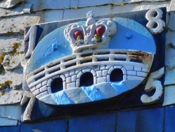
The coat of arms of Kingsbridge consists of a three-arched bridge surmounted by a royal crown. Whether or not the bridge had three arches is not at all certain, but the fact that it linked two royal estates justifies the presence of the crown. If the bridge was located where Fox believed, there was hardly enough width for a bridge with three arches.
But who was the king? It might well have been King Edgar, ‘The Peaceful’, who reigned from 959 to 975 AD. For, it was during his reign that a charter relating to boundaries dated 962 AD mentions the existence of a ‘king’s bridge’. That could also mean that the bridge was in existence before that king’s reign.
So, regardless of the actual position of the bridge after which Kingsbridge is named, we can be certain that the name is justified as there was a bridge somewhere in or near the town and it had royal connections. Whatever the origin of the name, the town of Kingsbridge is well worth a visit.
