WIDNES IN CHESHIRE is across the River Mersey from the town of Runcorn. In the past, both places were important industrial centres. Currently, they are linked by two impressive road bridges (the Mersey Gateway, opened in 2017; and the Silver Jubilee Bridge, opened in 1961 and given its present name in 1977) and a Victorian railway viaduct. The Silver Jubilee Bridge (‘SJB’) begins cross in the Mersey from Widnes near to St Mary’s church and the Victoria Gardens.
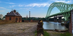
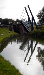
A few feet downstream from the SJB, there is what looks like a short jetty projecting a little way over the Mersey. On one side of this, there a small building with two separate slate roofs. The wide jetty-like structure looks disused. And so, it is. The structure is all that remains on the Widnes riverbank of the Widnes–Runcorn Transporter Bridge. Until 1905, when it was constructed, the only bridge across the Mersey at Widnes was the railway bridge (variously named as The Runcorn Railway Bridge, Ethelfleda Bridge, and Britannia Bridge), which was opened in 1868.
Between 1901 and 1905, when it was opened, the transporter bridge was under construction. It was the first of its kind in Britain. At each end of the bridge there was a 180 feet high steel tower. Suspended from them and spanning the length between them was a 1000-foot-long girder along which ran a continuous loop of cable. A transporter car was attached to the cable. The loop of cable was wound around a wheel attached to a winch on an engine housed in a building: the one which can be seen on the jetty-like structure at Widnes. As the wheel rotated, the cable moved, and the car attached to it moved across the river and high above it. The crossing took about 2 ½ minutes in favourable weather.
When it was built, the transporter bridge was cheaper to construct than a conventional bridge such as the one that replaced it in 1961 (i.e., the SJB). The transporter bridge, which was deemed inadequate for modern traffic volumes, was closed on the day that the SJB was opened, and it was demolished soon after. All that remains in Widnes is what can be seen at the end of Mersey Road next to the start of the SJB and Victoria Gardens. Although we did not visit Runcorn, I have read that the approach to the transporter bridge can be seen on that side of the river.
When we came across the remains of the transporter bridge, we had no idea what we were looking at. We asked several young people nearby, and they were unsure of its purpose. Older people whom we met in the nearby friendly pub (The Mersey), whose garden provides not only a pleasant place to drink but also a fine view of the SJB and the railway viaduct, were able to inform us about the bridge which is no more.
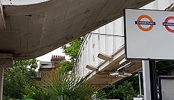
THE CONCRETE PEDESTRIAN bridge over the railway tracks at Kew Gardens Station cannot be described as attractive. In fact, it is rather ugly. However, on a recent visit to the station, I spotted a notice attached to the bridge that provides interesting information about it.
The bridge was opened in 1912. It is one of the earliest examples of the use of reinforced concrete in Britain. The technique used to construct this bridge was that pioneered by François Hennebique (1842-1921). The first building made in Britain using his method of reinforcing concrete with wrought iron beams was the Weaver Building in Swansea (in 1897). An article in Wikipedia related that between 1892 and 1902, over 2000 structures were made using Hennebique’s method. This makes me wonder why the plaque on the bridge at Kew is described as a “rare example” of this kind of structure. Maybe, what is meant is that it is a rare surviving example of his construction method. In any case, the bridge at Kew incorporates two features that were designed to protect users of the bridge from the smoke produced by steam engines that used to travel beneath it. One feature is the high wall on each side of the pathway over the bridge. The other are small projections over the railway lines, which were designed to deflect smoke from the bridge.
Kew Gardens station was opened in 1869. It is the only station on the London Underground network to have a pub attached to it. In the past, this pub, now known as The Tap on the Line, had an entrance directly from the London bound platform. In addition to the bridge described above, there is also an underground pedestrian passageway running beneath the tracks. The main reasons to use this station are to visit the National Archives and/or Kew Gardens. If you are coming from central London to visit the gardens, you will have to cross the tracks. So, why not cross them on a bridge that, although ugly, is a landmark of engineering history?
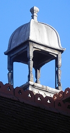
GROVE PLACE IS a short street running southwest from Hampstead’s steeply inclined Christchurch Hill. We often walk along it on our way to the lovely café at nearby Burgh House. A building containing numbers 29-31 Grove Place has often attracted my attention because its roof is topped with a couple of cupolas, each supported by four carved wooden pillars. These stand on either side of a grand central façade. The edifice bears a plaque, which is in an excellent state of preservation, that reads:
“This stone was laid by Mrs Sarah A Gotto on the 13th of July 1886 being the 50th Yr of the reign of her majesty Queen Victoria”
Elsewhere on the wall facing Grove Place there is a metal shield, painted black, which bears the following:
“1871. SPPM”
I was a bit puzzled by this because 1871 was some years before the stone was laid by Mrs Gotto.
I was pleased to discover that this building has been described in a book I possess, “The Streets of Hampstead” by Christopher Wade. He revealed that it was converted in 1970 from Bickersteth Hall, a hall built for the nearby Christ Church in 1895, and named after a former vicar, who later became the Bishop of Exeter. This gentleman was Edward Bickersteth (1825-1906), who had been vicar of Christ Church in Hampstead from 1855 to 1885 (www.praise.org.uk/hymnauthor/bickersteth-edward-henry/). Wade adds that it is confusing that the 1871 St Pancras shield and the 1886 Mrs Gotto plaque have been placed on the building. So, it seems that Mrs Gotto might have had little to do with laying the first brick of the building, but I wondered who she was.
Wade describes Sarah Gotto as Mrs Edward Gotto. Edward was most probably Edward Gotto (1822-1897), a civil engineer and architect who entered a partnership with Frederick Beesley in 1860 to create the engineering firm of Gotto and Beesley, which flourished for 30 years and carried out drainage works in towns all over the world including Rio de Janeiro, Seaford, Trowbridge, Evesham, Huyton and Roby, Redditch, Brentford and Cheshunt; and the drainage and water-supply of Campos (Brazil), Oswestry, Leominster and Cinderford (www.gracesguide.co.uk/Edward_Gotto). According to his obituary, Mr Gotto lived in Hampstead in a house called The Logs on East Heath Road. Built in 1868, The Logs, was as I have described elsewhere (see https://adam-yamey-writes.com/2021/02/01/finding-boy-george-and-bliss-in-north-london/), much later home to the comedian Marty Feldman and the singer Boy George. Edward’s wife Sarah was born Sarah Ann Porter (1829-1901; https://ancestors.familysearch.org/en/L1Q6-7NL/major-harold-ralph-gotto-1868-1957), She and Edward had eight children, one of whom was Harold Ralph Gotto. He was born in 1868 in Hampstead and later became a major in the British Army.
All of this is interesting enough, but none of it explains (to me) why Sarah is commemorated by the plaque on the house in Grove Place. If anyone knows the reason, I would be pleased to hear from them.
NEEDING BREAKFAST ON our way from Warwick to visit Baddesley Clinton House, we chose to stop at the Hatton Locks Café, which we had noticed on our road map. What we did not know is that the café is located next to the uppermost of a flight (or series) of 21 canal locks. The locks are situated on a stretch of the Grand Union Canal that was, when it opened in 1799, the Warwick and Birmingham Canal, which was built to carry locally mined coal for use in power stations and nearby factories (https://canalrivertrust.org.uk/enjoy-the-waterways/canal-history/history-features-and-articles/the-history-of-hatton-locks). It became an important transportation link between London and The Midlands.
The 21 locks are spread along an almost 2 mile stretch of the canal and the towpath along this section of the waterway is popular with cyclists, walkers, and their dogs. Some of the locks are narrow. They were built when the canal was first constructed. Other locks on the flight are far wider. They were built in 1932 and allow two craft to use the lock simultaneously. The newer locks were built at a time when the canal system began to have to compete with motorised road and rail transport.
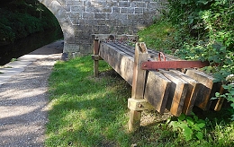
The café is about 310 yards northwest of a small car park and is reached by walking along the towpath. Near the café, there are some unusual looking tables and benches made of old timber. Most of the timber pieces are planks with a short semi-circular projection at one end. These wooden piles used to be driven into the floor of the canal between parallel wooden blocks that held them straight upright against the walls of the waterway. Their purpose was to prevent the banks of the canal from being eroded by the water flowing past them. Nowadays, they have been replaced by coir matting that serves the same purpose because it is considered to be more eco-friendly that timber. The wooden piles were driven into place by a mechanised hammer system aboard a motorised boat that plied along the canal. One of these boats, now disused, has been preserved near the café.
The locks on the Hatton Flight looked different from the many other canal locks we have seen on our travels around the country. Each lock is flanked by what looks like a pair of tall, stout candles. These things house the mechanisms that control the flow of water into the locks and are operated by canal users equipped with a special handle or windlass that fits onto a projection that is linked to the gearing that operates the valve.
The Hatton Locks Café is a real treat, both visually and gastronomically. Both inside and outside, it is decorated with a profusion of objects, some folkloric, some whimsical, and others related to the life and traditions on the canal. A team of friendly workers produce simple but excellently prepared English breakfast items as well as very acceptable coffees. So good was our breakfast that we made a detour to return to this place on the following morning. Most of the clientele seemed to be locals, many of whom were on friendly terms with the staff. Although we had only been once before on a busy morning, the staff remembered exactly what we ate and drank on the day before. When we are next nearby, we shall certainly visit this wonderful establishment again. On our next visit, we will join the other walkers and stroll past all the 21 locks.
EVERY NOW AND THEN, a canal needs repairing. For example, it might have sprung a leak either in its retaining walls or in its clay bottom. In such circumstances and no doubt others, the repair work can only be carried out if the canal is emptied of water, a tall order in a canal that might be many miles in length. Recently, we were walking along the towpath of the Macclesfield Canal, which links Marples Lock on the Peak Forest Canal with Hardings Wood Junction on the Trent and Mersey Canal, when we spotted something that we had never noticed before whilst walking along a canal towpath.
What we saw was a pile of sturdy wooden planks, each with two metal handles attached to their narrowest edges. They looked quite modern. We asked a man, who was walking his dog, about the planks. He explained that they were used to block both ends of a section of canal between two consecutive bridges. When these barricades are lined with plastic sheeting, the water between the two barricades can be drained from the part of the canal between the two waterproofed wooden barriers, Then, work can be carried out on the drained stretch of the canal. The planks are known as ‘stop planks’
Our informant pointed out notches carved in the stonework near to a bridge. The notch is opposite another identical one across the canal. It is into these pairs of notches that the planks we had noticed ate inserted to create a dam, I regard myself as being quite observant, but I have never seen or noticed either this kind of notch or the wooden planks for inserting in them during many long walks along canals in other parts of England. Maybe, they are common, but until we walked beside the Macclesfield Canal, I had never seen them before, Maybe, this is because other methods of damming (see: https://www.rchs.org.uk/wp-content/uploads/2017/01/OP-128.pdf) are also employed in addition to that which we spotted on the Macclesfield Canal at Bollington in Cheshire.
THE GRAND UNION canal, constructed from the late 1790s onwards, is an important artery of England’s canal network. Beginning at Brentford on the River Thames, it winds its way to Braunston and Birmingham. Along its way it meets other canals, some of which are designated ‘arms’. For example, the Paddington Arm joins the main canal at Bulls Bridge in west London and from there it makes its way eastwards to Paddington. Recently, we visited friends, who live in Northamptonshire, and they took us on a walk along another arm of the Grand Union, the Northampton Arm. This branch of the main canal begins near Gayton and Blisworth and runs to nearby Northampton, where it enters the River Nene, which flows eastwards towards The Wash, an enormous inlet of the North Sea.
A swing bridge with a lock behind it
Much of the Northampton Arm is very narrow, just wide enough for passage of a single narrow boat. At regular intervals, the arm widens to allow vessels travelling in opposite directions to pass each other. Though short in length, only 4.6 miles, the Northampton Arm has seventeen separate, hand-operated locks for vessels to negotiate. The twelve of these, a flight of locks, is 1123 yards from the Gayton junction with the main canal. These twelve locks are along a stretch of canal only nine tenths of a mile long. The northernmost lock, that nearest towards Northampton, is a few yards north of a bridge carrying the M1 motorway. The locks carry the water from a bit over 300 feet above sea level nearest Gayton down to less than about 225 feet, each lock capable of lifting or lowering a vessel over 6 feet on average. Nearer Gayton, there is an old swing bridge, rather like a castle’s drawbridge. Looking at old maps, it appears that there were several more of these along the arm, but we only spotted one in the stretch between Gayton and the M1.
The canal and its associated towpath pass beneath the motorway through a giant concrete arch, paraboloid in shape and reinforced with horizontal concrete beams. Lined with graffiti, both conventional and anarchic artwork, walking under the motorway is an eery, rather science fictional experience. In contrast to this brutalist concrete arch, several lovely brick, hump-backed bridges carry minor roads over the Arm
“Almost immediately the Arm began to carry a large volume of merchandise and stayed busy for over 100 years through to after the First World War. In the post war years coal, grain and timber were supplemented by goods needed for the show industry such as strawboards for packing as well as iron ingots for castings. After World War II the carriage of goods ceased as road competition strengthened.”
Now, the Arm is used by intrepid canal boat owners, who are not averse to too much manipulation of lock gates. On the sunny Saturday afternoon that we visited the lock flight, we only saw one narrow boat attempting to negotiate the flight of twelve locks. In contrast, at Gayton Junction, the main Grand Union Canal, from which the Arm branches off, was full of pleasure-seekers’ narrow boats and other craft.
Though hardly used for freight these days, the canal system provides much pleasure to visitors both afloat and on shore. Wandering along the towpaths, one cannot fail to be amazed when considering the engineering ingenuity of the canal builders that we can still see today, as well as the work that is done to keep these waterways usable so many years after they were constructed.
DOLLIS BROOK IS one of the two main tributaries of the River Brent, which in turn is a tributary of the River Thames, which it enters at Brentford. Dollis Brook rises near the A1 dual-carriageway at Mote End Farm and then flows southwards towards Brent Park, where it is joined by another stream, Mutton Brook. Both brooks are lined with pleasant green spaces containing footpaths that follow the streams. Thus, they are lovely green corridors providing much-needed rustic relief from the relentless built-up suburbia through which the streams flow.
Nether Street is road running west and downhill from Finchley Central Underground Station. After reaching a small roundabout, it continues as Dollis Road. The latter descends ever more steeply until it runs under a tall brick arch, part of the Dollis Brook Viaduct (also known as ‘The Mill Hill Viaduct’). The road runs beside a stretch of Dollis Brook, which at that location is only a few feet in width – rather a miserable little stream. However, the viaduct with its 13 arches, each with spans of 32 feet, traverses a veritable steep sided gorge, maybe created over time by the waters flowing in the humble Dollis Brook, or, more likely, by glacial drift (“Nature”, 9th of November 1871: http://www.nature.com/articles/005027c0.pdf). This amazing viaduct, a masterpiece of brickwork, carries Underground trains on a spur of the Northern Line running between Finchley Central and Mill Hill East stations.
Designed by John Fowler (1817-1898) and Walter Marr Brydone, who was Engineer-in-Chief for the Great Northern Railway (‘GNR’) from 1855-1861, the viaduct was constructed between 1863 and 1867, when the first train ran across it. The line that now carries Northern Line trains over the viaduct was originally built by the GNR, as was the viaduct. As trains traverse the viaduct, they are at one point 60 feet above the ground. This point must be close to where both Dollis Road and Dollis Brook pass beneath the arches,
We have often driven beneath the viaduct, but it was only in August 2021 that we decided to park near it and examine it as closely as we could. We had recently visited the impressive granite railway viaduct near Luxulyan in deepest Cornwall and been amazed by its grandeur. We had not expected to find a bridge in north London that is almost as awe-inspiring. As I gazed upwards at its tall arches, I admired the Victorian bricklayers, who must have had to work at ever-increasingly dizzying heights as they constructed it. The viaduct is certainly a sight worth seeing, and whilst you are in the area, much pleasure can be gained by taking a stroll along the paths that run close to Dollis Brook.
UNLIKE IN HOLLAND, the landscape of England is often not flat. In the 18th century, a network of canals was constructed to carry freight between different places in England and its neighbouring countries. The routes of these canals almost always involved crossing hilly terrain. When a canal encounters a hill, it can sometimes be routed around it, or it can pass through a tunnel, or it can cross the incline by means of a lock or a series of locks. A series of locks can be separated by short stretches of the canal on level terrain, in which case it is called a ‘flight of locks’. A good example of this are the six locks on the Grand Union Canal at Hanwell in Middlesex. Alternatively, one lock can lead into the next in the series without an intermediate pool or stretch of water. When one lock leads into the next, and that leads into yet another one, this is called a ‘staircase’ of locks. A good example of this is on the Leicester Line (branch) of the Grand Union Canal at Foxton in Leicestershire.
Foxton lock staircase
The staircase at Foxton, which we visited recently, consists of two sets of five interconnecting locks separated by a pool where boats can queue whilst the staircase is occupied with other boats. Each of the ten locks are just broad enough to accommodate one traditional narrow boat. Locks work by raising or lowering boats by being filled or emptied of water respectively. When each of the locks at Foxton is emptied to lower a boat, the water released flows via a series of valves into a side pond. The water from a side pond is reused to fill the next lock down when a boat needs to be raised. This ingenious system means that little water is required to operate the staircases.
The staircase of locks at Foxton was constructed between 1810 and 1814. On average, if there are not queues of other boats, it takes about 45 minutes to ascend or descend the whole staircase of ten locks. In 1900, an alternative to the Foxton staircase was constructed. This was known as the Foxton Inclined Plane. The way this worked was as follows. A boat sailed into a water filled container, which was made watertight. This was then hauled up rails on an inclined ramp or lowered down it if it was descending. The motive power for this boat lift was provided by a mechanism powered by a steam engine, whose housing is now an interesting canal museum. This lift reduced to traverse time from 45 minutes to about ten minutes. There were two parallel lifts, so that when one boat was being hauled upward, another could be lowered simultaneously, rather like the counterweight in a lift in a building. This ingenious mechanism was abandoned in about 1911 and dismantled in 1926. Visitors to Foxton can see what remains of the inclined plane tracks.
A visit to Foxton Locks is highly worthwhile. It is not only fascinating from the viewpoint of the history of engineering. It is also an impressive visual treat. The volunteers who work at the locks helping both users of the canal and sightseers, like us, are both friendly and well-informed.
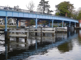
JUST UNDER A YEAR AGO, we visited Cookham in Berkshire, a small town on the River Thames, with our friend ‘H’. I first met H and her widowed mother in about 1975 at the home of some dear friends, my PhD supervisor and his wife. My wife and I used to see H about once a year until about 1999 at the home of our mutual friends. Then, we lost touch. A few years ago, H and I reconnected via social media and we kept promising that we should meet up again. It was only in about July 2020 during a relaxation of the covid19 regulations that we finally met face to face. Our meeting was in Cookham, where we enjoyed an exhibition at the small Stanley Spencer Art Gallery. After having coffee together – it was the first time that H had been to drink coffee outside her home since mid-March, we walked through the rain to Cookham Bridge and crossed it, admiring the lovely views of the Thames.
Cookham Bridge
The roadway on Cookham Bridge is so narrow that traffic must be regulated by signals at both ends of the crossing. These signals allow traffic to flow in single file in one direction for a few minutes, and then in the other. While we walked across the bridge, I noted its lovely decorative iron railings, which can be seen in a painting, “Swan Upping at Cookham” (www.tate.org.uk/art/artworks/spencer-swan-upping-at-cookham-t00525), painted in 1915-19 by Cookham’s famous artist Stanley Spencer (1891-1959).
It was not until April 2021 that we revisited Cookham with some friends and walked along the Thames Path, which passes under Cookham Bridge. It was then that I noticed what we had not seen with H: the interesting Victorian ironwork structure supporting the crossing. A sign screwed onto one of the pontic’s metal panels reads: “Pease, Hutchinson, & Co. 1867. Engineers & iron Manufacturers. Skerne Iron Works. Darlington”. The Skerne Iron Works were:
“…run by a Quaker partnership trading as Pease, Hutchinson and Ledward. The Skerne company built its reputation upon plates for ships, boilers, and particularly bridge building, and at its peak employed 1,000 workers.” (www.gracesguide.co.uk/Pease,_Hutchinson_and_Co)
The iron bridge, supported by pairs of slender iron beams (filled with concrete) with cross-bracing rods, was opened in 1867 to replace an earlier wooden bridge that was opened in 1840. The existing bridge was when it was constructed the cheapest bridge across the Thames for its size (https://en.wikipedia.org/wiki/Cookham_Bridge). Until 1947, it was a privately owned bridge for which users needed to pay a toll. It was owned by the Cookham Bridge Company. In 1947, Berkshire County Council bought the bridge, and the toll was abolished. An octagonal house still stands next to the bridge across the river from Cookham. It is the early 19th century toll house built in 1839 by a Mr Freebody (https://heritageportal.buckinghamshire.gov.uk/Monument/MBC19500).
At the Cookham side of the bridge stands The Ferry pub, close to where there used to be a ferry across the river. This old, half-timbered inn, now a mid-priced eatery, has a lovely terrace by the river, from which the bridge can be viewed as well as the waterways leading downstream to Cookham weir and the lock that bypasses it.
Recently, a close relative of H contacted me. He had found my details in the address book in H’s computer. It came as a shock to learn from him that H had passed away suddenly a few weeks ago. When we had last seen her late last year, she was looking hale and hearty. Apparently, one Saturday, she began feeling extremely unwell and on the following day she expired. We were terribly upset because we got on so well with her and were planning outings with her once the covid19 socialising restrictions were eased. They were relaxed but not in time for us to be able to see H again. As we drove through Cookham on our most recent visit, we kept seeing places that reminded us of our meeting with her last summer.
Our friend with whom we crossed Cookham Bridge last year has crossed from this world into another, where I hope that she will be reunited with her parents, our mutual friends, who introduced her to me and then later to my wife, as well as Sir Geoffrey Howe and Elspeth, his wife, with whom she worked happily for many years. H will be sorely missed.
IF THE RAILWAY authorities did not prevent people from wandering along the track as many people do in India (for example), taking a photograph of an amazing construction at the base of London’s Primrose Hill would be simple. But, wisely, they do not encourage people to risk their lives on tracks that carry high speed trains from London’s Euston station to places north of it. The remarkable edifice to which I am referring is the eastern entrance to the Primrose Hill Tunnels that originally carried lines of the London and Birmingham Railway (‘L&BR’) underground between Primrose Hill Road in the east and Finchley Road in the west. Short of trespassing on the tracks, the best place to see the entrance is through the railings on the north side of King Henrys Road a few feet east of Primrose Hill Road.
The Roundhouse
The Primrose Hill tunnels were the first railway tunnels dug in London and some of the first in the United Kingdom (https://historicengland.org.uk/listing/the-list/list-entry/1329904). The tunnels had to be built strong enough to withstand the weight of houses that were to be built above them. The land beneath which the trains pass is part of the Eton Estate (owned by Eton College). When the railway was being laid in the early 19th century, the Estate raised objections initially, worrying that running a railway through a deep cutting would reduce the saleability of the land, the Chalcot Estate owned by Eton, through which it ran. However:
“The L&BR bought off any possible College obstruction by agreeing to put the line in a tunnel through the Chalcots Estate. From an engineering viewpoint this was unnecessary as the rails were never more than 50 ft below the ground surface, and side slopes of 1 on 2 were specified initially. A tunnel had the merit of using no land, the surface being preserved for building …” (http://www.crht1837.org/history/tunnel).
Digging the tunnels was not without danger. Workmen got killed. When this happened, their bodies were taken at first to be laid out in a local hostelry, The Chalk Farm Tavern. This place in Regents Park Road was rebuilt in 1853-54 and its new building is now home to Lemonia, a popular Greek restaurant. So, next time you are enjoying a plate of tzatziki or a souvlaki, just remember that years ago there was a mortuary for railway navvies near your table.
Today, there are two tunnels commencing at Primrose Hill Road. The northern one, nearest Adelaide Road, was the first to be built, in 1837. The southern one, nearest King Henrys Road, was built about 40 years later. Part of Eton College Estate’s requirements of the L&BR was:
“… the mouth of the Tunnel at the eastern end shall be made good and finished with a substantial and ornamental facing of brickwork or masonry to the satisfaction of the Provost and College…” (http://www.crht1837.org/history/tunnel).
The portals at this end of the tunnel, which can just about be seen from King Henrys Road, are grand and impressive examples of neo-classical Italianate masonry. The northern portal, the first to be constructed, was designed by William H Budden, who was appointed as an office assistant to the L&BR in May 1834 (https://etheses.whiterose.ac.uk/16826/1/Railway%20tunnels%20recovered%203.pdf). The newer southern portal is a replica of the earlier one.
The graffiti-covered iron railway bridge that is 530 yards east of the tunnel, quite close to the house on King Henrys Road once occupied by the Indian politician and lawyer Dr Bhimrao Ramji Ambedkar (1891-1956), is easy to see, but far less attractive than the tunnels’ magnificent portals. Now a pedestrian and cycle bridge, it carries the northern section of Regents Park Road across the tracks. The present bridge, made of iron, was constructed in 1846 to replace an earlier one built in brick in 1839 (http://primrosehillhistory.org/?p=388). Until 1992, passengers could board and disembark from trains at a station at the northern end of the bridge. Opened in 1859, this station was named ‘Hampstead Road’, then ‘Chalk Farm’, and finally ‘Primrose Hill’.
Whereas the Primrose Hill Tunnel portals can only be glimpsed with great difficulty, the largely brick-built Roundhouse, a few yards south of Chalk Farm Underground Station, is impossible to miss. Located close to the railway tracks a few yards east of the Regents Park Road footbridge, this circular building was built as a railway locomotive shed in 1846-47. It was designed by Robert Benson Dockray (1811-1871), who had been an Assistant Engineer during the construction of the pioneering Stockton and Darlington Railway in 1835 (https://www.locallocalhistory.co.uk/ctown/p001/pages39-42.htm). The building was made circular because in its centre there was a turntable for moving the locomotives that were stored on tracks radiating out from it.
In 1967, the then disused Roundhouse was converted into a huge theatre. From the 1970s onwards, I used to attend occasional performances there. Amongst these, I particularly recall a somewhat raunchy show put on by the Grande Magic Circus, a French company, and many years later, an incomprehensible performance of Shakespeare’s “A Midsummers Night Dream”, which was performed in a variety of Indian languages by a troupe of acrobatic gymnasts. In recent years, a sculpture by Antony Gormley has been placed on the roof of a modern annex of the Roundhouse.
Private functions are also held in the Roundhouse. On one occasion, we were invited to a bat-mitzvah held there. Drinks and canapés were served in the circular upper floor gallery that runs around the circular auditorium. I was extremely surprised when one of the other guests came up to me and after looking me up and down, said:
“You must be in the fashion business.”
For a moment I was flattered, then I wondered whether he had had one too many or was visually impaired.