HOLY ISLAND IN the North Sea is reached by travelling along a causeway that links it to the coast of Northumberland. The causeway disappears under water for several hours during high tide, which occurs twice a day.
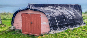
Near the island’s harbour, there are upturned herring boat hulls. Some of them have been covered with a layer of tar. At the rear of each of these hulls, there are doors fitted. For today, these upturned, retired fishing boat hulls now serve as storage sheds.
Apparently, the fishermen of Holy Island consider it sinful to send these boats to breaker’s yards or to otherwise dispose of them. So, they recycle these herring boats (cobles) as sheds.
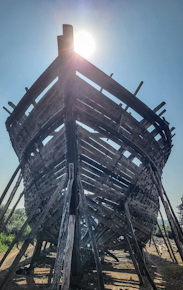
THE SEAPORT MANDVI in the Kutch district of the Indian state of Gujarat was founded by Maharao Khengarji I, the ruler of the kingdom of Kutch, in 1580. It became an important, thriving centre of trade for several centuries. And for over 400 years it has been a place where dhows have been built. Today, these huge wooden ships can be seen in various stages of construction along the banks if the Rukmavati River on whose shore lies the town of Mandvi.
The dhows are constructed largely by hand as they have been done for over 400 years. They are built with timber, sal wood, imported from Malaysia. Today, the timber is landed at the port of Kandla in Kutch a d brought by road to Mandvi.
According to an article in the The Hindu newspaper dated April 2017:
“As maritime trade grew, traders—belonging to the seafaring Kharva community of both Hindus and Muslims—developed a new expertise: boat-making and repairing to add to their traditional navigational skills.”
Furthermore , the arti le related, the dhows:
“… built by hand by craftsmen who are barely literate and have no training in engineering, the ships come up expertly without so much as a sketch being referred to.”
I found this to be quite amazing.
The dhows take several year to be built. When they are completed, they are usually towed to the Persian Gulf where they are fitted with engines. Occasionally, engines are fitted in Mandvi.
Having been fitted with engines in the Gulf, they return to Mandvi with a small crew. Back in Mandvi, the dhows are loaded with cargo and a larger crew before sailing back to the Middle East. About a year after they have been completed, the dhows are sold in the Gulf or East Africa.
Whereas in the past, the dhows had a capacity of about 40 Tonnes, some of those being built today can carry up to 2000 Tonne.
Whenever we visit my wife’s cousins, who lives close to Mandvi, we take a walk along the road next to stretch of shore where the dhows are being made. The huge timber structures, upon which men are assembling the ship using hand held tools. The workmen appear to cling to the beams of timber as they worked on the ship. They do not wear safety harnesses.
The ‘embryonic’ dhows are surrounded by piles of uncut timber as well as the planks that have been cut prior to being attached to the ships being constructed. Apart from the building materials, the area contains numerous stray dogs and the occasional foraging cow.
Mandvi is about 250 miles northwest of Alang (in Saurashtra, Gujarat), which we have visited. It is in Alang that ships that have reached the end of their lives are broken up. I was interested to read in The Hindu article that in Mandvi:
“The boat-makers use old generators discarded from dismantled ships lying in Gujarat’s Alang ship-breaking yard. These are then modified by installing gear boxes in them and converted into boat engines.”
I have no idea for how much longer the handmade dhows will continue to be built in Mandvi. So, if you are able, a visit to Mandvi to see this traditional boat building is well worthwhile. It is handicraft on a huge scale.
THE IMPRESSIVE GATEWAY of India stands on a short promontory surrounded on three sides by the water of the Arabian Sea. The sea surrounding the Gateway is crowded with small, colourful vessels. Seeing one of these craft reminded me of a story told to me by a friend many years ago.
In Bombay
My friend had just returned from Kenya. During his stay there he spent several days at sea on a local trading ship. It was a very basic vessel. He told me that he could not find a toilet on board. Eventually, he could no longer resist the urge, and asked the crew where he could relieve himself. He was directed to the rear of the vessel and shown a toilet seat that was suspended from it over the waters below. With some difficulty he managed to sit on the swinging toilet seat, and to his great embarrassment, the entire crew came to the back of the ship to watch him in action.
That really happened a long time ago. Today, 17 November 2025, while visiting the Gateway of India, I spotted a small boat. Projecting from its rear and hanging over the water, there was a small, square based cubicle with a door. On the door, there was the word “TOILET”. Seeing this reminded me of my friend’s story. Users of this cabin are shielded from sight, unlike that swinging loo seat on the Kenyan boat.
REGULARLY ON SUNDAY mornings, you will see a group of people standing at the northern edge of Kensington Gardens’ so-called Round Pond. It is not truly round, but squarish with rounded corners. This group of men and women will be seen standing close to trolleys on which there might be large model sailing boats. Often, the boats, which are radio-controlled, will be sailing in the pond’s water. These model boat enthusiasts are members of the London Model Yacht Club, which was founded in London in 1876.
Prior to 1876, there were other model boating clubs in London. In the 1820s, a group of model boat enthusiasts used to sail their craft in a pond in Green Park. This pond exists no more. In 1834, when the pond was made inaccessible by railings, the boaters moved to the Serpentine in Hyde Park. The first formal London Model Yacht Club was founded in 1846. Following disagreements, this club was disbanded in 1871. In 1876, the Model Yacht Sailing Association was established. It and another club, the London Model Yacht Club (Est. 1884) have been sailing on the Round Pond since the late 1880s. Before that, they had been using a pond in Hackney. For those interested in the detailed history of model boat sailing in London, please visit www.lmyc.org.uk/history.
Next time you are in London at around 10.30 am on a Sunday morning, visit the Round Pond to watch the model boats ashore and on the water.
I HAVE LEARNED a new word today. It can be used as both a noun and as a verb. The noun is ‘gongoozler’ and the verb is ‘to gongoozle’. I came across it used as a verb on an information panel by the south side of the water basin at Paddington’s Little Venice, where the Paddington Arm of the Grand Union Canal enlarges to become a pond, from which the Regents Canal commences.
The word gongoozle might possibly derive from two words of Lincolnshire dialect: ‘gawn’ and ‘gooze’. Both these words mean to stare or gape. A ‘gawn’ can also mean a small freight-carrying boat such as a canal narrowboat.
Gongoozling usually refers to watching boats. And this is what we did today as we ambled lazily along the Paddington Arm and the shore of Little Venice. With the sun shining and a pleasant air temperature (about 21 degrees Celsius), this was an enjoyable way of passing time on a Sunday morning.
THE GRAND UNION canal, constructed from the late 1790s onwards, is an important artery of England’s canal network. Beginning at Brentford on the River Thames, it winds its way to Braunston and Birmingham. Along its way it meets other canals, some of which are designated ‘arms’. For example, the Paddington Arm joins the main canal at Bulls Bridge in west London and from there it makes its way eastwards to Paddington. Recently, we visited friends, who live in Northamptonshire, and they took us on a walk along another arm of the Grand Union, the Northampton Arm. This branch of the main canal begins near Gayton and Blisworth and runs to nearby Northampton, where it enters the River Nene, which flows eastwards towards The Wash, an enormous inlet of the North Sea.
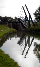
A swing bridge with a lock behind it
Much of the Northampton Arm is very narrow, just wide enough for passage of a single narrow boat. At regular intervals, the arm widens to allow vessels travelling in opposite directions to pass each other. Though short in length, only 4.6 miles, the Northampton Arm has seventeen separate, hand-operated locks for vessels to negotiate. The twelve of these, a flight of locks, is 1123 yards from the Gayton junction with the main canal. These twelve locks are along a stretch of canal only nine tenths of a mile long. The northernmost lock, that nearest towards Northampton, is a few yards north of a bridge carrying the M1 motorway. The locks carry the water from a bit over 300 feet above sea level nearest Gayton down to less than about 225 feet, each lock capable of lifting or lowering a vessel over 6 feet on average. Nearer Gayton, there is an old swing bridge, rather like a castle’s drawbridge. Looking at old maps, it appears that there were several more of these along the arm, but we only spotted one in the stretch between Gayton and the M1.
The canal and its associated towpath pass beneath the motorway through a giant concrete arch, paraboloid in shape and reinforced with horizontal concrete beams. Lined with graffiti, both conventional and anarchic artwork, walking under the motorway is an eery, rather science fictional experience. In contrast to this brutalist concrete arch, several lovely brick, hump-backed bridges carry minor roads over the Arm
“Almost immediately the Arm began to carry a large volume of merchandise and stayed busy for over 100 years through to after the First World War. In the post war years coal, grain and timber were supplemented by goods needed for the show industry such as strawboards for packing as well as iron ingots for castings. After World War II the carriage of goods ceased as road competition strengthened.”
Now, the Arm is used by intrepid canal boat owners, who are not averse to too much manipulation of lock gates. On the sunny Saturday afternoon that we visited the lock flight, we only saw one narrow boat attempting to negotiate the flight of twelve locks. In contrast, at Gayton Junction, the main Grand Union Canal, from which the Arm branches off, was full of pleasure-seekers’ narrow boats and other craft.
Though hardly used for freight these days, the canal system provides much pleasure to visitors both afloat and on shore. Wandering along the towpaths, one cannot fail to be amazed when considering the engineering ingenuity of the canal builders that we can still see today, as well as the work that is done to keep these waterways usable so many years after they were constructed.
BEFORE THE ADVENT of railways, transportation of goods across England (as well as Wales and Scotland) was heavily dependent on an extensive canal system constructed mostly in the 18th and early 19th centuries. Freight was carried along these canals in the holds of long narrow barges, more correctly known known as ‘narrow boats’. They had to be narrow enough to negotiate some of the narrower canals that formed part of the canal network. Prior to the development of steam and other kinds of engines, and even for some years after these became available, the narrow boats were towed by horses. These creatures walked along paths known as ‘towpaths’ that run along one or other side of a canal, except when a canal passed through a tunnel. In the tunnels there were no towpaths, and the boats were propelled by the feet of men lying either above the load on the boat or sometimes on planks projecting from the sides of the vessel, a process known as ‘legging’. The boatmen’s feet literally walked along the tunnel walls, thus moving the boat. Meanwhile, the towing horses walked over the hill through which the tunnel passed. All of this interesting but becomes even more so if you can experience a trip on a canal in a narrow boat.
Several companies offer canal trips between Little Venice (near London’s Paddington) and Camden Lock, east of it. We chose to travel on “Jason”, a narrow boat built in 1906 and one of the last of its era, which is still in use. “Jason” has been little modified compared to others that ply the route along the Regents Canal, a branch of the Grand Union Canal system. “Jason”, which was originally horse-drawn, has been fitted with a diesel engine that occupies part of the small rear located cabin that was once the home to a boatman and his family. Passengers sit in the long, narrow freight hold of the boat under an awning that was added when “Jason” was converted from a freight carrier to a tourist vessel, which has been doing the tours since 1951. Unlike most of the other tourist boats, there are no windows separating passengers from the exterior. This provides for great viewing along the route without the hindrance of sometimes not too clean glass, which might be encountered in other vessels.
The tour starts from a landing stage next to Blomfield Road, close to the cast-iron bridge that carries Westbourne Terrace Road over the Paddington Arm of the Grand Union Canal. At the other end of the trip, passengers disembark or embark next to the popular (not with me) and rather ‘tacky’ Camden Lock Market. The cruise between the two landing stages takes 45 minutes and is highly enjoyable. Travelling eastwards from Little Venice, we were given an extremely clear and intelligent commentary by a lady called Sarah. Various things she told us made a strong impression on me.
The Regents Canal that links Paddington Basin to Limehouse Basin in east London, where it leads to other canals, used to carry a wide range of goods, from coal to cocoa. The waterway passes under both rail and road bridges. Many of the latter have curved arches over the canal; are made of stone; and look older than the rail bridges, most of which have rectangular arches with roofs consisting of metal plates screwed together. Over the years, the tow ropes drawing the narrow boats have cut grooves or notches in the corners of the bridges next to the towpath. Some of the bridges have been protected from this damage by iron brackets placed so that the ropes passed over these instead of the masonry of the bridge. These metal protectors, which were easily replaceable, can now be seen to be notched where the ropes have abraded them.
“Jason”, like most other narrow boats, has a flat bottom and a shallow draught. This is because the water most of the canal system is quite shallow, usually not more than 6 feet deep. The bottom of “Jason” is made of wood (probably elm) and iron, a combination known as a ‘composite’ construction. Few narrow boats with this kind of construction exist today.
The most fascinating thing that Sarah told us related to the history of Lord’s Cricket Ground. In 1787, Thomas Lord (1755-1832), a professional cricket player, opened his first cricket ground in what is now Dorset Square (close to Baker Street Underground station). In 1809, Lord shifted his cricket ground to another location because the rent at his Dorset Square site became too high. The new location was on some disused ground just south of the present Lord’s Cricket Ground. It was where today the Regents Canal emerges from the eastern end of the 272-yard-long Maida Hill Tunnel. Let me explain.
In 1813, Parliament altered the route of the proposed Regents Canal so that it passed right through Mr Lord’s recently relocated cricket ground (www.lords.org/lords/our-history/timeline). Mr Lord was unhappy about this and was not prepared to give up his ground without first going to court. According to our guide, Lord struck a deal with the government. He agreed to move to a new site providing he was given all the earth that was excavated during the construction of the Maida Hill Tunnel. He used the vast amount of excavated earth to lay out the ground on which the present Lord’s Cricket pitches are now located.
Concerning construction, Sarah told us that not only had the tunnels been dug by hand, but also the entire canal system. Most of the manual workers were Irish and were known as ‘navigational engineers’, or ‘navvies’ for short. The base of the Regents Canal is lined with compressed clay to make it watertight, a difficult process when the canal was built.
The cruise between Little Venice and Camden passes through a variety of landscapes, ranging from disused industrial to almost bucolic. The canal passes through the northern edge of Regents Park, where it is lined with trees and parkland. In this stretch of the canal, it is difficult to believe one is in the middle of a huge metropolis and not in the deep countryside. The waterway also passes through the London Zoo. On one side, if you are lucky, you can catch glimpses of African hunting dogs and the occasional warthog in their cages overlooking the canal. Opposite them on the northern bank of the canal is Lord Snowdon’s aviary, now devoid of birds and awaiting a new purpose.
The 45-minute cruise provides an enchanting view of several districts of London. The commentary provided by Sarah and what she pointed out along the route helps recreate in one’s mind the golden age of canal transport. We enjoyed the cruise in both directions and hope that many others will take advantage of the special experience that it provides. For booking details and other practical information, consult “Jason’s” website: www.jasons.co.uk/the-tour
LONDON IS BLESSED with an abundance of open spaces where one can exercise and enjoy reasonably fresh air. In addition to parks, woods, the banks of the Thames, and squares with gardens, the towpaths alongside canals provide visually fascinating places to walk, run, or cycle. These canals used to be important routes along which freight could be transported right across England before they were rendered practically redundant by the advent of the railways. Despite this, they have been maintained and give great pleasure to many people including my wife and me.
Today, the 6th of November 2020, we walked along a branch of the Grand Union Canal from Golborne Road (near Portobello Road), where I practised dentistry from 1994 until about 2001, to Paddington Basin, which only became accessible to casual visitors in about 2000, when it was redeveloped. We began our walk in Meanwhile Park at the base of Trellick Tower, a tall block of flats designed in brutalist style by Ernő Goldfinger and opened in 1972. The pleasant community park, created in 1976, runs alongside a short stretch of the Paddington Arm of the Grand Union Canal, which was opened for use in 1801. We walked across the narrow park and onto the towpath. Although we have walked along this often, what attracted me this time in addition to the variety of barges and waterfowl was the variety of bridges that cross the canal and its towpath. I shall concentrate on these in this essay.
The first bridge we walked beneath is that carrying the Great Western Road over the canal. This is a cast-iron, single-arched bridge with the Union Tavern at its northern end. It looks like a Victorian design. Heading east, after walking beneath the sweeping curve of the Westway, an elevated motorway (the A40), the first bridge we encountered was that which carries the Harrow Road over the canal. This iron bridge with brick abutments is shorter than the previous one because the canal narrows temporarily as it passes beneath it. A few yards east of this, there is another bridge that crosses the canal to reach an old, derelict building that must have been a factory in the past. The bridge, known as the ‘Pipe Bridge’, has a roof and is completely enclosed with translucent panelling. It looks as if it was built in the last few decades and leads from the factory to a solid brick wall which serves as its abutment on the south bank of the canal.
Four hundred yards east of the Pipe Bridge, after passing the green space around the Church of St Mary Magdalene, we pass beneath a concrete footbridge with iron railings and decorative lamp posts that links Delamere Terrace and Lords Hill Road with Blomfield Road across the canal. The approach to the bridge from Delamere Terrace is an elegant helical ramp. This fairly modern crossing is known as the ‘Ha’Penny Bridge’ (i.e. half penny).
The towpath runs south east and alongside Delamere Terrace and reaches the building that houses the Canal and River Trust, the former Toll House. This is next to another bridge, a delicate-looking cast-iron structure with masonry abutments topped with distinctive lamp stands. This carries Westbourne Terrace Road (laid out in the early 1850s) over a constricted section of the canal. East of this the canal enters a vast triangular expanse of water, the junction of three waterways: the Paddington Branch from west London, its continuation towards Paddington Station, and the Regents Canal that leads to Camden Town and further east.
The poet Robert Browning, who lived near to this junction area, or possibly Lord Byron, is credited with christening this district as ‘Little Venice’, the name by which it is known today (https://londoncanals.uk/2010/01/17/the-history-of-the-place-name-known-as-little-venice-and-the-facts-that-are-ignored/). With its willow trees, colourful barges, a wealth of waterfowl, and some floating refreshment outlets, Little Venice is a popular place for tourists both local and from further afield. The small island in the middle of the watery space, inhabited only by birdlife, is called Browning’s Island.
We leave Little Venice by walking south east along the next section of the Paddington Branch canal. Soon, we reach another bridge, an undistinguished structure that carries the Harrow Road over us and another short, constricted section of the canal. The next 450 yards of the towpath on the west side of the canal has been redeveloped recently and is lined with eateries both on the shore and on boats moored alongside the shore.
After walking beneath a concrete bridge, the Westway Viaduct, carrying the Westway high above us, we soon reach a fascinating footbridge over the canal. The span across the water is approached by both curving staircases and spiral ramps. This suspension bridge is supported by cables fanning out from a tall pole on the eastern side of the canal. It is known as the ‘Harrow Road’ footbridge. Despite an extensive search of the Internet, I have not yet discovered who designed this structure, which is a visual delight in comparison with the next bridge we reach, an inelegant concrete span, which carries Bishops Bridge Road.
Shortly before the direction of the canal turns from south east to due east, we need to cross it over a curious looking modern footbridge that runs beneath what looks like a double wall of glass panels. This, the Station Bridge (Paddington Basin), leads from the east side of Paddington Station to a footpath leading to North Wharf Road. It was completed in 2004 by the Langlands and Bell partnership (www.langlandsandbell.com/work/).
Having crossed this distinctive bridge, we are now on the final stretch of this blind ending branch of the Paddington Arm of the canal. Next, we encounter another suspension footbridge with perforated metal panels along both sides of its footway over the water. This bridge leads to a car park next to a twentieth century block, part of St Mary’s Hospital. This is the Paddington Basin Footbridge designed by Sidell Gibson Architects.
A few yards further east, we cross a short blind-ended inlet by means of a short bridge known as The Rolling Bridge. Designed by the Thomas Heatherwick Studio and completed in 2005, this bridge curls up into a circle to allow boats to enter or leave the inlet. Routinely, this pointlessly complex yet interesting bridge is opened briefly at noon on Wednesdays and Fridays and at 2pm on Saturdays.
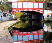
On Fridays at noon, or when necessary, the last bridge over the Paddington Arm, a few feet away from its eastern terminus, can be seen in action. At rest, the Fan Bridge (aka Merchant Square Bridge) looks unexceptional. However, when it is raised to allow passage of vessels it is extraordinary. As the bridge rises, it splits into sections resembling five blades of a pen knife when they are all opened, or a lady’s fan. The bridge is twenty feet long, was designed by Knight Architects, and completed in 2014. We were lucky enough to see this bridge open and then to watch it closing. You can watch this happening on my video at https://youtu.be/UGQERbGo_jU .
Beyond the Fan Bridge, the canal ends abruptly. Trellick Tower, where we began our perambulation was a landmark in modern architecture when it was built. The Fan Bridge, constructed 42 years later, is another exciting development in design. In between the tower block and the unusual bridge, we passed beneath or over several canal crossings representing various points in the history of bridge design, many of them adding beauty to a lovely waterway that provides pleasure for many people.