THE VICTORIA EMBANKMENT was constructed along the River Thames in the 1860s. It was built to enclose a newly constructed sewer: the Main Low Level Sewer, which was part of the grand sewage system improvement project designed by Sir Joseph William Bazalgette (1819-1891). The wall of the embankment facing the river was constructed from large brick-shaped, carved granite stones, each weighing about 1 tonne. Several of these have had to be removed to construct a new sewage conduit – the Thames Tideway Tunnel.
58 of the granite stones have been repurposed to become a series of open-air public art installations. This series was created by Matthew Barnett Howland, Oliver Wilton, and CSK Architects. Small groups of these have been placed in seven locations: St Peter’s Hill, Carter Lane Gardens, St Paul’s Cathedral, Christchurch Greyfriars Church Garden, King Edward St, Little Britain and Smithfield Rotunda. Today, the 31st of July 2024, we came across the group placed in Little Britain, which is not far from Barbican Underground Station. What we saw were 3 of the huge locks of granite arranged in a straight line. A gentleman was using one of them as a bench while he looked at his mobile telephone. Next to them, a wooden sign explained what is going on. This was useful because if there had been no sign next to them, we might not have given them a moment’s notice.
You might well be wondering why this series of stones were placed at seven places in London. I will leave it to someone else to explain:
WHENEVER WE DRIVE to Cornwall, we make sure that we cross Dartmoor. Even if it means taking a detour along the narrow, challenging lanes of Devon, we always visit Combestone Tor. This geological formation, perched on the side of a hill commanding a panoramic view of well over 180 degrees, consists of several piles of enormous, weathered slabs of granite. Each pile has a few of these gigantic slabs piled one above the next. I have described how these impressive piles were formed in something I wrote a few years ago (https://adam-yamey-writes.com/2020/10/04/sculpted-by-nature/).
I cannot say why we find visiting Combestone Tor so satisfying. Is it the fine views over the moor and the countryside abutting it? Or is it the sculptural qualities of the rock formations? Could it be the peacefulness of the place? Even if there are other visitors at the Tor, one does not feel disturbed by them. Or is it the joy of seeing horses, sheep and cattle grazing near the stones? It is probably a combination of all of these, and other factors which affect one’s emotions, but are difficult to define. We have seen the Tor in appalling wind and rain and bright sunshine, and always feel glad that we have made the effort to reach the place.
VISITORS TO QUEEN Elizabeth’s Hunting Lodge in Epping Forest can obtain food and drink at the nearby Butler’s Retreat. I will describe the Hunting Lodge in another essay, and will now concentrate on the small weatherboard clad building called Butler’s Retreat, and something that stands close to it. The Retreat is housed in an edifice that was originally built as a barn in about 1859. The Conservators of Epping Forest converted it into a retreat – a refreshment place – in about 1878.
The Retreats in Epping Forest were originally refreshment stalls set up by the Temperance movement to serve non-alcoholic drinks to the many trippers who came to enjoy the forest. Butler’s Retreat is one of the last surviving Victorian retreats in the forest. Its name derives from that of:
His wife, Hannah, took over the refreshment business in 1903, and the Butler family ran it until 1971. After closing in 2009, the building was refurbished by the City of London Corporation (which maintains the forest) and re-opened as a cafe in 2012. The café no longer confines itself to non-alcoholic beverages. In addition to drinks, it serves a range of snacks and light meals. These can be eaten at tables outside the building or within its attractive dining areas in which supporting timber beams can be seen. They support the roof above the first-floor dining room.
Forty-five feet away from the northeast corner of Butler’s Retreat, there is an intact, but disused, pink granite drinking fountain, which was restored in 2011. Constructed in 1899, it was donated by Sir Edwin Durning-Lawrence, Bart, MP (1837-1914). After studying law at London’s University College, he qualified as a barrister at Middle Temple in 1867. During his working life he was both a Justice of the Peace and served as a Member of Parliament for Truro (from 1895 to 1906). Two of his brothers served as Lord Mayors of London.
Sir Edwin was a prolific author. He is best known for his writing in support of the idea that the plays attributed to William Shakespeare (1564-1616) – the Bard – were not written by him but by Francis Bacon (1561-1626). I am in no position to assess Sir Edwin’s arguments, but I believe that most modern scholars tend to believe that it was not Bacon but Shakespeare who wrote the plays.
Apart from providing the fountain near Butler’s Retreat, Sir Edwin donated his extensive library to the University of London. Also, some of the money he left to the university was used to endow a professorial chair in the History of Art department at his alma mater – University College London.
The drinking fountain at Butler’s Retreat is nothing too out of the ordinary to look at, but I am pleased that I did examine it closely to see what was inscribed on it, and noticed the name of Sir Edwin. It is interesting that this drinking fountain, which was donated by someone who doubted Shakespeare’s authorship, should be situated only a few yards away from a building that was standing during the Bard’s (and Bacon’s) lifetime – Queen Elizabeth’s Hunting Lodge.
THE CHURCH OF ST MARY in Fort St George in Chennai (Madras) was constructed by 1680, when it was consecrated. It is the oldest Anglican church east of Suez.
The church contains a memorial to the founder of the famous American Yale College – Eliahu Yale. He had been Governor of Chennai’s Fort St George, where the church is located, between 1687 and 1692. He had also been the vestryman and treasurer of St Mary’s church.
The font within the church is made of a form of black granite known as Charnockite. This stone is named after Job Charnock (c 1630-1693). A member of the British East India Company, he is credited with founding a British settlement at a pre-existing village on the bank of the Hooghly River. Although the place had already been settled long before his arrival, Charnock’s establishment grew into what is now Kolkata (Calcutta).
In about 1678, Job entered a romantic relationship with a Hindu woman, whom he called Maria. They produced a son and three daughters. The daughters were baptised in the font in St Mary’s in Chennai in August 1689. A few years later, Job died. His funerary monument is in Kolkata, where he passed away. Like the font in Chennai, Job’s tomb, which is housed in a mausoleum in Kolkata, is made of Charnockite. This form of granite can be found in the south of India. It was local to Chennai but far from Kolkata. This type of rock was first described in Tamil Nadu and was named in honour of Job Charnock.
Apart from the font and the memorial to Yale, the church of St Mary’s has many fascinating sculpted monuments to Britishers who died in India or on their way to or from it.
THE TALL GREY GRANITE drinking fountain that stands on the southeast corner of London’s Lincoln’s Inn Fields is no longer in use. The inscription carved on its base reads:
“In memory of Philip Twells. Barrister at law of Lincolns Inn and sometime Member of Parliament for the City of London. 8 May A.D. 1880”
Born the son of a banker John Twells (1776-1866), Philip (1808-1880) attended Oxford University and then was called to the bar at Lincoln’s Inn in 1834. His father was a partner in the private bank of Spooner Attwood & Co. In 1863, that bank was taken over by Barclay, Bevan & Tritton & Co, a precursor of the modern Barclays Bank. It was then that Philip became a partner in the enlarged banking concern. He was MP for the City of London from 1874 to 1880.
A website (www.layersoflondon.org/map/records/philip-twells-mp-banker-and-slave-owner-of-stoke-newington-church-street) recorded that Philip Twells owned 252 slaves in Jamaica, and added:
“The Slavery Abolition Act of 1833 had made the ownership of slaves illegal within the British Empire although servitude was replaced by ‘apprenticeship’ for at least five years. The 1837 Slave Compensation Act provided compensation to owners for the loss of their business assets.”
“Awarded part of the compensation for the Islington estate in St Mary Jamaica with his brother Rev. John Twells …”
The slave-owner compensation awarded to Philip was £4207, which is worth well in excess of £300,000 in today’s money. On his death, Pholip left a substantial fortune to his wife.
The fountain commemorating Twells in Lincoln’s Inn Fields was a gift of his widow, and was erected in 1882. Sadly, this memorial to a former owner of slaves can no longer refresh the passer-by. However, during weekdays, food and drinks can be obtained at a café in the middle of Lincolns Inn Fields. And while you are in the area, do not miss seeing the magnificent Sir John Soane’s Museum on the north side of the Fields.
THE SMALL CORNISH village of Luxulyan has a fine old parish church, which is dedicated to Saints Ciricius and Julitta, both of whom are new to me. This edifice was built in the 15th century and restored in the 19th (https://historicengland.org.uk/listing/the-list/list-entry/1158407). The northern aisle of the church was filled with used books for sale when we visited it. A weathered Cornish cross stands close to the west end of the church. During the 19th century, this was brought to its present location from Three Stiles (near Consence). The church and its churchyard, along with the tiny village are charming, but what caught my eye and raised my curiosity was a building bearing the name ‘Captain TC Agar-Robartes Memorial.’
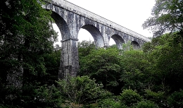
Treffry Viaduct near Luxulyan in Cornwall
The name Agar-Robartes intrigued me. My interest in it increased when I saw a small stone memorial near the River Fowey in Lostwithiel. It bore the words:
“Royal British Legion, Lostwithiel Branch, 1932-1997. Opened by Lady Robartes.”
Things became clearer after visiting the magnificent Lanhydrock House, originally constructed in the 17th century, and reconstructed quite faithfully after a huge fire in 1881. The house was created by John Robartes (1606-1685), 2nd Baron Robartes of Truro, 1st Viscount of Bodmin, and 1st Earl of Radnor. One of his many descendants, Anna Maria Hunt (1771-1861) married Charles Bagenal-Agar (1769-1811). One of their three sons, Thomas James Agar-Robartes (1808-1882), assumed the surname ‘Robartes’ in 1822 and tacked it on to his Agar surname. One of his ten grandchildren was Thomas Charles Reginald Agar-Robartes (1880-1915), the ‘TCR Agar-Robartes’, whose name is on the building in Luxulyan.
Thomas was educated at Eton and Christ Church College, Oxford. He was elected to represent the South-East Cornwall constituency as its MP in 1906. However, he was unseated a month after the election because of infringing some electoral regulations. He had been found guilty of bribery and other offences. Nevertheless, he was re-elected in 1908. His election campaign was based on support of free trade and reform of temperance laws. In August 1914, Thomas signed up as a 2nd Lieutenant in the Royal Bucks Hussars, and then in 1915, wanting to see action on the battlefront, he left for France as an officer in the 1st Battalion Coldstream Guards. In June 1915, he was promoted to become a captain. During the Battle of Loos in September 1915, he was shot in no-mans-land and never recovered.
The building, a working man’s institute and reading room in Luxulyan, which bears Thomas’s name, was first conceived in 1913, but only began to be used as such in 1924, when the edifice was completed. Naming it after Thomas is explained on a website page about the building (www.luxulyanpc.co.uk/Luxulyan_Memorial_Institute_32056.aspx): “ Tragically, as we know, young Tommy Robartes of Lanhydrock died after receiving wounds rescuing a comrade from one of those fields of battle. He had been well known and liked in the village, often coming to visit, accompanying the land agent dealing with tenants. The village picked up its interrupted thoughts on the Institute and Reading Room idea; whether the idea of a Memorial to Tommy, or just asking the Lanhydrock estate for a piece of land came first, is not clear, but it was agreed that a piece of land from the estate for a Memorial Institute was acceptable to all.”
Having already offered £50 towards building the Memorial institute, Dr Nathaniel T Coulson then offered a further £100 on condition that Thomas Agar-Robartes’s name was on the hall. Dr Coulson, who is described in the website, interested me because of his profession:
“He was born in Penzance in April 1853, abandoned by his drunken father at the age of 10 years and bound over to the farmer at Penquite Farm, Lostwithiel. He then spent some years in the British Navy and first arrived in San Francisco in 1875. For a while he worked for a stock-broking firm and wrote for several daily newspapers. In 1884 at the age of 30, he became a student at the dental department of the University of California, where he graduated after two years, receiving his degree as a Doctor of Dental Surgery. He was a member of several fraternal organisations, and generous with donations to many worthy causes. Among others in England, he helped finance the establishment of Coulson Park, Lostwithiel, in 1907. He travelled back here on several occasions, also visiting India after his retirement…”
So, that explains the hall that we saw in Luxulyan. I am not at all sure which ‘Lady Robartes’ is the one whose name appears on the British Legion monument in Lostwithiel, which bears the words “Opened by Lady Robartes”. If a Lady Robartes opened the branch in 1932, who was she? Only one of Thomas’s brothers married, Arthur (1887-1974). His wife, Patience Mary Basset, whom he married in 1920 might have been the ‘Lady Robartes’. Alternatively, she might have been one of Thomas’s sisters: Mary Vere (1879-1946) or Julia (1880-1969) or Edith (1888-1965) or Constance (1890-1936). If on the other hand the words refer to the inauguration of the monument in 1997, then I cannot offer any suggestions.
Luxulyan is worth visiting not only to see the things I have already mentioned, but also the impressive, massive, granite combined aqueduct and viaduct near to the village. It carries water and a railway track over the River Par. Known as the Treffry Viaduct, it was completed in 1844 and designed by the engineer and mining entrepreneur Joseph Treffry (1782-1850).
Until we visited Luxulyan, I had never heard of the Agar-Robartes family. Once again, visiting Cornwall has resulted in finding places and persons of great interest. The more I see, the more I want to know.
WE DROVE AWAY from the sun-soaked, windswept sands on the sea front in Paignton (Devon) and headed upwards on to Dartmoor. We followed narrow roads, often barely wide enough for a single car, bounded by hedges, until we rumbled across cattle grids and entered the wide-open spaces of the moor. The roads remained narrow, but the vistas were wide open. Patches of the moor have been cultivated but most of it is not. Sheep, cattle, and occasional horses or ponies grazed here and there.
We headed up a hill topped with what looked from afar like the ruins of a temple or a small fortress. As we neared it, we saw it consisted of piles of huge flat surfaced, irregularly shaped greyish boulders piled on top of each other in what seemed like a state of precarious balance. It appeared as if a giant had collected these stones and put them together in piles, as if to tidy up the land around them, to clear the space for animals to graze. We had arrived at Combestone Tor. A ‘tor’ is defined as:
“… a large, free-standing rock outcrop that rises abruptly from the surrounding smooth and gentle slopes of a rounded hill summit or ridge crest.”
The definition of tor includes the rocky outcrops I have seen in South Africa, where they are known as ‘koppie’ or ‘kopje’.
We walked from the car park towards the picturesque, tall piles of rocks, the tor, arranged almost artistically. Nature has done a better job aesthetically than many modern artists. A strong warm wind buffeted us as we approached them. It is weather conditions, like wind and rain, that have shaped the stones over the centuries and millennia. The formation of these geological formations began about 280 million years ago when molten rock crystallised to form granite (see: www.dartmoor.gov.uk/data/assets/pdf_file/0025/72097/lab-tors.pdf ). To cut a very long story short, rock covering the granite gradually wore away, allowing the granite to become exposed to the atmosphere. Oversimplifying a lot, the minerals between the lumps of granite became worn away by meteorological forces and, during the ice age(s), by mechanical forces generated by freezing and thawing. What has been left after all this is what we see today.
The earliest surviving written mention of Combestone Tor was in 1333, when it was named ‘Comerston’ (see: http://www.legendarydartmoor.co.uk/combe_stone.htm). On an 1809 map the tor is named ‘Cumstun’. Over the years its name has mutated to ‘Combestone’.
We wandered around the tor enjoying the amazingly balanced jumble of rocks of different sizes and the views of the surrounding landscape that stretches far below the summit of the hill (1168 feet above sea level) on which the weathered stones perch. Nearby brown cattle grazed, probably unaware of the strange geological formations, which we had come to enjoy. Recently, we visited the former home and gardens of the sculptor Henry Moore. His often huge sculptures dominate the landscape like the stone pillars that form the tor. Whereas Moore’s sculptures seemed to intrude on the landscape and deform one’s view of it, the rocky piles that comprise the tor feel harmoniously integrated into their surroundings. Give me moor, rather than Moore, any day!
POSTBRIDGE IS A TINY SETTLEMENT in the middle of Dartmoor on the banks of the East Dart River, a tributary of the River Dart. The road that passes through the hamlet crosses the river over a venerable stone bridge (built in the 1720s). A few yards away from the bridge, there stands a far older bridge, a so-called ‘clapper bridge’.
The clapper bridge consists of four stone abutments (piers) spanned by three wide slabs of granite, each weighing about 6.5 to 8 tons. It is a simple but elegant structure, which has survived for many centuries. The bridge was most probably built to allow pack horses carrying tin to cross the stream on the way to Tavistock on the west side of Dartmoor. It was already in existence in the 13th century and is one of only 40 surviving examples of this kind of river crossing in the British Isles.
When we arrived at Postbridge during our journey from Cornwall to Somerset, the clapper bridge was crowded with camera-laden tourists who spoke German. Some of them were impolite, shouting at us rudely to get us to move off the clapper bridge so that they could get better photographs. Despite their uncultured behaviour, it was good to see that the bridge is still being used, albeit for leisure purposes. However, this is a far cry from what is depicted on a nearby pub sign: a horseman dressed in a red jacket riding his horse over the ancient bridge,
It always amazes me how often one misses the obvious when wandering around London. A few days ago, my friend, the author Roy Moxham, took us to a delightful pub, The Angel, near to Tottenham Court Road Station in central London.
Just before we entered the pub, Roy pointed at a stretch of pavement outside it. The usual paving stones had been replaced by granite slabs surrounded by granite cobble stones (see illustration above).
The reason for these harder stones is that they are less likely than paving stones to be damaged when heavy barrels are dropped on to them by the men delivering beer to the pub.
Since having been shown this localised special surface outside The Angel, I have checked outside other pubs and seen the same thing. For over 25 years (maybe over 7000 times) I have walked past the Churchill Arms in Kensington and NEVER noticed that it also has this arrangement, an area of tough stones close to the pavement entrance of its cellar. And, I consider myself to be more observant than average! It pays to keep your eyes open and to be curious – you never know what you might discover!