
If you are lost
Somewhere deep in the countryside
Look for a signpost

If you are lost
Somewhere deep in the countryside
Look for a signpost
IT IS EASY to understand the great popularity of paintings by David Hockney. They are colourful, often cheerful, and full of life. Until 23 August 2026, there is a delightful exhibition of his work at the Serpentine North gallery in London’s Hyde Park.
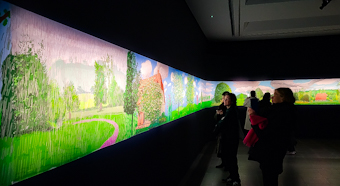
The highlight of the show is a series of prints of images that Hockney created on his iPad in France. They are joined together to form a huge, long picture depicting the seasons in the countryside of Normandy in France. Entitled “A Year in Normandie”, it was inspired by the famous Bayeux Tapestry. However, unlike the tapestry that portrays military activities, Hockney’s twenty-first century take on it contains only idyllic views of a peaceful countryside, changing in appearance as the year proceeds. The result is wonderful.
In addition to the Normandy scenes, there is a good selection of Hockney’s portraits on canvas. Painted mainly during the last year or two, many of them include objects such as tables painted so that perspective has been reversed. For example, the front of a table in a picture is painted narrower than the distant end of it.
All in all, this is a great exhibition. It shows that advancing age need not be an impediment to creative artistic productivity: Hockney is in his late eighties, soon to be 90.

Cows are grazing
Beneath the billowing greyish clouds
A pleasant scene
NOT FAR FROM Henley-on-Thames, lies the village of Bix. Its name might derive from either the Anglo-Saxon word for box, an evergreen shrub, or from a word, ‘behaeson’ meaning ‘to vow’. By 1085, when the Domesday Book was compiled, Bix was divided into two nearby settlements, each of which had its own church. One of these has disappeared, and the other, St James, is now in ruins.

Still consecrated but in a dilapidated state, St James is now known as Bix Old Church. Very little is known about the early history of this ruined church. It was in existence by 1274, when it and the other church were so poor that they had to share a vicar. In the late 1700s, the walls of St James began to collapse. So, brick buttresses were constructed to prevent further damage. These buttresses are still standing, but they failed to halt the collapse of the church. In 1874, the church was deemed unusable, and a new church, the present St James, was built.
We visited the new church, arriving just in time to meet someone who was about to unlock it. Constructed in 1874, it is a Victorian gothic edifice. Inside, the church is built with bricks of differing colours arranged in layers to produce an eye-catching appearance. What makes this church fascinating is that it contains various things that were rescued from Bix Old Church: the font; two fragments of Flemish stained glass dating from 1530; and the carved stone bowl of the piscina. These valuable remains were moved from the old church to the newer one in 1875.
Bix Old Church is reached by a long country lane that is only wide enough for one car. It and the church are in surprisingly a rural environment, considering how close it is to places like Henley, Reading and High Wycombe. We visited the church mainly because when I passed a sign for Bix, which I thought was a strange name, I looked it up on the Internet later while enjoying a picnic, and found out about the existence of the ruined church. Once again, a short visit into the English countryside has resulted in an unexpected, fascinating discovery.
FOR SEVERAL MONTHS following March 2020, movement was restricted to within a short distance of home because of rules that were supposed to limit the spread of covid19 infections. Almost everything except food stores was closed. Socialising was frowned upon. And travel for leisure was not possible. Around about June 2020, things eased up just a little bit, and travelling became possible once more, albeit subject to various rules and precautionary measures. It was then we decided to buy a car to travel around without risking infection by using public transport.

After collecting our (pre-loved) car from a garage on the Edgware Road, we decided to drive up to see my wife’s cousin in Baldock (Hertfordshire). We asked him to recommend a nice country pub where we might be able to get something for lunch. He suggested that we tried Ashwell, which is about 4 miles northwest of Baldock. This pretty village has three pubs. Two of these were closed, and the remaining one did not serve food. We asked the rather melancholic barman to suggest somewhere else in the area. He pointed at the pub’s only customer, a gentleman seated at a table, and said:
“You could try his place at Abington Piggotts – it’s only just up the road.”
The man, Mick, told us that his pub was open and serving food. So, we drove a few miles to tiny Abington Piggotts, which is 3 ½ miles northeast of Royston. With about 80 households, the village has one pub, a free house called The Pig and Abbot. Housed in a century’s old building, this hostelry is a lovely example of an unspoilt country pub. We were given a warm welcome. We enjoyed a small snack and a drink and decided to return at a later date for a proper meal.
We returned and enjoyed excellently cooked food prepared by Mick’s wife Pat. It was so good that we began returning at regular intervals to enjoy Pat’s cooking. The Pig and Abbot, like all other pubs and restaurants, was subject to compulsory closures during the various ‘lockdowns’ that were imposed by the government, yet it has remained in business despite these interruptions. I am not sure how many times we have visited the Pig and Abbot, but each time has been as least as enjoyable as the others. It was not long before we began regarding Mick and Pat as good friends. Whenever we visit the pub, Pat gives us all a great hug when she sees us. Especially during the periods when lockdown restrictions were only partly eased, a visit to the Pig and Abbot provided a welcome respite from the gloomy atmosphere during the height of the pandemic. Whenever we drive along the country lanes leading to Abington Piggott, I have a warm feeling of gratitude because it was this countryside that lightened our lives during two years of covid-related misery.
Recently, we booked for Sunday lunch at the pub. Several days before we were due to eat at the pub, Pat rang. At first, we thought she was going to cancel us for some reason, but it was worse than that. She rang to tell us that Mick had died suddenly and completely unexpectedly. We felt devastated by this news. When we asked her whether she wanted us to cancel, she said ‘definitely not’. She had decided she must continue, and she wanted to see us. When we arrived for our lunch, the pub was full, Pat greeted us warmly, and her food was as excellent as usual. We will greatly miss Mick, and we wish Pat all the very best for the future.
LONDON’S WEST END includes the part of the city that contains areas such as Chinatown, Theatreland, Covent Garden, Leicester Square, Oxford Street, Mayfair, Soho, Fitrovia, and Bond Street. Before the 19th century, the western boundary of London was Park Lane, which runs along the west edge of the West End.

Until the end of the 18th century and even during the early years of the 19th, west of Park Lane and the West End was the Middlesex countryside, which was dotted with villages such as (for example) Paddington, Kensington, Chelsea, Hammersmith, Fulham, Acton, Ealing, and Southall. In between these then separated places there were farms, heathlands, parks, stately homes (such as Chiswick House and Osterley Park), and highwaymen.
During the 19th century, several things happened. London expanded in all directions and spread into what had been countryside. The small villages in Middlesex grew in size. Some of them coalesced. Canals and railways were built, and along with them, building in areas that had previously been rural, caused them to become urban. In brief, London spread relentlessly westward. What was called the West End, and is still so-called today, was no longer the west end of the city of London.
Although many previously rustic settlements (such as Paddington and other places mentioned above) became engulfed in the metropolis, most of them have retained at least a few reminders of their pre-urban past. Currently, I am putting the finishing touches on a book about London west of the West End. In it, I hope to help readers discover more about London’s western spread and what has survived it (despite being surrounded by the city’s western expansion).
THE GREAT SAMUEL Johnson (1709-1784) is supposed to have said to James Boswell on the 20th of September 1777:
“Why, Sir, you find no man, at all intellectual, who is willing to leave London. No, Sir, when a man is tired of London, he is tired of life; for there is in London all that life can afford.”
Now, 245 years later in 2022, I largely agree with Dr Johnson, but not completely. Every now and then, it is wonderful to leave London in search of the open countryside, fresh air, wide expanses of sky, and a different way of life. Equally, it is satisfying to return to the city feeling refreshed and, sometimes, having been away from it, seeing familiar things in a new light. Our excursions from London have ranged from several months to several hours. The latter, shorter outings, have been invaluable during the recent period when because of covid19 travelling abroad has been difficult, to say the least.
One of our current favourite destinations for brief outings is the tiny village of Abingdon Piggots in southern Cambridgeshire. Although it is only about 90 minutes’ drive from central London, it feels as if it is almost in a different world from the metropolis. Despite being close to Baldock and Royston, the village seems as if it is in the deepest countryside. It has not more than 60 well spread-out houses, a church, and a hostelry called the Pig and Abbott.
The Pig and Abbott is run by Pat and Mick. It is a traditional country inn where one can enjoy a drink as well as eating superbly cooked, tasty food. We have visited the pub at least six times since we first discovered it in July 2020. Each time we go there, we are welcomed like old friends. I suppose we have become regarded as ‘regulars’. Mick told me that most of the regulars come from the area around the village. Of the 60 or so households on the village, only about 10 use his pub. I asked him whether we were amongst his furthest customers. He told me that we were, but one of his regulars, who lives in Alaska, always drops in when he visits Cambridge, where he has work colleagues.
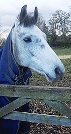
After a hearty meal at the Pig and Abbott, we always take a stroll along Church Lane to see the small church in which there are graves of members of the local Piggott family. The lane is flanked by fields in which one can watch sheep and horses grazing. There is hardly any sound to be heard except birdsong.
Pleasant as is this bucolic scene, it would not suit me to live in it for more than a day or two. I am an urban creature at heart and the humdrum of city life suits me well. My childhood was spent amongst gardens and trees in the Hampstead Garden Suburb in north London, yet I never enjoyed the place as much as central London, which I began visiting with my parents at a young age. I guess that although I enjoy my occasional forays outside London, I cannot disagree with what Johnson said to Boswell all those years ago.
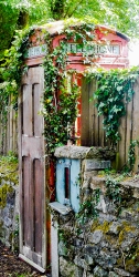
RURAL TELEPHONE BOXES (kiosks) are often used (re-purposed) to house AED defibrillators and small book libraries. Occasionally, they still contain coin-operated telephones. We were driving through rural Cornwall between Bodmin and Luxulyan, when we took a wrong turn and drove along a small lane. After making a three-point turn, I spotted an old telephone box partly covered with vegetation. Its original glazed door had been replaced by a wooden one that was quite out of keeping with the box’s elegant design. The present owner of the telephone box has been using this as the entrance to his or her garden. I was pleased to make find this quirky modification of an old telephone kiosk.
IF YOUR TRAIN FROM CAMBRIDGE to London stops at Shepreth and Meldreth, you can be sure that you are in for a longish journey because only the slower trains halt at these stations. Over the course of many years, we have been travelling to and from Cambridge by train and as I enjoy looking out of the window, I have always noticed this pair of oddly named stations. Only recently, we visited both places by car and took a look around these lovely villages between Cambridge and Royston and close to the A10 road, which runs from London Bridge to Kings Lynn via Cambridge.

The ‘reth’ suffix in the two villages names means ‘stream’. Shepreth means ‘sheep stream’ and Meldreth means ‘mill stream’. There is archaeological evidence of settlements in both places long before the Romans invaded England. The Romans may have occupied part of the parish of Shepreth and their successors, the Saxons, developed the village of Meldreth. Both villages are listed in the Domesday Book (1086). Little appears to have been recorded in the history books about events in tiny Shepreth. The larger village of Meldreth also played no great role in the history of England but, in the 16th century, Christ College of Cambridge moved to its estate near the village to escape from the plague. Members of the Meldreth Local History Group might disagree with my assessment of Meldreth’s place in British history. Their superb website (meldrethhistory.org.uk/) details many aspects of the place’s past, but most of them are about the village rather than the wider world.
I imagine that the building and opening of railway stations in the two villages in 1851 were major events in their history and development. Currently, the stations are served by Thameslink trains. The villages are popular places for commuters to both London and Cambridge.
Both villages are rich in historic buildings of great beauty. Many features of vernacular architecture can be found including many fine thatched roofs. A particularly charming old, thatched edifice In Shepreth is Corner Cottage, which is close to a more aristocratic looking building, Docwra House. This former manor house was built in the 17th century and then provided with later additions (www.docwrasmanorgarden.co.uk/history.htm). The village sign at Shepreth is suitably adorned with sheep, bales of fleece, a stream, a bridge, a water mill, and a leaping fish. The bridge, which we did not see, was built in the 17th century. It crossed the River Rhee, a tributary of the River Cam, in which sheep were washed, and was used by farmers taking sheep to the market in Cambridge.
At Meldreth, through which flows the tiny River Mel, a tributary of the Cam, we entered the parish church of Holy Trinity, whose construction began in the mid-12th century on the site of an 8th century church. Its square tower, nave, and chancel were all constructed in the 12th century. The church contains some fine brass chandeliers; an elaborately carved pulpit and choir stalls with wooden carvings; fragments of pre-Reformation frescoes; a lovely timber beam ceiling; some heavily whitewashed carvings supporting some of the ceiling timbers; and a mediaeval parish chest. The latter is one of about 150 surviving examples. It was made in Baltic pine with iron bands between about 1400 and 1420 and was used for securely storing valuable liturgical items (e.g., silverware, books, and vestments). In addition to visiting the church, we drove through long village to its station, which up until our visit by car, we had only ever seen whilst speeding through it by train. However, we did not see any mills as suggested by the meaning of the name Meldreth.
We did not spend nearly enough time in the two villages as we fitted them into an already busy day of sightseeing. However, having sampled them, we feel that they merit a longer visit in the future. Once again, these places provide good examples of the wealth of historical features to be discovered in England’s rural areas.

HAD YOU VISITED GOLDERS GREEN in 1876, you would have arrived at:
“… a little outlying cluster of cottages, with an inn, the White Swan, whose garden is in great favour with London holiday makers … from the village there are pleasant walks by lanes and footpaths …” So, wrote James Thorne in his “Handbook to the Environs of London”. Of these lanes, Hoop Lane still exists. The White Swan was in business until recently but has disappeared since I took a photograph of it about three years ago.. I do not think that I would recommend Golders Green as a holiday destination anymore. It is not unpleasant, but it is no longer rural and lacks the atmosphere of a resort. The poet and physician Mark Akenside (1721-1770), a friend of the politician Jeremiah Dyson (1722-1776), who had a house in Golders Green, and a frequent visitor to Dyson’s place, wrote, while recovering from an ailment:
“Thy verdant scenes, O Goulder’s Hill,
Once more I seek a languid guest;
With throbbing temples and with burden’d breast
Once more I climb thy steep aerial way,
O faithful cure of oft-returning ill …”
Another poet, now better known than Akenside, William Wordsworth (1770-1850) wrote:
“I am not unfrequently a visitor on Hampstead Heath, and seldom pass by the entrance of Mr Dyson’s villa, on Golder’s Hill, close by, without thinking of the pleasures which Akenside often had there.”
In those far-off days visitors from London could either reach Golders Green by crossing the range of hills north of Hampstead on a road that follows the path of the present North End Road or, after 1835, when it was completed, by travelling along Finchley Road. The end of Golders Green’s existence as a rural outpost of London and its development as a residential suburb began in June 1907, when the Charing Cross, Euston & Hampstead Railway (now part of the Underground’s Northern Line) opened the above-ground Golders Green Station.
My family used Golders Green Station on an almost daily basis. During my childhood, there were two ways of entering it. One way, which still exists, is from the large station forecourt, the local bus and coach station. The other way, which was closed at least 35 years ago, was from Finchley Road. An entrance beneath the railway bridge led to a long, covered walkway (see the illustration above) under an elaborate wooden structure, open to the outside air on most of its two sides. The husband of one of my father’s secretaries once remarked that the wooden canopy reminded him of structures he had seen in India. Having visited India myself, I now know what made him think of that. The walkway led to a ticket office, beyond which there was a corridor from which staircases provided access to the outdoor platforms. Our family favoured using the Finchley Road entrance because it was slightly closer to our home in Hampstead Garden Suburb than the other one next to the bus yard.
In the early 1960s, when I was still a young child, northbound Underground trains coming from the centre of London stopped on one of the two northbound tracks that ran through the station. In those days, the doors on both the left and right sides of the train opened in Golders Green. If the train entered on the left track, that closest to the bus yard side of the station, we used to leave the train by the right hand doors, which led to the platform whose access staircases were closest to the Finchley Road entrance. We did this almost like a reflex action, without thinking about it.
One day, after my father had taken me to spend time in town with him, probably at his workplace, the LSE, we returned to Golders Green by Underground. As usual, since the train had stopped at the platform closest to the bus yard, we waited for the opening of the doors on the right-hand side of the train. Standing facing these doors, we could hear the opening of the doors on the left-hand side. We waited and waited, and then the train began to continue its journey northwards towards the next station, Brent. We were astonished that ‘our’ doors had not opened. My father was mildly upset by this. We behaved like creatures of habit. I was really pleased because I had always wanted to travel beyond Golders Green Station to see what exciting scenery lay beyond it. It was not, I remember, the rural scenes that visitors in the 19th century and earlier would have enjoyed.
