THE PRINTER AND bookseller William Caxton (c1422 – c1491) is believed to be the person who brought the first printing press to England. I do not often think about him, but when we were driving from London to Cambridge, he sprung to mind when I saw a road sign pointing to a place (in Cambridgeshire) called Caxton. I wondered whether this place was in any way connected with the printer Caxton.
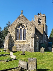
St Andrew, Caxton, Cambridgeshire
Caxton is a small village with some lovely old houses, a pub called The Chubby Frog, and a mediaeval church: St Andrews. The church is a little way out of the village. When we arrived at the place of worship, we saw that there was a sign inviting all to enter to enjoy a coffee morning. We entered, and were made to feel welcome before being served cups of coffee. We spoke with a couple of friendly church wardens, and asked them about any link between their village, Caxton, and the famous fifteenth century printer. The told us that there was no connection between them. Later, I found out that the village’s name was noted as ‘Caustone’ in the 1086 Domesday book.
As for the printer, nobody is certain where he was born, but it has been suggested that it was somewhere in Kent, possibly near (or in) Tenterden or near Hadlow. According to Wikipedia:
“One of the manors of Hadlow was Caustons, owned by the Caxton (De Causton) family.”
Now, De Causton is like the old name of Caxton village, Caustone’. I wonder whether it is remotely possible that the family in Kent might once have lived in what is now Caxton. Just wondering …
QUETHIOCK IS A tiny village in Cornwall. It has a church, St Hugh, that contains many interesting features.
One small thing that fascinated me was a small brass plate attached to a wooden table. It commemorates Dr Erich Schneider of Aussig (Usti na Labem) in Bohemia, who was born in 1889, and perished in the Auschwitz concentration camp in 1944. His wife, Marketa, was interned in the Terezin concentration camp, but survived. She moved to England after WW2. The Schneiders had a son, Johann, who was born in 1921. He was educated in England. At school or college, he became friendly with Reverend Lintell’s children, and spent holidays with them in Quethiock. Later, Johann became an economist at the Treasury, and between 1987 and 2005, he was an assistant pastor at St Anne’s Lutheran Church in London.
It was a great surprise finding this memorial to a victim of the Holocaust in sucharemotepart of Cornwall.
ONE OF MY FAVOURITE uncles used to be highly amused by the name of a place found on maps of eastern England. The place is Six Mile Bottom. The first time I heard him mention the place was when I was about six years old. As far as I can recall, I never visited the place until today (17 March 2025). As we were passing near it, we took a small detour to see it. There is not much to see, but at least I have at last been there.
Six Mile Bottom is a hamlet in the Cambridgeshire parish of Little Wilbraham, which is not far from Cambridge. The place was so named in 1801 because it is six miles from Newmarket and rests in a ‘bottom’ (an old name for a valley).
Before the 1790s, there was only one building in the place. In 1802, a large dwelling was built close by. One of its earliest residents was Augusta Leigh, who was a half-sister of the celebrated Lord Byron. Otherwise, Six Mile Bottom cannot boast of any other noteworthy former or current residents. There was a railway station at the hamlet, which served passengers between the 1860s and 1967. The hamlet still has a single-track railway running past it and boasts of two level-crossings.
During our brief visit to Six Mile Bottom, we parked outside the only shop, the Six Mile Bottom Spar grocery store. Across the road from it, there a carved stone cross, which serves as a war memorial. This monument records the names of the 16 men from Six Mile Bottom, who died during WW1. A side road leads across one of the hamlet’s level crossings to the Church of St George, which is constructed in brick and flint. Its foundation stone was laid in 1933, and the edifice was built by 1935. Mrs Favell Helen Hall, who laid the stone, was the widow of Major Alexander Cross Hall (1869-1920), who served in both the Second Anglo-Boer War and WW1 (www.iwm.org.uk/memorials/item/memorial/82010). The Major’s father, William Henry (Bullock) Hall (1837-1904), was the first-class cricketer and military historian, who changed his surname from Bullock to Hall when he inherited two Cambridgeshire estates from his uncle General John Hall of Weston Colville and Six Mile Bottom. The major lived and died at Great Rollright in Oxfordshire. Our brief visit to Six Mile Bottom today has satisfied my curiosity about the place whose name used to amuse my uncle. I am not sure that I would bother making a detour to see this hamlet too often. Maybe, once is enough.
LONDON HAS ITS Hampstead. Budapest has its Szentendre. Paris has its Montmartre, and Athens has its Plaka. Like these cities, Istanbul also has an area where the city’s citizens meet to relax – Kuzuncuk. This is a village-like settlement on the Asian shore of the Bosphorus in the northeast corner of Üskudar.
We visited Kuzguncuk on a sunny Sunday morning, having walked along the coastal road that leads away from the centre of Üsküdar. As we walked, we watched competitors in a running event, struggling up and down the undulating road from which traffic had been temporarily excluded.
Kuzguncuk
The streets of Kuzguncuk run up hill away from the shore. They are lined with small houses, many of which are picturesque with their timber cladding, small balconies, and other ornamentation. Tables and chairs of cafés, snack bars, and other eateries occupy the pavements. Many of them had customers, who were eating tasty looking breakfast platters, cakes, and other snacks.
As far as we could tell, most of the visitors to Kuzguncuk are Turks. This has not always been the case. Jewish people, who had been expelled from Spain and Portugal, began settling on the village in the 16th century. The earliest tombstone in Kuzuncuk’s Jewish cemetery is dated 1562. The Jewish inhabitants of Kuzguncuk have mostly left – many in 1948. There are two synagogues – one heavily guarded by the police, and the other one more lightly guarded – in the village. Both were locked up.
Armenians began settling in Kuzguncuk in the 18th century. We spotted one of their churches, but it was locked up the service having finished. Following disturbances in 1955, most of the Armenians and Greeks, who lived in Kuzuncuk, left. We passed a couple of Greek Orthodox churches, both locked up. One of them located next door to the heavily guarded synagogue is still in use on Sundays, but we were too late to enter it.
The centre of Kuzguncuk did not have a mosque until 1952. Then, one was built in the courtyard of the Armenian Church of Surp Krikor Lusavoriç. The Armenian community contributed funds towards the construction of this mosque.
When the Greeks, Jews, and Armenians left Kuzguncuk, many of their homes were acquired by migrants from Anatolia.
After spending an extremely pleasant couple of hours in Kuzguncuk, we climbed up the vertiginously steep lanes behind the village, and eventually reached a long main road that led gently downwards to the centre of Üsküdar. As we struggled up a lane, a lady in her garden said to us “Yavaş yavaş” (loosely translated as ‘take it slowly’).
If you wish to escape the crowds of tourists in Sultanahmet and other well-known historic parts of Fatih (the older part of Istanbul in Europe), then head for Kuzguncuk for something delightfully different.
DURING THE 1890S, construction of new concrete naval structures commenced at Plymouth naval dockyard. The nearest source of gravel suitable for incorporating in concrete was in Start Bay on the south coast of Devon (just west of Dartmouth). Dredgers, which were able to suck up vast amounts of gravel from the seafloor, were sent to Start Bay. Every day, enormous amounts of gravel were removed from the Bay.
The remains of Hallsands are thr 2 houses closest to the sea
The inhabitants of the tiny fishing village of Hallsands, whose location was between Beesands and Start Point, noticed that as the gravel was being removed, the level of the sea was gradually lowering. This began to become serious because the gravel that was being removed in vast quantities had formerly protected the village (and others nearby) from being washed away by the action of the sea’s waves. When the authorities became aware of the damage being caused, gravel extraction was ended. But this was too late.
A huge storm in 1917 caused most of Hallsands to be washed into the sea, leaving only a couple of houses standing, albeing precariously. Had the gravel not been removed, the damage might have been considerably less, and more of the village might have survived.
Until recently, the precarious remains of Hallsands could be seen from a viewing platform high above the site. However, during the last year or two, further damage has made the path leading to the platform too dangerous to be used, and it has been fenced off.
Neighbouring coastal villages such as Beesands and Tor Cross, have also suffered damage from the sea because of the gravel extraction, but high thick concrete seawalls were constructed and barriers of huge rocks have been placed, and so far the villages’ integrity has been protected.
Old photographs show what Hallsands looked like before it disappeared. They reveal that its buildings resembled those still standing at Beesands. Whereas this village stands on level ground, the buildings in Hallsands used to line a steeply sloping main street that ran downhill to a small fishing harbour.
Although the tragic consequences of gravel extraction were predicted early enough, cessation of the removal of this protective material did not occur until it was far too late to prevent disaster. The villagers who lost their homes and livelihoods had to wait many years before they received any compensation.
Start Bay is a beautiful place to visit. Had our friends Tim and Christine not taken us there, it is quite possible that we would not have become aware of its tragic recent history.
HAMPSTEAD GARDEN SUBURB (‘HGS’) in north London, where I spent my childhood and early adulthood, is a conservation area containing residential buildings designed in a wide variety of architectural styles. It first buildings were finished in about 1904/5. Despite this, many of the suburb’s houses and blocks of flats were designed to evoke traditional village architecture. Much of HGS contains buildings that do not reflect the modern trends being developed during the early 20th century, However, there are a few exceptions. These include some houses built in the ‘moderne’ form of the Art Deco style, which had its heyday between the two World Wars.
In Lytton Close
A few Art Deco houses can be found in Kingsley Close near the Market Place (see https://adam-yamey-writes.com/2022/02/07/art-deco-in-a-north-london-suburb/), and there is a larger number of them in the area through which the following roads run: Neville Drive, Spencer Drive, Carlyle Close, Holne Chase, Rowan Walk, and Lytton Close. The part of HGS in which these roads run was developed from about 1927 onwards, mainly between 1935 and 1938. So, it is unsurprising that examples of what was then fashionable in architecture can be found in this part of the suburb. According to an informative document (www.hgstrust.org/documents/area-13-holne-chase-norrice-lea.pdf) about this part of HGS:
“… A relatively restricted group of established architects undertook much development such as M. De Metz, G. B. Drury and F. Reekie, Welch, Cachemaille-Day and Lander, and J. Oliphant. H. Meckhonik was a developer/builder and architects in his office may have designed houses attributed to him.”
Most of the Art Deco houses on Spencer Drive and Carlyle Close leading off from it are unexceptional buildings, whose principal Art Deco features are the metal framed windows (made by the Crittall company) with some curved panes of glass. Fitted with any other design of windows, these houses would lose their Art Deco appearances. Number 1, Neville Drive displays more features of the style than the houses in Spencer Drive and Carlyle Close. There is, however, one house on Spencer Drive that is unmistakably ‘moderne’: it is number 28 built in 1934 without reference to tradition. It is an adventurous design compared with the other buildings in the street.
Numbers 13 and 24 Rowan Walk, a pair of almost identical buildings which stand on either side of the northern end of the street, where it meets Linden Lea, stand out from the crowd. They have flat roofs and ‘moderne’ style Crittall Windows. Built in the 1930s, they are cubic in form: unusual rather than elegant.
I have saved the best for last: Lytton Close. This short cul-de-sac is a wonderful ensemble of Art Deco houses with balconies that resemble the deck railings of oceanic liners, flat roofs that serve as sun decks, curved Crittall windows, and glazed towers housing staircases. Built in 1935, they were designed by CG Winburne. I have to admit that although I lived for almost three decades in HGS, and used to walk around it a great deal, somehow I missed seeing Lytton Close (until August 2022) and what is surely one of London’s finer examples of modern domestic architecture constructed between the two world wars. Although most of the Art Deco buildings in HGS are not as spectacular as edifices made in this style in Lytton Close and further afield in, say, Bombay, the employment of this distinctive style injects a little modernity in an area populated with 20th century buildings that attempt to create a village atmosphere typical of earlier times. The architects, who adopted backward-looking styles, did this to create the illusion that dwellers in the HGS would not be living on the doorstep of a big city but instead far away in a rural arcadia.
WHEN PEOPLE CONSIDER picturesque places in the eastern English county of Suffolk, the following places usually spring to mind: Bury St Edmunds, Clare, Southwold, Lavenham, Long Melford, and Sudbury. All these places deserve their reputation as sites worth visiting. Kersey is another place, which is exceptionally attractive. I had never heard about it until someone in a museum (in Essex) told me about it recently. It is far less visited than those mentioned above.
Kersey, Suffolk, England
Kersey is about 9 miles west of Ipswich. The village lies on the steep slopes of the valley of a small stream, a tributary of the River Brett (which feeds the River Stour). The main road running through Kersey crosses the stream not over a bridge but by a ford (known as ‘The Splash’). The village’s name, Kersey, means a ‘wet area with cress’. It is likely that this refers to the part of the place around The Splash. The heyday of the village was long ago: it was during the 14th century when Kersey was important in the then flourishing woollen cloth production industry. The church overlooking the village, St Mary’s, dates from that prosperous era. Likewise, with many of the lovely half-timbered houses. Although their construction began in the 14th and 15th centuries, they have undergone modifications over the centuries. However, they have a picturesqueness that easily rivals that which has made the better-known places (listed above) so famous.
Apart from the church and the half-timbered Bell Inn (about 14th century), one building stands out in Kersey. This is a large building with an impressive 16th century two storeyed red brick entrance structure projecting from the rest of the edifice, which was constructed in the 15th century. Above the main entrance, there is an inscribed stone plaque set into the brickwork. It bears the following: “Ye Olde River House 1490”.
After the Black Death (1346-1353) and later the decline of the wool industry in that part of Suffolk (in about the 17th century), not much happened in Kersey between then and the present, so I was told by a local inhabitant. Nothing much replaced the textile trade, and this led to the village remaining much as it was during its best days. This is lucky for those, like me, who enjoy the charm of England’s older and eye-catching vernacular architecture. Neither I nor the inhabitant with whom I spoke could understand why Kersey, unlike places such as I mentioned at the start of this piece, is not as frequently visited by tourists. Although smaller than all the other places, it easily matches their beauty.
BELIEVE IT OR NOT, busy Fulham in west London was a small country village in the early 19th century. Today, what was once the heart of the village, is the site of two bridges spanning the Thames. One carries the District Line railway tracks and pedestrians, and the other, an elegant stone bridge with five arches carries a road across the river. Known as Putney Bridge, the latter was completed in 1886 and designed by the prolific civil engineer Joseph Bazalgette.
Inside The Eight Bells in Fulham
Prior to the construction of the stone bridge, there was an earlier wooden bridge, known as ‘Fulham Bridge’. With roofed gatehouses at both ends and 26 arches (or openings), it was designed by Sir Jacob Acworth and completed in 1729. Its approach road was Fulham High Street. The bridge has long-since been demolished but a blind-ended, short inlet of the river, now named Swan Drawdock Nature Reserve runs right next to where the old bridge would have once begun.
The Eight Bells pub, which still serves customers, stands on Fulham High Street. Now housed in a Victorian building, it might have been first established as early as the 17th century. When the old bridge stood, it would have attracted much business from folk using the wooden crossing. Things changed when the new, current, bridge was constructed.
The approach to the new crossing, Putney Bridge, was not via Fulham High Street but by way of a new road, the present Putney Bridge Approach (the A 219), which does not pass the front of the Eight Bells. This led to a considerable loss of business for the pub, whose owners received £1000 in compensation: a great deal of money in the late 1880s.
The Eight Bells and its neighbour, a wonderful second-hand book shop, along with a few other shops near Putney Bridge station, although definitely not rural in appearance, retain a ‘villagey’ feel.
TOLLESBURY IN ESSEX on the Blackwater River estuary is a village just over 5 miles southeast of Tiptree, a small town close to the Wilkinson jam factory and museum. This charming village, where a good friend of ours lives, has a venerable parish church, St Mary the Virgin.
Roman bricks used to construct the arch above the south entrance of St Mary’s in Tollesbury, Essex.
In common with most of the parish churches we have visited during our extensive roamings around the English countryside, this church, whose construction had begun by the 11th century, contains a rich selection of interesting features. These are well described in a copiously illustrated booklet about the edifice published by the Friends of St Mary’s Tollesbury in early 2020. Amongst the interesting things we saw within St Mary’s, one of them particularly intrigued me: the incorporation of Roman bricks in the fabric of the church.
Archaeologists have uncovered the remains of a Romano-British cemetery near the village. They have concluded from their findings that in about 200 AD, there was a significant rural settlement located near Tollesbury at that time. Other remains are evidence that the district around the estuarine village has been the site of human activity since the Neolithic era (4000-2000 BC).
As if to prove that recycling is not simply a recent trend, the church of St Mary incorporates bricks made whilst the Romans occupied England. These can be seen clearly above the south doorway within the church. The 11th century arch above this portal is made entirely of recycled Roman bricks. Some more brickwork made with Roman bricks can be seen exposed above the gothic archway in the western wall of the nave, which is also part of the late 11th century bell tower.
Although the re-used Roman bricks have been ‘highlighted’ in St Mary’s, the structure of the parish church in the nearby village of Goldhanger also contains recycled Roman bricks. Making bricks at the time when these churches were built would have been far more laborious than making bricks using today’s industrial techniques. So, re-using bricks that had already been made would have been very sensible.
THE COUNTY OF ESSEX is immediately east of Greater London. Parts of it are heavily built-up and not particularly attractive. The rest of the county is both varied and delightful to explore. So near to London, many parts of it retain rural characteristics, which one might not believe existed so near to the huge city of London. Recently, we visited Goldhanger, a small village close to the River Blackwater’s estuary.
Sculpture by Horace Crawshay Frost in the parish church in Goldhanger, Essex
The village near Maldon (famous for its salt) has been known as ‘Goldanger’, ‘Goldangra’, and ‘Goldangre’. According to Maura Benham (1913-1994) in her history of Goldhanger, the place’s name has always had ‘gold’ as its first part. The gold probably referred to a yellow flower. The second part might either originate in the word ‘hanger’ meaning hill, or ‘anger’ meaning grassland. It is not known exactly when the settlement, which is at the head of a small creek, was first established but there is archaeological evidence suggesting it was already inhabited in the Iron Age around 500BC. One reason for the village’s existence might have been for making salt from seawater. The local saltworks came to an end in the early 19th century.
The heart of the small village is The Square, where Church, Fish, and Head Streets meet. We ate a hearty, tasty lunch in the Chequers Inn. This was listed as the only alehouse in the village in a document dated 1769. It might have been used by smugglers long ago. The building housing it has been used as a pub for at least 250 years. Prior to that it was built about 250 years earlier as a residence. Constructed in stages, the earliest part was probably built in 1500 (http://past.goldhanger.org.uk/Chequers.htm#:~:text=The%20Chequers%20has%20been%20an,landowner%20as%20his%20private%20ressidence.) Inside, the pub, built on several different levels, with an abundance of ageing timber beams, has an authentic ‘olde worlde’ atmosphere and appearance.
The pub is the southern neighbour of the attractive St Peter’s parish church. According to the architectural historian Nikolaus Pevsner, the church originated in the 11th century and some evidence of this can still be observed. The south aisle was built in the 14th century and the west tower in the 15th. Pevsner makes special mention of a tomb chest with a black stone cover plate which has indentations where several brasses used to be. This stands in the South Chapel, which was built by the local Higham family, whose farm was in Goldhanger, in the early 1500s. The chest tomb contains the remains of Thomas Heigham who died in 1531,
Although the church has many other interesting features to enjoy, I will mention only one of them. Located close to the Higham tomb, I noticed a curious wooden carving, a sculpture depicting two forearms with hands clutching or gripping something I could not identify. This was sculpted by Crawshay Frost. According to a short history of the church, this artwork was dated “1960s”. Whether that means it was placed in the church then, or created then, is not stated. I had not encountered the name Crawshay Frost before visiting Goldhanger. A fascinating web page (http://past.goldhanger.org.uk/Frost.htm) described a notable inhabitant of the village, Horace Crawshay Frost (1897-1964), who lived in Fish Street between 1926 and 1964.
Horace graduated in History at the University of Oxford. During WW1, in which he suffered injuries (both physical and psychological), he took many photographs, some of which are now kept in London’s Imperial War Museum. After leaving the army in the early 1920s, he taught at a school in Brentwood (Essex). Soon after that, he moved to Goldhanger, where he gave private tuition to the children of the curate. In Goldhanger:
“… he involved himself in local history, archaeology, art, sculpture, music, ornithology, horticulture, photography and writing, and also established a reputation as a local philanthropist of extreme intelligent. Whether it was because he was sufficiently wealthy, or because he was too ill, or both, it appears that for most of the time he lived in the village he did not engaged in any kind of full time employment, but rather he spent his time enthusiastically pursuing various hobbies and pastimes, and paid others to help him with them.”
On the basis of this information provided on the webpage, I feel that it was Horace, who produced the sculpture I saw in the church. Further evidence of his interest in wood carving comes from a book, “Celebration”, the autobiography of Graham David Smith. He recalled visiting Horace in Goldhanger in 1955, during the time of the so-called Mau-Mau Uprising in Kenya. Smith wrote:
“We had come to work and earn money. Mr Frost had a perfect job for us. Laid out in front of the open kitchen door were several mahogany beams ordered through local woodyards and a large satchel of finely honed steel chisels from Harrod’s. Mr Frost, deeply disturbed by any stories about war, had come by what he thought would be a perfect solution of that awful Mau-Mau business in Kenya: art to soothe the savage breast. To get the Africans started, he had sketched out the wood scenes and motifs he thought conducive to a peaceful and pastoral life.”
On our way from the church back to the car, I noticed three pumps on Head Street, near to the Chequers pub. Two of them, standing side by side, were old-fashioned petrol pups bearing the ‘Pratts’ logo. These well cared for objects were installed in about the 1930s, but maybe originally in Church Street. Opposite these and next to the village car park, there is another pump. This was installed to supply water.
The water pump is above a water well that was dug in the hot summer of 1921. According to a notice affixed to the hand operated pumping mechanism, the well is 70 feet deep “with a further 100 feet of artesian bore, making 170 feet in all.” In 2012, to celebrate the Diamond Jubilee of Queen Elizabeth II, Goldhanger Parish Council restored both pump and well to working condition.
Once again, a brief outing to rural Essex, albeit a small part of it, has proved to be most interesting.