ANYONE FAMILIAR WITH London will know that except for some parkland, the city is a built-up urban environment all the way west from Marble Arch to Acton and further beyond. This is also the case from Hyde Park Corner to Heathrow Airport. However, this has not always been the situation.
When John Rocque (1709-1762) drew his detailed, accurate maps of London in the 1740s, Paddington was a small village separated by open countryside from what was then London. In those days, Kensington was a village reached from London by a country road flanked on its northern edge by Hyde Park. And from Kensington to Hammersmith would have been a ride along a road running between a series of agricultural fields and orchards. And to the north of Hammesrsmith, Shepherds Bush was an open space around which there were only a few well-separated houses. And as for Notting Hill Gate, Rocque did not even bother to name this road junction in the middle of the countryside.
By 1826/27, when C & J Greenwood published their detailed map of London, Earls Court was still a country hamlet; Kensington a small town; and there was barely any development around what is now Notting Hill Gate. However, by 1826 Paddington was beginning to grow and was no longer separated from Marylebone by open countryside. Additionally, the northern edge of the eastern end of Bayswater Road was losing its rural nature and being built upon.
In brief, as the 19th century progressed, London spread west. As it did so, urban development covered what had been open countryside and places that had been separated from London began to become part of it. Places like Kensington, Earls Court, Shepherds Bush, Hammersmith, and places further west were no longer separated by open countryside. Instead, they became engulfed by the expanding metropolis.
My book “BEYOND MARYLEBONE AND MAYFAIR: EXPLORING WEST LONDON” describes in detail how the villages and towns to the west of Park Lane and what is known as ‘The West End’ became engulfed by London’s westward growth. It reveals the history of these places; what they are like today; and what remains of their existence before they became joined to London, as it spread from Mayfair and Marylebone to Heathrow and beyond.
BEYOND MARYLEBONE AND MAYFAIR: EXPLORING WEST LONDON
By Adam Yamey
is available as an illustrated paperback and Kindle from Amazon:
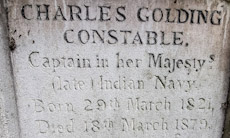
ENCLOSED BY IRON railings, the grave of the artist John Constable (1776-1837) stands at the southern edge of the old part of the churchyard of St John’s Church in Hampstead. The famous painter does not lie alone. He is buried with some other members of his family. One of these people is his second son Charles Golding Constable (1821-1879). I became interested in him when I noticed the words “Captain in her Majesty’s (late) Indian Navy”. The inclusion of the word ‘late’ and its position in the inscription puzzles me.
Charles went to sea as a midshipman in the British East India Company’s navy when he was about 14 years old. According to a genealogical website (www.bomford.net/IrishBomfords/Chapters/Chapter33/chapter33.htm/), he: “…took to the sea, joined the Indian Marine and eventually became a Captain. Around 1836 he left on his first voyage to China and did not return until after his father’s death so missed his large funeral in London. During the 1850s he gained a place in the reference books for having conducted the first survey of the Persian Gulf. He had to struggle with navigation as a youth so he must have shown considerable determination to be entrusted with this survey. Shortly before his survey the Arab sheikhs bordering the southern end of the Gulf gained their income largely by piracy; this was ended by a treaty or truce arranged by the British, and the Sheikhdoms that signed the truce have been called ever since the Trucial States.” A paragraph in the book “Journey to the East” (published by Daniel Crouch Rare Books Ltd.) related this in some detail: “Commander Charles Constable, son of the painter John Constable, was attached to the Persian Expeditionary Force, as a surveyor aboard the ship Euphrates. On the conclusion of the war [the First Anglo-Persian War: 1856/57], Constable was ordered to survey the Arabian Gulf, which occupied him from April 1857 to March 1860, with Lieutenant Stiffe as assistant surveyor. The survey (Nos. 2837a and 2837b) which contains the first detailed survey of Abu Dhabi, would become the standard work well into the twentieth century. During the time that Constable was surveying the Gulf, the Suez Canal, one of the greatest civil engineering feats of the nineteenth century was under construction.” Charles was made a Fellow of the Royal Geographical Society.
While ‘surfing the net’, I found out that sketches made by Charles during his travels have been on sale from time to time in auction houses. His drawings were competent but no match for those executed elsewhere by his famous father.
When John Constable died, his eldest son John Charles Constable became responsible for dealing with his father’s estate. He was then a medical student as well as having studied under the scientist Michael Faraday. According to a website concerning his college in Cambridge (Jesus), John Charles, died suddenly in 1839 after contracting scarlet fever at a lecture in Cambridge’s Addenbrooke’s Hospital, at which a patient suffering this disease was being examined. After his father died, he was left “… numerous paintings and works of art, some of which were known to have adorned his rooms in College.” (www.jesus.cam.ac.uk/articles/archive-month-constable-chapel). In his will, John Charles left his collection of drawings, paintings, and prints to his younger brother Charles Golding Constable. In 1847/48, Charles was responsible for supervising the dispersal of his father’s studio collection of artworks.
Like the rest of his family, parents and siblings, Charles had lived at several different addresses in Hampstead. Although he was buried with other members of the family in Hampstead, I have not yet found out where he resided at the end of his life.
SANTA MARIA DEL GIGLIO, or ‘Santa Maria Zobenigo’ as it is commonly named in Venice, is a baroque church with a magnificent façade. It was built between 1678 and 1681. The edifice was constructed by Giuseppe Sardi for Admiral Antonio Barbaro, who died in 1679. Amongst his many achievements he was Provveditore Generale (Governor General) of Venetian Dalmatia and Venetian Albania in 1670-71.
During my many visits to Venice, most of which were made annually with my parents during the 1960s, I have passed the church and noted an interesting feature of its façade. The base of this is decorated with six carved stone bas-relief maps. These have always fascinated me, but it was only after our recent trip to Venice in September 2022 that I finally got around to investigating them.
The maps are of Spalato (Split in Croatia); Corfu; Roma (Rome); Padoa (Padua); Candia (Haraklion in Crete); and Zara (Zadar in Croatia). Except for Rome, these are all places that were once governed by Venice. The maps depict places where Antonio Barbaro served in one capacity or another.
Wnen James (later Jan) Morris wrote “Venice” (published 1960), which is I believe the best book written about Venice, he/she noted of the façade of Santa Maria Zobenigo that:
“… it is notorious because not one item of its convoluted design has any religious significance whatsoever.”
Morris also pointed out something I have never noticed on that façade. Namely, that it bears a crest with a double-headed eagle, the crest of the Barbaro family. As this symbol interests me, I checked it out. The Barbaro family might have used it because of their connection to the Vlasto family, who were prominent in Rome by the end of 2nd century AD (see; www.christopherlong.co.uk/per/vlasto.byzantium.html). By the end of the 11th century, the Vlasto family was members of important families including the Barbaro’s. The Vlasto family crest includes the double-headed eagle, which amongst other things, was a Byzantine symbol. Interestingly, the Vlasto’s had already begun using it in the early 1st century AD, while the Byzantines only began using it in the 12th – 13th centuries. Maybe I never noticed the double-headed eagle because whenever I have passed the church, my eyes have been drawn to the maps on its fine façade. They fascinated me so much that I never bothered to look upwards.
AL SAQI BOOKSHOP in London’s busy Westbourne Grove occupies a shop with a façade that would not look out of place on a palazzo on the Grand Canal in Venice. I have already described the interesting history of this building elsewhere (https://adam-yamey-writes.com/2020/10/18/the-story-of-a-bookshop/).
62-64 Westbourne Grove, London
Further west along the Grove, well past the Planet Organic ‘wholefood’ store and Alounak, one of the Grove’s several Persian restaurants, we reach number 62-64, whose façade is almost as grand as that of Al Saqi. Unlike the latter, this building’s history is harder to ascertain. Currently, it is the premises of Aveda, a beauty salon also called Gina Conway Salon Spa. The ground floor façade of this edifice includes neoclassical columns with Doric capitals, and decorative mouldings, which include the letters ‘C’, ‘L’, and ‘M’. These are intertwined to form a logo. The first floor is fronted by three large arches separated by decorative mouldings and the top storey has three sets of windows set back behind lintels supported by short columns with Doric capitals. The salon, although modernised to suit its current purpose, has its original elaborately decorated moulded plaster ceiling and wall mouldings, some of which depict the heads of angels or putti. Nobody in the salon had any ideas about the history of this attractive building.
A photograph in the London Metropolitan Archives describes number 62 as having an Edwardian façade. When this image was created in 1974, the building was a branch of the Midland Bank, which occupied its western two thirds. The eastern third of the place was the premises of The French Kitchen and Tableware Supply Company. The bank was already in existence at this address in 1940. What was there before the bank occupied the edifice and when exactly it was built, I have not yet discovered. The building is marked as a bank on a detailed map surveyed in 1914, but not on one surveyed in 1893. However, Allan & Mortons Street Directory of 1867 revealed that number 62 was then the address of Dr Barry, who practised homeopathic medicine. Both the 1893 and the 1914 maps mark the building west of number 62-64 on the corner of the Grove and the western arm of Newton Road as being a bank at those times. This building currently houses Farmacy, a vegan eatery.
The logo ‘LCM’ on the old bank stands for ‘London, City, and Midland’, a bank founded in 1898, which was renamed the London Joint City and Midland Bank in 1918 and then the Midland Bank in 1923 (www.gracesguide.co.uk/London_City_and_Midland_Bank). In the absence of any more information and in view of the fact that the architectural historian Pevsner regarded it as “Edwardian”, it might be safe to conclude that the present building at 62-64 Westbourne Grove was originally constructed to house a bank sometime during the reign of Edward VII, i.e., between 1901 and 1910, and certainly before 1918.
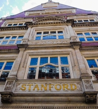
EVER SINCE I CAN REMEMBER, I have been fascinated by maps and collected them. I cannot say exactly why I enjoy them, but one reason is that I get satisfaction from aesthetic aspects of cartography. Another reason is that when I look at them, I try to imagine the reality that they represent, a form of virtual travelling. Whatever the underlying cause(s) of my fascination with maps might be, it is irrelevant to what follows because what I want to tell you is about a shop that I used to love to visit. It was Stanford in London’s Long Acre, a street not far from the old Covent Garden Market and Leicester Square.
Founded by Edward Stanford (1827-1904) in the early 1850s, his business was one of the best specialist suppliers of maps in the UK, if not the very best. His company’s store on Long Acre opened in 1901, having moved there from Charing Cross. When I used to visit the shop to browse the lovely maps on display in the 1960s, there were two floors open to the public. The ground floor was the main showroom with maps of popular destinations that appealed to the majority of customers. The basement was less attractively arranged but far more interesting to serious travellers and map collectors such as me. There were no maps out on display down there. One had to ask a salesman to show you maps of areas that interested you. I believe it was there that I bought a nautical chart of the extremely remote French island of Kerguelen in the southern part of the Indian Ocean, a place that I had no intention of ever visiting.
In about 1966, my interest in Albania was born. I have tried to explain why this happened in my book “Albania on My Mind”, which I published in 2013, 101 years after Albania gained its independence. In those days, not much was known in the UK about this small country in the western Balkans. Maps of Albania were not available in most shops, probably because few people visited the place, or were even remotely interested in it. So, I took the Underground from my local station, Golders Green, to Leicester Square. Stanford was a few yards from that station. At Stanford, I enquired about detailed maps of Albania, and was sent to the specialist map department in the basement.
The only detailed map of Albania available at Stanford was a 1:200,000 scale map with the information that it was made:
“Auf Grund der Oesterreichischer-Ungarische Kriegsaufnahmen und der im Auftrage der Albanische Regierung Von Dr Herbert Louis gemachten aufnahmen sowie mit Benützung italienischer und franzoesischer Karten” (i.e., ‘On the basis of the Austrian-Hungarian war recordings and the recordings made by Dr Herbert Louis on behalf of the Albanian government, as well as with the use of Italian and French maps’)
The map, which comes as two sheets, was up to date in 1925. A small map alongside the main map shows which parts of the large map were surveyed by whom and when. Between 1916 and 1918, the surveyors were the armies of Austria-Hungary, France, and Italy. Some information collected by Baron Nopcsa between 1905 and 1909 is included in the map, as well as data collected by Dr H Louis between 1923 and 1924.
Baron Nopcsa was the Hungarian aristocrat and politician Franz Nopcsa von Felső-Szilvás (1877-1933; see: http://www.smithsonianmag.com/history/history-forgot-rogue-aristocrat-discovered-dinosaurs-died-penniless-180959504/), a founder of paleobiology and a specialist on Albanian studies. This one-time candidate for the throne of Albania created the first geological map of northern Albania. The German Dr Herbert Louis (1900-1985), whose name is prominent on the map, was no stranger to Albania. In 1923, he accompanied the Austrian geologist Ernst Nowack (1891-1946) during his research in the country, and in 1925, he was awarded a doctorate for his studies concerning Albania.
The map looked beautiful, I fell in love with it, and I knew I had to obtain a copy of it, but it was priced at 23/- (23 shillings: £1.15) for the set. That might not sound excessive today in 2021, barely the price of a small bar of chocolate or a cup of tea (in a scruffy café). But in about 1966, it was a huge sum of money for me, many times more than my weekly pocket money. I left Stanford, determined to save up for it and hoping that in the meantime the shop would not run out of copies of it. Eventually, I was able to purchase a set of these maps.
Delicately drawn, covered with contour lines, shaded representations of rocks and mountains, a variety of colours, the map shows how few roads there were in Albania in the 1920s. The tiny black dots, which represented buildings or small groups of them are often shown to be connected by tracks or footpaths, but many of them are a long way from any line of communication marked by the map makers. Most of the names on the map are in Albanian, but a few are also in Italian (e.g., Durazzo [Durres], Valona [Vlora], San Giovanni di Medua [Shengjin], and Santi Quaranta [Saranda]). Some words on the map are also in German.
I treasure this set of maps I bought at Stanford so many years ago and my memory of first being shown them in the basement of the shop. Yesterday, on the 15th of August 2021, first day of the 75th year of India’s independence, we walked along Long Acre, and discovered that although its name on the building is still there, the map shop is not. I had not realised that in 2019 this repository of records of landmarks and one of my favourite childhood haunts had moved from Long Acre to nearby Mercer Walk near The Seven Dials.
EVERY VISIT TO GOLDERS Hill Park in northwest London gives me great pleasure. Now officially part of Hampstead Heath, it contains a lovely feature, its small zoo. This consists of a large paddock containing deer and sometimes a rhea. Close to this, is a series of cages, an aviary, containing exotic birdlife including a laughing kookaburra. These are located next to an enclosure that contains a small group of ring-tailed lemurs. The lemurs’ neighbours are several wallabies and a couple of donkeys, named Sienna and Calypso. The wallabies and the donkeys have a long rectangular sloping field in which to wander.
I have written about the park and the zoo before, and published it elsewhere (https://adam-yamey-writes.com/2020/11/19/walking-past-wallabies/). When I wrote that piece, I did not explore the small zoo’s history. It was certainly present well over 60 years ago, when I was less than ten years old. As a small boy, I remember seeing wallabies and flamingos. More recently, the flamingos have disappeared and have been replaced by ibis and various other exotic fowl. Before my time, the flamingos used to reside in the duck pond next to the park’s walled garden (https://londongardenstrust.org/conservation/inventory/site-record/?ID=BAR027).
The zoo’s history is difficult to ascertain. After searching the Google entries relating to the park and its history, I found only one reference that alludes to the presence of the zoo prior to WW2. This consists of a recording of an interview (https://sounds.bl.uk/Oral-history/Science/021M-C1379X0029XX-0001V0) with the scientist Sir Anthony Seymour Laughton (1927-2019), an oceanographer. Laughton was born in Golders Green, began his education in Hampstead at Heysham School, a ‘dame school’ (private elementary school) in Branch Hill, and moved to Gerrards Cross during WW2 (https://royalsocietypublishing.org/doi/10.1098/rsbm.2020.0021). As a young child, Laughton lived in one of the small roads that lead of North End Road and back on to Golders Hill Park. He and his brother were often taken to Golders Hill Park where he remembered that there was a small zoo with wallabies. This would have been before 1939, when he and his family moved out of London. So, we can conclude that the zoo was in existence before WW2.
According to Pam Fox, author of “The Jewish Community of Golders Green”, Golders Hill Park was popular with local Jewish families, who went:
“Golders Hill Park on Sundays to watch the peacocks strutting around the grounds of Golders Hill House.”
The House was destroyed in 1941. Laughton did not mention these in his interview and, sadly, there are none to be seen today.
To discover whether the little zoo existed before Laughton’s childhood, that is prior to 1927, I looked at a detailed map, surveyed in 1912. This was after the park was opened to the public by the London County Council in 1899, making it the first public park to have been opened in what was then the Borough of Hendon (now incorporated into the Borough of Barnet). I compared what was on that map with what is on modern maps and found that the park’s layout has not changed much since 1912. The bandstand that you can see today is where there was one back in 1912. Where there is the deer enclosure today, there was a similarly shaped and located fenced field in 1912. The same is the case for the long narrow field where you can see the wallabies and donkeys today. The 1912 map does not show any buildings where the aviary is located today, but apart from that the pattern of land enclosures in the part of the park where animals and birds are kept enclosed today is remarkably similar. The question is, and I cannot answer it, was what is now a deer enclosure, then a deer or other animal enclosure? Here is another as yet unanswerable question: did the long rectangular field where the wallabies live today enclose animals for viewing by the public as long ag as in 1912?
Prior to becoming a public park, Golders Hill Park was the gardens of the now long-since demolished Golders Hill House, built in the 1760s for the merchant Charles Dingley (1711-1769), who traded with Russia (www.leeandstort.co.uk/Stort%20History/Charles%20DINGLEY%20Biography.pdf). I have not found any references to any collections of birds and animals in Golders Hill Park prior to the childhood of Laughton, the oceanographer. It is possible that the merchant Charles Dingley or later owners of the property might have kept deer and even exotic creatures, but there is no evidence to confirm or deny this.
What is important, is that the little zoo, which I remember from the 1950s, is still thriving today and providing enjoyment for children of all ages. Whether the various creatures ‘enjoy’ being caged-up and gawped at is a question I cannot begin to answer.
ON OUR WAY FROM Hyde Park Corner to Lowndes Square (in London’s Belgravia), we wandered along a thoroughfare that was new to us, Kinnerton Street. This gently winding road is lined with mainly picturesque buildings and is punctuated by narrow cul-de-sacs, such as Capeners Close and Ann’s Close. At its southern end, the buildings along Kinnerton Street look newer than the others.
The street was originally built for dwellings of those who serviced the far grander buildings that line Wilton Crescent and Wilton Street on the Grosvenor Estate, that began to be built on in earnest during the 18th and early 19th centuries. Kinnerton is the name of a village in Cheshire associated with the Grosvenor family who developed the Estate that includes large parts of Belgravia and Mayfair. Until well after the middle of the 19th century, the street, which was occupied by servants, shopkeepers, tradesmen, and animals, was rather a slum. In more recent years, the street, once the home of the poorer classes, has become gentrified.
Although we were unaware of it when we visited Kinnerton Street, it occupies an important place in the history of medicine. St George’s Hospital was founded in 1733 and later located in a building designed by the architect of London’s National Gallery, William Wilkins (1778-1839). It now houses the upmarket Lanesborough Hotel, which is a few yards from Kinnerton Street.
From the start of 19th century, medical education in England became more structured than before. Pupils at St George’s Hospital were:
After a dispute between the surgeon and anatomist Samuel Armstrong Lane (1802-1892), who had graduated at St George’s and ran one of the anatomy schools (at 1, Grosvenor place; https://livesonline.rcseng.ac.uk/), and the authorities at St George’s Hospital, the latter decided to set up its own dedicated school of anatomy, whose activities it could control. This led to the physiologist and surgeon Sir Benjamin Brodie (1783-1862) buying a house on Kinnerton Street.
Brodie leased the house to St George’s Hospital for use as an anatomy school. It housed an anatomy theatre, a lecture room, and a museum. Until Lane’s school closed in 1863, it was one of two rival anatomy schools serving the students of St George’s. Even though students were taught medicine at St Georges from its inception, a medical school was not formally established until 1834. It was housed in the house on Kinnerton Street and inaugurated in 1835. During the opening ceremony, an Ancient Egyptian mummy was dissected. The school remained in Kinnerton Street until it was moved nearer to Hyde Park Corner in 1868.
Where exactly was the school? Ruth Richardson wrote in her “The Making of Mr Gray’s Anatomy” (published in 2008):
“In addition to its unostentatious frontage on Kinnerton Street, the medical school seems to have had its own discreet rear entrance. Old maps show there to have been an access way bridging the Serpentine River at the back of the building, by which deliveries and collections could unobtrusively be made. It connected to Williams Mews which still joins William Street via an alley … Today, though, this way across the old river has disappeared, entirely blocked by a high wall … The Kinnerton Street Medical School was a large, austere, functional place. Renamed, it still stands, dark and private, enclosed within its own solid walls.”
Based on this information, I looked at a map surveyed in 1869 and found College Place, which was located between Kinnerton Street and the short William Street. It does not appear on current detailed maps. The northern end of William Mews lay close to College Place. A modern description of Kinnerton Street (https://issuu.com/chestertonhumberts/docs/low_res_grosvenor/66) includes the following:
“Studio Place, renamed in 1931, was built as College Place in 1844. It contains Bradbrook House, which until the 1890s, was a series of schools of anatomy.”
In case you were wondering, the Serpentine River, mentioned above, was another name for the now subterranean River Westbourne, a tributary of the Thames. From the eastern end of the Serpentine Lake in Hyde Park, it flows south between William Street and William Mews.
All of this, interesting as it is, becomes more interesting to the general reader, who, even if not connected with medical science, will likely be aware of the book, “Gray’s Anatomy”, whose title inspired that of a TV series. Written by Henry Gray (1827-1861), this famous textbook of anatomy, which is still used, was first published in 1858. The first edition was dedicated to Brodie, who established the anatomy school in Kinnerton Street. In 1842, Gray enrolled as a student at St George’s Hospital and it is highly likely that he honed his knowledge of anatomy at Kinnerton Street. By 1853, Gray had been appointed a lecturer of anatomy.
In a review of a book about Gray, Caroline Rance wrote that:
By walking down Kinnerton Street, as we did recently, maybe we were walking where once the famous anatomist, Henry Gray, used to enjoy a spot of fresh air after hours of dissecting corpses or whilst walking to his home on nearby Wilton Street.
THE BATTLE OF PORTOBELLO (or ‘Porto Bello’) was fought between the forces of Britain and Spain on the 20th of November 1739. The British were aiming to capture the settlement of Porto Bello in Panama during the early stages of the War of Austrian Succession (1740-1748). The victorious British naval force of only six heavily armed vessels was commanded by Admiral Edward Vernon (1684-1757). This gentleman has been accredited for coining the word ‘grog’, meaning rum diluted with water.
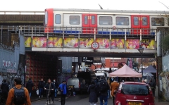
Rail bridge over Portobello Road
A map of Kensington drawn in about 1810 marks a ‘Portobello Farm’ next to what is now Portobello Road. The owner of the farm is said to have named his farm thus to honour Admiral Vernon’s capture of the Panamanian town of Porto Bello. The road or track running past the farm was called ‘Portobello Lane’. In the early 19th century, the farm stood alone amongst open fields where cows, pigs, and sheep grazed.
A detailed map surveyed in 1865 shows the farm located near a slight bend in Portobello Lane, about 270 yards north of a bridge carrying the railway across the lane, 280 yards east of ‘Notting Hill Station’ (now Ladbroke Grove Station). Almost across the road from the farm, there is marked ‘Notting Barn Lodge’. A lane led west from there to a larger building marked ‘Notting Barn’.
Notting Barn was the manor house of the Manor of Knotting Barns. Writing in 1820, Thomas Faulkner, author of “History and Antiquities of Kensington”, noted:
“In the midst of these meadows stands the Manor House of Knotting Barns, now occupied by William Smith esq. of Hammersmith, it is an ancient brick building, surrounded by spacious barns, and outhouses; the road to Kensal Green passes through the farmyard.”
The manor was part of the property of the De Veres, as is evidenced by a document dated 1476. In that year, it was seized by the Crown. In 1543, when the manor was owned by Robert Wright, it was sold to King Henry VIII. Then, through the centuries the manor changed hands frequently. The manor gave its name to the area now known as ‘Notting Hill’. The name of the manor and the present district might well have Saxon origins. Florence Gladstone, writing in 1924 (www.theundergroundmap.com/article.html?id=56157&annum=3000), suggested that a:
“…Saxon family, the Cnot-tingas, or ” sons of Cnotta,” may have made a clearing for themselves in the denser wood to the north. No less an authority than Dr. Walter W. Skeat suggests this Saxon solution for the name of Notting Hill. Other writers have thought that the encamp-ment was founded by followers of King Knut. Whether Saxon or Danish in its origin the little colony seems to have been entirely wiped out before the Norman Conquest; nothing but the name remaining to testify to its former existence. The popular belief that Notting Hill owes its name to the nut bushes which grew upon its slopes is a pleasant, but untenable, tradition. The name occurs in the Patent Rolls for A.D. 1361. There it is ‘Knottynghull’, proving that the ‘k’ is original as is also the double ‘t’ .”
By 1897, both Notting Barn and Portobello Farm no longer appeared on the map and Portobello Lane had been renamed ‘Portobello Road’. Notting Barn Manor House stood approximately where today St Marks Road and Bassett Road meet. Where the farm had once stood, there were residential streets that still exist, including Bevington, Blagrove and Raddington Roads. Across Portobello Road almost opposite the site of the farm there was a large building labelled ‘Franciscan Convent’ and opposite it just north of the former farm there was another large building, which is unlabelled on the map but was ‘St Joseph’s Home for the Elderly’.
St Josephs was founded by a Roman Catholic order, The Little Sisters of the Poor (https://ezitis.myzen.co.uk/stjosephshome.html). They bought Portobello Farm on the 7th of June 1865. They resided nearby whilst the farm buildings were demolished and their new convent and home for the elderly was being built. The home for the elderly opened in 1869. The home was finally closed in 1978. After being demolished in the early 1980s, a new housing estate, St Josephs Close, was built in 1986 with its entrance on Bevington Road. The old convent wall that runs along the east side of Portobello Road has become an open-air public art gallery.
Across the road and almost opposite the former farm and its successor, St Josephs, stands a formidable looking building that currently houses a Spanish school, the Vicente Cañada Blanch Spanish School. This was originally occupied by nuns of the Third Order of St. Francis, whose convent had been founded in 1857. The building was designed by Henry Clutton (1819-1893) and built in 1862, but it was modified and enlarged later.
Nothing remains of either the manor house or Portobello Farm. However, the slight bend in Portobello Road near the Spanish school is as it was when the farm existed as can be seen on detailed maps that marked the farm. The entrance to the farm was on a stretch of Portobello Road north of the elevated Westway (the M40 motorway). On Fridays and Saturdays, this section of the road becomes an open-air ‘flea market’, a scruffy extension of the main Portobello Road market south of the motorway and railway bridges that have been built close to each other where they traverse the busy market precinct.
I worked in Golborne Road for several years, near the streets that now cover the former Portobello Farm. Many of my patients lived in those streets. Most of them are probably unaware of the erstwhile existence of the farm, as was I until I researched this short essay.
MY LOVE OF MAPS started soon after I was able to read. I was given a book that fascinated me for many years. It was called “The Map that came to Life” by HJ Deverson and R Lampitt. First published in 1948, it follows a couple of children walking through the countryside with their dog, guiding themselves with an Ordinance Survey map. On each page, there is a bit of their map and an illustration showing the terrain which is on that portion of the map. Not only did it teach me something about map reading but it helped me to visualise in three dimensions what is being represented in two dimensions on a map. It was one of my favourite books during my childhood.
From the age of eight years onwards until I was thirteen, I attended the Hall School, which is near to Swiss Cottage (in northwest London). Although there was a lot that I did not like about this academically top-rate establishment, I am grateful for at least one thing. One day when we were learning about Ordinance Survey maps in a geography class, our teacher gave us an exercise that stimulated a hobby that lasted until my late teens. The exercise was to draw an Ordinance Survey map of an imaginary place making correct use of the various symbols that appear on the real maps. Of all the academic tasks I was required to perform at the Hall School, this was the best.
Inadvertently, our geography teacher had sparked off a new craze for me. That was drawing maps of imaginary places. I was inspired not only to emulate Ordinance Survey maps but also to create maps of imaginary places in the styles of the ever-increasing number of maps that I had begun acquiring as a passionate map collector. I drew these maps using pencils, water-colour paints, biros, and fine-tipped Rotring pens (such as are used by architects and technical draftsmen). Drawing maps occupied much of my precious spare time, time which my friends spent socialising and meeting members of the opposite sex.
After a while, I began drawing maps of an imaginary country, a socialist republic behind the so-called ‘Iron Curtain’. In addition to creating maps of my geographic invention, I produced illustrations, tourist brochures, and so on. Be patient because I shall say much more about this imagine land in future postings.
When I began studying at university in 1970, my map drawing activities ended. However, my fascination with maps has never diminished. While sorting things at home, I have found the maps and drawings I made during my teenage years. Gradually, I will share some of these with you, dear readers.
I began this piece with a mention of a book that described a map that came to life. It was first published before I was born. Today, the authors’ concept has almost become reality with Google Maps. This useful service provides fairly detailed maps, which at the click of a ‘button’ become aerial views of the area that has been mapped out. At the click of another button, you can travel (virtually) along the streets on the maps and see the buildings and other things along them. While the maps do not really come to life, the Google mapping service has brought us closer to that happening for real. Let us wait and see what the future brings in the way of remote realisation of life in places on the map.
ONE OF THE JOYS OF driving a car is that you can go wherever you wish. To get from A to B, you can either take the most direct route or find a more interesting one. We often opted for the latter.
We used to do driving holidays long before ‘satnavs’ and Google mapping were available to ordinary motorists. We relied on maps and atlases, always trying to find the most detailed available.
In Easter 1993, we sailed from Swansea in Wales to Cork in Eire. After a superb breakfast in Cork, which included some of the best black pudding I have ever eaten, we began driving towards Kilshannig near Castlegregory on County Kerry’s Dingle Peninsula.
Armed with a detailed Michelin road map and with a whole day ahead of us, we opted for a picturesque, but less direct, route.
Two interesting features of Irish roads soon became evident. First, there were bifurcations or t junctions where the same destination was on signs pointing in opposite directions. This was not a joke to confuse but simply an indication that both roads eventually met in the same place, maybe, for example, having skirted around different sides of a hill. The other thing is that we would be driving along a road and spotted a sign saying it was ‘5’ to the next village. Soon after that, another sign would inform us that it was ‘7’ to the same place, even though we knew for sure that we were going in the right direction. Ireland was busy converting its road signs from miles to kilometres, but many of the signs failed to include to which unit of measurement they referred.
We turned on our radio and listened to a programme in which someone was describing how to improve one’s skills when playing the game of curling. Every now and then, the presenter would say something like: “Now, you hold it like this, see?” The only problem was that there is nothing to be seen during a radio broadcast.
It was a lovely day and we were driving with the roof open. We drove past a golf course when suddenly there was a sharp clunk on the strip of roof between the car’s front windscreen and the open roof window. A poorly skilled golfer had made a poorly aimed shot. His ball had struck the car. Had it struck any where else, there was a good chance that it neither hit one of us nor shattered the windscreen.
Eventually, we reached Kenmare, having passed through Bantry Bay. Our most direct route would have been to go from Kenmare to Killarney via Muckross. However, my wife had discovered an alternative route on the map. It was marked on the map using the thinnest white line, which on Michelin msps denotes the most basic rustic thoroughfare. It was the road across a mountain pass called the Gap of Dunloe.
At first, the picturesque narrow road, not much wider than our Volvo saloon car, was easy to negotiate. We notice no other cars on it, but plenty of walkers and cyclists.
Soon, the track began to ascend, but not in a straight line. It wound up in a series of tight hairpin bends with very few passing places. After a while, we met a car coming down in the opposite direction. It was clear to me that my driving skills were better than the other. So, I had to reverse around several hairpin bends to reach a passing place.
We made it over the summit of the pass, and reached our hosts, Rober and Margaret at their cottage at Kilshannig, on a spit of land almost surrounded by sea and distant mountains: some of the beautiful scenery I have seen in Europe.
After welcome cups of tea, we told our hosts about our journey from Cork to Kilshannig. When we told them that we had driven across the Gap of Dunloe, Margaret exclaimed: “But, that’s a footpath. We have often thought of visiting it, but we were worried that neither our Land Rover or our car would be able to cope with crossing the Gap.”