The artist’s son in her Majesty’s Indian Navy

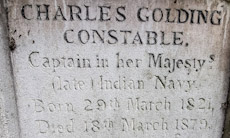
ENCLOSED BY IRON railings, the grave of the artist John Constable (1776-1837) stands at the southern edge of the old part of the churchyard of St John’s Church in Hampstead. The famous painter does not lie alone. He is buried with some other members of his family. One of these people is his second son Charles Golding Constable (1821-1879). I became interested in him when I noticed the words “Captain in her Majesty’s (late) Indian Navy”. The inclusion of the word ‘late’ and its position in the inscription puzzles me.

Charles went to sea as a midshipman in the British East India Company’s navy when he was about 14 years old. According to a genealogical website (www.bomford.net/IrishBomfords/Chapters/Chapter33/chapter33.htm/), he:
“…took to the sea, joined the Indian Marine and eventually became a Captain. Around 1836 he left on his first voyage to China and did not return until after his father’s death so missed his large funeral in London. During the 1850s he gained a place in the reference books for having conducted the first survey of the Persian Gulf. He had to struggle with navigation as a youth so he must have shown considerable determination to be entrusted with this survey. Shortly before his survey the Arab sheikhs bordering the southern end of the Gulf gained their income largely by piracy; this was ended by a treaty or truce arranged by the British, and the Sheikhdoms that signed the truce have been called ever since the Trucial States.” A paragraph in the book “Journey to the East” (published by Daniel Crouch Rare Books Ltd.) related this in some detail:
“Commander Charles Constable, son of the painter John Constable, was attached to the Persian Expeditionary Force, as a surveyor aboard the ship Euphrates. On the conclusion of the war [the First Anglo-Persian War: 1856/57], Constable was ordered to survey the Arabian Gulf, which occupied him from April 1857 to March 1860, with Lieutenant Stiffe as assistant surveyor. The survey (Nos. 2837a and 2837b) which contains the first detailed survey of Abu Dhabi, would become the standard work well into the twentieth century. During the time that Constable was surveying the Gulf, the Suez Canal, one of the greatest civil engineering feats of the nineteenth century was under construction.”
Charles was made a Fellow of the Royal Geographical Society.

While ‘surfing the net’, I found out that sketches made by Charles during his travels have been on sale from time to time in auction houses. His drawings were competent but no match for those executed elsewhere by his famous father.

When John Constable died, his eldest son John Charles Constable became responsible for dealing with his father’s estate. He was then a medical student as well as having studied under the scientist Michael Faraday. According to a website concerning his college in Cambridge (Jesus), John Charles, died suddenly in 1839 after contracting scarlet fever at a lecture in Cambridge’s Addenbrooke’s Hospital, at which a patient suffering this disease was being examined. After his father died, he was left “… numerous paintings and works of art, some of which were known to have adorned his rooms in College.” (www.jesus.cam.ac.uk/articles/archive-month-constable-chapel).
In his will, John Charles left his collection of drawings, paintings, and prints to his younger brother Charles Golding Constable. In 1847/48, Charles was responsible for supervising the dispersal of his father’s studio collection of artworks.

Like the rest of his family, parents and siblings, Charles had lived at several different addresses in Hampstead. Although he was buried with other members of the family in Hampstead, I have not yet found out where he resided at the end of his life.

What! Why? Is there no Calcutta on the map?

VINCENZO MARIA CORONELLI (1650-1718) who was most likely born in Venice (Italy) was not only a Franciscan friar but also a cartographer. Recently, I spotted one of his maps hanging in a frame in a friend’s home. It is a beautiful work of art, bearing the title (translated from French): “Maritime route from Brest to Siam and from Siam to Brest”. It was made between 1685 and 1686, based on information provided to Coronelli by six Jesuit priests sent out to the Indies by the King of France. Coronelli, based in The Republic of Venice, drew the map.

I was particularly interested to see what of modern India is represented on the map. On the coast of “Guzararatte ou Cambaje” (i.e. Gujarat or Cambay), the Island of Diu, then a Portuguese settlement, is marked, as are “Surate” (Surat) and “Bombaim” and “Chaul” (also  Portuguese settlements). Further south, Goa is marked, and yet further south along the west coast, we can see Calicut and Cochin. On the east coast of India, we can see “Fort S. Thomé” and “Mahapur”, being old names for a place immediately south of Chennai and Mahabalipuram respectively.

The map becomes more interesting when you look at the “Bouches du Gange” (the mouths of the Ganges). Coronelli draws a complex collection of island’s that depict  the Ganges delta, but where one would expect to find Calcutta (Kolkata) on modern maps, there is only a small inset town plan of a place called “Louvo”. This is not a place in India but in modern Thailand (once known as ‘Siam’): its modern name is Lopburi.

The reason that Calcutta is not marked on Coronelli’s map is simple: the place with that name did not exist when the Jesuit priests reported back to Coronelli. Had they made their survey only a little later, they would have been able to report its existence because in August 1686 Job Charnock (c1630-c1692/3) established a trading post (‘factory’) on the River Hooghly, and that became known as Calcutta.  I have visited his grave and mausoleum in central Kolkata.

A lost landmark and a treasured map

EVER SINCE I CAN REMEMBER, I have been fascinated by maps and collected them. I cannot say exactly why I enjoy them, but one reason is that I get satisfaction from aesthetic aspects of cartography. Another reason is that when I look at them, I try to imagine the reality that they represent, a form of virtual travelling. Whatever the underlying cause(s) of my fascination with maps might be, it is irrelevant to what follows because what I want to tell you is about a shop that I used to love to visit. It was Stanford in London’s Long Acre, a street not far from the old Covent Garden Market and Leicester Square.

Founded by Edward Stanford (1827-1904) in the early 1850s, his business was one of the best specialist suppliers of maps in the UK, if not the very best.  His company’s store on Long Acre opened in 1901, having moved there from Charing Cross. When I used to visit the shop to browse the lovely maps on display in the 1960s, there were two floors open to the public. The ground floor was the main showroom with maps of popular destinations that appealed to the majority of customers. The basement was less attractively arranged but far more interesting to serious travellers and map collectors such as me. There were no maps out on display down there. One had to ask a salesman to show you maps of areas that interested you. I believe it was there that I bought a nautical chart of the extremely remote French island of Kerguelen in the southern part of the Indian Ocean, a place that I had no intention of ever visiting.

In about 1966, my interest in Albania was born. I have tried to explain why this happened in my book “Albania on My Mind”, which I published in 2013, 101 years after Albania gained its independence.   In those days, not much was known in the UK about this small country in the western Balkans. Maps of Albania were not available in most shops, probably because few people visited the place, or were even remotely interested in it. So, I took the Underground from my local station, Golders Green, to Leicester Square. Stanford was a few yards from that station. At Stanford, I enquired about detailed maps of Albania, and was sent to the specialist map department in the basement.

The only detailed map of Albania available at Stanford was a 1:200,000 scale map with the information that it was made:

“Auf Grund der Oesterreichischer-Ungarische Kriegsaufnahmen und der im Auftrage der Albanische Regierung Von Dr Herbert Louis gemachten aufnahmen sowie mit Benützung italienischer und franzoesischer Karten” (i.e., ‘On the basis of the Austrian-Hungarian war recordings and the recordings made by Dr Herbert Louis on behalf of the Albanian government, as well as with the use of Italian and French maps’)

The map, which comes as two sheets, was up to date in 1925. A small map alongside the main map shows which parts of the large map were surveyed by whom and when.        Between 1916 and 1918, the surveyors were the armies of Austria-Hungary, France, and Italy. Some information collected by Baron Nopcsa between 1905 and 1909 is included in the map, as well as data collected by Dr H Louis between 1923 and 1924.

Baron Nopcsa was the Hungarian aristocrat and politician Franz Nopcsa von Felső-Szilvás (1877-1933; see: http://www.smithsonianmag.com/history/history-forgot-rogue-aristocrat-discovered-dinosaurs-died-penniless-180959504/), a founder of paleobiology and a specialist on Albanian studies. This one-time candidate for the throne of Albania created the first geological map of northern Albania. The German Dr Herbert Louis (1900-1985), whose name is prominent on the map, was no stranger to Albania. In 1923, he accompanied the Austrian geologist Ernst Nowack (1891-1946) during his research in the country, and in 1925, he was awarded a doctorate for his studies concerning Albania.

The map looked beautiful, I fell in love with it, and I knew I had to obtain a copy of it, but it was priced at 23/- (23 shillings: £1.15) for the set. That might not sound excessive today in 2021, barely the price of a small bar of chocolate or a cup of tea (in a scruffy café). But in about 1966, it was a huge sum of money for me, many times more than my weekly pocket money. I left Stanford, determined to save up for it and hoping that in the meantime the shop would not run out of copies of it. Eventually, I was able to purchase a set of these maps.

Delicately drawn, covered with contour lines, shaded representations of rocks and mountains, a variety of colours, the map shows how few roads there were in Albania in the 1920s. The tiny black dots, which represented buildings or small groups of them are often shown to be connected by tracks or footpaths, but many of them are a long way from any line of communication marked by the map makers. Most of the names on the map are in Albanian, but a few are also in Italian (e.g., Durazzo [Durres], Valona [Vlora], San Giovanni di Medua [Shengjin], and Santi Quaranta [Saranda]). Some words on the map are also in German.

I treasure this set of maps I bought at Stanford so many years ago and my memory of first being shown them in the basement of the shop. Yesterday, on the 15th of August 2021, first day of the 75th year of India’s independence, we walked along Long Acre, and discovered that although its name on the building is still there, the map shop is not. I had not realised that in 2019 this repository of records of landmarks and one of my favourite childhood haunts had moved from Long Acre to nearby Mercer Walk near The Seven Dials.

The dragons return

WHEN I FIRST VISITED Kew Gardens, I was a teenager, the entrance fee was sixpence (2.5 pence), and you entered via a metal turnstile. I did not visit Kew often in those days because it was a long way from my family home in northwest London. Recently, we have been exploring the delights of Kew Gardens occasionally with our friends who live in the heart of nearby Richmond town. During our most recent visit, whilst drinking coffee outside the former Orangery, now café, I stared at the nearby red brick building, Kew Palace, and began wondering about the history of the site, where the botanical gardens now stand, before Kew Gardens were opened to the public in 1840.

Kew Palace, which is also known as the ‘Dutch House’, now within the botanical gardens, was built on the site of a 16th century house, the ‘Dairy House’, in 1631. It is one of the oldest of the buildings standing by the Thames and was built for Samuel Forterie (1567-1643), a merchant of Dutch descent. After King George II (reigned 1727-1760) came to the throne, the building was used as a residence by various members of the royal family including King George III during some of his periods of illness.

For a long time, Kew Palace was not the only royal residence in what is now Kew Gardens. Before the Dutch House, now Kew Palace, was built by Forterie, a close friend of Queen Elizabeth I, Robert Dudley (1532-1588), 1st Earl of Leicester, lived in its predecessor. His house was close to one owned by the Keeper of the Privy Seal, Sir John Puckering (1544-1596), which Elizabeth visited both in 1594 and 1595.

Kew Palace was opposite a much larger building, Kew House, also known as the ‘White House’. Originally built in the Tudor era, it was first owned by Richard Bennet, son of the Lord Mayor of London Sir Thomas Bennet (1543-1627).  Richard’s daughter and heir, Dorothy, married Sir Henry Capel (1638-1696) and they lived in Kew House. After Dorothy was widowed, she continued living at Kew House until her death in 1721. The next owner of the house was the astronomer and politician Samuel Molyneux (1689-1728), who married a grandniece of Lord Capel.

Two years after Molyneux died, Frederick (1707-1751), Prince of Wales, father of King George III, leased Kew House from the Capel family. He and his wife, Princess Augusta (1719-1772) lived at Kew House, and employed the great designer William Kent (1685-1748) to decorate the house and to lay out the grounds. After Frederick died, Augusta began the creation of the ‘Exotic Garden’, the forerunner of the present Kew Gardens. The architect Sir William Chambers (1723-1796) was put in charge of the works. In addition to the well-known pagoda (erected 1761-62) and still in existence, he oversaw the building of at least twenty structures in the garden. Many of these have been demolished, but amongst those still standing are The Orangery (1757-61), The Ruined Arch (1759), The Temple of Bellona (1760), and The Temple of Aeolus (1763).

After Augusta died, King George III (reigned 1760-1820) used Kew House and then bought its freehold in 1799. The King enjoyed improving the grounds of the property and ploughed up some of the neighbouring Richmond Deer Park to create an enlarged garden. Some of the work was entrusted to the garden designer ‘Capability’ Brown. The King received visits from the botanist Joseph Banks (1743-1820), who brought him seeds and plants for his gardens.  By 1802, Kew House was falling to pieces, and was demolished in preparation for a new palace, which was never built.  A sundial in Kew Gardens marks the site of the house. On a map drawn by John Roque in 1754, the former Kew House is labelled ‘The Princess of Wales House at Kew’ and the Dutch House (Kew Palace) is labelled ‘His Royal Highness the Prince of Wales House at Kew’. The map also includes drawings of three follies: ‘The Hermitage’, ‘Dairy House’, and ‘Merlin’s Cave’.

When George III was in residence at Kew House, he led an unsophisticated existence as described by Madame D’Arblay (aka Frances [‘Fanny’] Burney; 1752-1840). She wrote in Volume 3 of her published diary that the King lived there in:

“… a very easy, unreserved way, running about from one end of the house to the other without precaution or care … There is no form or ceremony here of any sort …They live as the simplest country gentlefolks. The King has not even an equerry with him; nor the Queen any lady to attend her when she goes her airings.”

This suggests to me that the King was careless about how he dressed (if at all) at his country retreat.

Kew Palace (the Dutch House) was separated from Kew House by a public road. Queen Charlotte (1744-1818), George III’s wife, took over its lease and then bought its freehold in 1781, and eventually died there. As mentioned already, her husband spent time at Kew Palace during his periods of illness.

In 1840, the botanical gardens, the ancestor of what we now enjoy, were opened to the public. Had it not been for the enthusiasms of the area’s earlier owners, some of whom I have described above, the location of this establishment might have been at another site. The main attractions of Kew Gardens today are the plants and some of the magnificent houses built for them during this century and the two preceding it. However, it is of interest to see Kew Palace and the few remaining garden follies created by Sir William Chambers several decades before the foundation of the present botanical gardens.

The Pagoda, which is tall enough to be seen from outside the confines of Kew Gardens is an attractive feature of the place. Writing in 1876 in his guidebook, James Thorne remarked that:

“… It is in 10 storeys, each storey diminishing a foot in diameter and height, and each having a balcony and projecting roof. Originally a Chinese dragon crawled over every angle of each roof, but these have all taken flight.”

The Pagoda remained without dragons until 2018, when its restoration was completed. It was then that these creatures, looking extremely well groomed, returned to their original perches.

Portobello Farm

THE BATTLE OF PORTOBELLO (or ‘Porto Bello’) was fought between the forces of Britain and Spain on the 20th of November 1739. The British were aiming to capture the settlement of Porto Bello in Panama during the early stages of the War of Austrian Succession (1740-1748). The victorious British naval force of only six heavily armed vessels was commanded by Admiral Edward Vernon (1684-1757). This gentleman has been accredited for coining the word ‘grog’, meaning rum diluted with water.

Rail bridge over Portobello Road

A map of Kensington drawn in about 1810 marks a ‘Portobello Farm’ next to what is now Portobello Road. The owner of the farm is said to have named his farm thus to honour Admiral Vernon’s capture of the Panamanian town of Porto Bello. The road or track running past the farm was called ‘Portobello Lane’. In the early 19th century, the farm stood alone amongst open fields where cows, pigs, and sheep grazed.

A detailed map surveyed in 1865 shows the farm located near a slight bend in Portobello Lane, about 270 yards north of a bridge carrying the railway across the lane, 280 yards east of ‘Notting Hill Station’ (now Ladbroke Grove Station). Almost across the road from the farm, there is marked ‘Notting Barn Lodge’. A lane led west from there to a larger building marked ‘Notting Barn’.

Notting Barn was the manor house of the Manor of Knotting Barns. Writing in 1820, Thomas Faulkner, author of “History and Antiquities of Kensington”, noted:

“In the midst of these meadows stands the Manor House of Knotting Barns, now occupied by William Smith esq. of Hammersmith, it is an ancient brick building, surrounded by spacious barns, and outhouses; the road to Kensal Green passes through the farmyard.”

The manor was part of the property of the De Veres, as is evidenced by a document dated 1476. In that year, it was seized by the Crown. In 1543, when the manor was owned by Robert Wright, it was sold to King Henry VIII. Then, through the centuries the manor changed hands frequently. The manor gave its name to the area now known as ‘Notting Hill’. The name of the manor and the present district might well have Saxon origins.  Florence Gladstone, writing in 1924 (www.theundergroundmap.com/article.html?id=56157&annum=3000), suggested that a:

“…Saxon family, the Cnot-tingas, or ” sons of Cnotta,” may have made a clearing for themselves in the denser wood to the north. No less an authority than Dr. Walter W. Skeat suggests this Saxon solution for the name of Notting Hill. Other writers have thought that the encamp-ment was founded by followers of King Knut. Whether Saxon or Danish in its origin the little colony seems to have been entirely wiped out before the Norman Conquest; nothing but the name remaining to testify to its former existence. The popular belief that Notting Hill owes its name to the nut bushes which grew upon its slopes is a pleasant, but untenable, tradition. The name occurs in the Patent Rolls for A.D. 1361. There it is  ‘Knottynghull’, proving that the ‘k’ is original as is also the double ‘t’ .”

By 1897, both Notting Barn and Portobello Farm no longer appeared on the map and Portobello Lane had been renamed ‘Portobello Road’. Notting Barn Manor House stood approximately where today St Marks Road and Bassett Road meet. Where the farm had once stood, there were residential streets that still exist, including Bevington, Blagrove and Raddington Roads. Across Portobello Road almost opposite the site of the farm there was a large building labelled ‘Franciscan Convent’ and opposite it just north of the former farm there was another large building, which is unlabelled on the map but was ‘St Joseph’s Home for the Elderly’.

St Josephs was founded by a Roman Catholic order, The Little Sisters of the Poor (https://ezitis.myzen.co.uk/stjosephshome.html). They bought Portobello Farm on the 7th of June 1865. They resided nearby whilst the farm buildings were demolished and their new convent and home for the elderly was being built. The home for the elderly opened in 1869. The home was finally closed in 1978. After being demolished in the early 1980s, a new housing estate, St Josephs Close, was built in 1986 with its entrance on Bevington Road. The old convent wall that runs along the east side of Portobello Road has become an open-air public art gallery.

Across the road and almost opposite the former farm and its successor, St Josephs, stands a formidable looking building that currently houses a Spanish school, the Vicente Cañada Blanch Spanish School. This was originally occupied by nuns of the Third Order of St. Francis, whose convent had been founded in 1857. The building was designed by Henry Clutton (1819-1893) and built in 1862, but it was modified and enlarged later.

Nothing remains of either the manor house or Portobello Farm. However, the slight bend in Portobello Road near the Spanish school is as it was when the farm existed as can be seen on detailed maps that marked the farm. The entrance to the farm was on a stretch of Portobello Road north of the elevated Westway (the M40 motorway). On Fridays and Saturdays, this section of the road becomes an open-air ‘flea market’, a scruffy extension of the main Portobello Road market south of the motorway and railway bridges that have been built close to each other where they traverse the busy market precinct.  

I worked in Golborne Road for several years, near the streets that now cover the former Portobello Farm. Many of my patients lived in those streets. Most of them are probably unaware of the erstwhile existence of the farm, as was I until I researched this short essay.

Me and maps

MY LOVE OF MAPS started soon after I was able to read. I was given a book that fascinated me for many years. It was called “The Map that came to Life” by HJ Deverson and R Lampitt. First published in 1948, it follows a couple of children walking through the countryside with their dog, guiding themselves with an Ordinance Survey map. On each page, there is a bit of their map and an illustration showing the terrain which is on that portion of the map. Not only did it teach me something about map reading but it helped me to visualise in three dimensions what is being represented in two dimensions on a map. It was one of my favourite books during my childhood.

MAP 1

From the age of eight years onwards until I was thirteen, I attended the Hall School, which is near to Swiss Cottage (in northwest London). Although there was a lot that I did not like about this academically top-rate establishment, I am grateful for at least one thing. One day when we were learning about Ordinance Survey maps in a geography class, our teacher gave us an exercise that stimulated a hobby that lasted until my late teens. The exercise was to draw an Ordinance Survey map of an imaginary place making correct use of the various symbols that appear on the real maps. Of all the academic tasks I was required to perform at the Hall School, this was the best.

Inadvertently, our geography teacher had sparked off a new craze for me. That was drawing maps of imaginary places. I was inspired not only to emulate Ordinance Survey maps but also to create maps of imaginary places in the styles of the ever-increasing number of maps that I had begun acquiring as a passionate map collector. I drew these maps using pencils, water-colour paints, biros, and fine-tipped Rotring pens (such as are used by architects and technical draftsmen).  Drawing maps occupied much of my precious spare time, time which my friends spent socialising and meeting members of the opposite sex.

After a while, I began drawing maps of an imaginary country, a socialist republic behind the so-called ‘Iron Curtain’. In addition to creating maps of my geographic invention, I produced illustrations, tourist brochures, and so on. Be patient because  I shall say much more about this imagine land in future postings.

When I began studying at university in 1970, my map drawing activities ended. However, my fascination with maps has never diminished. While sorting things at home, I have found the maps and drawings I made during my teenage years. Gradually, I will share some of these with you, dear readers.

I began this piece with a mention of a book that described a map that came to life. It was first published before I was born. Today, the authors’ concept has almost become reality with Google Maps. This useful service provides fairly detailed maps, which at the click of a ‘button’ become aerial views of the area that has been mapped out. At the click of another button, you can travel (virtually) along the streets on the maps and see the buildings and other things along them. While the maps do not really come to life, the Google mapping service has brought us closer to that happening for real. Let us wait and see what the future brings in the way of remote realisation of life in places on the map.