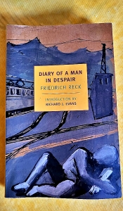
GERMAN WRITER FRIEDRICH Reck (1884-1945) was conservative politically, but not a supporter of Adolf Hitler. In fact, he hated the dictator, the Nazi regime, and what it did to bring about the downfall, morally and materially, of the Germany he was brought up to love.
From 1936 until his arrest in 1944, he wrote a secret journal, which he had to keep hidden from all eyes. The journal, “Diary of a Man in Despair” was discovered in 1947, when it was first published. Each of its superbly written entries charts the gradual decline of Germany, its people, the increasing immorality of the population, and its morally corrupt rulers.
Reading Reck’s book it is a frightening experience. It describes things that are not too dissimilar to what is happening in today’s political climate. And in the context of contemporary life in many continents, it can be read as a chilling warning. Reck’s account provides a good idea of what could happen if people believe the lies and promises of populist leaders, then elect them, and after that, fail to resist their megalomaniac, psychotic ideas and actions.
I discovered a copy of Reck’s book in a second-hand bookshop, and after beginning to read it, I found it difficult to put it down.
Adam Yamey derives great enjoyment from his many travels in India. His forthcoming book (now being edited), “ROAD TO HEAVEN: A passage through India” will transport you on a journey that includes his recent adventures in Karnataka, Maharashtra, Rajasthan, Gujarat, Madhya Pradesh, Kerala, and Tamil Nadu.
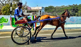
On a highway in Tamil Nadu
Adam will not only describe what he saw and experienced on his tour in late 2025 and early 2026, but he also includes accounts and observations of the places he visited made by earlier visitors (for example, the Emperor Jahangir and the author EM Forster). In addition, he will provide the reader with much information about the formerly British colonial (now ‘elite’) clubs of India, institutions which are barely mentioned in most travel books about the country.
As for ‘The Road To Heaven’ mentioned in the title, you can discover much about it and a host of other attractions and places of interest by reading Adam’s book, which will illustrated with his photographs and some maps. Adam is hoping that the book will be published within a few weeks.
WAS SIR ROGER Casement (1864-1916) a hero, or a traitor, or maybe both? At first a faithful servant of the British Empire, he later conspired against it, promoting the struggle for Irish Independence. After reading “A Rebel and a Traitor” by Rory Carroll, you might possibly be able to decide whether Sir Roger’s intriguing life was heroic or treacherous.
Carroll’s detailed biography of Sir Roger is highly researched and fast-paced. It reads like a thriller, and is an appropriate account of Casement’s complex, thrilling life. The book explores the revolutionary movements in early twentieth century Ireland as well as Casement’s attempts to assist them.
I recommend this book both to those who are interested in the history of Ireland and to those who enjoy exciting tales … in this case a fantastic but true one.
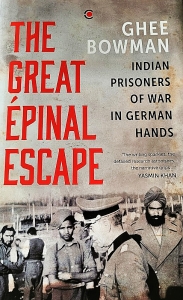
DURING WORLD WAR II, many Indian soldiers fought with the British in North Africa and on many other battlefronts. Vast numbers of allied soldiers were taken prisoner by the Germans in North Africa, and these prisoners of war (‘POWs’) included several thousand Indians. The POWs were taken first to Italy, and then to prison camps in German occupied territory. One of the prison camps that contained many Indians was in the French town of Epinal. In May 1944, allied aircraft heavily bombed the town as part of a programme to damage French the railway system that was being used by the Germans. During this attack, the camp housing the Indians was badly damaged, and many Indian POWs escaped. At least 500 of them found their way to safety in Switzerland, and a few fought with the French resistance. This almost forgotten episode is described in “The Great Epinal Escape”, a book written by Ghee Bowman (1961-2025).
The book details how and where the Indians were taken prisoner; who they were; their journeys from Africa to Epinal; and their lives in the camps. Then, in meticulous detail, it recounts how the escapees found their way to freedom in Switzerland and the help they received from French people on their difficult journeys. This assistance was given by ordinary people, who knew that if they were discovered to be helping escaped POWs, they would face horrendous punishments, including execution.
Bowman’ scholarly but extremely readable book is the only account in English of this great escape story. Whereas the daring escapes of British POWs from German prison camps have been related in books and films, the Epinal escape, probably the greatest escape of POWs during WW2, seems to have been ignored both by British and Indian historians. The reasons for this are discussed in Bowman’s final chapter.
I bought my copy of this book about an almost forgotten episode during WW” in Bangalore (India), and I have enjoyed reading it.
AT PRESENT I AM WRITING another book about travels in India. It describes a journey we made through the following Indian states: Karnataka, Maharashtra, Rajasthan, Gujarat, Madhya Pradesh, Kerala, and Tamil Nadu. During this journey we travelled along a road in Gujarat called THE ROAD TO HEAVEN.
My working title for the book is “ROAD TO HEAVEN AND A PASSAGE THROUGH INDIA”.
Without having read the as yet unfinished book, is this a title that would make you consider reading it, OR CAN YOU SUGGEST A BETTER TITLE?
If I use your suggested title, I will, of course, acknowledge your help.
CURRENTLY MANY MUSEUMS in the ‘Western World’ are pondering over the idea of returning some of their exhibits to the territories from where they were obtained. A controversial example of this quandary are the fragments from Athen’s Parthenon, which are known as the Elgin Marbles.
From 1899 to 1905, Lord Curzon was the Viceroy of British India. In her book “Finding Forgotten Cities”, Nayanjot Lahiri describes how Curzon was concerned about preserving and conserving India’s many archaeological and historical sites, and promoting the work of archaeologists in what was to become the Archaeological Survey of India (‘ASI’). Concerning artefacts removed from India, it was Curzon who arranged for some ancient artefacts to be returned from the British Museum to where they came from in India. The most important thing that Curzon did in relation to Indian archaeology was to appoint the archaeologist John Marshall (1876-1958) to supervise and plan archaeological activities within the Indian subcontinent. It is Marshall and his highly trained colleagues including many Indians such as Rakhaldas Banerji, DR Bhandarka, KN Dikshit, and DR Sahni, who are important protagonists in Lahiri’s story about how the extensive remains of Harrappan (or Indus Valley) civilisation came to be discovered. The book also includes much information about the Italian archaeologist Luigi Pio Tessitori (born 1887 in Udine, Italy, died 1919 in Bikaner, Rajasthan), whose discoveries eventually contributed much to the unravelling of the mystery of Harrapan civilisation.
Apart from the above-mentioned, Lahiri describes the lives and archaeological work of a whole host of other people working in India. She describes how the earlier archaeologists were fixated on finding remains of places mentioned in early texts including the Vedas, classical author’s histories of Alexander the Great’s incursions into the Indian subcontinent, Buddhist and Jain sources, and accounts by early Chinese travellers in India. When the remains of what is now recognised as the very old Harrapan civilisation (as early as about 3000 BC) began to be discovered, it was gradually realised that these were not compatible with the stories written in the ancient texts. Although at first nobody knew the age of these findings, the fact that they were discovered deeper beneath the ground than the artefacts that could be dated, Marshall and his colleagues believed that they had stumbled on remains from a time far earlier than had been hitherto discovered by archaeologists in India. Amongst these and at various different locations, seals inscribed with pictograms or symbols began to be discovered. Later, these seals became important in dating the Harrapan civilisation.
Lahiri’s well-documented, scholarly account reads like a thriller. Not only does she relate the story of the discovery of the Harrapan civilisation and the archaeologists who found it, but also she tells of the difficulties that Marshall encountered ensuring that the ASI was adequately funded. And she tells of the remarkable way that the ageing of the civilisation became possible after Marshall had published his findings with many illustrations in the widely read, non-scholarly Illustrated London News in 1924.
I never believed that I would read a book about archaeology and find it un-put-downable, but Lahiri’s fascinating book was just that. It is a book that should interest both archaeologists and lay readers. I began reading it soon after revisiting one of India’s major Harrapan sites, that at Dholavira in Kachchh (Gujarat), and I am pleased that I did.
I AM AWAITING the arrival of a proof copy of my NEW BOOK about exploring lesser-known places in England to arrive from the printer.
After I have checked it for quality issues, it will soon be available for you to read.
SO, WATCH THIS SPACE!
A little introduction to the forthcoming book:
TRAVEL THROUGH ENGLAND FROM ABBEY WOOD TO ZENNOR, passing on the way places such as Abingdon Piggotts, Barcelona, Come-to-Good, Freshwater, Indian Queens, Little London, Long Melford, New York, Outgate, Queen Camel, Six Mile Bottom, and Veryan.
In this book, Adam Yamey describes a collection of mostly lesser-known places in England, many of which he visited during and after the period when covid19 pandemic restrictions made travelling abroad difficult. On the tour Adam will reveal aspects of life in England from before the Neolithic era to the reign of King Charles III. Adam’s profusely illustrated book contains historical as well as current information, along with personal observations. It will open your eyes to the delights and curiosities of England that can be discovered when you stray off the ‘beaten track’.
HERE IS A BOOK which I have found fascinating. It is “Footpaths in the Painted City” by Sadia Shephard. It was published in 2008. The American born author’s father was an American Protestant, and her mother a Muslim from Pakistan. Her mother’s mother, Nana, converted to Islam when she married in Pakistan. However, early in the book, Sadia reveals how she discovered that Nana was born Jewish in pre-independence India.
What made the book especially interesting is that Nana was born into a Beni Israel family. Nobody is sure of the origins of the Beni Israel Jews, who reside mainly in the western Indian state of Maharashtra. It is commonly said that they are the descendants of Jewish people who left Israel after the destruction of the Second Temple in Jerusalem, and made their way by land and sea to the western coast of the Indian Subcontinent. They have adhered to all the rituals followed by members of other Jewish communities for many centuries. Until some European traveller in India recognised their adherence to Jewish religious ways of life during the nineteenth century, it is said that the Beni Israel community were unaware that they were Jews.
In her book, Sadia tries to discover more about Nana’s life story and the Beni Israel community into which she was born. To do this, the author travelled to both Pakistan and India. Her account of her time in India, investigating what remains of the country’s Beni Israel communities is fascinating and gives the reader a good idea of what a young lady experienced while living on her own for several months in India.
I have greatly enjoyed reading this engaging and moving book, and can recommend it to anyone interested in Judaism in India, the Beni Israel community, family history, travel, and any combination of these.
I am at present writing a book about my recent travels in India. I would be most grateful if you would read through this draft of my opening paragraph, and send me your observations about it. Would you want to read further? The paragraph is beneath this photograph taken in Jaipur.
Early one morning in February 2025, our British Airways Boeing 777 jet began moving away from the oddly designed, apparently ‘eco-friendly’, Terminal Two at Bangalore’s International Airport. As the aeroplane taxied smoothly towards the runway, I watched the parched airport terrain and its assortment of buildings, some painted with red and white checkerboard patterns, slipping past. Then with a certain suddenness heralded by an increase in the noise of our jet engines, we accelerated along the runway. Soon, we became detached from the soil of India. As the aircraft rose higher and higher, random memories flashed through my mind. These included eating laal maas on a rooftop in Jaisalmer; a distraught restaurant owner in Jodhpur; a Dutch cemetery on the Coromandel Coast; hawkers wandering up and down a railway carriage in West Bengal; riding through Bangalore in a Jesus autorickshaw; blessing a newly married couple in Pondicherry; tasting homemade nolen gur in Murshidabad; attending an aarti on the Ganges; eating ravioli in Auroville; the ghost of Tipu Sultan; and much more. After flying over the west coast of India, all these experiences and a whole host of others that we had enjoyed during our 88 day stay in India (between November 2024 and February 2025) became, like the Indian coastline over which we flew, distant memories which I hope will remain etched permanently in my mind. In the pages of this book, I will revive these and a whole host of other reminiscences and explore them in detail. I want my readers to enjoy and understand what we experienced during our almost three month long stay in India.
WITH ABOUT SIX hundred and forty pages of text, this book published in 2024 covers a lot of ground. Much of what Tripathi writes about Gujarat and the Gujaratis is fascinating. However, the author’s definition of who is a Gujarati may differ from that of many others. His definition of a Gujarati is anyone whose mother tongue is Gujarati. Thus, he includes groups such as the Parsis, the Bohras, and the Khojas. None of those groups, all of whom have Gujarati as their mother tongue, would usually describe themselves as Gujaratis, even if they reside in Gujarat. Although Kachchhis generally speak Kachchhi amongst themselves, most speak Gujarati as well, but most of them would disagree with Tripathi’s calling them ‘Gujaratis’. By using his definition of a Gujarati, the author was able to include many people, who would not have described themselves as Gujarati, in his book.
The book is a mine of information about people that the author describes as being Gujaratis. Much of this information is fascinating, but there were occasional passages that I felt should have been shortened or omitted. Although Tripathi deals a lot with some of the sadder aspects of life in Gujarat, he also injects humour into his text. However, he notes that Gujaratis are proud of Mahatma Gandhi, a Gujarati, but in recent years, they seem to be forgetting what he stood for.
I am glad that I read this book, but would advise those planning to read it that it is more of an encyclopaedia than a portrait of the Gujaratis. Tripathi covers a great deal, but I felt that at the end of it, my understanding of the soul of Gujarat and its people had only increased by a small amount.