IN THE FIFTEENTH century, the Portuguese made an important set of discoveries, which were kept a closely guarded secret. These discoveries brought great wealth to Portugal. The Portuguese navigators found routes from Portugal to India via the Atlantic Ocean and the Cape of Good Hope. By using these, they were able to transport spices and other valuable commodities from Asia to Portugal directly. Prior to the discovery of this sea route, goods from India and further east arrived in Europe via Egypt and the former Ottoman Empire. This overland route undoubtedly added various middle-man costs to the goods.
Once the Portuguese began sailing in the Indian Ocean, they successfully created a monopoly over trading in this area. However, after a period of uninterrupted use of the Indian Ocean, competition arrived in the form of mainly Dutch and British trading vessels.
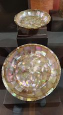
Madeira was one of the places that the early Portuguese ships called in at during their voyages. This was brought home to me during a visit to Funchal’s superb Museum of Sacred Art. In two of its rooms we saw religious artefacts – sculptures and two mother of pearl bowls – which were labelled as having come from India. There were others that came from ‘Portuguese Asia’. One item, a beautiful inlaid tortoise shell box, came from Japan.
Unlike the religious sculptures we have seen in old Portuguese churches in Goa, which often feature Indian looking faces, those in the museum had European facial appearances. An exception is a 16th century carved panel depicting St Francis Xavier asleep on the Island of Shangchuang. He is accompanied by two saints – one Indian and the other Chinese.
Seeing these beautiful old sculptures and other objects, which were made in Asia and then brought to Madeira, helped make the history of Portugal’s former pioneering navigational achievements a little more vivid for me.