I ENJOY ENTERING CHARITY SHOPS (shops selling used goods to raise money for good causes) to browse the books they have on sale. Even if I do not find anything of interest or buy anything, I find these visits both satisfying and therapeutic. Yesterday, to satisfy my craving for the browsing experience, I stepped into a local charity shop which I have entered many times before, often with only a day or two’s interval between visits: usually finding that the stock of books has barely changed, and not expecting to find anything worth purchasing. This time, my gaze fell on a large old book on a shelf. What caught my eye was the title on its wide spine: “Gazetteer of India”. Because I have a great interest in India, I always look at books about the country and this was no exception.
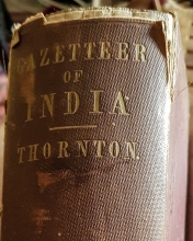
The book has 1015 pages of text printed in a tiny font. Eagerly, I looked for its date of publication and to my great delight I discovered that it was published in 1857. For those who are not familiar with it, this is the year when the so-called ‘Indian Mutiny’, or, as it is known nowadays, the ‘First War of Independence’, began on the 10th of May. The book’s full title “A Gazetteer of the Territories Under the Government of the East-India Company and of the Native States on the Continent of India” was soon to become out of date because following the ending of the ‘Mutiny’ in 1858, the British Government took over the ruling of India from the East India Company.
The book by Edward Thornton (Esq.) was published in response to the desire of the General Courts of the East-India Company to have “… an authentic Gazetteer of India [that] should be offered to the British public in a cheap and convenient form…”. Thornton had already published a four volume “Gazetteer of India” in 1854. The book I found yesterday contains much of the information that was published in the multi-volume edition. The book that I purchased is an original edition, which is rarely offered for sale in the second-hand book market. A facsimile edition was published by the British Library in the 21st century. Fortunately for me, whoever had priced my copy had no idea of its true worth, which is unusual because often those who run charity shops often check the market prices of old books.
Edward Thornton (1799-1875), the author of the gazetteers is, apparently, often confused with the better-known Edward Parry Thornton (1811-1893), who was an administrator in India where he lived on and off between 1830 and 1862. ‘Our’ Edward of the gazetteers worked at East India House (which stood in London where today the towering Lloyds building now stands) between 1814 and 1857, where he was head of its Maritime Department from 1847. The Oxford Dictionary of National Biography includes this information about him:
“Among his publications were gazetteers of the territories held by the East India Company and the ‘countries adjacent to India on the North-West’, and a six-volume History of the British Empire in India (1841–5). He was also responsible for entries in the eighth edition of the Encyclopaedia Britannica on Indian subjects, which have also been attributed to Edward Parry Thornton. This Edward Thornton died at 1 Montpelier Street, Brighton, on 24 December 1875.”
You can rest assured that I will not be reading all 1015 pages of my new ‘treasure’, but I will enjoy dipping into it to read about places I have visited or hope to visit in the future. One of the first places I looked up was Tranquebar in Tamil Nadu, which we visited in February 2020. Formerly, it had been a Danish colony in India. Thornton wrote:
“ … The settlement of Tranquebar was ceded to the British government in 1845 by the King of Denmark, for a pecuniary consideration … the superiority of the British over Danish administration is attested by the growing prosperity of the district, and the large increase in the amount of the government revenue…”
This “government revenue” did not benefit the British in general but rather the coffers of the East India Company.
Of Bangalore, which I have visited more than 50 times in the last 26 years, Thornton wrote a whole page that includes the following:
“… The town is tolerably well built, has a good bazaar, and is inclosed [sic] by a wall, a ditch, and a broad fence of thorns and bamboos…”
Thanks to my friend, an excellent guide to Bangalore, Mansoor Ali, I knew of the existence of the fence (hedge) of vegetation mentioned in the quote but did not realise it was still in existence as late as 1854/7. This hedge is marked on some maps of Bangalore created during the 19th century. According to a map dated 1800, the circular hedge surrounding Bangalore ran through present day Yeshvantpur in the north. Kengery in the west, and almost at Madiwala in the south east. I have no idea when the hedge disappeared, but it was clearly after the time when Thornton knew of its existence. I look forward to much more delving in my latest literary acquisition.
Finally, my copy of Thornton’s book has an ex-libris sticker that bears a coat-of-arms and the name ‘John Harrison’. Harrison is a common family surname. A quick look at Harrison coats-of-arms displayed on Google reveals that the crest in my book is similar but not identical to that of the “Yorkshire Arms” of the ‘James River Harrisons’, which originated in the north of England. They settled on the James River in Virginia in the 1630s. If my book was once owned by a member of that family, I wonder how it ended up on a shelf in a charity shop in West London.