PHILIP’S NAVIGATOR BRITAIN is a detailed (1 ½ miles to the inch) road atlas covering England, Scotland, and Wales. It is extremely useful for finding one’s way through Britain’s maze of narrow country lanes if, like us, you do not make use of GPS systems. One of the many features of the maps in this atlas is that it marks old buildings and other sites of interest in both towns and deep in the countryside. Recently (June 2021), we were driving around in rural Wiltshire, having just visited the small town of Bedwyn when I spotted that there was an old chapel nearby, close to the hamlet of Chisbury.
The area in which Chisbury is located is the site of an ancient hill fort in which archaeologists have found artefacts from the Palaeolithic era, as well as the Neolithic and Bronze Ages. The fort, whose earthworks are still discernible, was later used by the Romans. Long after the Romans had left England, the manor house of Chisbury was built within its site.
In the 13th century, the Lord of Chisbury Manor built a ‘chapel of ease’, St Martin’s, close to his manor house. According to Wikipedia, such a chapel is:
“…a church building other than the parish church, built within the bounds of a parish for the attendance of those who cannot reach the parish church conveniently.”
The chapel of ease at Chisbury was built to serve the household of the Manor House as well as villagers nearby, to save them having to travel to the nearest parish church which was in Great Bedwyn.
In 1547, during the Reformation of The English Church, the chapel, like many other places of worship in Henry VIII’s realm, ceased to be used. Instead of being demolished, as so many ecclesiastical buildings were at that time, the chapel was re-used as a barn. The barn continued to be used over several centuries until 1925, when it was designated a building of historical importance. Now, it is maintained by English Heritage. This re-purposing of a place of worship reminded me of what I saw when I visited Albania in 1984. At that time, religion of any sort had been made illegal by the Stalinist regime led by Enver Hoxha. Mosques and churches had either been demolished or re-purposed as sports halls, cinemas, and for other non-religious uses.
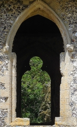
The chapel of Chisbury is beautiful. The glass has been long lost from its windows. Trees can be seen from within the chapel through its carved stone gothic windows. The ceiling of the chapel is timber framed, but I suspect that these are no longer the original timbers. The roof is thatched. The floor is at two levels, higher at the west end than the east. Steps lead from one level to the next. The two levels might reflect the fact that the chapel is built on a steeply sloping hill.
On the inside of the west wall of the building, close to the way into the chapel, there is a faded red painted circle enclosing a cross. Symbols like this were painted on to the walls of buildings during the consecration ceremonies of building about to become churches. What you can see in the chapel at Chisbury must have survived many centuries. Maybe, it has been touched up from time to time.
It is written that Jesus Christ was born in a kind of barn surrounded, as the story goes and many artist have depicted, by farm animals. I wonder whether this went through farmworkers’ heads as they used the former chapel as a barn for a variety of agricultural purposes.
Had it not been for builders working nearby, the chapel would have been silent except for birdsong. I am glad we made the small detour to see this delightful relic of mediaeval life in England.