WE VISIT DOVER Street in London’s Mayfair frequently to view exhibitions at the commercial art galleries along it. Laid out in the late 17th century, the street is named after Henry Jermyn (c1636-1708), 1st Baron Dover, who was a member of the syndicate that developed the area in which it is located.
Despite having walked along this street countless numbers of times, it was only this September (2024) that we spotted the entrance to a narrow alley way on the west side of the street between numbers 41 and 43. The alley is called Dover Yard. The first 12 yards of this passageway are covered by a high barrel vaulted, brick-lined ceiling. Then, after a short stretch open to the sky, one enters a wide yard made attractive with plenty of plants.
The yard itself is surrounded by modern buildings. In the 1970s, the yard, which has existed since the 18th century, was bought by developers and used as service area and parking lot (www.ianvisits.co.uk/articles/londons-alleys-dover-yard-w1-64590/). It was redeveloped recently, and is now flanked by the elegantly designed Nightingale coffee bar and restaurant (part of 1 Hotel Mayfair) on the north side, and Dovetail, a Michelin-starred restaurant, faces it. West of the wide yard, there is another narrow alleyway leading to Berkely Street. It has become a peaceful, almost hidden oasis in the heart of a busy part of Mayfair not far from Piccadilly.
As is often the case when revisiting places we thought we knew well in London, we come across places like Dover Yard, which we have passed often but never noticed. Although we did not try it, the Nightingale looks like it would be a very pleasant place to stop for refreshment.
I HAVE VISITED the famous Grand Canyon in the USA, and seen it after a heavy snow fall. I have also seen a fabulous canyon in New York State, a few hours drive away from Buffalo. However, it was not until the first of February 2023, that I heard of, and then visited a grand canyon in Kutch, which is now part of the Indian State of Gujarat.
The canyon, named Kadiya (aka Kaliya) Dhro, is 73 Km north of the coastal city of Mandvi, and 33 Km northwest of Bhuj. Although the canyon is many, many thousands of years old and had been known to locals forever, its existence only became widely known in 2020. It was then that Varin Suchday, founder of the Kutch Travel Club stumbled across it. He had heard it discussed by local tribes people, whilst he was assisting them during the covid19 crisis, and with considerable difficulty, he managed to find it in the midst if the poorly mapped, arid semi-desert countryside.
We drove from Mandvi to a dusty parking area about 4 Km from the canyon. Several battered jeeps wait there to take visitors to the site. We boarded a well-worn Mahindra jeep, which was driven by a young fellow who looked to be about 15 years old; his voice had not yet broken. He drove us skilfully along sandy tracks strewn with rocks, precarious slopes, potholes, and other hazards. We held on to the Mahindra’s metal structural elements to avoid being thrown out of the constantly jolting and tilting vehicle, which had neither doors nor seatbelts. The tortuous track threads its way across dried up beds of streams; over boulders and sharp projecting stones; and past branching cacti and thorny bushes. Every now and then, other faster jeeps overtook us on this perilous, winding path. Other vehicles travelling in the opposite direction either waited for us to pass or vice-versa. After about thirty minutes of this exciting journey, we reached a parking area near the canyon.
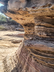
The canyon is in the district of Ulat village, which we did not visit. A fast-flowing river, in which our driver spotted a crocodile, has over the millennia formed the canyon. Like the Grand Canyon, but far smaller, its walls are horizontally striated. The striations vary in colour. Here and there, you can see roundish rock formations that look like huge mushrooms. Their stalks are also striated. Parts of the riverbed that are not submerged are rocky platforms with patterns of grooves resembling crazy paving. The striations result from the alternate layers of shale and sandstone combined with the effects of sea air (for more detail, see: https://zeezest.com/travel/kaliya-dhrow-in-kutch-is-a-geological-wonder-to-behold-zee-zest-1054).
We visited the canyon on a Wednesday morning during the school term, so the place was not crowded. I have been told that on Weekends and during school holidays, large crowds of people come to view the interesting geological formations. We saw less than twenty other tourists, mostly Indian. Many were standing precariously on the rocks close to the water, posing for pictures probably destined to appear on Facebook and/or Instagram. I took many photographs of this lovely place.
I am extremely grateful that my wife’s cousin, who lives in Mandvi, arranged for us to visit the canyon, a geological jewel hidden deep in the Kutch desert. Although far off the ‘beaten track’, it is a highly worthwhile destination. A word of advice: the ride in the jeep is not a good idea for those with unhealthy backs!
ABOUT 26 YEARS AGO, we had lunch in a state run hotel near the archaeological site at Hampi in Karnataka. On the way to a toilet, I had to pass some of the hotel’s bedrooms. Each was closed with a padlock. I do not know why I bothered to look at a lock carefully, but I am glad that I did. The lock was manufactured by the Hitler lock company. I could not believe my eyes, and I took a closeup photograph of it.
Since seeing that lock, I have visited India about 50 Times. On every visit, I have spent some time wandering around markets and bazaars in many Indian towns and cities. At every market I have kept an eye open for Hitler locks, but never found even one of them. When I have asked lock sellers if they stock them, the majority of them look blankly at me.
Today, the 9th of December 2023, we enjoyed a journey on a crowded local bus in Goa. We travelled from Panjim to the town of Mapusa to experience its large market. After wandering around for a few minutes, I noticed a small stall selling locks.
As I have always done at other markets I stopped to examine what locks were on sale. To my great surprise, the vendor had some Hitler padlocks. They were available in three sizes. I bought the middle sized version.
The locks are manufactured by Hitler Lock Enterprises,which is located in Aligarh in Uttar Pradesh State. I can only guess that the name Hitler was chosen because someone must have regarded him as being at least as strong as the locks they produce. Why they chose Hitler, rather than strong personalities such as Hanuman or Hercules, puzzles me.
After making my purchase and some others (mainly clothes), we ate superb seafood in the St Francis Xavier restaurant in the centre of the market. On our way back to the bus station (bus stand), we passed another lock seller. I noticed that he also had Hitler locks for sale.
Hitler is a brand name that would not sell well in most parts of the Western World. Judging by the fact that so far I have only found these locks in Mapusa, maybe it is not a trade name that goes down particularly well in India. However, Adolf’s book “Mein Kampf” is available in most Indian bookshops. Although its author was fixated on Aryans, he did not have a soft spot for Indians, as you will discover in the book “Hitler and India”, recently written by Vaibhav Purandare.
BEFORE I LEARNED TO drive, I began visiting a friend who lives in the heart of the Cornish countryside, a few miles away from Bodmin. I used to travel by train from London’s Paddington to Bodmin Parkway station, which is a short distance away from the town of Bodmin. My friend, Peter, used to collect me from this small station and drive me to his family’s smallholding deep in the countryside. After passing my driving test in 1982, I began driving to Cornwall. Today, the 10th of October 2022, we dropped off our daughter at Bodmin Parkway station to catch a train to London. This was my first visit to the small station since the early 1980s. It brought back memories of my early visits to see Peter and his family.
Bodmin Parkway station
I met Peter through mutual friends. We clicked. In the years following our first meeting, we saw each other regularly, considering how the great the distance is between our homes. On one visit to Peter’s home, I spotted a photograph of his mother, and remarked that her appearance reminded me of my mother. We thought nothing of this at the time.
In the late 1990s, I began researching the history of my parents’ families. An enquiry to a relative, who lived in Zimbabwe led me to contacting another relative, who worked for New Zealand’s diplomatic service. He got in touch with me and was able to supply information that was missing on one of the family trees connected to my mother’s family. I looked at what he had sent me, and my eyes nearly popped out of my head. For, amongst the people listed in that branch of the family tree were Peter and his children. It turns out that Peter is both my fourth and fifth cousin. The reason for this double relationship is that my mother’s parents were second cousins once removed; they shared a common ancestor. So, it turns out that not only is Peter a good friend but also a cousin. It is interesting that although Peter and I were already good friends, knowing that we are related has enhanced our relationship. Standing on the platform at Bodmin Parkway, waiting for our daughter’s train to arrive, brought back memories of my first encounters with Cornwall, a good friend and his mother’s photograph, and my discovery that he is part of my family.
THE DISCOVERY OF Canada by Europeans is not usually at the forefront of my mind, especially just after an airflight landing in Venice. Yet when we disembarked from the waterbus that carried us from Marco Polo Airport to the city, I noticed a building that surprised me at the south end of the Via Garibaldi (in the Castello ‘sestier’ of Venice). It has one plaque commemorating Giovanni Caboto (c1450-c1500) and his son Sebastiano Caboto (c1450-c1557). Giovanni is better known (to me) as John Cabot. I had no idea that Cabot, the ‘discoverer’ of Newfoundland was from the Italian peninsular. Sebastiano was also a maritime explorer. His most famous work was done in South America.
Cabot(o) lived here in Venice
Giovanni Caboto’s birthplace is unknown, but is likely to have been in the Province of Genoa. By 1476, he had become a Citizen of Venice. He was a trader there. Getting into financial difficulties, he left Venice for Spain in the late 1480s. After seeking financial support for a trans-Atlantic expedition, which never happened, he set off for England in 1495. Cabot, as he became known in England, went to Bristol. From that seaport, he led at least three expeditions to explore the east coast of North America. During these voyages, he set foot on what is now called Newfoundland and probably also on parts of what is now Nova Scotia. One of his later expeditions is believed to have been one of the earliest attempts to discover a Northwest Passage.
Cabot received a reward for his services from England’s King Henry VII. Where John Cabot died is uncertain. It might have been during his last expedition to North America during the period 1498-1501, but no one knows for sure whether he died at sea, or in North America, or after his expedition had returned to England.
A monument on the house in Via Garibaldi, which was placed in 1982 by the Canadian Province of Newfoundland, records that John’s discoveries in 1497 were made with his son Sebastiano. The house that bears this monument (written both in English and French) and another one in Italian, is said to be the house where John Cabot lived in Venice. From many of its windows, the great explorer would have had a good view of the lagoon and the quays, where trading vessels might well have been loaded and unloaded.
Our rented apartment was on a narrow street leading off the Via Garibaldi. I was pleased to see that this is close to a narrow alleyway called Ramo Primo Caboto.
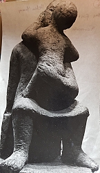
MY LATE MOTHER (Helen Yamey: 1920-1980) trained as a commercial artist in Cape Town (South Africa) before WW2. In 1948, she came to London to marry my father. In London, she painted and, according to my father, took lessons from the great Stanley Spencer (1891-1959). Around the time when I was born (1952), my mother began making sculptures. The first of these was a terracotta mother and child. Maybe, she was depicting herself with me in her arms. By the 1960s, she was working in the sculpture studios of St Martins School of Art, which was then near Foyles bookshop on Charing Cross Road. There, she was in the company of artists such as Anthony Caro, William Tucker, Philip King, and William Turnbull. At least one of these now famous artists taught my mother how to weld and solder.
My mother exhibited her works in important art galleries at least twice. In late 1961, she exhibited at the Institute of Contemporary Art in a show called “26 young Sculptors”. In 1962, she exhibited sculptures at the Grabowski Gallery, along side works by Maurice Agis and David Annesley. Although she sold a few of her creations, she did them more for pleasure than for profit.
My mother was a perfectionist. She destroyed much of what she created. However, at some time during the 1960s, she had a series of professional photographs taken of some of her mainly abstract works. These were kept in a yellow Kodak photographic paper box in a drawer in our home in Hampstead Garden Suburb. As a teenager, I used to look at them occasionally and wonder what became of some of the creations recorded in these photos.
My mother died in 1980 and my father remarried 11 years later. After remarrying, he and my stepmother moved from our home in Hampstead Garden Suburb to another house (near Primrose Hill). After the move, I used to ask him what had happened to the photographs of my mother’s sculptures and other family photos. Each time I asked, he would say that they were stored somewhere, possibly in the garage of his new home. After a while, I gave up hope of ever seeing these pictures again because it was clear to me that Dad had little or no interest in these photographs and in addition he could not imagine why anyone else would find them interesting. My father died, aged 101 and 6 months, in 2020. What with covid19 and its associated problems, we did not see his widow, my stepmother, again until recently this year (2022).
When, at last, we met her, she arrived carrying a plastic carrier bag, which she handed to me. To my great delight, it contained the box of photographs described above and another filled with family photographs taken mainly in the late 1950s. My stepmother told me that she had found them when she was sorting things in the garage of the house where she and my father had lived.
The photographs of my mother’s sculptures all bear the name of the photographer: Joseph McKenzie, ARPS (95 Blenheim Gardens, Wallington, Surrey). According to Wikipedia, Joseph McKenzie (1929-2015) is regarded as “father of modern Scottish photography”. More relevantly in the context of my mother’s works, he taught photography at the St martins School of Art.
Some of the photographs have notes written on their backs. The handwriting is my mother’s. One of the pictures, that of the mother and child has the words: “my first ever sculpture, terracotta, mother and child, 24””. Some of the other photos have information about the size and the material of the work depicted.
About 10 years before she died, my mother became disillusioned and practically gave up making sculptures. Although she made a few abstract images in pen and ink and a few carvings in alabaster, her abandonment of sculpture making as a full-time activity left a great hole in her life.
I have taken pictures of the photographs, and they can be seen on:
Hampstead is one of the highest places in London. There, the heavens are vast and wide. Beneath this expanse of sky is an area with an eventful past and a vibrant present. This book takes a fresh look at the locality and shows that Hampstead is richly imbued with historical memories and has been home to a multitude of fascinating and noteworthy people. Many books have been written about Hampstead. Doubtless, there will be more. This one is different. It looks at Hampstead from unusual as well as familiar viewpoints and gives the reader a richer appreciation of what makes the place both delightful and intriguing. This volume explores a wide variety of subjects, familiar and obscure, as well as some which have never been described in other books about the locality. Here is a fresh and at times quirky look at this place on a hill, one of London’s treasures: a district, which is familiar to many people, yet full of surprises. Although the bulk of this book is about Hampstead, there are also sections describing some of its environs.
By reading this book, you can find out why John Constable, Samuel Johnson, Boy George, Mohammed Ali Jinnah, Mahatma Gandhi, Peter Sellers, Henry Moore, Maxim Litvinov, General de Gaulle, Stanley Spencer, Thomas Masaryk, Lee Miller, Agatha Christie, Jim Henson, Ian Flemming, Ernő Goldfinger, and many others, both famous and familiar, were all connected with Hampstead.
The book has several sections: 1. a brief survey of Hampstead’s general history and geography. 2. an introduction to Hampstead’s main thoroughfares with some reminiscences of the area as it was during my youth. 3. the largest section of the book is a collection of chapters about various aspects of Hampstead’s past and present. Recently, a friend of mine bemoaned the fact that Hampstead High Street and Heath Street are lined with branches of shops and cafés that can be found all over London. He is right. So, if you wish to capture the true character of Hampstead, you need to stray into the side streets and explore, which is what I hope this book will stimulate you to do. 4. The last few sections of the book deal with some places of interest near to Hampstead: Primrose Hill, North End, Golders Green, and Highgate.
TABLE OF CONTENTS
PREFACE … 7 INTRODUCTION: OH NO, NOT IN HAMPSTEAD … 7 SOME GEOGRAPHY AND HISTORY … 13 HEATH AND HIGH STREETS WITH SOME MEMORIES … 25 SATURDAY STROLLS … 25 PERRINS LANE, THE EVERYMAN, AND LOUIS … 34 DISCOVERING HAMPSTEAD … 41 A HOUSE ON HEATH STREET AND THE KIT CAT CLUB … 41 A CHURCH ON HEATH STREET … 45 FLASK WALK AND THE HAMPSTEAD SPA … 46 MORE ABOUT THE SPA … 56 THE VALE OF HEALTH … 60 POETS AND THE VALE OF HEALTH … 70 FRENCH CONNECTIONS AND ST MARYS ON HOLLY WALK … 76 ARTISTS IN HAMPSTEAD: ROMNEY, CONSTABLE, AND OTHERS 84 MODERN ARTISTS AND THE ISOKON … 95 BOLSHEVISM AND HEATH STREET … 109 A SINGER AND A PHILOSOPHER ON BRANCH HILL … 114 JUDGES WALK … 118 WHITESTONE POND … 122 EAST HEATH ROAD AND SOUTH END GREEN … 126 SIR HARRY AND ROSSLYN HILL … 137 PILGRIMS LANE AND MORE ON ROSSLYN HILL … 143 NEW END, CHOLERA, AND GROVE PLACE … 150 FITZJOHNS AVENUE AND SWISS COTTAGE … 155 SHEPHERDS WELL … 171 CHURCH ROW … 174 GRACIE FIELDS, FROGNAL WAY, AND FROGNAL … 179 WEST HEATH ROAD AND PLATTS LANE … 187 WEST HAMPSTEAD … 193 SHOOT UP HILL … 198 PRIMROSE HILL … 201 NORTH END AND GOLDERS GREEN … 211 NORTH END AND GOLDERS HILL PARK … 211 POETS AND GOLDERS GREEN … 228 LIFE AND DEATH ON HOOP LANE … 232 HIGHGATE … 241 CODA … 273 SOME BOOKS CONSULTED … 275 ACKNOWLEDGEMENTS … 278 INDEX … 279
KEEN READERS OF NOVELS by Georgette Heyer (1902-1974) will have come across the name ‘Hitchin’ in several of her stories. For example, in “The Foundling”, Belinda sighs, and then says:
“She went to a place called Hitchin, but I don’t know where it is, and I only recall it because it sounds like kitchen, and I think that is very droll, don’t you, sir?”
She receives the reply:
“But Hitchin lies only a few miles from here! I daresay no more than six or seven, perhaps not as much! If you think you would like to visit this friend, I will take you there tomorrow! Do you know her direction?”
Later in the story, there are frequent mentions of Hitchin and a ‘Sun Inn’ in the town. There used to be an inn with that name on Sun Street, where currently, there is a Sun Hotel. In another novel, “The Reluctant Widow”, Hitchin is the name of the landlord of an inn, ‘The Bull’ in Wisborough Green, a village in West Sussex.
Old world in central Hitchin
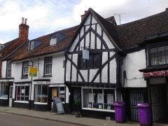
It is only in recent years that I have begun to read the wonderfully crafted historical novels by Heyer, but I was aware of Hitchin even as a young child. In those now far-off days, when I lived near Golders Green in north London, I was a collector of bus and train maps and an enthusiastic observer of buses. One of the buses that passed through Golders Green and along Finchley Road was the Green Line route number 716 that travelled all the way from Chertsey in southwest London to … you have probably guessed … Hitchin, far north of London in Hertfordshire. It was only today (11th of May 2021) that I finally got to visit Hitchin. I had read that it has a picturesque historic town centre and what we found surpassed all expectations.
A 7th century document states that Hitchin was the centre of the Hicce people, ‘hicce’ being Old English for ‘the people of the horse’. By 1086, when the Domesday Book was compiled, Hitchin was described as a ‘Royal Manor’. The town’s name is also associated with the River Hiz (pronounced ‘hitch’ by some), a short stretch of which flows in front of the eastern end of the centrally located St Mary’s Church, which is mostly 15th century with an 11th century tower. Later, the town thrived because of the wool trade; vellum and parchment making; tanning; rope-making; malting; and its coaching inns, such as that mentioned in Heyer’s novel. Hitchin was a staging post for coaches travelling between London and what road signs in the south of England call ‘The North’. The town is not far from the current A1 trunk road. Many of the inns have long since closed, but their picturesque buildings, most of which look mediaeval, or at least pre-Georgian, still stand and can often be identified by the large archways leading from the street into yards behind them. Grain trading was another important activity in the town. Its former Corn Exchange still stands in the Market Square, but its use is no longer what it was built for.
Despite the 20th century improvements in transport links to London, making Hitchin into a convenient place for commuters, the historic town centre contains a remarkably high number of old buildings lining its mediaeval street lay-out. These old throughfares surround the lovely, large Market Square, which like many towns and cities in mainland Europe, was filled with tables and chairs for people to enjoy refreshments from the many eateries that surround it. A covered arcade leads off the square and provides a weather-proof place for refreshments. Nearby, there is a modern market area with stalls with conical roofs. We were fortunate to have arrived on a day, Tuesday, when this market is working.
Our first impression of Hitchin was extremely favourable, but because we had planned to do so much more sightseeing that day, we did not spend nearly enough time there. We hope to revisit this place again soon. I can strongly recommend the Hitchin to anyone who wants to get a flavour of ‘Ye Olde England’ without having to travel too far from London.
WINDSOR CASTLE IS well-known to many people and much visited. However, what came before the castle was built is less known. Recently, we visited the place near Windsor which used to be the home of Britain’s royal rulers well before the Normans invaded the British Isles. Our trip began at the car park close to where the Magna Carta was signed in Runnymede in 1215.
Beaumont House
We slithered through the mud and wet leaves on the path running along the bank of the River Thames from Runnymede to Old Windsor. The path runs past the large gardens of homes along the river and provides views of the occasional barges moored on both sides of the stream. We caught glimpses of a couples of swans but remarkably few other forms of bird life. Birds might have been in short supply, but not aeroplanes. Despite the decrease in air travel that has resulted from the covid19 pandemic, there seemed to be a ‘plane flying low over us every one or two minutes because we were walking beneath the flight path along which aircraft descend as they near Heathrow Airport. The low clouds meant that although we could hear them, we could not see all of the ‘planes.
We left the riverside path after having walked about a mile and followed a footpath to the church of Saints Peter and Andrew on the edge of Old Windsor. This lovely church with a sharp pointed steeple and flint walls is set in a graveyard with many picturesque funereal monuments and a tall redwood tree. The present building was constructed in 1218 to replace an earlier wooden church that was burnt down by French mercenaries in 1215 in response to King John’s recent somewhat reluctant signing of Magna Carta at nearby Runnymede (www.oldwindsorchurch.org.uk/history.html). I do not know who was paying these incendiary Frenchmen and wonder if President Donald Trump might not employ some people to create similar mayhem following his election defeat. Since 1218, the church, which was locked when we visited, underwent various modifications over the centuries including an extensive restoration in 1866 by the architect Giles Gilbert Scott (1880-1960).
Most of the present village of Old Windsor is of little interest to the visitor. However, its history is. Old Windsor existed before the formerly named ‘New Windsor’ or ‘Windsor’ as we know it today. The name ‘Windsor’ might be derived from Old English ‘Windles-ore’ or ‘Windlesora’ (meaning ‘winding shore’). The place now known as ‘Old Windsor’ is recorded in the 9th century Anglo-Saxon Chronicle, an early history of the Anglo-Saxons. During that pre-Norman Conquest era, there was a royal palace at Old Windsor. The old palace continued to be used until the castle, the present Windsor Castle, began to be constructed in the reign of William the Conqueror. According to James Thorne in “Handbook to the Environs of London” (published in 1876), the royal residence at Old Windsor continued to be used, maybe occasionally, until the reign of King Henry I, that is until between 1100 and 1135. The old palace has long since disappeared. Some archaeological remains of the palace were discovered in the 1950s and are kept in the Reading Museum.
We walked from the church to a main road (the A308) along a long road (Church Road) through Old Windsor. Apart from a few mildly picturesque old cottages near the church, it was lined with suburban dwellings lacking in architectural merit. The main road along which we walked back towards Runnymede is appropriately named ‘Straight Road’ because it is straight in comparison to the river that runs its sinuous course close by.
When we reached a short thoroughfare named Ousely Road, we noticed what looked like the gatehouse to a large estate at its far end. We walked up to what was definitely once a gatehouse, and which, to prove it, is named ‘Front Lodge’. Beyond it, a vast lawn ascended a slope towards a large house that was barely visible. By walking a short distance from the lodge, we reached the entrance to the Beaumont Estate on Burfield road to which Ousely Road leads. This estate is currently owned by the De Vere hotel group, but in the past, it had a far more celebrated owner.
The estate, which was originally called ‘Remenham’ after Hugo de Remenham, who owned the land in the 14th century, was renamed ‘Beaumont’ in 1751 by the son of the Duke of Roxburghe. In 1705, the then owner, Lord Weymouth, had a mansion built. It was designed by James Gibbs (1682-1764), who also designed St Martin in the Fields in London and the Radcliffe Camera in Oxford. Sadly for us, in the early 19th century, the building was rebuilt and extended for its then owner, an ‘Anglo-Indian’ (i.e. a ‘Brit’ who had lived and worked in India) named Henry Griffiths, by Henry Emlyn (1729-1815), an architect based in Windsor. The impressive neo-classical portico on the present building was Emlyn’s work.
In 1786, the mansion was acquired (for £12000) by another man who was associated with India, Warren Hastings (1732-1818). Hastings had been the first Governor of the Presidency of Fort William (Bengal) and along with Robert Clive (1725-1774), he was one of the founders of the British Empire in India. When Hastings returned to England in 1785, the House of Commons attempted to impeach him for misdemeanours he was alleged to have perpetrated whilst he was in India. He was eventually acquitted in 1795. During the first three years of his trial, Hastings lived in Beaumont House. In 1789, he sold it to Griffiths, already mentioned.
After several others had owned the estate, in Beaumont became a college, Beaumont College, run by the Society of Jesus and established in 1861. This institution flourished until it was closed in 1967. After becoming a computer training centre and then a conference centre, the estate was acquired by the company that owns the De Vere hotel group. When we wandered into the estate, there seemed to be nothing much happening there.
From Beaumont, it is a short walk to the National Trust Runnymede car park, from which we set off for nearby Datchet, which I will write about separately. If it had not been for the slippery state of riverside footpath, we would have returned along it and thereby would have likely never have come across Beaumont and discovered its interesting connections with British India.