A bridge, canals, and a church in west London

THE GRAND UNION canal meets the River Thames at Brentford. From there, it runs towards the Midlands where it meets other waterways in England’s extensive network of canals, which was built for commerce, but is now used mainly for pleasure.

Six miles along the canal from Brentford, there is an important junction. Here at Bulls Bridge, the Paddington Arm branches off the main Grand Union canal. From beneath the bridge, the Arm runs 13 ½ miles to Paddington. Near its destination in central London, the arm flows through a large body of water, known as Little Venice. From there, two canals, the continuation of the Arm and the Regents Canal, link Little Venice to Paddington Basin and Limehouse Basin respectively.

The Paddington Arm was opened for use in 1801. The Bulls Bridge is a single-arch brick bridge spanning the Paddington Arm a few feet east of its junction with the Grand Union Canal. It stands amidst a dull landscape filled with industrial units and large supermarkets.

Following the towpath along the Grand Union Canal away from Bulls Bridge in a north-westerly direction for 177 yards, we reach a bridge that carries the canal over a narrow stream, the River Crane. a tributary of the River Thames. According to a website, touristlink.com, the course of the Crane is as follows:

“The River Crane is 8.5 miles (13.6 km) in length. Its source is taken to be a point south of North Hyde Road in Hayes, Hillingdon, from where its course is generally in a southerly, if near semi-circular, direction, before it joins the River Thames at Isleworth. Its name is a back-formation from Cranford, London. Formerly it was called the Cranford River. The River Crane creates the boundary between the London boroughs of Hillingdon and Hounslow.”

What could be seen from the bridge carrying the canal over the Crane was a deep weed-filled fissure in the depths of which there was a narrow stream. This lies in the shadow of an elevated road, the busy Parkway (A 312) that links both the A40 and the M4 with Heathrow Airport.

Continuing north-west along the Grand Union, the canal passes beneath a series of railway bridges that carry trains to and from Paddington Station. Nearby is Hayes and Harlington station, which stands in a part of Hayes, which was once the village of Botwell. This is now a shopping area with supplied with lavishly stocked fruit and vegetable shops and a branch of Lidl’s supermarket chain. Lidl’s faces a Roman Catholic Church, Immaculate Heart of Mary, built in 1961, which according to Pevsner, contains a painting by Pietro Annigoni (1910-1988). Near the station is a less attractive church, St Anselm, built between 1926 and 1928.

Even at the beginning of the 20th century, Hayes in Middlesex was a village north of Botwell and separated from it and other neighbouring settlements by open countryside. By 1940, Hayes had begun to be engulfed by London’s western spread. The village was, according to James Thorne, writing in 1876:

“… quiet and respectable, and chiefly dependent on the wealthy residents … consists of a few ordinary houses and shops.

Today, it is still quiet, the commercial district being in Hayes Town, the former Botwell, near the railway station.

There is one good reason to visit what was old Hayes. That is to see the parish church of St Mary the Virgin. It stands on the eastern side of Barra Hall Park, which are the grounds of the former manor house, now much modified. The church is mediaeval. Its lychgate is probably early 16th century.  Its chancel is late 13th century, the tower and the north aisle are 15th century, and the main aisle is 16th century. The church has beautiful timber ceilings and a 12th century font. On the north wall there is a large wall painting of St Christopher carrying the Christ child. Pevsner did not consider this image was painted before about 1500.

The church is full of fine funerary monuments. These include elaborate memorials for Sir Walter Grene (1456); the judge of the King’s Bench Edward Fenner (died 1612); Roger Jenyns (died 1693) and members of his family; Richard Lugg (1697); and Thomas (died 1576) and Elizabeth Higate. There are plenty more monuments to be seen as well as several fine brasses. Fenner’s monument consists of an effigy of Fenner lying recumbent supporting his head on his right hand. This is framed by marbled pillars supporting an elaborate carved stone semi-circular canopy, which is flanked by a pair of sculpted figures.

Although Hayes is not high on most tourist’s lists of what to see in London, the old church parish church of Hayes is certainly worth a detour. As for Bulls Bridge, visiting it is only for dedicated enthusiasts of  desolate landscapes and inland waterway history.

A small cinematic survivor

THE COUNTY OF Essex is traversed by numerous rivers (http://essexrivershub.org.uk/), one of which is the Crouch. This lies south of the Blackwater and north of the Thames. The small town of Burnham-on-Crouch with its picturesque river front and much-favoured by yacht owners lies on the north bank of the estuary of the Crouch, about five miles from the North Sea. So near London, the town feels so far away from the metropolis – another world. Once home to several boat-building yards and various factories, Burnham appears to have become a centre for leisure activities. If you are staying in the town and have had your fill of pubs, cafés, and bistros, there is also a small cinema that shows the latest films.

The Rio cinema, despite its name, is not on the river front, but not far from it. Its decorative façade and foyer are backed by a shed like building with a corrugated iron roof, which contains the auditorium and screen, which I was not able to enter as we visited Burnham one early morning. The cinema has a long history (http://burnhamrio.co.uk/history.php), which I will summarise.

Burnham’s first cinema, The Electric, opened in 1910, making Burnham-on-Crouch one of the first towns in England to have a cinema. In 1931, this ran into problems when a rival, a purpose-built cinema, The Princess, was opened. The Electric closed and the larger Princess thrived. In the late 1960s, its name was changed to its present one, The Rio.

Burnham-on-Crouch is one of the towns and villages in the Dengie Peninsula, which until quite recently was a relatively impoverished part of Essex. During The Great Depression when money was scarce and people lived literally ‘from hand to mouth’, they had little or no money to buy cinema tickets. In those difficult times, the cinema was prepared to accept goods instead of money for tickets. The history relates:

“A Jam Jar would get you admission for the Saturday morning picture shows. Something as uncommon as an orange would admit a whole family midweek…”

Things have changed in the Dengie Peninsula. Today, many of its inhabitants and visitors are:

“… fat merchant bankers, Hooray Henrys, Minor Celebs and eastern Europe nouveau rich.”

The Rio was one of the last cinemas in England to have a gas-powered emergency lighting system. Reading this reminded me of my visits to The Everyman Cinema in Hampstead during the 1960s. I saw many films there. My enduring memory of the auditorium was that it always smelled of leaking gas. I now wonder whether The Everyman, like The Rio, also had a gas-powered backup lighting system.

The Rio in Burnham has survived two of its rivals, The Flicks in nearby South Woodham Ferrers and The Empire in Maldon, also not far away. The latter, which was housed in an Art Deco building, has sadly been demolished. The Rio’s website makes it clear that the 280 seat cinema is not in the Art Deco style. I am not quite sure which architectural style, if any, can lay claim to it. However, next time we visit Burnham, we will make sure that we watch a screening at the long-lived Rio.

Travelling abroad at last

WE ARRIVED IN ENGLAND from India on the 27th of February 2020. Because of the covid outbreak, we had not left England until today, the 13th of September 2021. Some, especially those who live there, regard Cornwall as being another country, rather than part of England. We have visited that southwest county of what most people regard as England, since we arrived back from England. So, it would be pushing things if we said that we went abroad to Cornwall,

Today, we travelled abroad, leaving England for a few hours. To reach our destination we did not have to take covid tests or show evidence of double doses of vaccine or, even, show our passports. However, leave England we did. We crossed the River Severn to leave England and enter Wales. Crossing the Severn Bridge on the M48 did not require us to pay a toll as used to be the case, as the crossing is now free of charge. A few years ago, a toll was charged for crossing into Wales, but no longer; it has been abolished.

Tintern Abbey

Well, I hear you say, Wales is not exactly ‘abroad’, but when one has not left England for over 18 months, it will do as ‘abroad’. Wales has its own parliament and most signs, be they on the road or elsewhere, are bilingual (English and Welsh) and, if you are lucky, you will meet a speaker of the Welsh language. To us, crossing over into Wales, after so many moths without foreign travel, felt like going abroad.

We drove along the beautiful Wye Valley and stopped at the attractive ruins of the former Cistercian Tintern Abbey (Abaty Tyndyrn in Welsh), the first ever Cistercian foundation in Wales. At the ticket office, I expressed my joy at being abroad after so many months, and the cashier said to me in a gently Welsh accent:

“I like your style.”

We have visited Tintern Abbey (founded 1131) many times in the past and each time it has been a wonderful experience. Today was no exception. Set in a wooded valley, the ruins of the gothic buildings look great against the background of trees with dark green foliage. After spending about an hour in Tintern, we drove along roads which were mainly in Wales but occasionally crossed the border into England. When we reached Wrexham (Wrecsam in Welsh), we headed off north and east into England, our trip abroad having been completed.

He paid with spears and swords

MALDON IN ESSEX is best known for the sea salt, prized by cooks and gourmets, which is produced nearby. The town perches on a hill overlooking a marshy inlet of the River Blackwater and the River Chelmer, after which Chelmsford is named, flows through a lower section of the place. We have visited Maldon several times over the last 18 months and always walked along part of its promenade that provides attractive views over the marshes and streams watered by the Chelmer and the Blackwater. However, it was only during our most recent visit (August 2021) that we walked the entire length of the promenade to its end point, which is out of sight of the town. The promenade ends abruptly, a bit like the end of a pier. There at the furthest extremity of the walkway, there is a tall statue. It depicts a man in a helmet, brandishing a sword in his right hand, holding a circular shield in his left, and looking out to sea.

The statue overlooking the sea is a sculpture of Byrhtnoth, Ealdorman of Essex, an Anglo-Saxon aristocrat or high official, who lived during the reign of Ethelred the Unready (c996-1016). Byrthnoth died during the Battle of Maldon on the 11th of August 991. The battle was fought by the Anglo-Saxons against an army of Viking invaders. It is said that before the battle, the Vikings offered to sail away if they were paid with gold and silver. Byrhthnoth was recorded as replying that he would only pay the attackers with the tips of his men’s spears and the blades of their swords.

After the battle, the then reigning Archbishop of Canterbury, Sigeric the Serious, advised Ethelred to pay off the Vikings instead of continuing the fight against them. According to an article on Wikipedia, this payment of 3,300 kilogrammes of silver was the first example of the so-called Danegeld in England. This was a ‘tax’ paid to the Vikings in exchange for them desisting from ravishing the territory which paid it.

So, the statue depicts a participant in a defeat of the English (Anglo-Saxons), and much loss of life amongst the Viking invaders. It was created by John Doubleday (born 1947) and unveiled in 2006. Byrhtnoth stands on a tall cylindrical base decorated with bas-relief depictions of scenes of life in the 10th century and moments during the Battle of Maldon. A plaque embedded into the promenade’s pavement near the statue gives more background to the historical event. It reads:

“Byrthnoth, represented by the figure standing on this monument, was the principal voice in rejecting the policy of appeasement which dominated the court of King Ethelred in the closing years of the 10th century. The leading military figure of his time; he was probably aged 68 when he confronted the Vikings at the battle of Maldon. He surrendered his life in defence of the people, religion and way of life represented in the lower relief panel of the column. Above it you will see aspects of the battle in which he died. Around the base is a quotation from his final prayer as recorded in the surviving fragment of the poem ‘The Battle of Maldon.’”

The poem, mentioned above, was written in Old English. However, much of it has now been lost.

Apart from the statue, Maldon has much to offer the visitor. Along the quayside, there are several old Thames Barges with their maroon/brown sails and a lovely pub, The Queen’s Head Inn. Church Street climbs from the riverside to the High Street which is lined by several old houses; a disused church, now a museum; an attractive parish church; and plenty of decent places to eat and drink. Within easy reach of London, this is a delightful place for a day out or as a base for exploring rural Essex.

Visiting Denver

MENTION ‘DENVER’ and most people will immediately think of a city close to the Rocky Mountains in the American state of Colorado. Recently, we visited Denver, not the city in the USA but a village in the English county of Norfolk. This small settlement lies a few yards west of the A10 road between Ely and Kings Lynn, immediately south of Downham Market. Norfolk’s Denver derives its name from the Anglo-Saxon words, ‘Dena fær’, meaning ‘the ford or passage of the Danes’. This name dates from the time that the Danes and Vikings were invading Britain after the Romans had abandoned it. Denver is located close to the River Great Ouse that flows into The Wash at Kings Lynn. It was this river that the Danish invaders needed to cross as they headed on their way to invading parts of England.

Denver windmill

The village of Denver is attractive and is arranged around its parish church of St Mary. Surrounded by its graveyard, the walls of this mainly mediaeval edifice, mostly 13th to 15th century, are made of large irregularly shaped boulders held together with mortar and trimmed with carved stone. Many of the village’s other buildings have walls constructed similarly, a feature that we observed in several other north Norfolk villages. St Mary’s has a square tower at its western end. Inside, its nave has a wonderful timber barrel vault ceiling decorated with carved features typical of gothic design. Otherwise, the church’s interior is simple without being plain. We could not spend too much time examining the place because we did not want to disturb a small group of elderly people praying aloud.

Denver has a tall historic windmill. This is on the western edge of the village and was built by John Porter in 1835 to replace an earlier mill on the same site. In 1863, a steam powered mill was erected next to the windmill. Further modernisation followed that. The large sails of the mill have gone, but the small fantail remains. The mill forms the centrepiece of a small complex of commercial enterprises housed in buildings that were formerly part of the mill compound. These include a café and a coiffure, aptly named ‘The Hair Mill’. Denver Mill is one of several lovely old windmills we saw dotted around northern Norfolk.

A narrow thoroughfare, Sluice Road, leads west from Denver towards the River Great Ouse, which is about 1.6 miles away. The road reaches a complex of sluice gates that regulate the levels of water in the river and other waterways including the River Wissey and the New Bedford River (man-made) that meet here. Now managed by The Environmental Agency, this set of sluice gates was first established, albeit in a simpler form, in 1651 by the Dutch engineer Cornelius Vermuyden (1595-1677). It was he who introduced Dutch land reclamation methods to England, mostly in East Anglia and the Lincolnshire Fens. He married an English woman, Katherine Lapps, and his descendants remained in England, having changed their surname to ‘Youdan’. In 1647, Vermuyden lived in Maiden Lane in London’s Covent Garden.

There are at least five modern, electrically operated sluice gates at Denver. By operating them judiciously, water levels in much of Norfolk and its surroundings can be regulated. The Duke of Bedford River was built by Vermuyden to shorten the distance that water had to travel to and from Bedfordshire. According to the season, this was either flood water or water needed for agricultural purposes. The system of rivers and canals regulated by the sluices at Denver is far from simple. So, I will not attempt to explain it, but visitors to this impressive water-controlling complex can read all about it on a series of informative panels posted next to the sluices.

Sluice Road crosses the River Great Ouse and other streams along bridges to which some of the sluice gate mechanisms are attached. Although the river system would have been quite different when the Danes invaded England, it is possible that where Vermuyden built his first sluice might be close to where the invaders forded the Great Ouse and lent their name to Norfolk’s village of Denver.

The slow train

IF YOUR TRAIN FROM CAMBRIDGE to London stops at Shepreth and Meldreth, you can be sure that you are in for a longish journey because only the slower trains halt at these stations. Over the course of many years, we have been travelling to and from Cambridge by train and as I enjoy looking out of the window, I have always noticed this pair of oddly named stations. Only recently, we visited both places by car and took a look around these lovely villages between Cambridge and Royston and close to the A10 road, which runs from London Bridge to Kings Lynn via Cambridge.

The ‘reth’ suffix in the two villages names means ‘stream’. Shepreth means ‘sheep stream’ and Meldreth means ‘mill stream’. There is archaeological evidence of settlements in both places long before the Romans invaded England. The Romans may have occupied part of the parish of Shepreth and their successors, the Saxons, developed the village of Meldreth. Both villages are listed in the Domesday Book (1086). Little appears to have been recorded in the history books about events in tiny Shepreth. The larger village of Meldreth also played no great role in the history of England but, in the 16th century, Christ College of Cambridge moved to its estate near the village to escape from the plague. Members of the Meldreth Local History Group might disagree with my assessment of Meldreth’s place in British history. Their superb website (meldrethhistory.org.uk/) details many aspects of the place’s past, but most of them are about the village rather than the wider world.  

I imagine that the building and opening of railway stations in the two villages in 1851 were major events in their history and development. Currently, the stations are served by Thameslink trains. The villages are popular places for commuters to both London and Cambridge.

Both villages are rich in historic buildings of great beauty. Many features of vernacular architecture can be found including many fine thatched roofs. A particularly charming old, thatched edifice In Shepreth is Corner Cottage, which is close to a more aristocratic looking building, Docwra House. This former manor house was built in the 17th century and then provided with later additions (www.docwrasmanorgarden.co.uk/history.htm). The village sign at Shepreth is suitably adorned with sheep, bales of fleece, a stream, a bridge, a water mill, and a leaping fish. The bridge, which we did not see, was built in the 17th century. It crossed the River Rhee, a tributary of the River Cam, in which sheep were washed, and was used by farmers taking sheep to the market in Cambridge.

At Meldreth, through which flows the tiny River Mel, a tributary of the Cam, we entered the parish church of Holy Trinity, whose construction began in the mid-12th century on the site of an 8th century church. Its square tower, nave, and chancel were all constructed in the 12th century. The church contains some fine brass chandeliers; an elaborately carved pulpit and choir stalls with wooden carvings; fragments of pre-Reformation frescoes; a lovely timber beam ceiling; some heavily whitewashed carvings supporting some of the ceiling timbers; and a mediaeval parish chest. The latter is one of about 150 surviving examples. It was made in Baltic pine with iron bands between about 1400 and 1420 and was used for securely storing valuable liturgical items (e.g., silverware, books, and vestments).  In addition to visiting the church, we drove through long village to its station, which up until our visit by car, we had only ever seen whilst speeding through it by train. However, we did not see any mills as suggested by the meaning of the name Meldreth.

We did not spend nearly enough time in the two villages as we fitted them into an already busy day of sightseeing. However, having sampled them, we feel that they merit a longer visit in the future. Once again, these places provide good examples of the wealth of historical features to be discovered in England’s rural areas.

Gushing from beneath the ground

AT SCHOOL, MY CHOSEN SPORT was cross-country running. Twice a week I spent an hour or so doing this in the grounds of Kenwood and the part of Hampstead Heath near to Highgate in North London. I have written about this before (https://adam-yamey-writes.com/2020/06/14/my-sporting-life/), but there is one aspect of it that I did not cover. Once a year, those who did cross-country running were accompanied by a teacher, Mr Bowles, who believed that getting covered in mud was an essential part of this form of exercise. I did not share his odd belief. There was one place on the Heath where filthy red coloured mud was guaranteed. This was at a point 410 yards south east of the centre of the grand south facing façade of Kenwood House and a few yards northwest of The Stock Pond, one of the series of Highgate Ponds.

The reason that this spot, favoured by Mr Bowles, was and still is, always sodden is that it surrounds a natural spring, which issues from a cylindrical stone well-head covered with stone carvings. These include depictions of a squirrel, a fish, and the head of a man with a luxuriant moustache. The water issues from a pipe emerging from the man’s mouth and then drops into a carving of a scallop shell before some of it falls into a drainage grid and the rest all over the place.  

This well head is called Goddisons Fountain. It was constructed in 1929 (https://insearchofholywellsandhealingsprings.com/2019/04/19/the-healing-springs-of-hampstead/) and named in honour of Henry Goddison, who campaigned vigorously for saving Kenwood and Hampstead Heath from being built on and for preserving it for the use of the public. It is not known whether there was a spring on this spot prior to 1929, but it is not unlikely that there was.

Goddisons Fountain is the last surviving spring issuing chalybeate (iron rich) water in the Hampstead/Highgate area. Prized for its supposed curative properties, especially during the 18th century, there were several springs issuing this kind of mineral water in Hampstead. A fine example of a now disused spring well-head can be seen at the eastern end of Well Walk in Hampstead. It was for public use and located across the road from the Hampstead spa that thrived during the 18th century (https://adam-yamey-writes.com/2021/01/15/a-house-a-spa-and-grays-anatomy/).

If, unlike many who stroll on the Heath, you do not wish to try the chalybeate water issuing copiously from Goddisons fountain, the next nearest source of this once highly prized water is about 47 miles south east in The Pantiles at Royal Tunbridge Wells in Kent.

The water flowing from Goddisons Fountain is one of many sources of the water in the Highgate Ponds, which include (descending the slope from Kenwood) the Wood Pond; the Thousand Pound Pond with the trompe l’oeil bridge designed by Robert Adam; the Stock Pond which is directly below Goddisons Fountain; the Ladies’ Bathing Pond; the Bird Sanctuary Pond, where I spotted a heron; the Model Boating Pond, where I saw no boats; the Men’s Bathing Pond; and Highgate Number 1 Pond. The water from the topmost pond flows through the lower ones sequentially. Most of these ponds were dug before the 18th century as reservoirs for London’s water. They were kept full by damming the Hampstead Brook, a tributary of the now hidden River Fleet, in 1777. In addition, numerous streams in the grounds of Kenwood and on Hampstead Heath were diverted to keep them topped up. Now, the ponds form a valuable publicly accessible leisure amenity. Hardy souls gain great enjoyment in swimming in the gender segregated open-air ponds, whose waters are not subjected to any purification or disinfection procedures. During the present covid19 ‘lockdown’, it is only wildfowl that can enjoy their water.

As we looked at Goddisons Fountain today in late January 2021, I recalled my muddy encounters with it in the company of Mr Bowles and realised that I had not seen it since early 1970, that is just over half a century ago. And it was not until I wrote this that I learned that the fountain is the last surviving chalybeate spring in the part of the world, where I was brought up.

Pond life

WE MADE THE MOST of the shortest day of the year, 21st December 2020, by leaving our house before sunrise, which was supposed to happen at 8.05 am but did not do so visibly because of the grey skies and incessant rain. We drove to South End Green (Hampstead) and parked just above the largest of the Hampstead Ponds (Pond number 1).

Despite the sheets of rain and the sombre sky, the houses across the pond were reflected in the water  where swans and other waterfowl were taking a swim. We splashed along a waterlogged path to the next pond, Pond number 2, which is also overlooked by a few houses, whose inhabitants have an enviable view over the water and the slopes of Hampstead Heath beyond. We stood on a wooden viewing platform and heard a ‘splosh’ near us. It was a cormorant taking a dive. It emerged a few moments later further out in the pond. Several other cormorants could just about be seen through the rain, resting on a tiny island in the pond.

The Hampstead Ponds, three in number, are fed by streams that rise near the Vale of Health, which is about 440 yards northwest of the uppermost pond (number 3), which flows into the second pond and then into the first. These streams, along with those that flow into the Highgate Ponds, are sources of the water that flows in the now subterranean River Fleet, which empties into the Thames under Blackfriars Bridge.  

The idea of damming the streams to make the ponds might have been conceived as early as 1589 (https://guildhallhistoricalassociation.wordpress.com/2016/01/11/the-history-of-the-hampstead-heath-ponds/) but it was only in 1692 that the  Hampstead Water Company  leased the springs that now feed the ponds. The latter, which were used as freshwater reservoirs, were created by damming the streams in the early 18th century. The pond at the Vale of Health was created later, in 1777. Water from these ponds/reservoirs was supplied to users in north London via wooden pipes created by boring holes in elm tree trunks. The Highgate Ponds, which also supply water to the Fleet, were also created by the Hampstead Water Company.

In 1856, the New River Company acquired Hampstead Pond number 1 and the Vale of Health pond, which were by that time becoming less savoury as far as water quality was concerned. Four years later, the Hampstead Junction Railway Company opened what is now Hampstead Heath Overground Station. This was just south of a fourth pond, which was filled in in 1892. In addition, there was another pond in South End Green where a disused 19th century drinking fountain now stands. The pond was filled in in 1835.

Enough of the distant past. Let me tell you how South End Green fits in with my life so far. My mother’s brother, Felix, lived at number 130 Fleet Road. He bought it at an extremely reasonable price because it had a ‘sitting tenant’. Eventually, after the tenant died, my uncle lived on one of the building’s three floors and rented the other two to a couple of Nigerians, who became his close friends. He regarded them as if they were his sons and they looked after Felix as if he was their beloved father.  For a long time, Felix occupied the top flat. He used to visit our flat for dinner regularly and we used to drive him home at the end of the evening. On one occasion, we arrived at his house, and after fumbling in his pockets, he announced that he had left his house keys locked in his home. We asked him what he was going to do. He answered in his South African accent:

“Ag, I do this often. All I need to do is ring my neighbour’s doorbell and they will let me onto their roof. Then, I cross over on to my roof. I keep a stick there so that I can break open my window and climb into my house. So, you don’t need to worry.”

Felix was always creative and inventive. When he grew older and infirm, he moved into the ground floor flat. He began using a stick when out walking. Once, when I was visiting him in a ward in the Royal Free Hospital, which is across the road from his former home, I was present when a physiotherapist visited him. She asked him whether he had a walking stick. He said:

“It’s lying beneath my bed.”

The physiotherapist looked at the stick, and said:

“Well, I have never seen one quite like this before.”

“Ag,” said Felix, “I took a bleddy broomstick and glued an umbrella handle on to it.”

Felix died a few months ago. We miss him greatly.

Sadly, South End Green was  associated with other personal losses. Both my mother, and then many years later, her sister, ended their lives in the Royal Free Hospital.

The rear of Felix’s home once overlooked the LCC Tramway Depot. This was surrounded by the terraced houses on Fleet, Constantine, Agincourt, and Cressy Roads. The entrance to the depot was from the latter. This depot opened for horse-drawn trams in about 1887 and then the system was electrified in 1909. In 1938, trolley buses replaced trams travelling to South End Green and these were replaced by motor buses in about 1960 (www.british-history.ac.uk/vch/middx/vol9/pp3-8). Currently the route 24 bus terminates at South End Green, a route which I used when I was younger.

I used the 24, which passed near University College London where I studied between 1970 and 1982, for two main reasons. One was to visit my uncle Felix and the other to visit some friends, who lived in Constantine Road and others who lived in South Hill Park, part of which was built over the pond that was covered over in 1892.

Today, my wife and I enjoyed our visit to South End Green despite the relentless rain. After buying vegetables at a lovely open-air stall close to the station, we paid a visit to the Matchbox Café next to the cobbled area where the route 24 buses rest before setting off. As we waited for the barrista to prepare our hot drinks, we chatted with him through the hatch through which he serves the take-away drinks and snacks. Mirko was delighted to discover that we had visited his hometown Ptuj in Slovenia, which was once a part of the former Yugoslavia. He told us many things about his native place including that a castle north of the town, Borl (Ankenstein in German), was associated with Parsifal, one of the Knights of King Arthur’s Round Table (more information: https://blogs.bl.uk/european/2018/01/an-arthurian-castle-in-slovenia.html). Incidentally, Mirko prepares good quality coffee and richly flavoured hot chocolate. His café is one of many reasons for visiting South End Green, even on a rainy December day.

A walk in Greece

LEAR TEMPE BLOG

The River Pineios, which drains into the Aegean Sea near Stomio, runs along a ten kilometre, often very narrow, at times almost a thin cleft, the Vale of Tempe in Central Greece. Ancient legend has it that the valley was cut through the rocks by Poseidon’s trident. The Vale was believed to be the haunt of Apollo and The Muses. Other mythical characters are said to have visited in this valley. Whatever the truth of all these, the mythological associations and beauty of the Vale attracted the attention of the writer/artist Edward Lear (1812-1888), who was touring what is now Greece in May 1849. He was very keen to visit it.

In 1851, Lear published an illustrated account of his travels in the Western Balkans, “Journals of a Landscape Painter in Albania”. Although most know Lear best as a composer of verse, much of it humorous, he regarded himself as a painter primarily. He was without doubt a good painter and sketcher, but this is not what gave him lasting fame. The title of his book included the word ‘Albania’. This is appropriate because much of his travelling in the Balkans was done in what is now Albania and parts of central Greece that used to be important centres of Albanian people during the existence of the Ottoman Empire. Lear’s book on Albania is one of the loveliest books ever written about the country.

After seeing the spectacularly located monasteries at Meteora (close to the River Pineios), Lear wrote on 16th May 1849:

I had been more than half inclined to turn back after having seen the Meteora convents, but improvements in the weather, the inducement of beholding Olympus and Tempe … prevailed to lead me forward.”

On the 18th of May Lear recorded:

“…I set off with Andrea, two horses and a knapsack, and a steeple-hatted Dervish, at whose convent in Baba, at the entrance to the Pass of Tempe, my night’s abode is to be.”

Baba is described in the Seventh Edition of “Handbook for Travellers in Greece” (published by John Murray in 1901) as:

A pretty Turkish village. On the opposite side of the river stands the ruined fort of Gonnos, which commanded the entrance to the defile.”

The village of Gonnoi close to the southern end of the Vale is, I imagine, named after this fort. The long out-of-date guidebook pointed out that in Greek ‘tempe’ means ‘cutting’ or ‘chasm’.

On the next day, Lear noted:

The early morning at Baba is more delightful than can be told. All around is a deep shadow, and the murmuring of doves, the whistling of bee-eaters and the hum of the bees fills this tranquil place.”

After visiting the village of Ampelakia near the southern entrance to Tempe, Lear moved towards his goal, the Vale. He wrote:

“…I went onward into Tempe, and soon entered the celebrated ‘vale’ – of all places in Greece that which I had most desired to see. But it is not a ‘vale’, it is a narrow pass – and although extremely beautiful, on account of the precipitous rocks on each side, the Peneus flowing deep in the midst, between the richest overhanging plane woods, still its character is distinctly that of a ravine or gorge.”

After much wonderful descriptive writing, Lear concluded:

Well might the ancients extol this grand defile, where landscape is so completely different from that of any part of Thessaly, and awakes the most vivid feelings of awe and delight, from its associations with the legendary history and religious rites of Greece.”

Lear continued:

As it was my intention to pursue the route towards Platamona…”

‘Platamona’, or Platamon, to which Lear referred is a small seaside town on the coast of the Aegean Sea. It is overlooked by Mount Olympus and within sight of the mountains Pella and Ossa. It is some miles south of Katerini.  It played an important role in my life.

Every summer, my PhD supervisor Robert Harkness (died 2006) and his wife Margaret (died 2003) drove their caravan across Europe to Platamon, where they camped for about eight weeks on rough ground near the sea. I travelled out from England to Platamon with them on one occasion and did the return journey on another. Travelling via France, Germany, Austria, and the former Yugoslavia, the journey took almost ten days. During one of my visits to Platamon, in 1977, I mentioned that I was keen to follow in Edward Lear’s footsteps by visiting the Vale of Tempe. Robert and Margaret were keen that I should do this.

The modern road along which we drove, the Athens-Thessaloniki National Highway, ran high above the gorge along one of its edges. From this road, there was little if anything that could be seen of the Vale. Looking at today’s maps, it is evident that that road still exists, but a newer highway travels in a straighter route in a long tunnel, marked on the map as “Platamon Tunnel”. The latter only opened in 2017. It shortens the journey from Thessaloniki to Athens by several hours.

Robert and Margaret drove me to a spot near the southern end of the Vale and left me there, planning to meet me again when I reached the northern end of the gorge. I had no idea where exactly the Vale began and if there was a footpath in it that I could walk along. I began walking up through a sloping field to two men who were sitting there looking after their goats.

My Modern Greek was limited to a very rudimentary vocabulary. Using sign language, pointing at my feet, and mentioning the name ‘Tempe’, I managed to convey to these gentlemen my question about how to walk through the Vale. They pointed to a railway embankment high above where we were. I understood, or at least believed I did, that one had to walk along the railway track to see the Vale.

I climbed up to the embankment and began walking on a narrow gravelly path next to the railway track. Soon, a long passenger train with carriages belonging to various different European national railways passed me quite slowly. I could see from signs attached next to the doors of the carriages that this train was an express that connected Athens with Munich.  I continued walking in the direction of the Vale. The track was on an incline and the further I walked, the higher the embankment was above the terrain below it.

Eventually, the track entered a curved cutting lined on each side with jagged rocks. Suddenly, I heard something behind me. I forced myself against the rocky wall of the cutting just in time to avoid being crushed by a diesel locomotive travelling at a high speed. The engine sped past and I continued walking, somewhat nervously.

The track emerged from the cutting and traversed a high sided embankment at the far end of which there was the entrance to a dark tunnel. Seeing that ahead, I decided that it would be dangerously foolish to proceed any further along the track, the main railway line connecting Athens with the rest of Europe.

I stood on the embankment and looked around. To my right, I could see the River Pineios far below in what looked like an attractive narrow valley. I decided that as I was not prepared to risk my life in a dark tunnel, I needed to get off the railway track. So, with some trepidation I sat down and slid down the steep embankment until I reached its base far below.

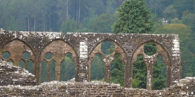
At the bottom of the embankment, far below the railway line, I found myself on a level footpath that ran along an embankment that led down to the river. It became clear to me that this path was once the foundation for an old railway that had been replaced by the one which I had just left. As I walked along, I realised that this old railway bed was what the two gentlemen had meant by walking along the railway track.  The path wound its way through the depths of the Vale following the course of the river. The scenery down in the valley did not disappoint. It could not have differed much from what it was like when Edward Lear walked along the Vale 129 years earlier.

After a while, I reached what must have once been a railway station. I had arrived at the old railway station of Aghios (Saint) Paraskevi. This was part of a group ecclesiastical buildings. A suspension bridge for pedestrians ran from near it across the river to the other shore. Away from the river, there were some picturesque pools. The whole area was luxuriant with many trees, some with branches hanging over the stream.

The religious compound was not present when Lear walked the Vale. The old railway was built in 1910 as was the present church of Aghios Paraskevi (that stands on the site of a 13th century church). The bridge that I crossed was constructed in the 1960s. Before that, pilgrims could only reach the church by boat (see: https://www.johnsanidopoulos.com/2012/07/st-paraskevi-in-valley-of-tempe.html).

About two kilometres further on, the Vale reached its northern end. I found Robert and Margaret sitting in their Land Rover in a car park, enjoying hot tea from a thermos flask. I cannot remember whether I told them about my lucky escape whilst walking along the railway in the rocky cutting, but if I did not, which is likely because I would not wanted them to have been worried, now it is far too late. My two dear friends are now no more than fond memories, and the Pineios still flows through the Vale of Tempe.

Illustration is one of Lear’s pictures of the Vale of Tempe in 1848