
There is a grey sky over Chelsea Old Town Hall this cold Sunday morning in October. The sun is trying to penetrate the clouds. Will it succeed? We hope so, but possibly we are being over optimistic.

There is a grey sky over Chelsea Old Town Hall this cold Sunday morning in October. The sun is trying to penetrate the clouds. Will it succeed? We hope so, but possibly we are being over optimistic.
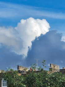
Clouds grey and white
Always very unpredictable
That’s British weather
THERE IS A HOUSE in Hampstead’s Downshire Hill, where John Heartfield (1891-1968) lived between 1938 and 1943. Born in Germany as Helmut Herzfeld, he was an artist who employed art, and in particular photomontage, as a political weapon. He was anti-Nazi and fled Germany in 1933, arriving in England in 1938, having spent some time in Czechoslovakia. Nearby, are houses where three other artistic creators lived: Roland Penrose and his wife Lee Miller; and the creator of The Muppets, Jim Henson.
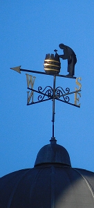
Heartfield’s home on Downshire Hill has a peculiar feature, which might have been added long after he lived there. It is a weathervane. That is not a particularly unusual embellishment, but on closer examination, it is not a run-of-the-mill British weathervane. Weathervanes in England often have the four points of the compass abbreviated as NSEW, that is, north, south, east, and west. The one on Heartfield’s former home has the letters NSOE. At first, I thought that the O was an abbreviation for the German for east, ‘Ost’. If the weathervane was German, it should have had the letters NSOW. Then, I thought that the O is probably an abbreviation for the Italian for west, ‘ovest’ or for ‘oeste’ the Portuguese and Spanish words for west. This makes sense because the other points of the compass in those languages are abbreviated as: N, S, and E. Short of ringing the doorbell to ask, the linguistic identity of the weathervane will have to remain a mystery to me for the present.
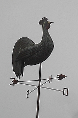
LOOK UP AND if your eyesight is reasonably up to scratch, you might well be lucky enough to see a weathervane on top of a church steeple or some other high point on a building. The ‘vane’ in weathervane is derived from an Old English word, ‘fana’, meaning flag (in German the word ‘Fahn’ means flag). Weathervanes are simple gadgets that indicate the direction of the wind. They usually consist of an arrow attached by a horizontal straight rod to a flat surface that catches the wind. The rod is mounted on a vertical support in such away that it can rotate as the wind catches the flat surface. The horizontal rod with the arrow rotates so that it offers the least resistance to the prevailing wind. Beneath the rotating arrow are often indicators that are labelled with letters denoting the four points of the compass. If, for example, the wind begins to blow from east to west, the horizontal rod will rotate so that the arrow is above the ‘E’ denoting east. Some weathervanes substitute the horizontal rod with a single flat asymmetric object that can catch the wind and rotate. Often the object seen above churches is a cock or other bird, whose beak will indicate the direction of the wind. I suppose that for birds wind direction is quite important.
The weathervane is not a recent invention. It was invented in the 2nd century BC both by the Greeks and the Chinese but separately. Some of the oldest Chinese weathervanes were shaped as birds and later, at least by the end of the 9th century AD, bird shaped vanes became used in Europe. Although avian weathervanes are still very common, a wide variety of other shapes have been used. Sundials, weathervanes, now archaic, only give an approximate indication of time and wind direction respectively. However, unlike sundials, which do not work when the sun is not shining, weathervanes work in all weather conditions and in day and night, although they are somewhat difficult to see at night-time. Despite their relative inaccuracy compared with modern instruments for measurements of wind, weathervanes are attractive adornments to buildings both old and new.

Whether the wind blows
North or south or east or west
I will show you which

Some folk say that
When cows lie down on the ground
Rain is in the offing

IN A COUNTRY SUCH AS ENGLAND, the profusion of sundials seems almost ironic given how often the sky is grey and the sun is hidden. Since the year 2000, the average monthly sunshine ranges from less than 50 hours to a little over 250 hours per month (https://www.statista.com/statistics/584898/monthly-hours-of-sunlight-in-uk/), the variation reflecting the different seasons of the year. The average number of daylight hours varies from 8 in January to 16.5 in July (http://projectbritain.com/weather/sunshine.htm). Using these figures and a bit of basic arithmetic, one can estimate that there is sunshine for about 20% of the daylight hours on an average January day, and about 89% of the daylight hours on an average July day. Roughly speaking, a sundial, which can only be of use when the sun is shining, is likely to be helpful for telling the time in England between 20% and 89% of daylight hours on an average day. Nevertheless, there is a great number of these partially usable timepieces in existence in gardens and on buildings in England. The figures I have calculated make the words of my opening sentence only slightly less drastic than they seem. Yet, relying on sundials as timepieces is, as my wife pointed out, a good interpretation of the words of Samuel Johnson (1709-1784), quoted by his biographer James Boswell (1740-1795):
“The triumph of hope over experience.”
This was not said in relation to sundials, but to:
“…Johnson’s hearing of a man who had remarried soon after the death of a wife to whom he had been unhappily married.” (https://www.phrases.org.uk/meanings/hope-over-experience.html)
In other words, enjoy the sight of sundials in their many shapes and sizes but do not become wedded to them if knowing the time is of importance to you.
FOUR MILES FROM ST GILES Pound and four and a half miles from ‘Holborn Bars’, there stands a white stone milepost close to a pond at one of the highest places in north London. This pond in Hampstead got its name Whitestone because of its proximity to this white milepost. Originally known as ‘Horse Pond’, it was a place where horses could drink and wash their hooves. The pond was supplied with ramps to allow easier access for the horses. These were preserved when the pond’s surrounding banks were extensively renovated in 2010.

The pond used to be supplied by dew and rainfall but was later kept filled by water from the mains water supply, which is fortunate given how little rain falls during some periods of the year. Being a shallow pool in an exposed location so high above sea level (443 feet), it is often covered with ice in cold weather.
A tall flagstaff stands a few feet west of the pond. This marks the spot where there was once a beacon that formed part of a network of beacons that could be lit to communicate with each other during the 16th century when the threat of invasion by the Spanish armed fleet was feared. The beacon by the Pond was the most northerly of a series of beacons which originated on the cliffs at St Margarets near Dover. This network can be seen on old maps such as that drawn by William Lambarde (1536-1601) in 1570, several years before the arrival of the famous Spanish Armada. Currently, the only purpose of the tall white pole is to fly the red and white flag of the City of London high above the pond.
High as the pond is, it is not the highest point in Hampstead. That honour goes to the small observatory on the top of the reservoir just south of the pond. This point is 449 feet above sea level. The reservoir is a:
“… wonderful example of mid Victorian architecture … The reservoir and railings were constructed in 1856 for the New River Company to serve Hampstead with the water being delivered by pipes from Highgate. The company was absorbed into the Metropolitan Water Board in 1902.” (http://www.ianclarkrestoration.com/122/Hampstead_Reservoir,_London_-_Thames_Water/).
This structure is inaccessible to the public, but the observatory perched on top of it is, in normal times, opened to the public occasionally.
The small observatory topped with a dome was established in 1910 by the Hampstead Scientific Society (www.hampsteadscience.ac.uk/astro/history.html). It can be seen best from Lower Terrace. The first secretaries of the Society were two keen astronomers, Patrick Hepburn and PE Vizard. The first telescope, a ten-and-a-half-inch reflecting telescope, was donated by Colonel Henry Heberden on condition that it be used by members of the public. In normal times, the observatory is still open to the public on clear nights. At the beginning of the 20th century, nights were much clearer than they became later and valuable observations could be made. As time passed, both dust and light pollution have rendered it far more difficult to make any observations at all. In addition to astronomical uses, the observatory is home to a collection of devices used in meteorology. The weather station at the observatory has the longest continuous record of climate measurements for any still extant meteorological site in Greater London, having begun in 1909 (www.weather-uk.com/page2.html).
Returning to the Pond, I remember that during my childhood, the traffic around it was terrible, especially during rush-hours. It became even worse when police officers arrived to try to control it. While I was studying at Highgate School, there was an extremely bright boy in my year group, ‘B-W’ was his surname. During physics classes, he appeared not to pay attention to the teacher because he was too busy designing complicated electronic circuits. When we took our physics mock-O’Level examination, he was the only person in the class to pass it, exceeding the pass mark by a large margin. My result in this test was a miserable 15%, which was five times higher than the boy with the lowest mark. In case you are wondering, I did well during the actual examination a few months later.
One morning, B-W arrived at school and showed us a complicated diagram. It was his proposal for a scheme that should allow traffic to flow smoothly around Whitestone Pond (where five major roads meet). It is a long time since I saw the scheme that he designed, but I would not be surprised if it is much the same as the much-improved traffic flow system that exists today and was only instituted a few years ago.
The Pond has been part of my life intermittently since my earliest days. In the late 1950s, and early 1960s, my parents and I used to walk past it every Saturday morning on our way to the shops in the centre of Hampstead. During the ‘80s, and ‘90s, I used to drive past it on my way to see my father and other members of my family, who lived in the Hampstead Garden Suburb, which is north of the Pond. More recently, my wife and I have been finding that visiting Hampstead, which has a rich history and many attractive old buildings, is a lovely way to pass time and enjoy fresh air. Whitestone Pond and the carpark nearby make for a good starting point for a stroll through a part of London that has to a large extent resisted the ravages of time and so-called ‘progress’.
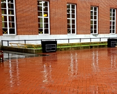
Falling rain drops
Relentlessly wetting the flat
Path beneath my feet
OUR FRIENDS INTRODUCED us to a square in north London, which we had never visited before despite the fact it is near the pub where we meet them regularly, when covid19 regulations permit. The square, Camden Square, is about 1000 yards northeast of Camden Town Underground Station. The rectangular open space that comprises the ‘square’ was developed between 1830 and 1850 and formed the centrepiece of Marquis of Camden’s New Town development (https://londongardenstrust.org/). The square and Camden Town take their names from John Pratt (1759-1840), the First Marquis of Camden (https://en.wikisource.org/wiki/Dictionary_of_National_Biography,_1885-1900/Pratt,_John_Jeffreys). In 1736, he was called to the Middle Temple, where many years later my wife became a barrister. In 1795, he was appointed Lord Lieutenant of Ireland, and was not popular with the Irish. He was opposed to emancipation of the Catholics and to parliamentary reform. His attitude towards the Irish was repressive and he developed an intrusive intelligence network. In May 1798, insurrection broke out in Ireland and he appealed for more military personnel to be sent from England. Later that year, he was replaced by Lord Cornwallis (1738-1805). A remarkable soldier, Cornwallis was involved in attacking the formidable Tipu Sultan (1750-1799) and forcing him into signing an unfavourable treaty in 1792 at Seringapatnam near Bangalore and Mysore in India.
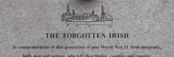
Given the Irish antipathy towards the Marquis of Camden when he was Lord Lieutenant of Ireland, it is ironic that at the southeast corner of the square, we find the building that houses the London Irish Centre (https://www.londonirishcentre.org/). It was founded in 1954 to provide assistance to Irish migrants arriving in London after WW2, often quite unprepared. Its present home, 50 Camden Square was bought in 1955. Its location was chosen because it is close to Euston Station, where many of the Irish arrived by train from Holyhead. A plaque placed on the outside of the Centre’s elegant neoclassical Victorian façade commemorates the ‘Forgotten Irish’. It reads:
“In commemoration of that generation of post-WW2 Irish emigrants, both men and women, who left their homes, counties, and country. They came to work and rebuild this city and country, ravaged and destroyed by war. Sometimes called ‘The Forgotten Irish’, many would never return to Ireland. This plaque recalls their contribution and their loss…”
The Centre contains many facilities including a good library, a bar, and a community café.
The Irish centre and almost all the houses on the eastern and southern sides of the square date back to long before WW2. However, some of the buildings on the western side of the square are post-WW2, most likely built on the sites of houses destroyed by bombing during the war.
Number 57 on the southern side of the square was home to the Indian politician Krishna Menon (1896-1974) between 1924 and 1947, when, after India won independence, he became Indian High Commissioner to the UK. Menon received much of his education in London, at the London School of Economics and University College. He was also admitted to the Middle Temple. Menon worked with the publisher Allen Lane at the time when Penguin Books was established and might have been the inspirer of the idea of producing cheap editions of quality titles, which was the principle adopted by Penguin.
As a member of the Labour Party, Menon was elected borough councillor of St Pancras, and was later given the Freedom of the Borough, an honour which had only one other recipient, George Bernard Shaw. A close friend of Jawaharlal Nehru, the Indian patriot and future Prime Minister of India, Menon was President of the India League between 1928 and 1947. The League fought for the complete independence of India from the British. Once Menon was asked whether India would prefer to be ruled by the British Empire or the Nazis. He is supposed to have replied that one:
“ …might as well ask a fish if it prefers to be fried in butter or margarine.”
At Camden Square, Menon:
“… had a room and the use of the bath. His furnished room had a bed, a table, a couple of chairs, a wardrobe and a sideboard. Come hell or high water, he had to have his morning bath, and hell often broke loose when the Luftwaffe set out to put the torch to London. Krishna Menon’s landlady is still puzzled about this. Did he, she wonders, insist on his morning bath because of his religion? He paid a pound per week for rent, including the price of his breakfast tea and toast. The rent was modest even for Camden Town.
Krishna Menon used his room only for sleeping. He never gave any parties nor did he entertain guests. In the evening he returned at irregular hours, and if it was not late, he asked Mrs. Rouse for tea. While Krishna Menon was meticulous about his clothing, he left his room in Bohemian disarray. It is with some amusement that Mrs. Rouse recalls that his discarded clothing was scattered all over the room and that he seemed to be unable to fold his towels ‘neat-like’.”
(quoted from “Krishna Menon” by Emil Lengyel).
Almost across the road from Menon’s home, is number 1 Camden Square, home to Robert Harbin (1909-1978) in 1928. ‘Who he?’, I hear you ask. Born Edward Richard Charles Williams in Balfour (near Johannesburg in South Africa), he came to London, aged 20, and began working in the magic department of Gamages toy shop. An accomplished magician, he performed in music halls and later in television and in films. He became interested in Japanese paper folding and became the first President of the British Origami Society, founded in 1967.
Other famous persons have lived in Camden square, many of them artists. They include the Dutch-born painter Lawrence Alma-Tadema (1836-1912), who lived briefly at number 4, when he first arrived in London from Belgium. The sculptor William Turnbull (1922-2012) lived in the square nearer the end of his life. During the 1960s, my mother worked alongside him in the sculpture studios of St Martins School of Art, then in Charing Cross Road next door to the famous Foyles bookshop.
Before I mention the currently most famous resident of the square, I should record the fact that there are no houses along the space’s northern edge. The northern edge is the southern boundary of the grounds of St Paul’s church, Camden Square. The church is a non-descript structure completely devoid of architectural merit. It was built as a temporary replacement of an older church that was designed by Frederick Ordish and John Johnson and built in 1849, and then severely damaged by bombing during WW2.
Number 30 at the north east corner of the square faces three trees whose trunks are surrounded by screens made of bamboo rods, some of which have padlocks attached to them. For, number 30 was the home of the popular singer Amy Winehouse (1983-2011). Some of the padlocks have her name inscribed on them by the mourning fans, who attached them to the trees.
Now that the covid19 pandemic is forcing us to meet others outdoors, the weather has become of even more interest than in healthier times. This brings us to George James Symons (1838-1900), who lived at number 62 Camden square between 1868 and 1900. At the age of 17, he became a member of the Royal Meteorological Society, becoming elected its President twice. He was a pioneer in the scientific study of rainfall and founded The British Rainfall Organization as well as establishing a Climatological Station in the square.
Fortunately for us, there was no rainfall whilst we walked around the square and through the peaceful, well-maintained garden in its centre. I am grateful to our friends for introducing us to this square full of diverse historical associations, some of which were new to all of us.
