A personal history about the south of India

THE COROMANDEL COAST stretches along the east side of India between the Krishna River in the north and the southern tip of the subcontinent. So, when I began reading “Coromandel” by Charles Allen (1940-2020), I was expecting to read a history of this coast and its hinterland.

The book’s subtitle is “A Personal History of South India”, and that is what it is. Although the Coromandel Coast is mentioned within the text, the book is primarily a very fascinating, well-researched and reasoned history of southern India, and how that history was influenced by events that happened north of the Narmada River, which the author took as an approximate dividing line between the northern and southern parts of the subcontinent.

I am very glad I read the book even though at first I was hoping that the author was going to concentrate on the east coast of India, rather than the whole of the south of the country. In fact, there is a great deal about the west coast of southern India, which. fascinating as it is, is not the Coromandel Coast. Despite my disappointment that Charles Allen strayed from the Coromandel Coast, about which I was hoping to read, this is an excellently written book.

Three informative, illustrated books about Albania and the Albanians

In the last few years, I have published 3 books about Albania and the Albanians:

ALBANIA ON MY MIND

This book describes Albania as I saw it when I made a trip there in 1984. Then, the country was being ruled by the isolationist, Stalinist dictator Enver Hoxha. The country was even more isolated from the rest of the world than is the case with North Korea today.

REDISCOVERING ALBANIA

This is a description of a visit I made to Albania in 2016. The book describes Albania as we found it then, and compares it with what I saw in 1984. It also contains descriptions of Albania made by other travellers at various times in the last 300 years.

FROM ALBANIA TO SICILY

This is one of the few books in English to describe the past and present of the Albanian-speaking people who migrated to Sicily in the 15th century to escape from the Ottoman armies that were invading the Balkans. It provides an in-depth study of the lives of this interesting group of people.

These three books are available as paperbacks and as Kindles from Amazon

Still standing but for how much longer?

COMMERCIAL STREET IN Bangalore (Bengaluru) is one of the main arteries of a busy shopping district – a bazaar area – in the centre of the city. It is close to an area occupied by military establishments, descendants of a former British military base, to which Sir Winston Churchill (no friend of India) was attached briefly when he was a young man. Another main road, Kamaraj Road, in the area used to be known as Cavalry Road. And another reminder of the area’s military proximity is Infantry Road that runs into the Commercial Street area.

There is a network of narrow lanes that run through the bazaar district. These are lined with shops of varying sizes, tradesmen, artisans, cafés, and other businesses. Numerous motorcyclists and autorickshaws thread their way through the crowds of pedestrians thronging the streets. I suspect that only a small number of these people notice or are interested in the architecture of the buildings lining these lanes. I am one of that small minority.

Many of the buildings in the bazaar are either modern or post 1947. There are still some earlier edifices still standing. Some are gradually falling to pieces and others are in good condition.

Recently, I was taking pictures of some of the older buildings and their traditional decorative features when a man came up to me and said:
“Very old. Historic buildings. Old, very old.”
How old they are, I do not know, but it is likely that they were already standing when India became independent in 1947. I did not ask the man, who commented on the buildings’ age, exactly when they were built. One of my reasons for not doing so was a consequence of an instance in Junagadh (a city in Gujarat) some years ago. We were looking at an interesting mausoleum in the centre of Junagadh, wondering about its age, when we asked a bystander when it was built. He answered:
“I don’t know. I wasn’t born then.”

The few intact attractive, old buildings in the Commercial Street bazaar area are lovely to behold. Given how many of them have already been replaced, I wonder how much longer those remaining will survive.

Remembering an old friend in London’s Marylebone

MY FRIEND MICHAEL Jacobs (1952-2014) studied history of art at A Level (university entrance examinations) and then later at university. Later, he became a prolific author. When we were in our late teens, we used to visit Hampstead’s second-hand bookshops together. A few days ago (early September 2022), I was walking along Marylebone’s New Cavendish Street when I spotted something that reminded me of one of our bookshop visits in the late 1960s.

There is a building on the northeast corner of New Cavendish Street and Wimpole Street, which caught my eye. As I passed it, I spotted a small plaque giving the architect’s details. It reads: “BANISTER FLETCHER & SONS ARCHITECTS AD 1912” Sir Banister Flight Fletcher (1866-1953) trained at London’s Kings College, University College, the Royal College of Art, the Architectural Association, and Paris’s École des Beaux-Arts. In 1889, he became a partner in the architectural firm founded by his father: Banister Fletcher & Sons. In addition to designing buildings, Banister Fletcher (and his father) wrote a book of great importance.

The book, “A History of Architecture on the Comparative Method”, which was first published in 1896, was republished several times during the 20th century. It was the standard reference work in English on the history of architecture.

Seeing the name Banister Fletcher on the building in Marylebone reminded me of an afternoon in Hampstead during the late 1960s. We were rummaging around the somewhat disorderly collection of books in Francis Norman’s bookshop in Perrins Lane when Michael discovered a copy of Banister Fletcher’s history of architecture, a book that was well-suited for the bookshelf of a student of the history of art. Michael bought it at an extremely reasonable price.

Until I spotted the building on New Cavendish, I had always associated the name Banister Fletcher with that afternoon with Michael in Hampstead. The building I saw is the first example of a structure that I have been able to associate with the author of the history purchased by my late friend.

Beyond London’s West End: the story of west London

BEFORE THE YEAR 1800, the West End was truly the western end of London. West of Mayfair and Marylebone, there was countryside: woods, fields, private parks, farms, stately homes, villages, and highwaymen. After the beginning of the 19th century, the countryside began to disappear as villages grew and coalesced and the city of London expanded relentlessly westward. What had been rural Middlesex gradually became the west London we know today.  My new book, illustrated with photographs and maps, explores the past, present, and future of many places, which became absorbed into what is now west London: that is London west of Park Lane and the section of Edgware Road south of Kilburn. Some of the places described will be familiar to many people (e.g., Paddington, Kensington, Fulham, and Chelsea). Other locations will be less known by most people (e.g., Acton, Walham Green, Crane Park, Harmondsworth, and Hayes). Many people have seen the places included in my book when they have looked out of the windows of aircraft descending towards the runways at Heathrow, and many of them will have passed some of these places as they travel from Heathrow to their homes or hotels. My book invites people to begin exploring west London – a part of the metropolis less often on tourists’ itineraries than other areas. “Beyond Marylebone and Mayfair: Exploring West London” is aimed at both the keen walker (or cyclist) and the armchair traveller.  

Beyond Marylebone and Mayfair: Exploring West London is available as a paperback from Amazon here:

https://www.amazon.co.uk/BEYOND-MARYLEBONE-MAYFAIR-EXPLORING-LONDON/dp/B0B7CR679W/:

Hampstead: a town on a hill

Hampstead High Street

A town on high

Home of famous artists and authors

Hampstead by name

ENJOY my new book which takes a fresh look at north London’s Hampstead: its sites, its personalities, its character, and history. “Beneath a Wide Sky: Hampstead and its Environs” is available from Amazon: https://www.amazon.co.uk/dp/B09R2WRK92

History surveyed from a hilltop

IT IS A SURPRISINGLY tiring climb to reach the summit of Primrose Hil, just north of London’s Regents Park. Yet, it is well worth making your way to the top, which is 210 feet above sea level and considerably high than much of the rest of London.

From its lofty peak, you get to see a wonderful panorama of central London and its environs. One thing struck me as I stood on the hill on New Years Day 2022. In one field of vision, without moving my eyes, I saw both St Pauls Cathedral and the Shard that stands next to London Bridge station. The former was consecrated in 1697 and the latter, the glass clad Shard was completed in 2013. Thus, in one view, I was able to see just over 300 years of history. And with all of the construction cranes that can be seen from aloft, it seems that history continues to be made, for better or for worse.

A village by the River Thames

FOR MORE THAN THIRTY YEARS between the mid-1970s and about 2003, I made occasional journeys between Stoke Poges in Buckinghamshire and Eton in Berkshire. On each of these, I passed signs indicating roads to Datchet, yet it was only in November 2020 that we decided to take a look at this village near the River Thames and opposite Windsor.

Writing in 1876 in his “Handbook to the Environs of London”, James Thorne commented that Datchet in Buckinghamshire:

“… is a quiet genteel place of abode, dull and uncharacteristic in appearance; as such places usually are; but the neighbourhood is beautiful and interesting.”

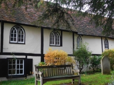
While today Datchet continues to appear genteel, it is not as dull as Thorne made out. Much that Thorne might have seen had he visited it when researching his book can be seen today. For example, the Church of St Mary, which was built in 1860 on the site of an older one, which was demolished in 1857, is attractive despite having been completely rebuilt in Victorian Gothic style.

The church stands beside The Royal Stag pub. Although the front part of the pub facing the village green was added in the 18th century, the rear part that faces the churchyard dates back to 1500 or before (https://datchethistory.org.uk/streetshouses/the-north-greens/the-royal-stag/). Over the centuries, the older parts of this building have undergone modifications, but externally it looks quite old. The pub was visited by the astronomer William Herschel (1738-1822) and his family and is mentioned in “Three Men in a Boat” by Jerome K Jerome.

The pub faces a green in the middle of which there is a memorial to those of Datchet, who fell in both World Wars. A plaque on the memorial relates that the men who fell in WW1 were fighting the combined forces of “Germany, Austria, Turkey, and Bulgaria”. As far as I can recall, this is the first WW1 memorial I have seen that mentions Bulgaria.

Facing both the pub and the church across the green, there is a long half-timbered building with four gables. Thorne describes it as having five gables, but we could only see four. Between two of the gables, there is an area of roof tiling on which a sculpture of a cat appears to be chasing a sculpture of a rat. This building now divided into dwellings is collectively known as ‘Manor House’. Although much modified, this building might have been constructed in the late 16th century. The mock Tudor facing, which we see today, was added in about 1870.

A building named ‘The Old Manor House’ next to the building just described was rebuilt in 1955 on the site of a building constructed first in the 17th century. A row of brick cottages stands on the other side of the gabled building. These attractive old structures are, like their neighbour, timber-framed. They might be older than their larger neighbour. Their brick frontage was added either in the 17th or 18th century.

Another old cottage faces the London Road, which runs along the side of the churchyard. This is ‘Church Cottage’, which was built in about 1500 and has undergone little change since then. It is probably the oldest building still standing in Datchet. James Cottages, neighbouring Church Cottage, are far younger, having been built in 1853 to commemorate James Pearce, who had died in 1851.

I could describe some of the other old buildings that make Datchet a lovely place to linger for a while, but I hope I have written enough to intrigue you. Before concluding, I will tell you a bit about the village’s name, which is strange to my way of thinking. The excellent village website (https://datchethistory.org.uk) provides much interesting information about Datchet and reveals the following about the name. Current thinking links Datchet (‘Decetia’ in Latin) to the French town of Decize, a point in central France where the River Loire could be crossed with ease in Gallic and Roman times. The website observes:

“… Decize and Datchet have more in common than an unusual name; both were originally established on islands of high ground in the low-lying land of a major river route; the remains of Decize’s ancient fort is shown on the map as ‘oppidum’. Settlement sites like this are common, but it may still be significant that these two share such a distinctive name which is not found anywhere else.”

Although we spent less than an hour in Datchet, that was sufficient time to discover that far from being “dull and uncharacteristic in appearance” as claimed by the 19th century writer James Thorne, it is quite attractive even if not in the same league as villages such as Lavenham in Suffolk and Stow-on-the Wold or Bourton in the Cotswolds.