King Richard the Third, Henry Irving, and James Bond

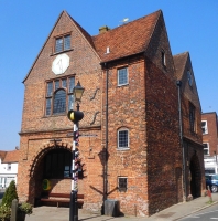
SHEEP WITH THEIR LAMBS were grazing or resting in the sunshine in a meadow beside the roadway leading to the entrance of Greys Court near Henley-on-Thames in Oxfordshire. Although the main house at Greys Court was closed (because of the covid19 pandemic) when we visited the estate in April 2021, there was plenty to enjoy in the gardens and fields that are contained in its extensive grounds. The highlight for me was the formal garden enclosed within ruined stone walls that extend from two sides of a tall tower topped with crenellations.

Grey Court House

Greys Court has an interesting history, most of which I have summarised from what is contained in a good guidebook published by the National Trust, to which Greys Court and its grounds were donated in 1969. I have also consulted “Elizabeth’s Rivals” by Nicola Tallis. The tower and the attached ancient wall are the only remains of what was constructed by the De Grey family, who had been living on the estate since (or before) the Domesday book was compiled in the late 11th century. One of the family, Walter de Grey (died 1255), Archbishop of York, was a supporter of King John when he was forced into signing the Magna Carta in 1215.

In December 1346, the then owner of the estate Sir John, 1st Baron Grey of Rotherfield (1300-1359) was granted a licence to ‘crenellate’ Greys. What this means is that he was authorised to surround his home with a fortified curtain wall. It is the remains of this mediaeval wall that surrounds the walled garden that attracted me. After Robert, 4th Earl of Grey died in 1387, the estate passed to his daughter Joan, who was married to Lord John Deyncourt. Then, it was inherited by their daughter Alice, who married Lord William Lovell (died 1455). Through this marriage, the estate became owned by the Lovell family.

When Alice died in 1474, she left Greys to her grandson Francis Lovell (1456-c1487), who managed to ‘back the wrong horse’ by being a supporter of the Duke of Gloucester, who became King Richard III. After fighting alongsid the king, who was defeated at the Battle of Bosworth (1485), the Crown confiscated Greys and awarded it to Jasper Tudor (1431-1495), uncle of King Richard’s successor, King Henry VII. In 1514, Greys was leased to a member of Henry VII’s court, Robert Knollys (died 1521). His rent was a single red rose to be paid each Midsummer.

Sir Robert’s son Sir Francis Knollys (1511-1596), a devout Protestant, spent most of the Roman Catholic Queen Mary Tudor’s reign (1553-1558) abroad, returning following the accession of Queen Elizabeth I, who was a cousin of his wife Catherine (1524-1569), whose mother was Mary Boleyn (sister of Henry VIII’s wife Anne Boleyn). One of Francis’s many important jobs was guarding the imprisoned Mary Queen of Scots.

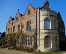
Sir Francis demolished much of the mediaeval Greys Court building and rebuilt it with three gables in the Elizabethan style. His renewed building is what we see today as Greys Court House. One of his reasons for this and other constructions was that he hoped that he would be able to host Queen Elizabeth there, but she never visited. The works were carried out between 1559 and 1596. Francis’s son Sir William Knollys (1544-1632) inherited the Greys estate. It is thought that Shakespeare’s character Malvolio in “Twelfth Night” was based on William. The Knollys family made several modifications and additions to the buildings on the estate but by the late 17th century they began to lose interest in maintaining it. Lettice Kennedy (died 1708), the last of the Knollys to live at Greys sold it to James (or William, according to one source: “Greys Court Volume 2 – Historic England Research Report”: research.historicengland.org.uk) Paul in 1688. Mr Paul and his wife Lady Catherine Fane had a daughter Catherine, who inherited Greys Court. The daughter, Catherine, married Sir William Stapleton (1698-1739) in 1724. Thus, the Stapleton family acquired the property.

Sir William was wealthy.  Some of his money came, as the National Trust discreetly puts it:

“…also from sugar plantations in Antigua and Nevis, acquired in the 17th century.”

His son, Sir Thomas Stapleton (1727-1781) inherited Greys. He was a member of the infamous Hell-fire Club along with its principal member and founder, his cousin Sir Francis Dashwood (1708-1781) of nearby West Wycombe. Sir Thomas did not live at Greys Court but arranged for the transformation of the mediaeval remains into ‘Gothick’ follies including the addition of the crenellations that can still be seen on the Great Tower. He also added the two-storey bow windows to Knolly’s Elizabethan house after his marriage to Mary Fane in 1765. She was responsible for many more modifications of the house and its outhouses.

The Grey estate remained in the Stapleton family for several generations, but it was only in 1874 that another male member of the family, Sir Francis Stapleton (1833-1899) began living in it. With no heirs, he left it to his nephew Miles Stapleton, who showed no interest in the place, eventually selling it to a widow, Mrs Evelyn Fleming, in 1934. Both her sons became extremely well-known. Ian Fleming was the creator of the fictional character James Bond. Ian’s brother Peter was an adventurer, soldier, and travel writer, whose life was far more exciting than that led by James Bond. Mrs Fleming was hoping that Greys would be a place where her son Peter could write between his travels, but his marriage to the actress Celia Johnson in 1935 put an end to this idea. So, she sold the property in 1937. The buyers were Sir Felix Brunner (1897-1982) and his wife Elizabeth (1904-2003).

Sir Felix was grandson of the politician and industrialist Sir John Brunner (1842-1919), who was one of the founders of the Brunner Mond & Co chemical company, which became part of ICI in 1926. Sir John was also a supporter of Octavia Hill (1838-1912), the founder of the National Trust, which was formed in 1895. Incidentally, Octavia was also involved with saving London’s Hampstead Heath from disappearing by being built on.  As well as serving in WW1, Sir Felix was a Liberal politician. He stood in various Parliamentary elections but was never elected to become an MP. In 1926, he married the actress Elizabeth Irving (1904-2003), a granddaughter of the famous actor Henry Irving (1838-1905).

In 1969, Sir Felix and Lady Elizabeth donated Greys Court to the National Trust and continued to live there. After she was widowed, Elizabeth continued to live at Greys Court, where she died in 2003. During their occupation of the Greys Court estate, the Brunners did much to improve and beautify it, rendering it one of the loveliest National Trust properties that I have visited so far.

I had never heard of Greys Court until a few weeks ago when we drove past a road sign pointing at a road leading to it. As we had never come across the name before and were curious about it, we returned a few weeks later and discovered what a gem of a place it is.  While it is relatively simple to describe its history, the opposite is the case when it comes to describing its appearance. Photographs help to do justice to its attractiveness but the best way to appreciate it is to visit it yourself.

Growing in the village stream

MANY PEOPLE ENJOY eating watercress. I quite like it, but it is not my favourite.  I prefer eating its close and more piquant relatives: mustard and wasabi. As its name suggests, watercress is an aquatic plant that lives in a watery environment. It could almost be considered an edible water weed. This April (2021) we visited Ewelme, a small village in Oxfordshire, where watercress is cultivated in the river that runs through it. We had come to Ewelme to see its alms-houses and school, which were built in about 1437 and are still being used for their original purposes. I will relate more about these in the future.

On our way to the village, we met some cyclists, who told us about the watercress cultivation in Ewelme and recommended that we took a look at the set-up. I was interested to see it as I had never (knowingly) seen watercress growing. Also, I was curious because I have often walked past Willow Cottages on Willow Road in Hampstead. It was in this row of dwellings that Hampstead’s watercress pickers lived many years ago. They gathered the crop from streams flowing on nearby Hampstead Heath.

The name Ewelme is derived from the Old English ‘Ae-whylme’ meaning ‘waters whelming’ or ‘source of a stream or river’. In the early 13th century, the place was known as ‘Eawelma’. The spring after which the village is named is just north of Ewelme. Water from the spring that flows through the village is in Ewelme Brook, which is a short tributary of the nearby River Thames. It meets the Thames 1.2 miles upstream from Wallingford Bridge. Watercress grows best in alkaline water such as flows in Ewelme Brook, which rises in the chalky Chiltern Hills.

The watercress beds can be found in Ewelme near the northern end of the High Street, northwest of the attractive village pond that forms a part of the Brook. They were established in the 19th century. Watercress from Ewelme was taken to Wallingford from where it was carried further afield by train. In 1881, the idea of a rail link between Ewelme and Wallingford was mooted, but the line was never built. It was in that year that:

“…Smiths of Lewknor and South Weston, who were established at Brownings by 1881, and created cress beds along the roadside stream probably in stages. The business continued until 1988, with cress initially transported from Watlington station for sale in the Midlands, Covent Garden, and Oxford.” (www.british-history.ac.uk/vch/oxon/vol18/pp192-234)

The Ewelme watercress beds were abandoned in 1988 but restored by the Chiltern Society after 1999. This organization continues to look after them (https://chilternsociety.org.uk/event/chiltern-society-ewelme-watercress-beds-conservation-volunteers-6/2019-02-02/).

The watercress beds at Ewelme are a series of rectangular enclosures in a widened part of the stream. The cress grows, floating on the water in the enclosures. Pairs of enclosures are arranged sequentially like shallow steps in a staircase. The shallow water flows rapidly from one enclosure to the next through small gaps in the stone barriers that demarcate them. Swarms of watercress leaves on their stems almost fill each of the enclosures, deriving nutrients and water from the continuously changing water flowing through their roots. I imagine that picking the crop involves wading in the watery watercress beds.

Although Oxfordshire is no longer one of the major counties for watercress cultivation, what can be seen at Ewelme is pleasing to the eye. The counties where most of this plant is now grown include Hampshire, Dorset, Wiltshire, and Hertfordshire (https://en.wikipedia.org/wiki/Watercress). Alresford in Hampshire, near Winchester, is known as the UK’s watercress capital.

Although I am not keen on raw watercress, I prefer it served in a soup. My late aunt used to make a superb watercress soup using fresh watercress added at the last minute to a homemade vegetable stock. We have tried making it with meat stock, but this was not nearly as nice because the fresh taste of the almost uncooked watercress gets masked by the flavour of the stock.  With this small bit of culinary advice, I will leave the watercress beds of Ewelme and wish you “bon appetit”.

A historic town hall

FIRST WORLD WAR veteran William Frederick Stone died aged 108 in January 2009. He moved to Watlington in Oxfordshire in 1986 and lived the rest of his life in this small town. A popular figure in the town, he would have often passed the place’s Town Hall, which had been in existence even longer than him.

The name Watlington is probably derived from ‘tun’, meaning ‘fence’ or ‘enclosure’, and the people of ‘Wacol’ or ‘Waecol’, who also gave their name to the famous old road known as Watling Street. The town is close to another ancient cross-country route, the Icknield Way (https://en.wikipedia.org/wiki/Icknield_Way). There is evidence that there was a settlement at Watlington in the 6th century AD. The current street layout was already established by the 14th century and that there were inns in the town by the following century. During the English Civil War (1642-1651), Parliamentary troops were billeted in the town on the night before the Battle of Chalgrove Field on the 18th of June 1643, a battle in which their opponents, the Royalists, were victorious (www.britishbattles.com/english-civil-war/battle-of-chalgrove/).

Twenty-one years after the battle, in 1664, Watlington’s town hall was built by Sir Thomas Stonor (c1626-1683). He lived at Stonor Park, which is 4.7 miles south east of Watlington. The Stonor family were Roman Catholics and retained their faith throughout the Reformation and suffered for that during the 16th and 17th centuries.

The brick town hall is unusual in that no two of its sides are equal in length and none of its corners are right angles (www.watlingtontownhall.com/history.html). Part of the ground floor is an arcade open to the outside air. This area was formerly used to hold markets. The first floor of the building served as a grammar school in the 19th century. The clock mechanism on the second floor is said to have come from the studios of the architect of St Paul’s Cathedral, Christopher Wren. This is not the only timepiece on the outside of the building. The other is a sundial, which has been gilded with 24 carat gold. The town hall was extended in the later 17th  or early 18th century (https://britishlistedbuildings.co.uk/101369012-town-hall-watlington#.YH28eehKhPY)  and was restored faithfully in the 20th century. Currently, the first-floor room, the former school, and beneath it, the under croft, are available for hire for social and other functions.

We came across the town hall quite by chance when driving home from visiting the Maharajah’s Well at Stoke Row. Today, we revisited the town on our way back from seeing several other places in Oxfordshire, about which I hope to tell you in the near future. Driving through England on roads other than motorways takes one through small towns and villages and many of these have features worth stopping to examine. Apart from the town hall, Watlington is a charming old place with several half-timbered buildings, cafés, and shops. Once again, a day trip to the countryside near London has proved rewarding.

A beautiful bank

LOVERS OF ARCHITECTURE will find much to enjoy amongst the buildings that fill the historic centre of the university city of Cambridge. Amongst the sea of old colleges, which are rich in fine architectural features, there are some attractive buildings whose existence are not solely due to the requirements of academia. One of these stands at the southern end of Sidney Street. Formerly Foster’s Bank, this picturesque edifice faced with alternating stripes of red and white and topped with a highly decorative clock tower, now houses a branch of Lloyd’s Bank.

Ebenezer Foster (1776-1851) and his brother Richard, both born in Cambridge, founded their bank in 1804. The bank was originally founded for the workers at the three mills that the Fosters owned (www.findagrave.com/memorial/181142444/ebenezer-foster). Because the university would not allow the Fosters to build railway lines to their mills, they constructed another mill close to the existing railway lines. This mill is now called Spillers Mill. The Foster family lived at Anstey Hall in Trumpington (near Cambridge) from 1838 to 1941. Ebenezer died in Trumpington. Ebenezer was Mayor of Cambridge in 1836, and later a county magistrate, then the High Sheriff in 1849. In addition to other public positions, he was a governor of Addenbrooke’s Hospital. Ebenezer’s obituary in “Cambridge Independent Pres” on Saturday the 31st of May 1851 noted:

“Mr. Foster was at the head of the first banking and mercantile establishments in the town. It is unnecessary, therefore, to say that his life was one of great activity and usefulness; and it is not too much to say that in every occupation, whether public or private, his conduct commanded universal respect.”

Before 1891, Fosters Bank was housed on Trinity Street in what was once the Turk’s Head:

“The rather attractive Tudor shop on Trinity Street now occupied by a clothes shop was once the Turk’s Head Coffee House, one of the earliest coffee houses in the country (17th century). It was much frequented by students. The upper floors later became the Turk’s Head Carvery, but it is now entirely given over to floral prints. The building was once the home of Fosters’ Bank, which later moved …” (www.cl.cam.ac.uk/~ckh11/cam.html).

Years ago, in the late 1960s, four of us, three friends and myself, ate a meal at the Turks Head. The bill for the four of us came to 14/6 (72.5pence) and we gave the waiter 15/- (15 shillings: 75 pence). My friends were horrified when I told the waiter:

“Keep the change.”

For, even in those far-off days, sixpence (2.5 pence) was a rather mean tip for a bill of 14/6.

In 1891, the bank building at the south end of Sidney Street, once Foster’s now Lloyd’s, was completed. It was designed by the architects A and P Waterhouse. Alfred Waterhouse (1830-1905) was the eldest of eight children. One of his siblings, Edwin Waterhouse (1841–1917), was one of the founders of the accountancy company Price Waterhouse (now incorporated into PWC). Alfred’s son Paul (1861-1924) joined his father’s architectural practice in 1884, becoming a partner in 1891, the year that the Foster’s Bank building was put up in Sidney Street.

Alfred Waterhouse and his practice were responsible for the design of many impressive buildings in the Victorian era. One of them, which is very well-known, is London’s Natural History Museum. Slightly less famous but equally impressive is the Prudential Assurance Building in London’s Holborn. This building is opposite numbers 337 and 338 High Holborn, which survived the Great Fire of London of 1666, and were restored by Waterhouse.   Apart from the bank in Cambridge and the Cambridge Union building, he also designed buildings associated with the following colleges: Jesus, Gonville and Caius, Pembroke, Girton, and Trinity Hall.  The bank in Cambridge is one of seven designed by Alfred Waterhouse.

I have entered the former Foster’s Bank only once. The glass-ceilinged banking hall is a riot of colour, its surfaces covered by tiles with sculpted surfaces. The octagonal clock tower is topped with a sharply pointed octagonal roof, one of the city’s many spires. The clock faces with their Roman numerals are made with tiling in several colours. Although now a branch of Lloyds, the name Foster can still be seen clearly above the main doorway.

When you next visit Cambridge, by all means admire Kings College Chapel and other architectural gems within the various colleges, but do spare some time to enjoy the former Foster’s Bank building on Sidney Street before visiting the nearby marketplace, which I always enjoy.

Dame Jane lies stone cold in the church

HER HEAD RESTS ON her stone-cold right hand with her elbow on a carved alabaster cushion. Her left hand is held lightly and limply against her left breast. She is a carved alabaster effigy of Dame Jane Cotton (1630-1692), widow of Sir John Cotton of Landwade (1615-1689). This sculpture of Jane Cotton lies against the north wall of the chancel of the Church of St Mary Magdalene in the village of Madingley, close to Cambridge. The church is open until 4pm most days and we got there by 3.45 pm a few days ago in April 2021. So, we were able to have a good look at the interior of this building whose construction commenced in the late 13th century (https://historicengland.org.uk/listing/the-list/list-entry/1127740).

Jane Cotton, who reclines close to the high altar, was the daughter and sole heir of Edward Hinde (c1598-1631) of the Parish of Madingley. Edward lived at Madingley Hall (www.thepeerage.com/p34969.htm#i349687), which is a few yards uphill from the church. Sir John Cotton did well by marrying Jane because by doing so, he acquired the manor of Madingley.

Sir John Hinde (or ‘Hynde’; c1480-1550; see: http://www.geni.com/people/Sir-John-Hynde-MP/6000000090158312935), Serjeant-at-Law and Member of Parliament, had been buying land at Madingley since the 1520s (www.british-history.ac.uk/vch/cambs/vol9/pp166-171). In 1544, the manor of Madingley, which had been held by several trustees for about 100 years, was bestowed on him by law. He commissioned the building of the lovely Madingley Hall, which was constructed between 1543 and 1547. Edward Hinde, Jane Cotton’s father, was a grandson of Sir John Hinde.

Sir John left Madingley to his son Francis, who left it to his son William, who married a widow, Elizabeth. When William died childless in 1606, his widow Elizabeth took over all of the Hinde estates. She remarried and leased Madingley Hall to Edward, who was son of William Hinde’s brother Edward (died 1633).

Jane’s father Edward (died 1633) settled his lands on his eldest son Anthony, who died before him, fighting in Denmark, in 1612, when Denmark was fighting Sweden for control of part of Norway. Anne, Anthony’s widow, ‘sold’ her interests in the lands to her father-in-law Edward (died 1633). Anne and Anthony had a son Edward, to whom Anthony’s father (Edward, died 1633) had left all his lands, but the grandson, Edward, died in an accident in 1631. Jane Hinde then became the heir to her father’s lands. Had Anthony and his son not pre-deceased Jane’s father, she would not have come into possession of the Hinde’s estates, and neither would have they come into the hands of Sir John Cotton. The lands at Madingley remained in the Cotton family until the beginning of the 20th century.

Sir John, husband of Jane, was buried with his ancestors at Landwade in eastern Cambridgeshire. His daughter Jane is interred in the church at Madingley. Her monument stands near the northwest corner of the nave. She is depicted kneeling with a small book in her left hand. Jane was a spinster. She died in 1707. Not far from her monument stands a lovely carved stone font. Covered with geometric decoration, this was made in the 12th century and probably stood in an earlier version of the church. Nearby, the internal walls of the bell tower are decorated with damaged sculptures made of wood. They are:

“… probably the survivors of the cherubim, perhaps on the nave roof, whose removal William Dowsing ordered in 1644.” (www.british-history.ac.uk/vch/cambs/vol9/pp173-176)

Although there is much to enjoy in the church at Madingley, it was Lady Jane Cotton’s reclining effigy that most sparked my curiosity. Looking into what is known of Jane’s heritage has revealed a little bit about the complexities faced by the ‘landed gentry’ when they considered who was to inherit their land.

The families mentioned are what some might describe, often expressing a sense of deference, as ‘old families’. What this means is that the family has sufficient documentary information to trace it back, maybe over many centuries, for many generations.  Well, if you think about it ‘old families’ are no different from other families because all of them must go back an awfully long way in history, even if the documentary evidence no longer exists.

How I avoided an awful fate

Chapel of Kings College, Cambridge

CAMBRIDGE IS A CITY which I have visited often since I was a child. My first recollection of the place was visiting Gonville and Caius College to meet my father’s long-term collaborator, the Hungarian born economist Peter Bauer (1915-2002). Later, after 1965, during my childhood and adolescence, we used to visit Cambridge to spend time with my father’s friend from his student days in Cape Town (South Africa), the social scientist Cyril Sofer (died 1974) and his wife Elaine. At first, I used to visit them with my family and when I was in my teens, I used to stay with them in their large Victorian house near Selwyn College. It was Elaine, who first introduced me to the joys of the drink known as ‘Bloody Mary’.Further travels to Cambridge followed when a childhood friend of mine attended Clare College to study for his bachelor’s degree. Through him, I met his good friend, now a well-known writer, Matthew Parris.

Many more visits to Cambridge followed my graduation at University College London in 1973. Although I remained in London to study for a higher degree, some of those who had graduated with me moved to Cambridge to pursue further studies. Three out of the nine of us, who graduated in physiology in 1973, embarked on doctoral theses in the city’s university. One of these was Lopa, who is now my wife. While she was at Cambridge, we were still ‘just good friends’, as the saying goes.

On one of my visits to see Lopa, I stayed in a house in Owlstone Road, which is south of the historic centre of Cambridge. A mattress was set up for me in a ground floor room with a street facing window. The room had been recently occupied by a female student, who had moved elsewhere. This sojourn in the city was during the time when the so-called Cambridge Rapist was assaulting young women, always within their homes, at an alarming rate. He carried out his attacks between October 1974 and April the following year.

Apparently, he followed potential victims to their homes and noted down their addresses in a notebook.The rapist carried out his first rape on the 18th of October 1974. Then another on the first of November, and yet again on the 13th of that month (https://en.wikipedia.org/wiki/Peter_Samuel_Cook). The latter was carried out within Homerton College, now a part of Cambridge University. He struck again on the 13th of February 1975, and then, unsuccessfully, on the 5th of May.

I slept soundly at Owlstone Road when I was staying there for a night or two. One morning, I woke up and saw police vehicles out in the road. It was the 8th of December 1974 and the rapist had raped a woman in the house next door to where I was staying, having broken into its ground floor room, which mirrored that in which I was sleeping. What none of us knew until after the perpetrator, Peter Samuel Cook, was eventually caught during his attack on Owlstone Croft’s nurses’ hostel in June 1975, was that the villain had listed the house in which Lopa was living with some other young ladies in his notebook of potential targets. The young lady who had occupied the room where I spent a couple of nights was in the rapist’s list of future victims.

Cook, who had knifed at least one of his victims, was a violent person and might have been awfully annoyed with me had he broken into the room where I was sleeping and found me, a man, instead of one of his intended female targets. Subsequent visits to the wonderful city of Cambridge have not, I am pleased to relate, been so potentially hazardous. Cook was jailed for life and died in Winchester Prison in 2004.

A glimpse of Mersea

SOMETIMES SUBMERGED DURING high tide, a causeway connects mainland Essex with the island of Mersea in the Colne and Blackwater estuaries. Markers with measurements are posted along the causeway so that people wishing to cross it when water covers it can tell how deep the water is. Road signs on both sides of the causeway advise drivers to test their brakes, especially if the road to and from the island is wet.

I first heard of Mersea Island in the mid-1970s when a friend of mine, with whom I have lost contact, married someone who farmed sheep on Mersea Island. However, it was only in 2021 that I first set foot on the island. The largest settlement on Mersea is the small town of West Mersea. We visited on the 12th of April, which was the first day (since the latest ‘lockdown began in December last year) that people were allowed to have drinks at pubs and eat meals at restaurants, but only in the open air. Fortunately, the sun was out and the waterfront mostly south facing.

In 895 AD, the island was known as ‘Meresig’; by 995 as ‘Myresig’; and in the Domesday Book as ‘Meresai’. The Old English word ‘mere’ usually refers to a lake (e.g., Windermere) but in the case of Mersea (and Margate) it refers to the sea. Thus, Mersea comes from words meaning ‘the island in the sea’. During the Celtic era (before the Roman conquest), the island was populated mainly with folk who fished and farmed. After the Romans established their capital at nearby Colchester, they built a causeway to Mersea Island and improved an already existing Celtic track (see: “The Shell Book of the Islands of Britain”, by D Booth and D Perrott). The Romans called the island ‘Maris Insula’ and archaeological remains of their presence there have been discovered and are now in Colchester Museum. There is a museum in West Mersea (www.merseamuseum.org.uk/) but this was closed on account of covid19 regulations. It plans to re-open in June.

The Normans also visited the island. The Domesday book recorded that in about 1086 there about 100 persons living on the island along with 300 sheep. The construction of the Church of St Peter and St Paul, which occupies the highest spot in West Mersea, began in 1046. Some of the original structure forms part of the fabric of the present church, which, sadly, was closed when we visited.

West Mersea is a holiday resort. Many fine homes, mostly modern, line the road that runs parallel to the waterfront, but which is separated from it by mudflats and salt marshes. Twenty or so large houseboats are moored at the water’s edge. Each of them has its own, often rickety-looking, boardwalk leading to it from the road. There are several pubs and eateries from which views of the boats moored by the town may be viewed. The town is famous for its oysters. We watched workmen hosing down crates filled with oysters, which look like large knobbly stones. Apparently, the Mersea oysters are highly prized internationally. Interspersed between boatyards for pleasure craft, there are yards where fishing vessels are maintained. At low tide, which is when we visited, the muddy shore is dotted with small boats of all types, some of them gently rotting away.

As it was late afternoon and we had to drive back to London and we had recently been well-fed, we spent no more than an hour in West Mersea. We hope to return when the weather warms up and then we will sample some of the local refreshment outlets. Although Mersea Island is only about 60 miles (and a lot of heavy traffic) from London’s Hyde Park Corner, it feels as if it is much further away: far away from anywhere.

Trouble in the village

TOLLESBURY IS A TINY village on the estuary of the River Blackwater in the English county of Essex, famed for its oysters, nature reserve, and sailing facilities. It is not far from Colchester and the smaller Tiptree famed for its jam manufacture.  Tiny though it is, Tollesbury appears in the Domesday Book, with the name ‘Tolesberia’ and in 1218 as ‘Tolesbir’. It is possible that the ‘Toll’ part of the name refers to a person who lived many centuries ago. The Church of St Mary the Virgin that stands at one end of the central village square was built in about 1090, possibly incorporating material from an earlier Saxon Church.

At the southern edge of the square, close to the northern boundary of the churchyard there stands a small wooden hut with a pyramidical tiled roof and one door with a small, barred window. It looks a bit like a garden shed but it was not built for storing tools and so on. For, this was the village lockup or ‘cage’. Built in 1700, it seems in remarkably good condition. The lockup, as its name suggests, was where local miscreants were locked up. It was a tiny prison. The reason that it is in a good state despite its age is that it has:

“…C20 waney weatherboarding, roofed with handmade red clay plain tiles and C20 hip tiles.” (www.prisonhistory.org/lockup/tollesbury-lock-up/)

Essex is home to plenty of village lockups. Apart the lockup from at Tollesbury, you can see village lockups at, for example, Great Bardfield, Thaxted, Canewdon, Great Dunmow, Orsett, Braintree, Roydon, and Steeple Bumpstead (hwww.essex.police.uk/SysSiteAssets/media/downloads/essex/about-us/museum/research/history-notebooks/66.pdf).  

These miniature jails were:

“… used in the eighteenth and nineteenth centuries to house criminals who were apprehended on suspicion of committing petty crime … Lock-ups were only temporary forms of imprisonment, usually for one or two people, before the local authorities of the day decided how to deal with the offender. Criminals could be released or sent to the closest large town for trial.” (www.essexlive.news/news/essex-news/historic-jails-essex-you-can-3227277)

Our friend, who lives in Tollesbury, suggested that probably the lockup was often used to house people who had drunk too much and needed to sober up. This not an unreasonable idea considering that at one time the village had six pubs.

Although there is much more that could be written about Tollesbury, I hope to do this after a future visit to this charming little place.

Gifts from India to an English village

LIFE DEPENDS ON WATER. A few days ago, at the end of March 2021, we drove to a village in Oxfordshire to see two old wells. They are no ordinary wells: they were gifts from India while it was still part of the British Empire.

Maharajah’s Well at Stoke Row

Edward Anderton Reade (1807-1886) was a British civil servant in India between 1826 and 1860. Brother of the novelist Charles Read (author of “The Cloister and the Hearth”), Edward was born in Ipsden, a village in Oxfordshire (www.oxforddnb.com/). He entered the East India Company in 1823. In 1832, he was transferred to Kanpur (Cawnpore), where he introduced opium cultivation to the district. In 1846, he became Commissioner to the Benares Division, a position he held until 1853 when he was moved to Agra.

Edward encouraged genial relations with the local Indian gentry and aristocracy. One of his Indian acquaintances, who became his good friend, was Ishri Prasad Narayan Singh (1822-1889), the Maharajah of Benares, who reigned from 1835 to 1889. During the years before the Indian Rebellion of 1857 (aka ‘First War of Independence’ or ‘The Indian Mutiny’), Reade and the Maharajah discussed much about England including the shortage of water that existed in Ipsden, the part of Oxfordshire where his family lived. Apparently, the villagers in this part of the Chiltern Hills had little or no access to clean drinking water, much as must have been the case for many villagers in India.

During the Rebellion of 1857, the Maharajah remained loyal to the British. In June 1857, the town of Kanpur was besieged by Nana Sahib and his forces. After 3 weeks, the British garrison surrendered under condition that the British inhabitants would be given safe passage out of the town. However, Nana Sahib decided to hold about 120 women and children and kept them housed in a house known as the ‘Bibighar’. This ended badly when some of the hostages were killed. Some of them tried to escape their grizzly end by jumping into a well at the Bibighar. This well became one of the most powerful images of the Rebellion in the minds of those who lived in Britain.

I do not know whether or not it was the tragedy at Bibighar that brought the conversations he had with Reade to the forefront of the mind of the Maharajah of Benares after the Rebellion was over, but in 1862, after his loyalty to the British had been formally recognised, he consulted Reade as to making a charitable gift to the poor people of Ipsden, whose plight he recalled. The Maharajah financed the construction of a well at Stoke Row, not far from Ipsden. It is also possible that the Maharajah remembered the help that Reade had given him when constructing a well in Azamgarh (now in Uttar Pradesh) back in 1831.

Work commenced on the well in March 1863. The well shaft was dug by hand, a perilous job for the labourers as they removed earth from the depths of an unlit and unventilated shaft, bucket by bucket. The shaft, 4 feet in diameter, was 368 feet in depth, greater than the height of St Pauls Cathedral in London, for this is depth of the water table at Stoke Row. Special winding machinery constructed by Wilder, an engineering firm in Wallingford, was installed. It is topped with a model elephant. The mechanism and the well stand beneath an octagonal canopy topped with a magnificent metal dome with circular glazed windows to allow better illumination. It resembles a ‘chhatri’ or architectural umbrella such as can be seen at war memorials on London’s Constitution Hill and on the South Downs near Hove.  The structure, restored in recent times, looks almost new today. Reade, who helped plan the Maharajah’s well, planted a cherry orchard nearby; dug a fish-shaped pond (the fish was part of the Maharajah’s coat-of-arms); and constructed an octagonal well-keeper’s bungalow next to the well. The profits from the cherries harvested from the orchard were supposed to help to finance the well, for whose water the villagers were not charged anything.  The Maharajah’s well at Stoke Row was the first of many such gifts given by wealthy Indians to Britain. Other examples include the Readymoney drinking fountain in Regents Park and a now demolished drinking fountain in Hyde Park, close to Marble Arch. According to the Dictionary of National Biography:

“Reade was wryly amused that an Indian prince should thus give a lesson in charity to the English gentry.”

The well at Stoke Row provided the locals with fresh water until the beginning of WW2, when, eventually, piped water reached the area. It provided 600 to 700 gallons of water every day. The Maharajah’s Well at Stoke Row is relatively well-known compared to another Indian-financed well next to the parish church at Ipsden, where Reade’s grave is located. The well, whose winding mechanism is similar to that installed at Stoke Row, is not covered by a canopy. It stands by a cottage next to the entrance to the churchyard. It was presented to Ipsden in 1865 by ‘Rajah Sir Deon Narayun Singh of Seidpor Bittree’ (I am not sure where this is: these are the words on the well), who had, like the Maharajah of Benares, remained loyal to the British during the 1857 Rebellion.

The Ipsden well is deep but not nearly as deep as that at Stoke Row. A lady, who lives in the cottage beside the well, told us that she had tasted water from the well and it was ice cold, deliciously clean, and tasted pure, having been filtered by many feet of chalk through which it has seeped. She said that once a year, the local water board opens the well and takes a sample of its water to check its purity.

Both wells are worth visiting. We parked in Benares Road in Stoke Row close to the Maharajah’s gift. After viewing the well head and its surroundings, we bought hot drinks at the village’s shop-cum-café, which his run by a couple of friendly people from Zimbabwe. I am grateful to Dr Peter U for bringing the existence of this unusual well to my attention.