SITUATED CLOSE TO the River Thames footpath between Hammersmith Bridge and Chiswick’s St Nicholas Church, in whose cemetery the artist William Hogarth is buries, is the popular Elder Press Café.
A ‘breakfast bun’ at the Elder Press Cafe
From the outside, it seems that this is a small establishment, but this is misleading. Behind the narrow shopfront facing the the Black Lion pub, the café extends a long way. It surrounds an inner courtyard with tables and chairs.
In addition to drinks and delicious patisserie items, the place offers a range of savoury dishes, which I saw being served to those on tables neighbouring ours. The food looked healthy as well as delicious. Service was attentive and friendly and prices were not exorbitant.
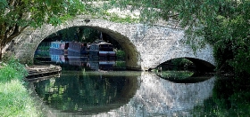
THE GRAND UNION canal, constructed from the late 1790s onwards, is an important artery of England’s canal network. Beginning at Brentford on the River Thames, it winds its way to Braunston and Birmingham. Along its way it meets other canals, some of which are designated ‘arms’. For example, the Paddington Arm joins the main canal at Bulls Bridge in west London and from there it makes its way eastwards to Paddington. Recently, we visited friends, who live in Northamptonshire, and they took us on a walk along another arm of the Grand Union, the Northampton Arm. This branch of the main canal begins near Gayton and Blisworth and runs to nearby Northampton, where it enters the River Nene, which flows eastwards towards The Wash, an enormous inlet of the North Sea.
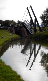
A swing bridge with a lock behind it
Much of the Northampton Arm is very narrow, just wide enough for passage of a single narrow boat. At regular intervals, the arm widens to allow vessels travelling in opposite directions to pass each other. Though short in length, only 4.6 miles, the Northampton Arm has seventeen separate, hand-operated locks for vessels to negotiate. The twelve of these, a flight of locks, is 1123 yards from the Gayton junction with the main canal. These twelve locks are along a stretch of canal only nine tenths of a mile long. The northernmost lock, that nearest towards Northampton, is a few yards north of a bridge carrying the M1 motorway. The locks carry the water from a bit over 300 feet above sea level nearest Gayton down to less than about 225 feet, each lock capable of lifting or lowering a vessel over 6 feet on average. Nearer Gayton, there is an old swing bridge, rather like a castle’s drawbridge. Looking at old maps, it appears that there were several more of these along the arm, but we only spotted one in the stretch between Gayton and the M1.
The canal and its associated towpath pass beneath the motorway through a giant concrete arch, paraboloid in shape and reinforced with horizontal concrete beams. Lined with graffiti, both conventional and anarchic artwork, walking under the motorway is an eery, rather science fictional experience. In contrast to this brutalist concrete arch, several lovely brick, hump-backed bridges carry minor roads over the Arm
“Almost immediately the Arm began to carry a large volume of merchandise and stayed busy for over 100 years through to after the First World War. In the post war years coal, grain and timber were supplemented by goods needed for the show industry such as strawboards for packing as well as iron ingots for castings. After World War II the carriage of goods ceased as road competition strengthened.”
Now, the Arm is used by intrepid canal boat owners, who are not averse to too much manipulation of lock gates. On the sunny Saturday afternoon that we visited the lock flight, we only saw one narrow boat attempting to negotiate the flight of twelve locks. In contrast, at Gayton Junction, the main Grand Union Canal, from which the Arm branches off, was full of pleasure-seekers’ narrow boats and other craft.
Though hardly used for freight these days, the canal system provides much pleasure to visitors both afloat and on shore. Wandering along the towpaths, one cannot fail to be amazed when considering the engineering ingenuity of the canal builders that we can still see today, as well as the work that is done to keep these waterways usable so many years after they were constructed.
THE VILLAGE OF APSLEY, now a suburb of Hemel Hempstead in Hertfordshire, has no connection with Apsley House at London’s Hyde Park Corner. The house, once home to The Duke of Wellington, derives its name from Apsley in Sussex. The place in Hertfordshire, which we visited with friends today, derives its name from an Anglo-Saxon word meaning ‘aspen’ (a kind of tree). We had lunch with our friends at a waterside pub called The Paper Mill.
Although the pub appears to be of recent construction, its name recalls the fact that it is built near the site of a once innovative paper making establishment. John Dickinson (1782-1869) was the inventor of a machine that made paper continuously as opposed to the previous manual methods that produced sheets of paper rather than rolls of it. He also invented a range of other practical products including security paper impregnated with silk threads, which was known as ‘penny post’, and, still in use today, the envelope with a gummed flap.
During the early part of the 19th century, Dickinson bought several mills in and around Apsley. He converted these for the manufacture of paper products. Only one of his three mills still stands today. The mills were located close to the then recently built Grand Junction Canal (now ‘Grand Union’). The canal provided a practical mode of transport for raw materials and finished products. The pub where we ate lunch is named to honour the memory of what was once a thriving industry in Apsley. It is located next to the canal and contains a framed family tree of John Dickinson’s family.
After a lazy lunch in the sun by the waterside, we took a leisurely stroll along the canal. Modern housing developments line parts of the stretch of water flowing through Apsley. Other parts are lined with shady trees and dense bushes, which hide modern office buildings that are served by a main road running parallel to the canal. Unlike other stretches of the canal, which we have walked along, there was a notable absence of waterfowl, except for a couple of swans with their four cygnets, and a pair of ducks. Other signs of life on the canal were the occasional slow moving narrow boat and the inhabitants of stationary craft moored along the banks and in a marina near the pub.
It was a hot afternoon and being beside the canal was pleasant. Occasional gentle gusts of cool air added to our enjoyment.
SOMETIMES SUBMERGED DURING high tide, a causeway connects mainland Essex with the island of Mersea in the Colne and Blackwater estuaries. Markers with measurements are posted along the causeway so that people wishing to cross it when water covers it can tell how deep the water is. Road signs on both sides of the causeway advise drivers to test their brakes, especially if the road to and from the island is wet.
I first heard of Mersea Island in the mid-1970s when a friend of mine, with whom I have lost contact, married someone who farmed sheep on Mersea Island. However, it was only in 2021 that I first set foot on the island. The largest settlement on Mersea is the small town of West Mersea. We visited on the 12th of April, which was the first day (since the latest ‘lockdown began in December last year) that people were allowed to have drinks at pubs and eat meals at restaurants, but only in the open air. Fortunately, the sun was out and the waterfront mostly south facing.
In 895 AD, the island was known as ‘Meresig’; by 995 as ‘Myresig’; and in the Domesday Book as ‘Meresai’. The Old English word ‘mere’ usually refers to a lake (e.g., Windermere) but in the case of Mersea (and Margate) it refers to the sea. Thus, Mersea comes from words meaning ‘the island in the sea’. During the Celtic era (before the Roman conquest), the island was populated mainly with folk who fished and farmed. After the Romans established their capital at nearby Colchester, they built a causeway to Mersea Island and improved an already existing Celtic track (see: “The Shell Book of the Islands of Britain”, by D Booth and D Perrott). The Romans called the island ‘Maris Insula’ and archaeological remains of their presence there have been discovered and are now in Colchester Museum. There is a museum in West Mersea (www.merseamuseum.org.uk/) but this was closed on account of covid19 regulations. It plans to re-open in June.
The Normans also visited the island. The Domesday book recorded that in about 1086 there about 100 persons living on the island along with 300 sheep. The construction of the Church of St Peter and St Paul, which occupies the highest spot in West Mersea, began in 1046. Some of the original structure forms part of the fabric of the present church, which, sadly, was closed when we visited.
West Mersea is a holiday resort. Many fine homes, mostly modern, line the road that runs parallel to the waterfront, but which is separated from it by mudflats and salt marshes. Twenty or so large houseboats are moored at the water’s edge. Each of them has its own, often rickety-looking, boardwalk leading to it from the road. There are several pubs and eateries from which views of the boats moored by the town may be viewed. The town is famous for its oysters. We watched workmen hosing down crates filled with oysters, which look like large knobbly stones. Apparently, the Mersea oysters are highly prized internationally. Interspersed between boatyards for pleasure craft, there are yards where fishing vessels are maintained. At low tide, which is when we visited, the muddy shore is dotted with small boats of all types, some of them gently rotting away.
As it was late afternoon and we had to drive back to London and we had recently been well-fed, we spent no more than an hour in West Mersea. We hope to return when the weather warms up and then we will sample some of the local refreshment outlets. Although Mersea Island is only about 60 miles (and a lot of heavy traffic) from London’s Hyde Park Corner, it feels as if it is much further away: far away from anywhere.
BEFORE THE COVID19 PANDEMIC gripped the world, many Londoners made outings to pleasure grounds such as Legoland, Thorpe Park, and further afield to Disneyland near Paris. During the late 18th century, Londoners seeking entertainment headed for places such as Vauxhall Gardens, Ranelagh (now, the grounds of Royal Hospital Chelsea, site of the Chelsea Flower Show), and Cuper’s (across the Thames opposite Somerset House). These pleasure gardens began to decline, some before and others during the 19th century. However, in their wake, another such place came into existence in Chelsea, Cremorne Gardens.
Thomas Dawson, 1st Viscount Cremorne (1725-1813), an Irish landowner, possessed a plot of land on the north side of the Thames, just west of Battersea Bridge. There he had a mansion, Chelsea Farm, which was often visited by King George III, his wife Queen Charlotte, and the future George IV. In 1825, the property came into the possession of Granville Penn (1761-1844), a cousin of Cremorne’s widow. Penn’s claim to fame is that he was involved in the establishment of what is now The Royal Veterinary College in London (www.rvc.ac.uk/about/the-rvc/history). Penn did much to improve the grounds of the estate, but later sold it. The house and grounds were bought in 1831 by Charles Random De Berenger, Baron De Beaufain (www.rbkc.gov.uk/leisure-and-culture/parks/), who created the Cremorne Pleasure Gardens.
The great beauty of the grounds led it to being opened by De Berenger as a public pleasure ground known at first as ‘The Stadium’. De Berenger was:
“… a sportsman and in the grounds opened Cremorne Stadium. Members who paid their two or three guineas could, under the Baron’s instruction, shoot, box, and practise “manly exercises generally” in the grounds.” (https://www.rbkc.gov.uk/pdf/CRA_Historical_Survey.pdf).
Today, there is a Stadium Street located in what would have once been part of Cremorne’s estate.
The Baron died in 1845 and the estate grounds were sold. They were laid out tastefully and the place, opened as a public pleasure ground that attracted large crowds of people seeking pleasure and entertainment, who were willing to pay modest fees for it. The gardens flourished between 1845 and 1877. In 1850, they came under the ownership of Thomas Bartlett Simpson, who also purchased Ashburnham House (an 18th century edifice) on the west side of the estate, which he used to house some of his visitor attractions. The grounds offered visitors many attractions including dancing; meals; secluded areas; firework displays; theatres for farce and vaudeville; ballets; puppet shows; trapeze artists; tight-rope walkers; a maze; and balloon ascents.
In his 1880’s “Old and New London”, Edward Walford describes some of the exploits with balloons, which were not without excitement. In 1839, whilst the gardens were owned by De Berenger, a Mr Hampton equipped with a parachute ascended two miles above the ground with a balloon and then descended to the ground with his parachute. Some years later, Vincent De Groof ascended from Cremorne Gardens in a contraption, designed to help him fly, suspended from a balloon. After reaching a high altitude, something went wrong and poor De Groof fell to his death.
By the 1870s, the Cremorne Gardens were becoming disreputable, especially becoming notorious for prostitution. After they closed (for financial reasons), the land became used for building houses and other buildings including the Lots Road Power Station.
In about 1846, the artist JMW Turner (1775-1851) moved into a house by the river on what is now Cremorne Road, close to Cremorne Gardens and to the Cremorne Pier. He constructed a kind of gallery on its roof, from which he could sit and observe the changing light on the river. According to a biography by Peter Ackroyd, Turner was unwell whilst he lived there, suffering from dental problems that caused him to lose all of his teeth, and consequent dietary-related illness. He remained in Cremorne Road until the last year of his life and died there.
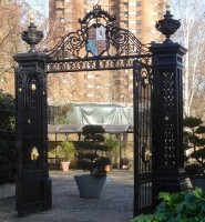
Today, little remains of Cremorne Gardens except a few street names and a small park close named Cremorne Gardens next to the river. This delightful, small open space has a paved section as well as a lawn. It is a tiny fragment of the original Cremorne Gardens but a fitting memorial to a place that provided entertainment for Londoners over many years. A couple of piers project into the river. These were originally landing stages for visitors arriving at the Gardens by river boat. Another souvenir of the heyday of the Gardens is a pair of wrought iron gates that stand in the present plot, but not in their original position, now built over. Small though it is, with its superb views of the Thames, the present Cremorne Gardens is a pleasant place to visit, within a short distance from the fashionable Kings Road.
FOR SEVEN YEARS, between 1994 and 2001, I treated dental problems at a dental practice in Golborne Road in North Kensington. The place was like a United Nations of bad teeth. My patients hailed from places including Brazil, the Caribbean, Spain, Zimbabwe, Ireland, England, Uganda, Portugal, St Helena, Italy, the USA, and North Africa. Most of the North Africans were from Morocco because many people from that country live in the housing estates that are close to Golborne Road. Although I used to make good use of the lovely shops and eateries on that road and nearby Portobello Road, I never bothered to walk northwest along Golborne beyond Trellick Tower (designed by Ernő Goldfinger and built in 1972), in whose shadow the road lies. Trellick Tower stands next to the Paddington Arm (branch) of the Grand Union Canal. At its base and running along about 450 yards of the west side of the canal, is the Meanwhile Gardens, which we visited for the first time last year, almost 20 years since I stopped working at Golborne Road.
Since the worsening of the covid19 pandemic in December 2020/January 2021, we have been on the lookout for shops where there are few other customers and there is plenty of space to avoid them. We have discovered that the Ladbroke Grove branch of Sainsburys, which is next to the canal towpath a few feet west of the bridge carrying Ladbroke Grove over the canal, is such a place. I have never been in a supermarket with such wide aisles; they are about 15 feet in width. It is also well-stocked, and the staff are helpful. The check-out area looks as if it has been designed with efficient ‘socialdistancing’ in mind. In addition, the large car park allows drivers to leave their vehicles free-of-charge for up to three hours. Do not worry, I do not have shares in Sainsburys.
After a spell of shopping, we tend to walk along the towpath that runs past the supermarket. Apart from joggers, who often feel (sometimes aggressively) that they have right of way over other pedestrians, and (usually considerate) cyclists, this path affords a pleasant and visually varied place to stretch one’s legs. Walking east from Sainsburys, soon the towpath runs alongside Meanwhile Gardens. There are several apertures through which one can enter the gardens from the towpath, and you can also gain access to the place from the streets that surround it.
The Meanwhile Gardens were conceived as a green space for the local, then generally low-income, mixed race community, in 1976 by Jamie McCollough, an artist and engineer (https://meanwhile-gardens.org.uk/history/16). They were laid out on a strip of derelict land, which once had terraced housing and other buildings before WW1, with financial assistance from the Gulbenkian Foundation and other organisations. They were, according to circular plaques embedded in the ground, “improved 2000”.
The gardens and the Sainsbury supermarket are in a part of London that used to be known as ‘Kensal Town’. Where the supermarket is now was part of an extensive gasworks, the remains of which can be seen nearby in the form of a disused gasometer. Residential buildings began appearing in the 1850s and many local people were employed in laundry work and at the gasworks of the Western Gas Company that was opened in 1845 (www.british-history.ac.uk/survey-london/vol37/pp333-339). In the 1860s and ‘70s, there was much housebuilding in and around the area now occupied by Meanwhile Gardens. Golborne Road was extended to reach this area in the 1880s. Many of its inhabitants were railway workers and migrants whose homes in central London had been demolished. The area was severely overcrowded and extremely poor. Few houses had gardens and the population density was high. After WW2, many of these dwellings were demolished and replaced by blocks of flats, including Trellick Tower, and smaller but salubrious shared dwellings. These residential streets contain the homes of many of my former dental patients.
A winding path links the various lovely parts of the garden including a sloping open space; a concrete skate park; a children’s play area; several sculptures; small, wooded areas; some interlinked ponds with a wooden viewing platform; plenty of bushes and shrubs; bridges; and a walled garden that acts as a suntrap. Near the latter, there is a tall brick chimney, the remains of a factory. The chimney was built in 1927 near to the former Severn Valley Pure Milk Company and the Meadowland Dairy. It was the last chimney of its kind to be built along the Paddington Arm canal and is completely dwarfed by the nearby Trellick Tower.
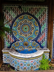
The Morroccan Garden, an exquisite part of the Meanwhile Gardens, was opened by Councillor Victoria Borwick on behalf of the local Moroccan community in 2007. It celebrates the achievements of that community and is open for all to enjoy. A straight path of patterned black and white tiling leads from the main path across a small lawn to a wall. A colourful mosaic with geometric patterning and a small fountain is attached to the wall, creating the illusion that a tiny part of Morocco has been transported into the Meanwhile Gardens. Nearby, there are a few seats for visitors to enjoy this tiny enclave in the gardens.
Words are insufficient to fully convey the charm of the Meanwhile Gardens, one of London’s many little gems. If you can, you should come to experience this leafy oasis so near the busy Harrow Road. In addition, a stroll along the canal tow path, where you can see an amazing variety of houseboats and plenty of waterfowl, is bound to be rewarding.
NEVILLE CHAMBERLAIN (1869-1940) has earned a poor reputation, mainly because of his unfortunate policy of appeasement with Nazi Germany in the late 1930s, which included the Munich Agreement in September 1938, which allowed the Nazis to invade the Sudetenland, the western part of Czechoslovakia. It took the disastrous German invasion of Poland before the then Prime Minister, Chamberlain, finally made Britain declare war on Germany.
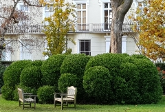
Today (24th of November 2020), we revisited Gunnersbury Park, which we ‘discovered’ for the first time a few weeks earlier. The front of the grand house, the Large Mansion, which was acquired by Nathan, a member of the Rothschild family, in 1835, has a terrace running next to its long rear façade. At each end of the terrace, there are two neo-classical archways, which we did not examine carefully on our first visit.
In one of these arches, there are two commemorative tablets inscribed in upper-case lettering. Both note the fact that Gunnersbury Park was opened for use by the public by “The Right Hon. Neville Chamberlain, M.P., Minister of Health”. The rest of the information on the tablets relates to the financing of the purchase of the park (from Lionel Nathan de Rothschild). One tablet commemorates that a quarter of the cost of the park, purchased by the Boroughs of both Acton and Ealing, was provided by Middlesex County Council. The other tablet recalls that in 1927, The Urban District Council of Brentford and Chiswick joined those of Acton and Ealing in the ownership and running of the public park. Thus, for a while, the park was managed by three different district councils. In 1965, Brentford and Chiswick became absorbed into the new Borough of Hounslow. That year, the Borough of Acton became part of the new enlarged Borough of Ealing. So, now the park is managed by two boroughs instead of three. According to a gardener, with whom we spoke, one of these boroughs has spent far more money on the park than the other.
Although he might have had good reasons for doing so, allowing the Germans to enter Czechoslovakia and overrun the Sudetenland seems unforgivable. However, and this by no means makes his policy of Appeasement more palatable, his opening the gates of Gunnersbury Park to the public has provided joy to visitors from near and far for many decades. I heartily recommend a visit to this lovely place filled with picturesque delights.
MUCH OF GREATER LONDON is green space, which has not been built on. According to one source of information, Greenspace Information for Greater London CIC (‘GiGL’; http://www.gigl.org.uk):
“Roughly 47% of Greater London is ‘green’; 33% of London is natural habitats within open space according to surveyed habitat information and an additional 14% is estimated to be vegetated private, domestic garden land.”
Of this ‘green space’, much is accessible to the public either free of charge (e.g. Regents Park) or for a fee (e.g. Kew Gardens). This piece is about an example of a type of green space in London that is open to a select few. I am referring to many of the gardens in London squares that are or were surrounded by residential buildings. Some of these (e.g. Gordon Square in Bloomsbury) have been taken over by local councils and are now open to the public in general. However, many of these garden squares contain gardens that may only be entered by people who are eligible to be able to pay a fee for a key to unlock them. Some of the squares confine those eligible for keys to residents in the square or in neighbouring streets. I know of one privately owned garden, that within Princes Square near Bayswater, which is open to anyone who can afford the annual fee. This square garden, being privately owned, is dependent for membership fees to ensure its maintenance. Those eligible to use the gardens within squares, whether privately or partially privately maintained, can be expected to pay something towards the maintenance of these often-beautiful local amenities.
Recently, a friend admitted us to the garden of Norland Square in Kensington. Like many of these limited access gardens, it is surrounded by formidable cast-iron railings. These railings were removed during the Second World War when metals required for war materials were in short supply. They were only replaced in 2007. Like most of these squares, the passer-by cannot see much within the garden beyond the railings because of hedges and other vegetation grown just within them to preserve the privacy of those using the garden. So, being allowed to enter Norland Square provided us a rare opportunity to examine the interior of one of these ‘secret’ gardens.
Norland Square takes its name from the Norland Estate, 52 acres of land bounded to the south by Holland Park Avenue, on the east by roads now named ‘Pottery Lane’ and ‘Portland Road’, on the west by the boundaries of the parishes of Kensington and Hammersmith (www.british-history.ac.uk/survey-london/vol37/pp276-297). The northern edge of the estate was roughly 200 yards north of the present Wilsham Street. The estate passed through several owners in the 18th century. They lived in a mansion, demolished long ago, which used to stand close to the present number 130 Holland Park Avenue. The name ‘Norland’ was used as early as 1599 to describe the ‘Northlands’, the land in the northern part of the Parish of Kensington (north of the present Holland Park Avenue), which includes the estate (www.rbkc.gov.uk/sites/default/files/atoms/files/Norland%20CAPS.pdf).
Writing in 1878, Edward Walford, author of a series of books called “Old and New London”, noted that during the reign of William IV, the then well-wooded estate belonged to one of the Drummonds, a family of bankers of Charing Cross. Prior to these occupants, the first to live in the former Norland House was Thomas Marquois (died 1802), ‘Professor of Artillery and Fortification’, who used the building as an academy to teach both civil and military subjects to sons of the gentry, who were hoping to join the British Army. According to the website about the Norland Estate mentioned above:
“Board and lodging, plus instruction in Greek, Latin, French, writing and arithmetic could be had for thirty guineas a year, but fortification, mathematics, navigation, drawing, geography, dancing, fencing and riding were all charged as extras. Marquois’ prospectus contains a plan of the academy and its grounds, which were indeed very well suited to his purposes. Besides the house itself there were stables, a manege or riding house, a fives court, a cricket ground, gravelled drives for hack riding, and an artificial ‘mount’ from which the various activities of the pupils could be kept under constant review.”
Marquois relinquished the property after only four years in 1765.
In 1825, fire destroyed Norland House. In 1838, Benjamin Lewis Vulliamy (1780-1854), clockmaker to the Crown, who then owned the Norland Estate, sold it and the ruins of the mansion to a solicitor Charles Richardson, who raised money to develop the estate for building purposes. The layout and design of the southern part of the estate, including Norland Square, was carried out by the architect Robert Cantwell (c1793-1859). The houses on Norland Square were leased to their first occupiers by Charles Richardson in 1842 and 1843.
Except for Norland Square Mansions on the south-west corner of the square, which has a few features slightly suggestive of art-deco style, the other houses surrounding the square are those built in the early 1840s. The mansion block occupies numbers 53 to 57 Norland Square. Interestingly, these plots do not figure in a list of the original lessees of the other plots in the square. Number 52, which neighbours the mansion block was leased to Robert Cantwell in 1842. A detailed map surveyed in 1865 shows that where Norland Square Mansions stands today, there were no houses but instead a garden extending between number 52 and a house, now no longer standing, on the corner of the square and Holland Park Avenue (then named ‘Uxbridge Road’). On a map dated 1913, the position of the mansion block was occupied by a school. This same building, which has a different ground plan to the current block of flats was still present on a detailed map surveyed in 1938. So, it would be reasonable to say that the mansion block was built after 1938.
Getting back to the present, we found that the ‘secret garden’ in the centre of Norland Square is both attractive and well-maintained. In addition to an extensive lawn furnished with occasional wooden benches and a table, there are plenty of shrubs and trees. There is a small well-equipped children’s play area at one end of the garden and tennis courts at the opposite end. While we spent time in the garden, a couple of elderly women were taking their daily walk around it and a young lady was exercising her dog. Areas like this are invaluable during periods of ‘lockdown’ during the current covid19 pandemic, offering lucky city-dwellers a welcome respite from being ‘confined to barracks’ and if they are fortunate to have a garden, they provide a much larger open space to ‘take the air’ than their own smaller patches. We were both grateful and happy to have been able to see and experience what is usually hidden from us by iron railings and curtains of dense vegetation.
THE BRENT IS a tributary of the River Thames. When I wrote about it elsewhere (https://londonadam.travellerspoint.com/33/), I mentioned that the two main tributaries of the Brent are Mutton Brook, which has its source in East Finchley and Dollis Brook, the subject of this piece.
“Dollis Brook rises on Moat Mount Open Space in Mill Hill … flows eastwards through Totteridge Fields … then through fields and open spaces to King George V Playing Fields. The brook then turns southwards and forms the eastern boundary of Totteridge past Totteridge Lane near Totteridge and Whetstone tube station … continues south through Woodside Park (where it merges with Folly Brook) and West Finchley … Dollis Brook then passes under Dollis Road and through Windsor Open Space to the Great North Way (A1). Near Bridge Lane in Hendon it merges with Mutton Brook to form the River Brent.”
One sunny Sunday morning, we joined the footpath that runs alongside the winding Dollis Brook at a bridge crossing it. Halfway across the bridge is the boundary between Laurel Way in the N20 postal district and Laurel View, which is in the N12 postal district. The footpath, which has a well-made surface, free of mud, is part of the Dollis Valley Greenwalk. By heading north, we entered an area named Whetstone Stray. During the 19th century:
“Whetstone Stray was once part of the Baxendale Estate. Joseph Baxendale had taken over Pickford Brothers, and the area of Whetstone Stray had been used as grazing ground for the 1000 or so horses used in their carrying business. … On the death of Joseph Baxendale in 1872, there were problems over the division of the land.” (https://whetstoneallotments.co.uk/)
The origin of this area’s name is uncertain, but it is likely to have something to do with either grazing horses or with land whose ownership is uncertain or land on which horses could be ‘strayed’. Whatever its meaning, this corridor of meadows and trees along which the Dollis Brook follows its very wiggly course makes for a pleasant place to walk. Although it was far from crowded, there were plenty of other people enjoying it. What struck us was that the folk that we met were a cosmopolitan bunch. We heard snatches of conversation in a wide variety of languages. This was a complete contrast to the meadows at Runnymede, which we had visited the day before. There, apart from a few tourists from the Indian subcontinent, most people appeared to be of Anglo-Saxon origin.
The northern end of Whetstone Stray is where it meets Totteridge Lane, close to Totteridge and Whetstone Underground Station. The name ‘Totteridge’ is probably derived from the Anglo-Saxon root ‘tot’, meaning an ‘elevation’, and the English word ‘ridge’. An alternative etymology is that the name comes from the name of a Celtic deity ‘Taith’. The Underground Station, which is on the High Barnet branch of the Northern Line, is above ground and a simple building of indifferent architectural merit. It opened as a station on the Great Northern Railway in 1872 and became part of the Underground network in 1940. The Waiting Room Café nearby provided acceptable coffee.
The Dollis Brook continues north after passing beneath bridge carrying Totteridge Lane. The Greenwalk also continues in the same direction. Whereas the Whetstone Stray is a fairly narrow densely vegetated stretch of land, the land through which the path continues is wider and less full of trees. It runs through open fields and parallel to the tracks of the Northern Line, which is almost hidden from view by bushes. However, the roar of passing trains is easily heard and the trains can be seen through gaps in vegetation. The path splits into two soon after leaving Totteridge Lane. One path closer to the Dollis Brook is for cyclists and another further from the still winding stream is reserved for pedestrians. The narrow brook is often hidden by the dense growth of trees and bushes alongside it. However, it can be seen that the riverbed makes many tight U-turns along its course.
After passing Brook Farm Open Space, the brook begins flowing from the west. Brook Farm no longer exists. Next, our path skirted the south edge of a vast open space called Barnet Playing Fields. We ended our outbound walk at Barnet Table Tennis Centre and then retraced our steps. As we walked towards Totteridge and Whetstone Station, the horizon was dominated by a less than attractive tall building. This was built as the headquarters of British Ever Ready Electrical Company. Then, it became offices for the London Borough of Barnet and was known as ‘Barnet House’. Currently, its future hangs in the balance while developers fight to get permission to get it converted to 256 flats, some of which would be amongst the smallest in London (some as small as 16 square metres). The building was completed in 1966 to the designs of R Seifert and Partners, who designed Centre Point close by Tottenham Court Road Station.
In summary, the walk beside Dollis Brook is yet another example of London’s wealth of pleasant open spaces where city dwellers can enjoy some of the pleasures of the countryside without leaving the metropolis.
UNLIKE MANY PLACES IN ENGLAND, Penzance in Cornwall did not get a mention in the Domesday Book published in 1086 although there is archaeological evidence of a bronze age settlement in the area. The first written mention of the town is in a document dated 1284, when it was listed as ‘Pensans’. The etymology of the town’s name derives from the Cornish words ‘penn sans’ meaning ‘holy headland’.
We discovered recently, on our first visit to the town, that Penzance in the far south-west of the British Isles is very pleasant and full of interesting buildings and other attractions. One of these is the long seafront promenade from which the visitor can see nearby Newlyn in one direction and St Michael’s Mount, Britain’s answer to France’s Mont St Michel, in another. Incidentally, Penzance is further west than anywhere in mainland France.
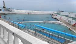
A row of poles carrying large flags, on which pictures of a diving ladies, dressed in old-fashioned blue striped bathing dresses, were printed, attracted our attention. The flags were fluttering vigorously in the strong breeze. They were placed next to the wall surrounding a large triangular open-air swimming pool two of whose walls project out into the sea. The pool was divided into two sections, one with a greater area than the other. Plenty of people were swimming in both parts. The design of the pool immediately made us think that it had elements suggestive of the art deco style that was popular in between the two World Wars.
The pool is known as the Jubilee Pool. A plaque at its main entrance informs that the pool was opened on the 31st of May 1935 (during the year of the Silver Jubilee of the reign of King George V), confirming our suspicion that it was built in the era of art deco. A website (https://historicengland.org.uk/listing/the-list/list-entry/1221190) contains the information that the pool was built to the designs of the Borough Engineer Captain F Latham, and it adds that the pool:
“… is now the finest surviving example of its type with the exception of the Saltdean Lido in Brighton (listed grade II). In Europe, lidos such as the Piscine Molitor in Paris of 1929 were the first to adopt the modernist style in order to embody the worship of sunlight and physical fitness. The seaside lido manifested the transformation of sea bathing in the 1920s from a predominantly health activity into a leisure activity, and because it was freed from the constraints in planning of more conventional pools it presented local authorities with the opportunity to emulate Continental fashions.”
The water in the two sections of the pool differs in temperature. In the lager part of the bath, it is unheated but in the smaller part, it is heated. Currently, a bather pays up to £4.25 to swim in the unheated section, and up to £11.75 to swim in the ‘Geothermal Pool’, whose water is between 30 and 35 degrees Celsius (https://jubileepool.co.uk/tickets/). Despite locals receiving a discount on ticket prices, many choose to swim in the sea amongst the Battery Rocks that surround the pool and the extension of the promenade that runs along the eastern edge of the bath. One local, who was dressed in a wet suit and had just been in the sea thought the ticket prices were a bit steep and told us that during September, the end of summer, the sea is actually quite warm.
The Geothermal Pool is filled with salt water heated by geothermal energy. The idea of installing this feature derives from Charlie Dixon, who in 2010:
“…had just returned from a trip to New Zealand where he had bathed in geothermal pools … Ten years and a £1.8m funding package later (not to mention an incredible amount of work by the Jubilee Pool Directors and staff) the first geothermally heated pool of its kind in the UK opens to the public on 1st September 2020 …
… The system operates by extracting warm water from one geothermal well (410m deep – the height of one and a half Eiffel Towers!!), taking heat out of that water using heat pumps and distributing it to the pool via a heat exchanger, before re-injecting the cooler water back into the ground. This combined system means that the temperature of the pool can be sustained with a very low carbon footprint. The initial pool heating results suggest that it’s about 80% geothermal but ultimately all the energy is coming from our geothermal well. We are using the heat pumps to concentrate that energy to the exact temperature required for the pool.” (https://jubileepool.co.uk/pool-info/geothermal/).
Although the Jubilee Pool geothermal system is the first of its kind in the UK, it was not the first pool or lido to use naturally heated water. The Romans heated the water at Bath with naturally warm spring water.
We wandered along the eastern side of the pool towards a carved stone obelisk that overlooks the triangular pool and the expanse of Battery Rocks. It stands on the site of a gun battery that was built in 1740 when Britain’s relations with Spain deteriorated. The obelisk, a war memorial, was designed by Sir Edward Warren and erected in 1922. It was unveiled by Mrs Bolitho on the 14th of May 1922. She was the wife of Thomas Bedford Bolitho (1835-1915), a Cornish politician (Liberal Unionist MP), banker, and industrialist, of Trewidden (Cornwall). Bolitho is a western Cornish surname and that of a prolific writer and biographer, Hector Bolitho (1897-1974), whose biography of Jinnah, the creator of Pakistan, was published in 1954. Hector was born in New Zealand and migrated to the UK in about 1924. Hector’s grandfather emigrated from Cornwall to New Zealand. It would be interesting to know whether Hector and Thomas were related, even remotely.
We saw plenty of folk bathing in the sea near the pool. They sheltered behind towels that flapped about in the breeze whilst they slipped in and out of their bathing suits. None of them, with whom we spoke, complained about the water’s temperature. In addition to humans enjoying the environment I spotted several cormorants contemplating the sea from their perches on the rocks. The Jubilee Pool and the rocks near it are some of the lovely features that make a visit to Penzance delightful.