
Portraits on walls
Princess Di took tea here sometimes
At this small café

Portraits on walls
Princess Di took tea here sometimes
At this small café
JOHN LINNELL (1792-1882) painted the Kensington gravel pits in about 1811. The picture hangs in London’s Tate Britain These pits lay alongside Bayswater Road and Notting Hill Gate. They provided gravel for building projects in England and as far away as Imperial Russia.

Today, the pits no longer exist. They have been built over, but street names such as St Petersburg Place and Moscow Road commemorate the fortunes made by selling gravel from these pits to Russia.
You can discover more about this and much more about Paddington and Kensington and points further west in my book “BEYOND MARYLEBONE AND MAYFAIR: EXPLORING WEST LONDON” (see https://www.amazon.co.uk/gp/aw/d/B0B7CR679W/

AT THE TATE Britain, I visited the exhibition of paintings and drawings by the artist Walter Sickert (1860-1942). Amongst these, I was interested to see one which depicts a stretch of the platform at what is now Bayswater Underground station. In Sickert’s time, this station was called ‘Queens Road (Bayswater)’. Painted in 1914-15, this station was the closest one to his then home in Kildare Gardens (off Westbourne Grove). In the painting there is a man seated on a bench beneath an advertisement for Whiteleys. This was a department store, whose history I have described in my book “Beyond Marylebone and Mayfair: Exploring West London”*. Here is a shortened extract:
“Queensway was the home of a large department store called Whiteleys. Created in nearby Westbourne Grove by William Whiteley (1831-1907) in 1863, it moved into its large home on Queensway in 1911. After going through various transformations over the years, eventually becoming a shopping mall with restaurants and a cinema, it closed in 2018 … Since 2018, developers have removed the building’s innards whilst preserving its outer walls. The aim is to create a new shopping area along with a hotel and residential units. The final product might be interesting as its architects are from the team led by Norman Foster.”
Between 1968 and 1970, I was at north London’s Highgate School studying in preparation for my A-Levels (examinations to gain admission to university). One of my subjects was biology. I decided to enter the school’s Bodkin Prize biology essay competition. For some long-forgotten reason, I chose as my essay topic the life of woodlice. Seeing the above-mentioned painting by Sickert, reminded me of this essay. Being a keen researcher, even in my late teens, I discovered that there was a detailed book on my chosen subject, and this was available for perusal in a science library (the National Reference Library for Science and Invention), which was part of what has now become known as The British Library. In the late 1960s, when I required the book, the library’s collection was housed in a part of what had been the former Whiteleys department store on Queensway. It was a peculiar place: the bookshelves and readers’ desks were arranged on several layers of curved galleries surrounding a circular open space on the ground floor. Above the circular space, there was a spectacular, circular, large diameter, glazed skylight. The book I consulted was in French, and I spent a whole day laboriously translating it and making notes for use later. ‘cloporte’ is the French for ‘woodlouse’, just in case you are wondering. I believe that one visit was sufficient for me to collect what information I needed.
In December 1967, there was a debate about the state of the British Museum Library (now British Library) in the House of Lords. During a long speech, Viscount Eccles (1904-1999) mentioned the library where I had read about woodlice:
“Learned societies and famous men in the arts and the sciences have been shocked by the substance and the manner of the Government’s decision concerning the Library … An example of how the Act works can be seen in what has happened to the National Reference Library for Science and Invention. For years the former Trustees were frustrated by the delays and niggardliness of previous Governments in finding accommodation for this growing section of scientific material, not to mention the disgraceful shilly-shallying over the Patent Office Library. The position grew so desperate that the Trustees decided to gather together part of the material in temporary premises in Bayswater—admittedly very unsatisfactory…” (https://api.parliament.uk/historic-hansard/lords/1967/dec/13/british-museum-library)
I visited the library a year or so after that speech. As for my essay, I won 2nd prize: 15 shillings (75pence) to spend on books, which was reasonably generous at that time. 2nd prize might impress you for a moment until I reveal that I was one of only two entrants. The 1st prize was won by my classmate Timothy Clarke. His older brother, Charles Clarke, not only became Head of School but later served as British Home Secretary between 2004 and 2006.
Returning to Whiteleys, I began visiting it regularly after 1993, when I began living nearby. Then, as described already, it had become a shopping mall. The galleries, which had once served as a library, were lined with shops and eateries, as well as a cinema. But that is all in the past, and what was once Whiteleys is now a building site. I doubt that Sickert would have been pleased if he were able to see it today.
* My book is available from Amazon:
THERE IS SOMETHING curious about a small building on Kensington Park Road (near to London’s Portobello Road). Above its centrally located, west-facing front door, there are three tall windows topped with semi-circular arches. In each of these windows, there is a circular pane of glass painted white.
If you look at the circular panes carefully, you will notice that, almost obscured by the paint, there is a six-pointed star, the Jewish Magen David. Inside the building, there is a large hall flanked by galleries at the first-floor level. The galleries are supported by metal columns topped with decorative capitals. High up on the east wall of the building, there is a circular stained-glass window. The glass depicts a Magen David: it has not been concealed by paint.

Did you know that this building, now much modified, was one of two synagogues in the Bayswater/Notting Hill area of west London? The other, still functioning, is on St Petersburgh Place near Bayswater Road.
I will not tell you any more about these two synagogues, one defunct and the other working, and west London Jewish communities, because you can read about them ( and much more) in my book “Beyond Marylebone and Mayfair: Exploring West London”. You can buy the book from Amazon (https://www.amazon.co.uk/BEYOND-MARYLEBONE-MAYFAIR-EXPLORING-LONDON/dp/B0B7CR679W/), or if you prefer to support independent bookshops, you can order a copy from a lovely bookshop near the former synagogue on Kensington Park Road: Lutyens & Rubinstein (21 Kensington Park Rd, London W11 2EU).
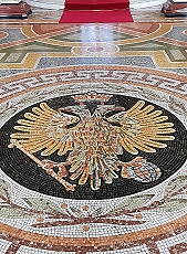
THE SYNAGOGUE IN Bayswater’s St Petersburg Place, a gothic revival edifice, looks no more exotic or out of place than the Victorian gothic Church of St Matthew built 1881-82 on the same street. In fact, it is another building to the north of these two that is unashamedly exotic in appearance: Aghia Sofia (Saint Sophia), the Greek Orthodox cathedral on Moscow Road. This domed building constructed for a community of prosperous Greek merchants was designed by John Oldrid Scott (1841-1913 and completed in 1877.
The first Greeks began arriving in London at the end of the 17th century. By the late 19th century (according to the website http://www.stsophia.org.uk), members of the Greek community in London:
“… were distinguished for their industry and their business acumen, and … soon became for the most part financially independent. They now wished to enjoy a more comfortable life, both for themselves and their families. They kept their offices in the City, but took up their private residences in other parts of London. The favourite districts were Lancaster Gate and Bayswater. These districts, which today are almost in the centre of the unending metropolis, were then only on its fringe, and to go from the City to Hyde Park, for instance, was considered a long excursion, which was undertaken, normally, only on holidays, as a relaxation and in order to enjoy the fresh country air.
After three decades had passed from the founding of the Church of Our Saviour [in the City near London Wall], no one any longer had his private residence in the City; and whereas previously all had lived within a very short distance of the Church, now five whole miles divided the Church from the residential district of the faithful.
For the men, in particular, who had every day to make the journey to the City, a tiring one with the means of transport then available, it was hard to undergo the same fatigue on Sundays also, when they were supposed not only to perform their religious duties, but also to rest from the labours of the week. Moreover, the number of the Greeks had greatly increased, and there was scarcely room for them all in the Church then existing. These various difficulties made it imperatively necessary to build a new larger Church, situated closer to the residences of the Brothers.”
Just as the Jewish people, who had also settled in Bayswater, far from the older synagogues in the City and established a new one near their new homes, the Greeks did the same. Moscow Road’s St Sophia’s church interior is filled with icons and other religious paintings is colourful and attractive. Instead of frescos on the walls, which were believed to be at risk of damage from London’s damp climate, the church’s interior is lined with mosaics. Some of the earliest of these were designed by Arthur George Walker (1861-1939). In 1926, the Russian born mosaic artist Boris Vasilyevich Anrep (1883-1969) created some more mosaics for the cathedral. The marble floor of the edifice is also attractive.
BETWEEN LANCASTER GATE and Queensway, at the corner of Bayswater Road and Leinster Terrace, there stands number 100 Bayswater Road, which was built in 1820 and was the home of the author JM Barrie (1860-1937) from 1900 onwards. It was here close to Hyde Park that he wrote “Peter Pan” as a play in 1904 and as a novel in 1911. It is worth wandering along Leinster Terrace and its continuation Leinster Gardens.
Almost opposite Barrie’s home but a little north of it is number 74 Leinster Terrace. It was here that the American author Francis Bret Harte (1836-1902) lived and died. He had settled in London in 1885. Northwest of this house and on the south corner of the Terrace and a passageway called Craven Hill Gardens, there is a Greek restaurant that has long intrigued me. It is called Mykonos and has the Swedish words “Kalle på Spången” written on it in several prominent places. This is the name of a well-known Swedish film made in 1939, in which a character called Kalle owns and runs a pub. Formerly called Zorba’s, it was closed in 2017 because of hygiene problems. Now (2022) called Mykonos, it looks as if it is no longer in business. It also bears a sign with the name of a Swedish County, Skåne, in which the inn that figures in the film was located. Unless it was to attract Swedish tourists, I am not clear why this Greek restaurant associated itself with a Swedish film. North of the restaurant, Leinster Terrace becomes Leinster Gardens.

Much of the west side of Leinster Gardens is lined by Victorian terraced housing with neo-classical features. Close examination of numbers 23 and 24 reveals that unlike their neighbours on either side, the windows do not have glass panes. Where the windowpanes should be, there are painted blanks. These two houses in the terrace were demolished when the subterranean London Underground lines were being built in the 1860s. The façades of numbers 23 and 24 have no building behind them. They hide a ventilation shaft that provides air to a section of the Circle and District lines running between Bayswater and Paddington stations. By walking along Craven Hill Gardens west to Porchester Terrace, which runs parallel to Leinster Gardens, you can see the featureless rear of the fake façade and beneath it you can just about see the tracks of the railway.
Moving north along Porchester Terrace, you can see number 30, which is adorned with a sculpted lion and some lion heads. It was here that the family of the author Wilkie Collins (1824-1889) moved from Hampstead in 1830, when he was six years old. Collins’s father, William Collins (1788-1847) was a painter, whose paintings at one time exceeded those of John Constable in value. Another artist, John Linell (1792-1882), a friend of William, lived a few doors north of this at number 36 from 1830 until 1851. Many years later, this house was occupied by the photographer Camille Silvy (1834-1910) between 1859 until 1868.
Not far away from Porchester Terrace and close to Queensway, a sculpted bust of a man in a distinctive helmet stands on a plinth at the corner of Inverness Terrace and Porchester Gardens. This depicts Albania’s most highly regarded hero George Kastrioti Skanderbeg (1405-1468), who defended his native Albanian territory from the invading Ottoman armies for a few years.
Between Peter Pan’s birthplace and the monument to Albania’s national hero is a few feet more than one third of a mile on foot. Yet in this short distance, there is much to see. This is what makes London such a fascinating place in which to live.

THE WESTERN END of Oxford Street is at Marble Arch. Beyond the latter, its continuation becomes Hyde Park Place and then, after 620 yards it becomes Bayswater Road, before reaching Notting Hill Gate, and then Holland Park Avenue. Oxford Street and its continuation westward follow the probable course of a road or track named by the Romans as Via Trinobantia. It ran from Colchester via London to Silchester (in Hampshire), which was a capital of the Atrebates tribe. According to Ralph Merrifield in his “Roman London” (published 1969), the Roman thoroughfare ran due west from Oxford Street, along what is now Bayswater Road to Notting Hill Gate. After that, it changed direction so that it headed directly to what is now Staines. Merrifield wrote that its course:
“… is closely followed by Holland Park Avenue and Goldhawk Road, until the latter turns sharply towards Chiswick. The Roman road is then followed by two lesser modern roads, Stamford Brook Road and Bath Road, and crossed Acton Green where it has been obliterated by the railways. Half a mile further west it is represented by Chiswick Road, which leads to Chiswick High Road…”
On a map drawn by Ralph Agas (c1540-1621) in the 16th century, the part of the Roman highway known now as Oxford Street was marked “The Waye to Uxbridge”. At that distant time (1561), the western edge of London was as far east as Farringdon, which follows part of the now lost Fleet River. This was the case except for riverside strip of buildings along the north bank of the Thames to Westminster. Oxford Street, so named in the 18th century, has had other names such as the ‘Tyburn Road’, ‘Uxbridge Road’, and ‘Oxford Road’.
A sign on a lamppost on Bayswater Road near to Lancaster Gate Underground station reads “A402 was A40”. The road running along the northern edge of Hyde Park and Kensington Gardens was designated in 1923 as ‘The London to Fishguard Trunk Road (A40)’. After the A40 was re-routed, part of it running along the elevated Westway (completed in 1970), the section of the original A40 (and much earlier the Roman road), which ran between Marble Arch and the westernmost end of Goldhawk Road was re-designated the A 402.
Until the early 19th century, what is now Bayswater Road and its western continuation ran through open country, passing Hyde Park, a royal hunting ground established by King Henry VIII in 1536 (and opened to the public in 1637). Before the park was established, the journey west of what is now marble Arch would have been through a rustic landscape and travellers would have been at risk from attacks by robbers, Today, the greatest risk faced by users of Bayswater Road is delay caused by traffic congestion.
LANCASTER GATE IS ten minutes’ walk or a three-minute bus ride away from where I have lived for over 29 years. I have passed it innumerable times, yet I have never explored it. Yesterday, the 30th of October 2021, I decided it was high time that I took a closer look at the place. The name refers to an entrance to Kensington Gardens as well as a nearby network of streets. The network includes a long street extending from east to west between Craven Terrace (near Paddington Station) and Leinster Terrace. The section of road between Craven Terrace and Bayswater Road is also called Lancaster Gate. Midway along the long east-west section of the Gate, there is a wide street, almost a square or piazza, that leads to Bayswater Road. This rectangular piazza is south of a rectangular loop to the north of the east-west section, in the centre of which there is a 20th century building called Spire House. If this sounds confusing, then please look at a map!

What I have called the ‘piazza’ opens out onto Bayswater Road. In the middle of it, there is a monument topped with the weather worn sculpture of a seated child, probably male. The sculpture sits above a bas-relief depicting the western façade and the dome of London’s St Paul’s Cathedral. Below, on the south side of the pedestal, there is a bas-relief, depicting the face of a man with a bushy moustache and a long luxuriant beard. Weather and/or pollution has worn away details from his portrait. At first sight, I thought that it was a representation of George Bernard Shaw as an old man, but it is not. It is, according to the almost undecipherable inscription beneath it, the face of Reginald Brabazon, the 12th Earl of Meath, who lived from 1841 to 1929. The words on the plinth include that he was “a patriot and a philanthropist”.
Brabazon was Anglo-Irish and born in London (https://en.wikipedia.org/wiki/Reginald_Brabazon,_12th_Earl_of_Meath). Educated at Eton, he became a diplomat, but resigned from the Diplomatic Service in 1877. Ten years later, he joined the House of Lords as a Conservative peer. Reginald and his wife, Mary, devoted much of their lives to relieving human suffering and ameliorating social conditions. Amongst his many good works was the establishment (in 1882) of a charity called the Metropolitan Public Gardens Association, whose aim was the preservation of public open spaces and the creation of new ones, which might explain why the memorial to him faces Hyde Park. The Portland stone monument, known as The Meath Memorial, was designed by Joseph Hermon Cawthra (1886-1971) and unveiled in 1934.
A few feet north of Brabazon’s memorial, which stands on a wide traffic island, there is a slender stone column topped by an ornate octagonal structure surmounted by a shiny metal crucifix. The base of this column reveals that it is was built as a WW1 memorial. In the pavement between the two memorials, the City of Westminster has set several informative panels about the history of Lancaster Gate. The development of Lancaster Gate, originally known as ‘Upper Hyde Park Gardens’, began in the late 1860s, an initiative of the developer Henry de Bruno Austin. Many of the houses he built have rich stucco facades and porches supported by neo-classical style pillars. Quite a few of them are now hotels. These buildings are interspersed with a few newer buildings, presumably where the originals were bombed during WW2. However, most Lancaster Gate’s houses are those built in the 19th century.
The name Lancaster Gate was chosen to honour Queen Victoria, who was amongst many other things, the Duchess of Lancaster.
Before Lancaster Gate was developed, it was mostly agricultural land. Until 1775, the composer, actor, botanist, and playwright John Hill (1716-1775) had his Physic Garden here. By 1795, visitors flocked to the area to enjoy the springs and fresh air at the Bayswater Tea Gardens, which later was renamed the Flora Tea Gardens, and then the Victoria Tea Gardens. This establishment closed in 1854.
At the southern end of the loop and towering above the plaza with its two monuments, there is a tall church tower with a spire. This is all that remains of the Christ Church, Lancaster Gate, whose construction began in 1854. The last service to be held in the church was in 1977, by which time the roof was badly infected with dry rot. The church was demolished, but the tower retained. Where the body of church stood, there is now a block of flats. Opened in about 1983, it is appropriately named Spire House. Its 20th century architecture is quite attractive and contrasts dramatically with the stuccoed Victorian buildings that face its west, north, and east sides. Spire House has external concrete supporting pillars that suggest an updated version of the flying buttresses used in mediaeval church architecture.
Lancaster Gate is a relatively unspoilt example of mid-Victorian town planning and worthy of a short visit. While walking around the area, I only spotted one blue plaque, commemorating a resident worthy of note. It recorded that the “Chemical Scientist” Sir Edward Frankland (1825-1899) lived in Lancaster Gate from 1870 to 1880. He was one of the founders of organo-metallic chemistry and a discoverer of Helium. Also, he took an active interest in the problem of pollution of rivers and the quality of London’s water. I trust that he would be pleased to know that fish have returned to London’s once filthy River Thames.
After exploring Lancaster Gate and its sea of stuccoed facades, head east into Craven Street, where you can find several cafés and at least one pub.
GUILAN IS A NEW cafe on the corner of Moscow Road and St Petersburgh Place in London’s Bayswater. I have walked past the building numerous times over the past more than 25 years, but until today I missed seeing something on the building.

Above the ground floor windows there are a number of sculpted heads of cattle. I had never noticed these before.
On looking at a map produced in the 1950s, I discovered that the building was then a dairy. An older map revealed that it was ‘The Aylesbury Dairy’. A search on the Internet informed me that this building was the head office of the company, which had another branch not far away. So, the cattle heads are a souvenir of the building’s time as a dairy.
The new café in the former dairy is across the road from Aghia Sofia, a Greek Orthodox church. The cafe is elegant and serves good coffee and tasty pastries including a croissant flavoured with za’atar. I have no idea from which dairy the milk is supplied to Guilan, but you can be sure it is not the Aylesbury Dairy.
SOME ‘POSHER’ JEWISH people in west London tended to live around Bayswater. These prosperous members of the Jewish community arrived in Bayswater in the 19th century as the district began to be urbanised. Many of them had drifted westwards from Bloomsbury and the City (www.british-history.ac.uk/vch/middx/vol9/pp264-265). This migration placed them at an inconvenient distance from the synagogues they had been used to attending. So, in 1863, Bayswater Synagogue (at corner of Chichester Place and Harrow Road) was consecrated. This new place of worship was a branch of both the of the Great Synagogue (in the City north of Aldgate) and the New Synagogue (originally near Leadenhall Street, and then later in Great St Helens Street). Like so many Jewish buildings in mainland Europe, this synagogue was destroyed by the forces of Nazi Germany, during WW2.
In 1879, an offshoot of the now demolished Bayswater Synagogue was consecrated in St Petersburg Place, a short distance from the main road known as Bayswater. This, The New West End Synagogue, is now one of the oldest surviving functioning synagogues in Great Britain. At first sight, you might easily be mistaken for thinking that the huge red brick building with Victorian gothic architectural features, a rose window, and twin bell towers, is a church. And maybe that was the intention of the community that commissioned the building. Upwardly mobile Jewish people in Victorian England might well have preferred not to advertise their religious beliefs too much in a society that then had many prejudices against Judaism and other non-Christian religions. The synagogue in St Petersburg Place looks no more exotic or out of place than the Church of St Matthew a few yards north on the same street. In fact, it is another building to the north of these two and within sight of them that is unashamedly exotic in appearance, Aghia Sofia, the Greek Orthodox cathedral on Moscow Road, which was consecrated only three years after the synagogue.
The desire of some Jewish people to ‘meld’ seamlessly with British ‘high society’ was not confined to England. Amos Elon writes about this in his inciteful book about the ‘emancipation’ of Jews in Germany, “The Pity of it All”, and what a dreadful fate it led to. It is my impression that amongst the few Jewish people, mostly of British and German origin, living in Victorian South Africa, there was the belief that economic and social advancement was not hindered by being somewhat discreet about their religious beliefs. This changed during the final few decades of the 19th century when many Jewish people began arriving from parts of the former Russian Empire, many from what is now Lithuania. Often much poorer than their co-religionists, who were already well-established in South Africa, they were far less reticent about expressing their religious beliefs and critical of the ‘established’ Anglo-German Jewish community, who had, in their eyes, become rather too lax about Jewish religious observance.
Returning to Bayswater and its mainly prosperous Jewish families, we can now travel less than a mile northwest to reach the northern end of Kensington Park Road, close to Portobello Road, in nearby Notting Hill, to reach the site of another, now disused, synagogue. This building, still standing but now repurposed, was not designed to mislead the onlooker into believing it was a church. As was the case in South Africa during the last few decades of the Victorian era, large numbers of Jewish people began arriving in London from Eastern Europe, and many of them settled in the crowded East End. In 1902, A Jewish Dispersion Committee, set up by the (Jewish) banker and philanthropist Sir Samuel Montagu (1832-1911), tried to attract some of these new arrivals to settle in areas away from the East End, like Notting Hill (www.british-history.ac.uk/vch/middx/vol1/pp149-151).
The former Notting Hill Synagogue at numbers 206/208 Kensington Park Road was opened in 1900 (www.jewishgen.org/jcr-uk/london/notting_fed/Index.htm), a little ahead of the formation of the above-mentioned committee. Presumably, it was worth opening because there must have been sufficient Jewish presence in the neighbourhood. By 1905, it had 281 members and ten years later, there were 250. Its ritual was Ashkenazi Orthodox, the same as that at the New West End Synagogue, but the congregants were less wealthy than those who attended the latter. Many of them were market stallholders or artisans, such as tailors and shoemakers (http://www.ladbrokeassociation.info/Churchesandotherreligiousbuildings.htm#Synagogue). They lived in what were at the beginning of the 20th century far less salubrious dwellings than many of those, who worshipped in St Peterburg Place. Although I do not know for certain, I doubt there was much socialising between the Jewish communities of Bayswater and Notting Hill.
The Notting Hill Synagogue was housed in a former church hall. Its memorial stone dated the 27th of January 1900 was laid by Sir Samuel Montagu. Although it was a discreet building externally, its interior with galleries for the women and girls was elaborate and attractive as can be seen in old photographs (www.jewishgen.org/jcr-uk/london/notting_fed/Photographs.htm). We have walked past it many times without realising it was once a place of worship until a friend told us recently about its former incarnation.
During WW2, the synagogue was severely damaged by a German bomb. It was restored and reconstructed. During the Notting Hill race riots in the late 1950’s, during the time that the fascist Oswald Mosely (1896-1980) was campaigning as a candidate in the election for the parliamentary seat of the local constituency, Kensington North, he set up his office close to the synagogue. On the 31st of January 1959, one of his supporters daubed the synagogue with the words used by the Nazis: “Juden raus”. Despite these traumatic events, the synagogue continued to thrive until the 1990s, when the size of the local Jewish population had declined. Rabbi Pini Dunner (born 1970), who had been invited to help in performing the ritual in 1992, when the synagogue, under the leadership of its charismatic Stuart Schama, was falling into decline, wrote:
“Notting Hill Synagogue was nothing like any shul I had ever seen. The congregants consisted of a motley group of mainly octogenarian men, characters out of some East End Jewish sit-com, each with his own catchphrase, many of them not quite sure why they were there week after week.”
(https://rabbidunner.com/memories-of-stuart-schama/).
The synagogue then closed, and amalgamated with the Shepherd’s Bush, Fulham & District Synagogue. Since its closure, the synagogue has been used as a ‘health club’. Currently (March 2021), the building bears the name ‘Teresa Tarmey’, a company that supplies various treatments (www.teresatarmey.com/).
The transformation of the former synagogue into a trendy beauty salon reflects that of Notting Hill from a relatively impoverished area into a prosperous area with high property prices, which is beginning to make Bayswater seem less attractive in comparison. The synagogue in St Petersburg Place continues to thrive. One of my cousins, who lives many miles from it, told me that it was well worth travelling to because its congregation is vibrant and life-enhancing, which is good to know because the mainly residential area surrounding the synagogue is usually rather sleepy.
