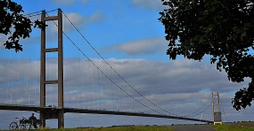
MY WIFE WAS studying to become a chartered accountant in the mid-1970s. As a trainee, she was required to carry out audits for her company in many parts of the UK. One of these was the building site where the Humber Bridge, which crosses the River Humber and links north Lincolnshire with the East Riding of Yorkshire. The bridge has a long span suspended between two tall concrete towers. When my (then future) wife arrived to audit the accounts of the entity involved in the construction, the towers had already been erected but there was no span for carrying the roadway across the river. A precarious looking cradle, attached to cables suspended between the towers, was used to cross the river. Some of the construction workers used it to traverse the Humber.
Being a keen and extremely assiduous trainee accountant, my wife wanted to inspect the construction site in considerable detail. Respecting her desire to examine the site properly, the managers on the site ensured that this happened. After carrying out the audit, she returned to London satisfied and has always held a special affection for the then yet to be completed bridge.
It was only a few years after my wife qualified as a chartered accountant that the bridge was eventually opened for use in mid-1981. The bridge is 1.38 miles in length and is currently the world’s eleventh longest bridge of this design (https://en.wikipedia.org/wiki/Humber_Bridge). A small toll is payable to cross it, which is what we did while travelling from Yorkshire to Lincolnshire in September 2021. After driving across the elegant, impressive bridge, we drove through the small town of Barton-upon-Humber to reach a bridge viewing park. There, my wife and I enjoyed snacks whilst gazing at the bridge for which she still harbours a soft spot. There is no accounting for taste!
TODAY THE MAIN roads leading from London west, the A4 and the M4, run more or less parallel from Hammersmith west towards Slough and then beyond. Before these roads were modernised, or in the case of the M4 and, existed, the old road from London to Slough and points further west ran through the village of Colnbrook, and onwards to Bath. This was long before London’s Heathrow Airport came into existence. Today, the centre of Colnbrook, bypassed by both the A4 and the M4, lies 1.2 miles west of the western perimeter of the airport. Aeroplanes coming into land fly low over Colnbrook because they are within a minute or two of touching down on the runways. Despite being sandwiched between the airport and the ever-expanding town of Slough and having some new housing, Colnbrook retains many features of a rural English village.
With a bridge crossing the River Colne, a tributary of the Thames, Colnbrook was an important staging post on the coach road between London and the west. An old milestone near The Ostrich pub marks the halfway point between Hounslow (west London) and Maidenhead. A modern sign next to it informs that the toll-road through the village was known as the Colnbrook Turnpike. Writing in 1876, James Thorne noted that during the coaching era, Colnbrook:
“… retained something of its ancient noise and stir; it is now a dull, sleepy, roadside village of a long main street and 2 or 3 shabby offshoots, the many inns testifying to its old character.”
No doubt, the advent of the railways put pay to much of the traffic through the village. It is still rather sleepy if you disregard the ‘planes passing overhead every few minutes. But it is not shabby in my opinion. It has maintained a certain rustic charm and a few of its inns or pubs. Many other buildings in the place have tall archways that might well have led into coaching yards of former hostelries.
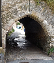
A well-restored brick and stone bridge crosses one of the streams of the River Colne. The stonework that lines the tops of the walls of the crossing have carved lettering that shows that the centre of the span was the boundary between Middlesex and Buckinghamshire and that the bridge was built in 1777. A large building with an archway that would have admitted stagecoaches at the eastern entrance to Colnbrook bears the name ‘White Hart House’. When Thorne was writing about the village in 1876, he noted that this was an inn:
“… a good house, with bowling green, and grounds, much in favour for trade dinners and pleasure parties…”
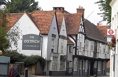
The George Inn, unlike the White Hart, is still in business. It is said that Princess Elizabeth, the future Queen Elizabeth I, might have spent a night there when being taken as a prisoner from Woodstock to Hampton Court in 1588. The pub was first established in the reign of Henry VIII. Its present façade is 18th century (www.sloughhistoryonline.org.uk). Other royal visitors to Colnbrook included the Black Prince with his prisoner King John of France, who were met here by King Edward III (reigned 1327-1377). The half-timbered Ostrich Inn, almost opposite the George, is far older and has a less salubrious history. Its foundations were laid in 1106 but much of its present construction is 16th century. Its name, the Ostrich, might well be a corruption of an earlier name, ‘the Hospice’.
During the 17th century, the Ostrich had an extremely dodgy landlord called Jarman. The pub’s website (https://ostrichcolnbrook.co.uk/history.html) describes his activities well. Here are some extracts from it. Jarman:
“…with his wife made a very profitable sideline by murdering their guests after they had retired for the night.
They had a trap door built into the floor of one of their bedrooms and when a suitably rich candidate arrived Jarman would inform his wife that a fat pig was available if she wanted one! She would reply by asking her husband to put him in the sty for till the morrow. The bedstead was hinged and they would tip the sleeping victim into a vat of boiling liquid immediately below, thus killing him.”
All went well for the Jarmans until they chose a clothier from Reading, named Thomas Cole:
“After persuading him to make his will before he retired, Jarman killed Cole. Unfortunately Cole’s horse was found wandering the streets nearby and caused a search for his owner who had been last seen entering The Ostrich! His body was found some time later in a nearby brook and some say that this Cole-in-the-brook is how Colnbrook got its name. It’s a nice story but whether it is true or not, who’s to say!”
You might be interested to learn that the Ostrich still offers rooms for guests to stay overnight. We met four men, who had done so, sitting quite contentedly in the morning sun that was flooding into the pub’s pleasant courtyard. Despite the story of Thomas Cole, it is far mor likely that the village was originally called ‘Colebroc’ (in 1107) and later ‘Colebrok’ (by 1222).
We visited the parish church of St Thomas just as guest were arriving at a christening. We were given a warm welcome by a female cleric dressed in white with a colourful stole, which she told us that she was wearing at such a happy occasion. The church, a Victorian gothic edifice, was designed by an architect who specialised in Gothic Revival, Benjamin Ferrey (1810-1880). Built between 1849 and 1852, it has walls containing flints. A north aisle, designed by a great practitioner of the Gothic Revival style, George Edmund Street (1824-1881), was added to the church in 1862.
Streams of the River Colne run through parts of the village. In some places their banks are lined with old houses, some half-timbered. Colnbrook, over which millions of people have flown since Heathrow was opened as Great west Aerodrome in 1929 and then as a much larger establishment, now known as London Heathrow, since 1946, is visited by few except mainly locals. Bypassed by major roads and not on the railway, the village has a picturesqueness that rivals many much more frequented places deep in the English countryside. Yet, Colnbrook is a short bus ride from Slough’s railway station and about 40 to 50 minutes’ drive from Hyde Park Corner. Visit the place and be surprised by its charm.
DOLLIS BROOK IS one of the two main tributaries of the River Brent, which in turn is a tributary of the River Thames, which it enters at Brentford. Dollis Brook rises near the A1 dual-carriageway at Mote End Farm and then flows southwards towards Brent Park, where it is joined by another stream, Mutton Brook. Both brooks are lined with pleasant green spaces containing footpaths that follow the streams. Thus, they are lovely green corridors providing much-needed rustic relief from the relentless built-up suburbia through which the streams flow.
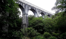
Nether Street is road running west and downhill from Finchley Central Underground Station. After reaching a small roundabout, it continues as Dollis Road. The latter descends ever more steeply until it runs under a tall brick arch, part of the Dollis Brook Viaduct (also known as ‘The Mill Hill Viaduct’). The road runs beside a stretch of Dollis Brook, which at that location is only a few feet in width – rather a miserable little stream. However, the viaduct with its 13 arches, each with spans of 32 feet, traverses a veritable steep sided gorge, maybe created over time by the waters flowing in the humble Dollis Brook, or, more likely, by glacial drift (“Nature”, 9th of November 1871: http://www.nature.com/articles/005027c0.pdf). This amazing viaduct, a masterpiece of brickwork, carries Underground trains on a spur of the Northern Line running between Finchley Central and Mill Hill East stations.
Designed by John Fowler (1817-1898) and Walter Marr Brydone, who was Engineer-in-Chief for the Great Northern Railway (‘GNR’) from 1855-1861, the viaduct was constructed between 1863 and 1867, when the first train ran across it. The line that now carries Northern Line trains over the viaduct was originally built by the GNR, as was the viaduct. As trains traverse the viaduct, they are at one point 60 feet above the ground. This point must be close to where both Dollis Road and Dollis Brook pass beneath the arches,
We have often driven beneath the viaduct, but it was only in August 2021 that we decided to park near it and examine it as closely as we could. We had recently visited the impressive granite railway viaduct near Luxulyan in deepest Cornwall and been amazed by its grandeur. We had not expected to find a bridge in north London that is almost as awe-inspiring. As I gazed upwards at its tall arches, I admired the Victorian bricklayers, who must have had to work at ever-increasingly dizzying heights as they constructed it. The viaduct is certainly a sight worth seeing, and whilst you are in the area, much pleasure can be gained by taking a stroll along the paths that run close to Dollis Brook.
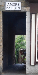
BRUTON IN SOMERSET lies along the River Brue. Most of the old town is high above the river on its steep banks. Narrow passageways run along the steep slopes, connecting the High Street with the riverbank below. These steep passageways in Bruton are called Bartons. The word ‘barton’ means ‘farmyard’ in Old English. However, why these passages are called ‘bartons’ in Burton is a bit of a mystery despite the fact that there used to be farmsteads close to the town.
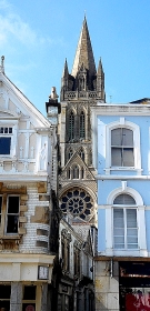
AN HOUR IN TRURO is hardly enough to get to know the county town of Cornwall well, but it is long enough to discover that the city’s centre is attractive and interesting. In 1876 the Diocese of Truro was founded and in the following year, it gained the status of ‘city’, making it the southernmost city in mainland Britain. Until the diocese was established, the county of Cornwall including the Scilly Isles and a couple of parishes in Devon were in the Diocese of Exeter. Given that the Christian faith was well established in this southwestern part of England at least 100 years before the first Archbishop of Canterbury was appointed, it was high time that Cornwall had its own diocese and archbishop.
Truro Cathedral
Between 1880 and 1910, a gothic revival cathedral designed by John Loughborough Pearson (1817-1897) was constructed on the site of the 15th century parish church of St Mary. Parts of this old church were incorporated into the new cathedral and the top of its granite spire stands in a garden next to it. One of only three British cathedrals with three spires, Truro’s cathedral was the first new cathedral to be built in England after many centuries. Although a relatively recent structure compared with many of Britain’s other cathedrals, it is a fitting design for the mediaeval heart of the city with its narrow winding streets.
The name Truro might be derived from the Cornish words meaning ‘three rivers’ or ‘the settlement on the River Uro’. In any case, Truro has a river running through it, which helped stimulate the growth of the city’s prosperity. During the 18th and 19th centuries, the tin mining industry added to Truro’s wealth. Lemon Street, where we parked, is evidence of that; it looks like a Georgian street in Bath or some parts of London. The arrival of a direct railway line between the city and London in the 1860s provided a further boost to the city’s success. Earlier in mediaeval towns, Truro, which is inland and therefore difficult to reach by seaborne foreign invaders, became an important port. In addition, it was a stannary town, where revenue from the tin industry was collected, yet another source of the town’s wealth.
Our brief first visit to Truro (at the end of a long day out) has whetted my appetite for another lengthier exploration of the city, which at first sight seems to have many interesting features to excite tourists who have an interest in history.
THE SMALL CORNISH village of Luxulyan has a fine old parish church, which is dedicated to Saints Ciricius and Julitta, both of whom are new to me. This edifice was built in the 15th century and restored in the 19th (https://historicengland.org.uk/listing/the-list/list-entry/1158407). The northern aisle of the church was filled with used books for sale when we visited it. A weathered Cornish cross stands close to the west end of the church. During the 19th century, this was brought to its present location from Three Stiles (near Consence). The church and its churchyard, along with the tiny village are charming, but what caught my eye and raised my curiosity was a building bearing the name ‘Captain TC Agar-Robartes Memorial.’
Treffry Viaduct near Luxulyan in Cornwall
The name Agar-Robartes intrigued me. My interest in it increased when I saw a small stone memorial near the River Fowey in Lostwithiel. It bore the words:
“Royal British Legion, Lostwithiel Branch, 1932-1997. Opened by Lady Robartes.”
Things became clearer after visiting the magnificent Lanhydrock House, originally constructed in the 17th century, and reconstructed quite faithfully after a huge fire in 1881. The house was created by John Robartes (1606-1685), 2nd Baron Robartes of Truro, 1st Viscount of Bodmin, and 1st Earl of Radnor. One of his many descendants, Anna Maria Hunt (1771-1861) married Charles Bagenal-Agar (1769-1811). One of their three sons, Thomas James Agar-Robartes (1808-1882), assumed the surname ‘Robartes’ in 1822 and tacked it on to his Agar surname. One of his ten grandchildren was Thomas Charles Reginald Agar-Robartes (1880-1915), the ‘TCR Agar-Robartes’, whose name is on the building in Luxulyan.
Thomas was educated at Eton and Christ Church College, Oxford. He was elected to represent the South-East Cornwall constituency as its MP in 1906. However, he was unseated a month after the election because of infringing some electoral regulations. He had been found guilty of bribery and other offences. Nevertheless, he was re-elected in 1908. His election campaign was based on support of free trade and reform of temperance laws. In August 1914, Thomas signed up as a 2nd Lieutenant in the Royal Bucks Hussars, and then in 1915, wanting to see action on the battlefront, he left for France as an officer in the 1st Battalion Coldstream Guards. In June 1915, he was promoted to become a captain. During the Battle of Loos in September 1915, he was shot in no-mans-land and never recovered.
The building, a working man’s institute and reading room in Luxulyan, which bears Thomas’s name, was first conceived in 1913, but only began to be used as such in 1924, when the edifice was completed. Naming it after Thomas is explained on a website page about the building (www.luxulyanpc.co.uk/Luxulyan_Memorial_Institute_32056.aspx): “ Tragically, as we know, young Tommy Robartes of Lanhydrock died after receiving wounds rescuing a comrade from one of those fields of battle. He had been well known and liked in the village, often coming to visit, accompanying the land agent dealing with tenants. The village picked up its interrupted thoughts on the Institute and Reading Room idea; whether the idea of a Memorial to Tommy, or just asking the Lanhydrock estate for a piece of land came first, is not clear, but it was agreed that a piece of land from the estate for a Memorial Institute was acceptable to all.”
Having already offered £50 towards building the Memorial institute, Dr Nathaniel T Coulson then offered a further £100 on condition that Thomas Agar-Robartes’s name was on the hall. Dr Coulson, who is described in the website, interested me because of his profession:
“He was born in Penzance in April 1853, abandoned by his drunken father at the age of 10 years and bound over to the farmer at Penquite Farm, Lostwithiel. He then spent some years in the British Navy and first arrived in San Francisco in 1875. For a while he worked for a stock-broking firm and wrote for several daily newspapers. In 1884 at the age of 30, he became a student at the dental department of the University of California, where he graduated after two years, receiving his degree as a Doctor of Dental Surgery. He was a member of several fraternal organisations, and generous with donations to many worthy causes. Among others in England, he helped finance the establishment of Coulson Park, Lostwithiel, in 1907. He travelled back here on several occasions, also visiting India after his retirement…”
So, that explains the hall that we saw in Luxulyan. I am not at all sure which ‘Lady Robartes’ is the one whose name appears on the British Legion monument in Lostwithiel, which bears the words “Opened by Lady Robartes”. If a Lady Robartes opened the branch in 1932, who was she? Only one of Thomas’s brothers married, Arthur (1887-1974). His wife, Patience Mary Basset, whom he married in 1920 might have been the ‘Lady Robartes’. Alternatively, she might have been one of Thomas’s sisters: Mary Vere (1879-1946) or Julia (1880-1969) or Edith (1888-1965) or Constance (1890-1936). If on the other hand the words refer to the inauguration of the monument in 1997, then I cannot offer any suggestions.
Luxulyan is worth visiting not only to see the things I have already mentioned, but also the impressive, massive, granite combined aqueduct and viaduct near to the village. It carries water and a railway track over the River Par. Known as the Treffry Viaduct, it was completed in 1844 and designed by the engineer and mining entrepreneur Joseph Treffry (1782-1850).
Until we visited Luxulyan, I had never heard of the Agar-Robartes family. Once again, visiting Cornwall has resulted in finding places and persons of great interest. The more I see, the more I want to know.
MY COUSINS IN CORNWALL live not far from a place called Withiel. The mainline train from London to Penzance usually stops at a station called Lostwithiel. The latter is just over 7 miles southeast of Withiel as the crow flies. Yesterday, the 26th of July 2021, we decided to visit both Withiel and Lostwithiel. Despite its name, Lostwithiel on the River Fowey is much easier to access than Withiel, which is deep in the Cornish countryside.
Mediaeval arch in Lostwithiel
The ‘lost’ in Lostwithiel has little if anything to do with being unable to be found. There is agreement that ‘lost’ is the Cornish word for ‘tail’. It is likely that Lostwithiel derived from the Cornish ‘Lost Gwydhyel’, meaning ‘tail end of woodland’. The village of Withiel is known as ‘Egloswydhyel’ in the Cornish language. This means ‘church in woodland’. Having found out that Lostwithiel is not actually lost nor ever has been, I will compare the two places.
Withiel, far smaller than Lostwithiel, is small village with a fine old church, St Clements and a few, about twenty at most, houses arranged around a rectangular open space. The parish church, which I have yet to enter, originated in the 13th century. It was rebuilt in granite in the 15th and 16th centuries and looks far too large for such a small village and its neighbouring communities including one called Withielgoose. The rebuilding was instigated by Thomas Vyvyan (late 1470s – 1533), the penultimate Prior of Bodmin before the Reformation. He was a Cornishman educated at Exeter College (Oxford), who was instituted in the rectory of Withiel in 1523, and then at St Endellion Church in 1524. Withielgoose, which is tiny place that includes the word ‘withiel’, has nothing to do with geese. The name derives from the Cornish words ‘gwyth’, meaning trees; ‘yel’, of unknown meaning; and ‘coes’, meaning ‘wood’.
Tiny Withiel has at least one interesting historical figure apart from Thomas Vyvyan, Sir Bevile Grenville (1594/95-1643). Educated at Exeter College (Oxford), he was a Member of Parliament and a Royalist. He was killed at The Battle of Lansdown (5th of July 1643) in the English Civil War. The historian of the Civil War Edward Hyde, 1st Earl of Clarendon (1609-1674), who served the Royalists during the conflict, wrote of Sir Bevile:
“…to the universal grief of the army, and, indeed, of all who knew him. He was a gallant and a sprightly gentleman, of the greatest reputation and interest in Cornwall, and had most contributed to all the service that had been done there.”
From small Withiel, we move to the town of Lostwithiel, an attractive place that seems not to have become as great a tourist attraction as have many other picturesque places in Cornwall. The town was established in the early 12th century by Norman lords, who constructed Restormel Castle nearby. It was a stannary town, which meant that it could manage the collection of ‘tin coinage’, a duty payable on tin mined in Cornwall. Most of what was collected entered the coffers of the Duchy of Cornwall.
In the 13th century, Edmund, 2nd Earl of Cornwall (‘Edmund of Almain’; 1249-1300) built both the Great Hall in Lostwithiel and the town’s church tower. Edmund was son of Richard of Cornwall, 1st Earl of Cornwall and King of the Romans (king, not emperor, of the Holy Roman Empire) between 1257 and 1272. The tower is still standing as are also the remains of the Great Hall, built between about 1265 and 1300, making it one of the oldest non-ecclesiastical buildings in Cornwall. It was a large complex of buildings, which was badly damaged during the English Civil War. What remains is an interesting set of mediaeval buildings and the old Exchequer Hall, now known as ‘The Duchy Palace’. Later used as a Masonic Hall, some of its windows contain six-pointed stars as used by the Masons. A crest on one of its walls is the earliest version of that of the Duchy of Cornwall, which has long since been replaced by the plume of feathers used today. The Cornish born (in St Austell) and world-renowned historian Alfred Leslie Rowse (1903-1997) wrote that in the mediaeval era:
“… the real centre of Duchy administration was Lostwithiel; here the various offices, the shire hall where the county court met, the exchequer of the Duchy, the Coinage Hall for the stannaries’ and the stannary jail, were housed in the fine range of buildings built by Edmund, Earl of Cornwall…”
So, Lostwithiel was once important as an administrative centre, but it has now lost this role.
The River Fowey flows through Lostwithiel, passing meadows where people picnic, and children play. The river, though wide, is shallow enough for youngsters to play in safely. The river is crossed by a magnificent multi-arched, stone bridge, which is so narrow that it is only wide enough for one single motor vehicle. The crossing has six pointed arches. It was constructed in the mid-15th century. Its parapets were built in the 16th century and an additional flood arch was added in the 18th century (https://historicengland.org.uk/listing/the-list/list-entry/1327324).
We wandered around Lostwithiel for a while and saw many fine old buildings apart from those already mentioned. One of them is the Museum, housed in the former Corn Exchange (a Georgian building), and the former Grammar School. We also spotted an ancient Cornish cross in the parish churchyard. Lostwithiel is a place to which I hope to return to spend more time there. In comparison to Withiel that is far more lost from sight, Lostwithiel has plenty to interest the visitor.
THE CONSERVATIVE CLUB in Cornwall’s Wadebridge has opened its doors to the general public. Visitors to the club of any political persuasion can enjoy superbly cooked food in its bar and dining room, which bears the name ‘Winstons’. The club, which is located at the higher end of Molesworth Street, is housed in a building that is far more than 100 years old. The street runs gently downhill towards a multi-arched stone bridge that crosses the River Camel.
Before there was a bridge across the river, the town now known as Wadebridge was called ‘Wade’ and stood beside a ford across the Camel, whose name probably means ‘crooked one’. Crossing the river by means of the ford was perilous. Before the bridge was built, a ferry became available as an additional means of traversing the wide stream. Becoming distressed by the number of people and animals that died whilst attempting to cross the river, the Reverend Thomas Lovibond, Vicar of Egloshayle, had the idea of building a bridge. This bridge was constructed between 1468 and 1485. It is said that its supporting piers rested on packs of wool. With the arrival of the bridge, the town of Wade became renamed ‘Wadebridge’. The chronicler and topographer William of Worcester (1415-c1482) mentioned the bridge as ‘Wade-brygge’ in 1478’.
The bridge was widened in 1853 and again in 1963. It was refurbished in 1994. Although the stonework of the arches looks old, I am not sure how much of it is part of what was constructed in the late 15th century.
During the Civil War (1642-1651), Cornwall was a Royalist stronghold. Much of the rest of the southwest of England supported the Royalist’s opponents, the Parliamentarians. Wadebridge’s bridge was an important strategic location. In 1646, the Parliamentarian Oliver Cromwell (1599-1658) led 500 dragoons and 1000 horsemen successfully to take control of the bridge. The story goes as follows (www.cornwalllive.com/news/history/oliver-cromwell-came-person-take-511634):
“After losing the decisive Battle of Torrington in Devon on February 16, 1646, the Royalists escaped into Cornwall … [the] Parliamentarians, led by Thomas Fairfax, hunted them down and reached Launceston on February 25 and Bodmin on March 2 … On March 5 the Cornish Royalist leaders realised they were fighting a losing battle and surrendered the east of Cornwall to the Parliamentarians at Millbrook … A day later, as the battle moved westwards, Parliamentarian commander Oliver Cromwell and 1,500 of his soldiers descended onto Wadebridge to take control of the bridge and prevent its use by the Royalist army. The route across the bridge was considered to be of such strategic importance that Cromwell, who had been spending months mopping up resistance in Devon and Cornwall, personally led his troops there to capture it.”
The huge forces brought by Cromwell were either unnecessary or an effective deterrent because the Royalists withdrew without putting up a fight (www.wadebridgemuseum.co.uk/bridge.html).
The first motor car to cross the bridge did so in 1901. The crossing continues to play an important role in the transport network of Cornwall. The town is a charming small centre, well supplied with pubs, independent shops, and branches of supermarket chains. It is a part of the Parliamentary constituency of North Cornwall. Diners at, and members of, Wadebridge Conservative Club might (or might not) be pleased to know that the local MP since 2015 is Scott Mann, a Conservative. He was born in Wadebridge and attended its local state secondary school. I suppose that he must have dined or drunk at the Conservative Club where we enjoyed first class food. So, next time you are in Wadebridge, sweep aside any political prejudices you might harbour and head for Winstons at the Conservative Club and enjoy a great meal.
DESPITE THE RAIN, we decided to walk along the path by the River Thames, proceeding upstream from Hammersmith. I had done this before, but never ventured beyond (i.e., upstream) the attractive church of St Nicholas, Chiswick, in whose graveyard you can find the funerary monument to the painter, William Hogarth (1697-1764), whose former home is nearby, and another to the Italian patriot, Ugo Foscolo (1778-1827). After walking along a riverside pathway that passes several recent, moderately attractive, but probably immoderately priced, housing estates, we reached Chiswick Pier at Corney Reach, whose name commemorates the now demolished Corney House, where Queen Elizabeth I was once entertained by the Earl of Bedford, who owned the place (www.chiswickw4.com/default.asp?section=info&page=conhistory29.htm).
Several lovely old houseboats are moored next to the pier. Near the jetty there is a noticeboard explaining the history of each of these vessels. Soon after this, the riverside path enters Dukes Meadow. Up to Barnes Bridge, which is a combined rail and pedestrian crossing over the river, the meadows form a grassy promenade running parallel to the Thames. Beyond the bridge, the meadows widen out and extend to Great Chertsey Road that crosses Chiswick Bridge.
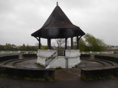
The bandstand at Dukes Meadow
The history of Dukes Meadow is recorded in a detailed essay by Gillian Clegg (https://brentfordandchiswicklhs.org.uk/dukes-meadows-the-threats-to-its-rural-survival/), from which I have extracted most of the following. In the past, the Meadow were low lying farmland and orchards prone to occasional flooding. The land was owned by the Dukes of Devonshire and cultivated by the Jessop family, then later farmed by John Smith of Grove Farm. Incidentally, one of the Dukes, William, the 5th Duke of Devonshire (1748-1811), who had owned nearby Chiswick House in the 18th century. He had both enlarged the house (in 1788) and extended its grounds. At one time, the grounds of Chiswick House must have neighboured the Dukes Meadow. Ms Clegg noted that it was miraculous that the meadows survived as such considering the plans that were proposed for making use of it during the early 20th century.
Two plans were conceived for the ‘development’ of Dukes Meadow. The first was a housing scheme that was to be named ‘Burlingwick’. Clegg wrote:
“On 19 April 1902 The Times newspaper reported that ‘an influential body of capitalists’ had negotiated successfully with the Duke of Devonshire for 330 acres of land for a building plan to be called Burlingwick. The promoter, manager and developer of this scheme was Jonathan Carr, the developer of Bedford Park.”
Had this gone ahead, it would have created housing for up to 400,000 people and 330 acres of green land would have been lost to bricks and mortar. Fortunately, for reasons that are not now too clear the scheme was abandoned in about 1906.
1914 saw the next threat to the Meadows. The Brentford Gas Company planned to cover 80 acres of the Meadow with a huge gasworks. The people of Chiswick and other areas raised strong objections. The London “Times” of 6th February 1914 published its doubts about the scheme, which it said went against all the principles of good town planning, suggesting:
“…that land ripe for building – such as the Chiswick orchard farm – near the heart of the metropolis should be utilized for parks and garden settlement.”
The plan was scrapped, but what the “Times” had alluded to was later realised, but in a then novel way.
In 1923, the local council bought 200 acres of land from the then Duke of Devonshire. The land was to be used as a public recreation area complete with a riverside promenade, a bandstand, and a children’s area with paddling pools. All of this cost the council much money. To recoup some of what they had spent, they made an agreement with the Riverside Sand and Ballast Group. As Ms Clegg explained, the company:
“…was allowed to extract at least five acres every year in exchange for £1,500 an acre.”
The extraction of gravel proceeded from 1924 until 1937 and caused considerable damage to the area. Ms Clegg explained that when the land was finally returned to the council in 1948:
“The gravel pits were filled in, mainly with rubbish brought from inner London, and the area re-landscaped. Dukes Meadows has been described as one of the earliest and most impressive examples of restoration.”
Today, the promenade remains but I saw neither a children’s play area nor paddling pools, which still exist. The bandstand, which stands within a sunken circle lined with steps on which the audience can sit has a hexagonal tiled roof supported by six plain pillars. It is flanked on two sides by spacious shelters, also with tiled roofs. All their roofs are designed so that the angle (or degree) of pitch reduces noticeably about two thirds of the way from the top. Judging by their appearance, I would guess that these structures were built back in the early 1920s. This is confirmed by their appearance in a photograph taken during those years. Also visible in this picture are the unusual, twisted railings, looking like sugar-candy, running alongside the water, and supported by concrete posts with rounded tops. These are still in place today as are their concrete supports which bear simple decorative patterns. Some balustrading can be seen lining the waterfront near the bandstand (see quote below).
Part of the promenade leading towards Barnes Bridge from the Chiswick end of the Meadow is arranged in the form of two long steps. I have no idea why, but maybe they were once used by spectators watching boat races on the river. An article written in 1924 describes the popularity the Meadow with people watching the annual university boat race (http://dmtrust.dukesmeadowspark.com/newriversidepleasaunce.html):
“…in fact so many thousands of people availed themselves of this vantage point last Saturday week at the small admission fee charged by the Council, that over £1,000 net was raised towards the promenade project.”
However, currently a line of bushes obscures sight of the river and the suburb of Barnes across it from these steps. A planning document produced in November 1923 (http://dmtrust.dukesmeadowspark.com/ariversideboulevard.html) sheds a little light on these steps:
“The Scheme, which received the first prize and was submitted by MR A. V. Elliot, of Chiswick, is reproduced on this page. It shows a series of terraces with a plateau of turf, showing seats and rustic shrubberies at intervals, and with a central feature of a bandstand and stone balustrading including a flight of steps and a causeway admitting to the river at all states of the tide.”
We enjoyed our stroll along the Dukes Meadow promenade even though the sky was grey, trees were dripping, and raindrops were falling intermittently. On our way back along the Thames Path to Hammersmith, we stopped at a charming Italian eatery and delicatessen on Chiswick Mall. The place, which is run by Sicilians, is called Mari Deli & Dining, and merits a visit to enjoy a good espresso, at the very least.
JUST UNDER A YEAR AGO, we visited Cookham in Berkshire, a small town on the River Thames, with our friend ‘H’. I first met H and her widowed mother in about 1975 at the home of some dear friends, my PhD supervisor and his wife. My wife and I used to see H about once a year until about 1999 at the home of our mutual friends. Then, we lost touch. A few years ago, H and I reconnected via social media and we kept promising that we should meet up again. It was only in about July 2020 during a relaxation of the covid19 regulations that we finally met face to face. Our meeting was in Cookham, where we enjoyed an exhibition at the small Stanley Spencer Art Gallery. After having coffee together – it was the first time that H had been to drink coffee outside her home since mid-March, we walked through the rain to Cookham Bridge and crossed it, admiring the lovely views of the Thames.
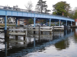
Cookham Bridge
The roadway on Cookham Bridge is so narrow that traffic must be regulated by signals at both ends of the crossing. These signals allow traffic to flow in single file in one direction for a few minutes, and then in the other. While we walked across the bridge, I noted its lovely decorative iron railings, which can be seen in a painting, “Swan Upping at Cookham” (www.tate.org.uk/art/artworks/spencer-swan-upping-at-cookham-t00525), painted in 1915-19 by Cookham’s famous artist Stanley Spencer (1891-1959).
It was not until April 2021 that we revisited Cookham with some friends and walked along the Thames Path, which passes under Cookham Bridge. It was then that I noticed what we had not seen with H: the interesting Victorian ironwork structure supporting the crossing. A sign screwed onto one of the pontic’s metal panels reads: “Pease, Hutchinson, & Co. 1867. Engineers & iron Manufacturers. Skerne Iron Works. Darlington”. The Skerne Iron Works were:
“…run by a Quaker partnership trading as Pease, Hutchinson and Ledward. The Skerne company built its reputation upon plates for ships, boilers, and particularly bridge building, and at its peak employed 1,000 workers.” (www.gracesguide.co.uk/Pease,_Hutchinson_and_Co)
The iron bridge, supported by pairs of slender iron beams (filled with concrete) with cross-bracing rods, was opened in 1867 to replace an earlier wooden bridge that was opened in 1840. The existing bridge was when it was constructed the cheapest bridge across the Thames for its size (https://en.wikipedia.org/wiki/Cookham_Bridge). Until 1947, it was a privately owned bridge for which users needed to pay a toll. It was owned by the Cookham Bridge Company. In 1947, Berkshire County Council bought the bridge, and the toll was abolished. An octagonal house still stands next to the bridge across the river from Cookham. It is the early 19th century toll house built in 1839 by a Mr Freebody (https://heritageportal.buckinghamshire.gov.uk/Monument/MBC19500).
At the Cookham side of the bridge stands The Ferry pub, close to where there used to be a ferry across the river. This old, half-timbered inn, now a mid-priced eatery, has a lovely terrace by the river, from which the bridge can be viewed as well as the waterways leading downstream to Cookham weir and the lock that bypasses it.
Recently, a close relative of H contacted me. He had found my details in the address book in H’s computer. It came as a shock to learn from him that H had passed away suddenly a few weeks ago. When we had last seen her late last year, she was looking hale and hearty. Apparently, one Saturday, she began feeling extremely unwell and on the following day she expired. We were terribly upset because we got on so well with her and were planning outings with her once the covid19 socialising restrictions were eased. They were relaxed but not in time for us to be able to see H again. As we drove through Cookham on our most recent visit, we kept seeing places that reminded us of our meeting with her last summer.
Our friend with whom we crossed Cookham Bridge last year has crossed from this world into another, where I hope that she will be reunited with her parents, our mutual friends, who introduced her to me and then later to my wife, as well as Sir Geoffrey Howe and Elspeth, his wife, with whom she worked happily for many years. H will be sorely missed.