THE HUMBLE BRICK is a much used material in the construction of many kinds of building. It can be used unimaginatively, as it often is, or imaginatively to create visually intriguing textures.
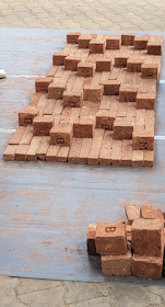
During a visit to one of Bangalore’s art schools, the Chitrakala Parishath, we watched architecture students participating in an outdoor “brick techtonics” workshop. This was being supervised by the noted Indonesian architect Andy Rahman.
We watched small groups of students arranging bricks so as to make interesting patterns, following plans drawn up by Andy Rahman. As they worked, Mr Rahman moved from group to group, discussing with them what they were doing.
All around the area where the workshop was taking place, labourers were working noisily on a construction site where new buildings were being built for the art school. Thus, the architects working on realising theoretical bricklaying design ideas were surrounded by real life applications of established building practices.
I hope that when the budding architecture students begin designing ‘for real’ that they will recall the interesting brickwork creativity that Mr Rahman was introducing to them. For he was showing them that even the humble brick can become a component in a visually fascinating design.
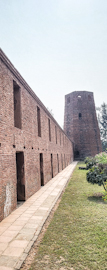
THE COUNTRYSIDE AROUND Murshidabad is dotted with brick factories. Their tall, often smoking, chimneys are surrounded by vast expanses of new bricks, usually stacked neatly. The clay that can be found in the area is particularly good for brick making. So, it is unsurprising that many local buildings make substantial use of brickwork.
One of the towers of the Katra mosque
Near Murshidabad, there are two famous mosques constructed not with stone or concrete, but with bricks. One of these, the Katra mosque, was constructed entirely with bricks between 1723 and 1724. This huge edifice was built not only as a mosque but also as a caravanserai. It is one of the largest caravanserais in the Indian Subcontinent. The rooms of the caravanserai are arranged in a square that surrounds the mosque rather like cloisters in a monastery. These small rooms also served as workplaces and bedrooms for students studying the Koran and other Islamic texts. Thus, the Katra was a complex consisting of a mosque, a caravanserai, and a madrasa. At each of its four corners, there were tall brick towers. Only two of these remain. The tomb of Nawab Murshid Quli Khan(1660-1727) is located under the staircase leading to the main entrance of the building. Protected by the Archaeological Survey of India, the remains of the Katra complex are well conserved. This is not the case for another brick mosque nearby: the Fauti Masjid.
The Fauti was constructed in 1740 by Nawab Safaraz Khan (c1700 – 1740). However, it was never completed. It is a large mosque, 137 feet long and 38 feet wide. If you manage to chamber within it, which I did with great difficulty despite helping hands, the remains of its five huge incomplete domes can be seen.
The Fauti is a protected building, but in a bad condition. It is possibly perilously unstable. However, because of the vegetation around it and within it, it is a picturesque ruin of the sort that eighteenth and nineteenth century European Romantic artists enjoyed portraying.
In addition to these mosques, which were built using baked clay (I.e., bricks), we have also seen some Hindu temples near Murshidabad that include terracotta in their construction. But more about these at a later date.
THE DAVID LEAN cinema, where we watched a superb film called “Coming to America” (made in 1988), is within a complex known as the Croydon Clocktower. In the heart of Croydon, this cultural centre is housed in what was originally constructed as the district’s Town Hall.
The Town Hall is a magnificent – exuberant – example of Victorian brickwork. It was constructed to the designs of a local architect, Charles Henman, and inaugurated by the Prince of Wales in 1896. There is a large statue of his mother, Queen Victoria, outside the façade on Katherine Street.
Until the 1980s, the enormous edifice was used for local government purposes. In the late 1980s, and early 1990s, the interior was renovated. Areas that were no longer needed for council business were repurposed as a public library, a café, a museum, and the David Lean cinema. A large room, which retains its original interior décor, the Braithwaite Hall, continues to be used for concerts, theatrical shows, and other public functions. It looked to me that the inside of the building had been hollowed out to create a spacious central atrium with a glass roof, which can be overlooked from galleries surrounding it on each floor. The result is pleasing to the eye. From the outside of the building, you would not expect to see this kind of atrium. The Town Hall complex is now known as the Croydon Clocktower, the name referring to the building’s high brick clock tower.
The film we watched in the small David Lean cinema was wacky but wonderful – a complete contrast to an incredibly slow-moving Taiwanese film, “Days”, which we watched a few days later.
UNTIL RECENTLY, LONDON Bridge railway station, overshadowed by the glass-clad Shard skyscraper, was not visually appealing. It was a place that you lingered no longer than necessary either whilst waiting for a train or having just disembarked.
Today, the station has been transformed into a place where you might want to linger and explore. It has been cleaned up and tastefully remodelled. The station and the tracks leading from it have always been above ground, supported by innumerable brickwork arches. A few years ago before the improvement works were carried out, many of these archways led to passages beneath the station, most of them dark and unwelcoming.
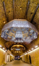
One of these was the Stainer Street Walkway that links St Thomas Street and Tooley Street and passes through the station’s foyer from which stairways lead up to platforms. This wide passageway lined with ochre coloured brickwork is now well-lit and apart from being a bit chilly, quite pleasant. But look up, and you will see three enormous, reflective, decorative umbrellas suspended from the ceiling. Each umbrella is decorated with geometric symbols and lettering. The lettering forms sets of words that are supposed to be meaningful for those who bother to read them.
Together, these umbrellas comprise an artwork, “.Me. Here. Now” by Mark Titchner , which were put in place in mid-2019. With the decrease in passenger numbers since the start of the covid19 pandemic, this lovely set of artefacts have been seen by far fewer people than were anticipated by the commissioners of this creation, Network Rail.
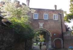
WE VISIT RICHMOND regularly to see a couple of friends, with whom we almost always take a stroll, usually somewhere reasonably near their home. They know that I love seeing places that I have never visited before and almost always they take us to see something that they feel might interest us. On our most recent walk with them, taken in October 2021, we began by walking across Richmond Green, taking a path that was new to us. At the western edge of the green, we crossed a road and immediately reached a Tudor gateway that leads into an open space surrounded by buildings. The open space is on the site of a now mostly demolished royal residence that was particularly liked by Queen Elizabeth I.
The royal residence was Richmond Palace. It was built by King Henry VII, when the 14th century Shene Palace, which used to stand on the site, was destroyed by fire in December 1497. Henry VII built a new palace on the same ground plan of Shene Palace. Richmond Palace, as the new building was named, was used continuously a royal residence until the execution of King Charles I in January 1649.
On a wall facing a pathway leading from the old gatehouse to the River Thames, there is a commemorative plaque with the following carved on it:
“On this site extending eastwards to cloisters of the ancient friary of Shene formerly stood the river frontage of the Royal Palace first occupied by Henry I in 1125…”
It adds that Edward III, Henry VII, and Elizabeth I all died in the palaces that stood on this riverside site in Richmond.
After Charles I lost his head, the palace, like many other parts of the royal estate, was sold by the Commonwealth Parliament led by Oliver Cromwell. Much of its masonry was sold. According to an informative source (www.richmond.gov.uk/media/6334/local_history_richmond_palace.pdf):
“While the brick buildings of the outer ranges survived, the stone buildings of the Chapel, Hall and Privy Lodgings were demolished and the stones sold off. By the restoration of Charles II in 1660, only the brick buildings and the Middle Gate were left.”
The same source relates that after being owned by the Duke of York, who became King James II, and after he was deposed:
“The remains of the palace were leased out to various people and, in the early years of the 18th century new houses replaced many of the crumbling brick buildings. ‘Tudor Place’ had been built in the open tennis court as early as the 1650s, but now ‘Trumpeters’ House’ was built in 1702-3 to replace the Middle Gate, followed by ‘Old Court House’ and ‘Wentworth House’ (originally a matching pair) in 1705-7. The Wardrobe building had been joined up to the Gate House in 1688-9 and its garden front was rebuilt about 1710. The front facing the court still shows Tudor brickwork as does the Gate House. ‘Maids of Honour Row’ replaced most of the range of buildings facing the Green in 1724-5 and most of the house now called ‘Old Palace’ was rebuilt about 1740.”
During our recent perambulation with our friends, we saw most of the buildings listed in the quote above but not the Maids of Honour Row. They also pointed out that Richmond Green, across which we walked, was used for jousting tournaments in mediaeval times. Today, this pleasant green space close to Richmond’s main shopping street is used for more peaceful purposes including walking, both human beings and their canine companions.
Once again, a visit to our friends in Richmond has resulted in opening our eyes to new places of great interest, and for that we are most grateful.
DOLLIS BROOK IS one of the two main tributaries of the River Brent, which in turn is a tributary of the River Thames, which it enters at Brentford. Dollis Brook rises near the A1 dual-carriageway at Mote End Farm and then flows southwards towards Brent Park, where it is joined by another stream, Mutton Brook. Both brooks are lined with pleasant green spaces containing footpaths that follow the streams. Thus, they are lovely green corridors providing much-needed rustic relief from the relentless built-up suburbia through which the streams flow.
Nether Street is road running west and downhill from Finchley Central Underground Station. After reaching a small roundabout, it continues as Dollis Road. The latter descends ever more steeply until it runs under a tall brick arch, part of the Dollis Brook Viaduct (also known as ‘The Mill Hill Viaduct’). The road runs beside a stretch of Dollis Brook, which at that location is only a few feet in width – rather a miserable little stream. However, the viaduct with its 13 arches, each with spans of 32 feet, traverses a veritable steep sided gorge, maybe created over time by the waters flowing in the humble Dollis Brook, or, more likely, by glacial drift (“Nature”, 9th of November 1871: http://www.nature.com/articles/005027c0.pdf). This amazing viaduct, a masterpiece of brickwork, carries Underground trains on a spur of the Northern Line running between Finchley Central and Mill Hill East stations.
Designed by John Fowler (1817-1898) and Walter Marr Brydone, who was Engineer-in-Chief for the Great Northern Railway (‘GNR’) from 1855-1861, the viaduct was constructed between 1863 and 1867, when the first train ran across it. The line that now carries Northern Line trains over the viaduct was originally built by the GNR, as was the viaduct. As trains traverse the viaduct, they are at one point 60 feet above the ground. This point must be close to where both Dollis Road and Dollis Brook pass beneath the arches,
We have often driven beneath the viaduct, but it was only in August 2021 that we decided to park near it and examine it as closely as we could. We had recently visited the impressive granite railway viaduct near Luxulyan in deepest Cornwall and been amazed by its grandeur. We had not expected to find a bridge in north London that is almost as awe-inspiring. As I gazed upwards at its tall arches, I admired the Victorian bricklayers, who must have had to work at ever-increasingly dizzying heights as they constructed it. The viaduct is certainly a sight worth seeing, and whilst you are in the area, much pleasure can be gained by taking a stroll along the paths that run close to Dollis Brook.