
If you are lost
Somewhere deep in the countryside
Look for a signpost

If you are lost
Somewhere deep in the countryside
Look for a signpost
MY COUSINS IN CORNWALL live not far from a place called Withiel. The mainline train from London to Penzance usually stops at a station called Lostwithiel. The latter is just over 7 miles southeast of Withiel as the crow flies. Yesterday, the 26th of July 2021, we decided to visit both Withiel and Lostwithiel. Despite its name, Lostwithiel on the River Fowey is much easier to access than Withiel, which is deep in the Cornish countryside.
The ‘lost’ in Lostwithiel has little if anything to do with being unable to be found. There is agreement that ‘lost’ is the Cornish word for ‘tail’. It is likely that Lostwithiel derived from the Cornish ‘Lost Gwydhyel’, meaning ‘tail end of woodland’. The village of Withiel is known as ‘Egloswydhyel’ in the Cornish language. This means ‘church in woodland’. Having found out that Lostwithiel is not actually lost nor ever has been, I will compare the two places.
Withiel, far smaller than Lostwithiel, is small village with a fine old church, St Clements and a few, about twenty at most, houses arranged around a rectangular open space. The parish church, which I have yet to enter, originated in the 13th century. It was rebuilt in granite in the 15th and 16th centuries and looks far too large for such a small village and its neighbouring communities including one called Withielgoose. The rebuilding was instigated by Thomas Vyvyan (late 1470s – 1533), the penultimate Prior of Bodmin before the Reformation. He was a Cornishman educated at Exeter College (Oxford), who was instituted in the rectory of Withiel in 1523, and then at St Endellion Church in 1524. Withielgoose, which is tiny place that includes the word ‘withiel’, has nothing to do with geese. The name derives from the Cornish words ‘gwyth’, meaning trees; ‘yel’, of unknown meaning; and ‘coes’, meaning ‘wood’.
Tiny Withiel has at least one interesting historical figure apart from Thomas Vyvyan, Sir Bevile Grenville (1594/95-1643). Educated at Exeter College (Oxford), he was a Member of Parliament and a Royalist. He was killed at The Battle of Lansdown (5th of July 1643) in the English Civil War. The historian of the Civil War Edward Hyde, 1st Earl of Clarendon (1609-1674), who served the Royalists during the conflict, wrote of Sir Bevile:
“…to the universal grief of the army, and, indeed, of all who knew him. He was a gallant and a sprightly gentleman, of the greatest reputation and interest in Cornwall, and had most contributed to all the service that had been done there.”
From small Withiel, we move to the town of Lostwithiel, an attractive place that seems not to have become as great a tourist attraction as have many other picturesque places in Cornwall. The town was established in the early 12th century by Norman lords, who constructed Restormel Castle nearby. It was a stannary town, which meant that it could manage the collection of ‘tin coinage’, a duty payable on tin mined in Cornwall. Most of what was collected entered the coffers of the Duchy of Cornwall.
In the 13th century, Edmund, 2nd Earl of Cornwall (‘Edmund of Almain’; 1249-1300) built both the Great Hall in Lostwithiel and the town’s church tower. Edmund was son of Richard of Cornwall, 1st Earl of Cornwall and King of the Romans (king, not emperor, of the Holy Roman Empire) between 1257 and 1272. The tower is still standing as are also the remains of the Great Hall, built between about 1265 and 1300, making it one of the oldest non-ecclesiastical buildings in Cornwall. It was a large complex of buildings, which was badly damaged during the English Civil War. What remains is an interesting set of mediaeval buildings and the old Exchequer Hall, now known as ‘The Duchy Palace’. Later used as a Masonic Hall, some of its windows contain six-pointed stars as used by the Masons. A crest on one of its walls is the earliest version of that of the Duchy of Cornwall, which has long since been replaced by the plume of feathers used today. The Cornish born (in St Austell) and world-renowned historian Alfred Leslie Rowse (1903-1997) wrote that in the mediaeval era:
“… the real centre of Duchy administration was Lostwithiel; here the various offices, the shire hall where the county court met, the exchequer of the Duchy, the Coinage Hall for the stannaries’ and the stannary jail, were housed in the fine range of buildings built by Edmund, Earl of Cornwall…”
So, Lostwithiel was once important as an administrative centre, but it has now lost this role.
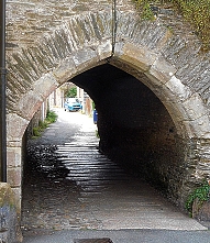
The River Fowey flows through Lostwithiel, passing meadows where people picnic, and children play. The river, though wide, is shallow enough for youngsters to play in safely. The river is crossed by a magnificent multi-arched, stone bridge, which is so narrow that it is only wide enough for one single motor vehicle. The crossing has six pointed arches. It was constructed in the mid-15th century. Its parapets were built in the 16th century and an additional flood arch was added in the 18th century (https://historicengland.org.uk/listing/the-list/list-entry/1327324).
We wandered around Lostwithiel for a while and saw many fine old buildings apart from those already mentioned. One of them is the Museum, housed in the former Corn Exchange (a Georgian building), and the former Grammar School. We also spotted an ancient Cornish cross in the parish churchyard. Lostwithiel is a place to which I hope to return to spend more time there. In comparison to Withiel that is far more lost from sight, Lostwithiel has plenty to interest the visitor.
SINCE THE IMPOSITION OF ‘LOCKDOWN’ in the UK, use of public transport has been discouraged, as has wandering too far from home when taking exercise. While not exactly ‘confined to barracks’, the distance that we have been allowed to move away from home has been limited, more or less to the amount of distance that we can manage to walk (or, not in my case, cycle) comfortably, without exhausting ourselves. This meant that for many weeks we have been walking around our local area. A friend of ours in Dublin told us, half-jokingly, that during the Irish lockdown, he felt that he had got to know every blade of grass in his neighbourhood. I understood what he was saying. For me, greater familiarity with our immediate locality has not bred contempt for it, but the opposite. We have been walking along small streets we never knew existed and discovering interesting details in those thoroughfares that we thought we knew so well.

I have been walking along Sheffield Terrace, which leads off Kensington Church Street, two or three times a week for the last 25 years, yet it was only yesterday that I noticed a small square metal plate on the wall of a house in that thoroughfare. It recorded the fact that the author GK Chesterton was born in that house on the 29th of May 1874. A few doors away on the same street, there is a much larger and far more obvious plaque commemorating that the founder of the Church Army, Prebendary Wilson Carlile (1847-1942) had lived there. I had often noticed this memorial, but I had never noticed the far more discreet memorial to Chesterton, which looks like a simple grey wall tile from a distance.
Sheffield Terrace leads to the northern end of Hornton Street, which is marked on 19th century Ordnance Survey maps as ‘Campden House Road’. Hornton Street leads south and downhill towards High Street Kensington. Once again, this is a street along which I have walked several times a week over a period of at least 25 years. Various roads lead off Hornton Street. The short Pitt Street is one of these. On the corner of Pitt and Hornton Streets, there is a faded rectangular sign that I have always assumed carried the words ‘Hornton Street’. However, I had not looked at it closely enough until yesterday.
I do not know what made me examine the faded sign closely, but I am glad that I did. Some of the letters on it have disappeared. The following are just about visible, and even more so on enhanced digital photographs: H, O, R, N, …, D, G, E. The last three letters are not ‘E, E, T’, which you would expect to see if the sign had read ‘Hornton Street’. I wondered if the sign had originally read ‘Hornton Lodge’. I went home and searched for ‘“Hornton Lodge” Kensington’ on Google.
One of the most useful things that came up amongst the Google search results was an offer on eBay for two pages of the issue of “Country Life” magazine, dated 21st of March 1968. These pages contain an article about Hornton Lodge on Pitt Street. The article bore the title “Serene Vision of a Modern Interior”. It describes the interior of a house built in 1948 on a bomb site and owned by Mr and Mrs James Melvin. The house, a long rectangular building, was called Hornton Lodge. The fading sign is all that remains of the house described in the magazine. Currently, builders are erecting a new building on the part of the plot nearest to the corner where the sign can be found. This new construction is, according to a planning application submitted in December 2019 by Nash Baker Architects, to replace an:
“… early post war semi-detached property … constructed circa 1948-49, on the site of a former villa known as ‘Hornton Lodge’. The architect/owner, James Melvin, was a partner in major architectural firm: Gollins Melvin Ward Partnership. However, at the time it was constructed, the firm was in its infancy, and this project was a modest family home for a young architect and his family; designed with modernist intentions during a time of austerity.”
I found references to a ‘Red House’, also referred to in at least one item, maybe erroneously, as ‘Hornton Lodge’. The Red House was built by Stephen Bird in 1835. It was also known as ‘Hornton Villa’. This was not the property on Pitt Street demolished by a bomb in WW2 because it stood across Hornton Street opposite the western end of Holland Street, which is south of Pitt Street. A future president of the USA, Herbert Hoover, lived at that address between 1907 and 1918. Hornton Villa, The Red House, was demolished in in the 1970s, and on its site stands the architecturally undistinguished Customer Service Centre of the Royal Borough of Kensington and Chelsea.
There is more evidence of a Hornton Lodge, quite distinct from the Hornton Villa, mentioned above. Joseph Foster’s “Men-at-the-bar : a biographical hand-list of the members of the various Inns of Court, including Her Majesty’s judges, etc.” (published in 1885) published the address of a barrister Richard E Webster (1842-1915; called to the Bar in 1868), Lord Alverstone, as “Hornton Lodge, Pitt Street, Kensington W”. He became Attorney General between 1885 and 1886. Even earlier than that, “Allens West London Street Directory” (published in 1868) lists a Theodore Aston as living at Hornton Lodge.
Close examination of a sign that I have passed and seen many thousands of times, assuming it bore a simple faded street name, has revealed that I had never looked at it carefully enough before. The constriction of my field of activities to a small part of London has, to my surprise, heightened my powers of observation rather than blunted them, which could have easily happened when visiting the same locality repetitively.
Soon, the faded sign on the corner of Pitt Street will either be removed or become even more illegible. I am glad I noticed its clue to the past before either of those things happen.

I travel a great deal and sometimes get lost. It is then that I might ask a passer-by for directions. Generalising a bit, the kind of answer you get tends to vary from country to country.
During trips to the USA, I have either been told that the person I asked has absolutely no idea at all or I have been given very precise, accurate directions.
In the UK, if you ask directions from the average person you meet by chance, several things might happen. First of all, you might be given accurate directions. More likely, you will recieve a vaguer reply like:
“I think it’s somewhere in that direction. Follow that road, and then ask again.”
Because most British people want to be helpful, you might be told:
“I think I’ve heard of it. You could try going that way, but I’m not sure.”
But, it is very rare that you will be told:
“I’ve absolutely no idea.”
In India, asking directions can result in a small conference taking place. People within earshot of the person you first asked will join in the discussion. Often each person will point in a different diection in an attempt to be helpful and also to have the chance to meet a stranger. Like the Americans, who will happily admit ignorance of places that do not have any importance in their lives , many Indians also only know how to reach places where they need to be but not others. But, unlike the Americans, Indians do not want to disappoint visitors to their country by not supplying some kind of answer.
Of course, all of the above is highly generalised. But, here is one specific example, which occurred in Istanbul, Turkey. We were looking for some place of interest, but could not find it. We entered a shop. Without having any knowledge of Turkish, we managed to make it clear what we were looking for. Without hesitation, the shop keeper abandoned what he was doing, becckoned us to follow him, and then walked with us through the area until we reached our desired destination.
