IN ABOUT 1380, Roger Ashburnam (died 1392) commenced building a castle surrounded by a moat about 6.7 miles southeast of what is now Royal Tunbridge Wells in Kent. During the centuries after the commencement of its construction, this edifice, Scotney Castle, was modified in various ways in different architectural styles.
In 1778, the cricketer and landowner Edward Hussey (1749-1816), who killed himself with a blunderbuss, purchased the estate in which the castle stands. In 1830s, Hussey’s grandson, also called Edward Hussey III, built a new and larger house on a hill overlooking the old castle. It was designed by the architect Anthony Salvin (1799-1881), who was an expert on mediaeval buildings. At the same time, the gardens surrounding the new house were landscaped. As part of the landscaping process, carefully selected parts of the old castle were demolished to create a picturesque ruin – an attractive garden feature.
In the 18th and 19th centuries, it was not uncommon for garden designers to build follies to add interest to gardens. Often, the follies look like classical or mediaeval structures – either constructed to look intact or ruined. At first sight, the old Scotney Castle looks like a grand and elaborate garden folly, but it cannot be so-described – it was not built as a folly. Although its degree of ruination was enhanced in the 19th century, it had been a real castle for several centuries, and had been built to be used as a fortification as well as a residence. Thus, what had once served to counter a possible invasion by the French ended up being an elaborate garden ornament. Maintained by the National Trust, Scotney Castle is well worth a visit. The ruined castle and its surrounding gardens make a magnificent sight. Salvin’s newer edifice, which is open to the public, does not deserve much of a visitor’s attention.
WHEN PEOPLE CONSIDER picturesque places in the eastern English county of Suffolk, the following places usually spring to mind: Bury St Edmunds, Clare, Southwold, Lavenham, Long Melford, and Sudbury. All these places deserve their reputation as sites worth visiting. Kersey is another place, which is exceptionally attractive. I had never heard about it until someone in a museum (in Essex) told me about it recently. It is far less visited than those mentioned above.
Kersey, Suffolk, England
Kersey is about 9 miles west of Ipswich. The village lies on the steep slopes of the valley of a small stream, a tributary of the River Brett (which feeds the River Stour). The main road running through Kersey crosses the stream not over a bridge but by a ford (known as ‘The Splash’). The village’s name, Kersey, means a ‘wet area with cress’. It is likely that this refers to the part of the place around The Splash. The heyday of the village was long ago: it was during the 14th century when Kersey was important in the then flourishing woollen cloth production industry. The church overlooking the village, St Mary’s, dates from that prosperous era. Likewise, with many of the lovely half-timbered houses. Although their construction began in the 14th and 15th centuries, they have undergone modifications over the centuries. However, they have a picturesqueness that easily rivals that which has made the better-known places (listed above) so famous.
Apart from the church and the half-timbered Bell Inn (about 14th century), one building stands out in Kersey. This is a large building with an impressive 16th century two storeyed red brick entrance structure projecting from the rest of the edifice, which was constructed in the 15th century. Above the main entrance, there is an inscribed stone plaque set into the brickwork. It bears the following: “Ye Olde River House 1490”.
After the Black Death (1346-1353) and later the decline of the wool industry in that part of Suffolk (in about the 17th century), not much happened in Kersey between then and the present, so I was told by a local inhabitant. Nothing much replaced the textile trade, and this led to the village remaining much as it was during its best days. This is lucky for those, like me, who enjoy the charm of England’s older and eye-catching vernacular architecture. Neither I nor the inhabitant with whom I spoke could understand why Kersey, unlike places such as I mentioned at the start of this piece, is not as frequently visited by tourists. Although smaller than all the other places, it easily matches their beauty.
TODAY THE MAIN roads leading from London west, the A4 and the M4, run more or less parallel from Hammersmith west towards Slough and then beyond. Before these roads were modernised, or in the case of the M4 and, existed, the old road from London to Slough and points further west ran through the village of Colnbrook, and onwards to Bath. This was long before London’s Heathrow Airport came into existence. Today, the centre of Colnbrook, bypassed by both the A4 and the M4, lies 1.2 miles west of the western perimeter of the airport. Aeroplanes coming into land fly low over Colnbrook because they are within a minute or two of touching down on the runways. Despite being sandwiched between the airport and the ever-expanding town of Slough and having some new housing, Colnbrook retains many features of a rural English village.
With a bridge crossing the River Colne, a tributary of the Thames, Colnbrook was an important staging post on the coach road between London and the west. An old milestone near The Ostrich pub marks the halfway point between Hounslow (west London) and Maidenhead. A modern sign next to it informs that the toll-road through the village was known as the Colnbrook Turnpike. Writing in 1876, James Thorne noted that during the coaching era, Colnbrook:
“… retained something of its ancient noise and stir; it is now a dull, sleepy, roadside village of a long main street and 2 or 3 shabby offshoots, the many inns testifying to its old character.”
No doubt, the advent of the railways put pay to much of the traffic through the village. It is still rather sleepy if you disregard the ‘planes passing overhead every few minutes. But it is not shabby in my opinion. It has maintained a certain rustic charm and a few of its inns or pubs. Many other buildings in the place have tall archways that might well have led into coaching yards of former hostelries.
A well-restored brick and stone bridge crosses one of the streams of the River Colne. The stonework that lines the tops of the walls of the crossing have carved lettering that shows that the centre of the span was the boundary between Middlesex and Buckinghamshire and that the bridge was built in 1777. A large building with an archway that would have admitted stagecoaches at the eastern entrance to Colnbrook bears the name ‘White Hart House’. When Thorne was writing about the village in 1876, he noted that this was an inn:
“… a good house, with bowling green, and grounds, much in favour for trade dinners and pleasure parties…”
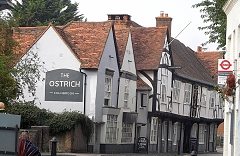
The George Inn, unlike the White Hart, is still in business. It is said that Princess Elizabeth, the future Queen Elizabeth I, might have spent a night there when being taken as a prisoner from Woodstock to Hampton Court in 1588. The pub was first established in the reign of Henry VIII. Its present façade is 18th century (www.sloughhistoryonline.org.uk). Other royal visitors to Colnbrook included the Black Prince with his prisoner King John of France, who were met here by King Edward III (reigned 1327-1377). The half-timbered Ostrich Inn, almost opposite the George, is far older and has a less salubrious history. Its foundations were laid in 1106 but much of its present construction is 16th century. Its name, the Ostrich, might well be a corruption of an earlier name, ‘the Hospice’.
During the 17th century, the Ostrich had an extremely dodgy landlord called Jarman. The pub’s website (https://ostrichcolnbrook.co.uk/history.html) describes his activities well. Here are some extracts from it. Jarman:
“…with his wife made a very profitable sideline by murdering their guests after they had retired for the night.
They had a trap door built into the floor of one of their bedrooms and when a suitably rich candidate arrived Jarman would inform his wife that a fat pig was available if she wanted one! She would reply by asking her husband to put him in the sty for till the morrow. The bedstead was hinged and they would tip the sleeping victim into a vat of boiling liquid immediately below, thus killing him.”
All went well for the Jarmans until they chose a clothier from Reading, named Thomas Cole:
“After persuading him to make his will before he retired, Jarman killed Cole. Unfortunately Cole’s horse was found wandering the streets nearby and caused a search for his owner who had been last seen entering The Ostrich! His body was found some time later in a nearby brook and some say that this Cole-in-the-brook is how Colnbrook got its name. It’s a nice story but whether it is true or not, who’s to say!”
You might be interested to learn that the Ostrich still offers rooms for guests to stay overnight. We met four men, who had done so, sitting quite contentedly in the morning sun that was flooding into the pub’s pleasant courtyard. Despite the story of Thomas Cole, it is far mor likely that the village was originally called ‘Colebroc’ (in 1107) and later ‘Colebrok’ (by 1222).
We visited the parish church of St Thomas just as guest were arriving at a christening. We were given a warm welcome by a female cleric dressed in white with a colourful stole, which she told us that she was wearing at such a happy occasion. The church, a Victorian gothic edifice, was designed by an architect who specialised in Gothic Revival, Benjamin Ferrey (1810-1880). Built between 1849 and 1852, it has walls containing flints. A north aisle, designed by a great practitioner of the Gothic Revival style, George Edmund Street (1824-1881), was added to the church in 1862.
Streams of the River Colne run through parts of the village. In some places their banks are lined with old houses, some half-timbered. Colnbrook, over which millions of people have flown since Heathrow was opened as Great west Aerodrome in 1929 and then as a much larger establishment, now known as London Heathrow, since 1946, is visited by few except mainly locals. Bypassed by major roads and not on the railway, the village has a picturesqueness that rivals many much more frequented places deep in the English countryside. Yet, Colnbrook is a short bus ride from Slough’s railway station and about 40 to 50 minutes’ drive from Hyde Park Corner. Visit the place and be surprised by its charm.
SINCE THE FOURTH OF JULY 2020, the anniversary of the day Britain lost a large American colony and when our worldly wise Prime Minister deemed it safe for all of us to be liberated from the constraints of ‘lockdown’ and encouraged us to ‘eat out to help out’, a policy that appears to have helped to spread the covid19 virus as well as restaurant owners, we have been roaming around the countryside, discovering what a beautiful country we inhabit. What has struck me when driving from A to B is the number of exceptionally attractive, yet not well-known, villages we have passed through. The village of Comberton in Cambridgeshire was one of these, which we nearly drove past without examining it. However, as time was on our side and it looked so lovely, we stopped there for a few minutes and took a stroll around.
We parked next to an oddly shaped small village pond in which clumps of reeds were growing. A small family of ducks wound its way between the vegetation, occasionally disappearing from view. At the far end of the pond, there is an old low brick wall. Behind it, there is a long two-storey house with a brick roof and decorative chimney stacks. Before describing some of the other lovely buildings in the village, let me give you a flavour of its history.
Sometime between 4000 BC and 2500 BC, someone dropped a polished Neolithic stone axe near where the village stands today. Somewhat later, the Romans built a villa near Comberton. Even later, the village’s name began to evolve, as is described on the village’s website (http://www.comberton.org/home/about-comberton/history-of-comberton/):
“A lot is said about the name of the village and its origins. It is believed that the name is of Celtic origin, possibly named after a landowner by the name of Cumbra. The Domesday Book (1086) has it recorded as Cumbertone. According to William Kip’s map of the area in 1607 Comberton is spelt as it is today and interestingly Barton is spelt Berton”
The village has several churches, which we will visit in the future. One of these is St Mary’s, is in the Early English style with later modifications. Another still extant place of worship is used by non-Conformists. There have been associations between non-Conformism and Comberton since as early as the 17th century. The Puritan William Dowsing (1596-1668), an iconoclast, visited the village in March 1643, and recorded:
“‘We brake downe a crucifix and 69 superstitious pictures we brake downe, and gave order to take downe 36 cherubims, and the steps to be taken down by March 25.’”
Prior to 1772, when a new road, a turnpike (now the A228), was built, Comberton was on the road connecting Oxford with Cambridge. Apart from the usual activities found in villages, such as butchery, bakery, saddlery, harness-making, inn keeping, blacksmithing, and so on, the place had one industry for a while. That was in the 19th century when Comberton became a small centre for mining coprolite, fossilised dung. This material used to be ground in a mill to produce a powder that made a good crop fertiliser. Judging by the good state of the houses and the high-quality cars parked near them, the inhabitants of Comberton appear make their living in reasonably well-paid jobs. Were I to have had a profitable career in or near Cambridge, this village might have been a good place to live.
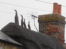
Every village is unique, but many share the same features. In Comberton, we saw several houses with well-maintained thatched roofs. However, we also saw something I had never noticed before. Some of the houses had what you might describe as ‘hybrid’ roofs: partly thatched and partly tiled. One house near the village pond had something we have seen on thatched roofs in many other villages. That is, the ridge of the thatch is decorated with animals made of thatch. Here in Comberton, this one roof was adorned with thatch sculptures of four birds with long necks, that made me think they are supposed to be depicting geese rather than ducks or swans.
The village pond, which is across the road from a dental surgery and ‘Millionhairz’, a hairdresser’s salon, is encircled by an attractive low, neatly built stone wall that curves around the water in a visually pleasant way. On the green next to the pond, there is a timber post that supports a sign (erected 1977) with the name of the village and a two-sided picture above it. On one side, a priest is depicted handing fishes to three people with outstretched arms. This refers to years long past when herrings were handed out to the poor in the village soon before Easter. The other side of the picture above the village name depicts a farmer ploughing his field with a plough drawn by a horse. Behind the farmer high on a hill, there is a white coloured wooden windmill. This reminds us that once Comberton had two working mills.
Our visit to Comberton lasted no more than ten minutes partly because we had to reach somewhere to meet my cousin and because the weather was miserable: grey, cold, and wet. However, what little we saw of this delightful place made us realise that it was well worth stopping en-route to our destination. We have already driven through so many intriguing villages on our excursions through the English countryside. I would have liked to spend time in all of these, and hope to return to some of them in the future. I would rather spend time wandering around picturesque villages than sitting for hours in traffic jams, as happens so often these days.