Wrecked, then recovered

Running track at Paddington Recreation Ground

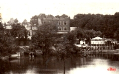
PADDINGTON RECREATION GROUND, located between West Kilburn and St John’s Wood, was formally established in 1893. It was London’s first public athletic ground. From 1860 to 1893, it was a parish cricket ground. In 1888, a cricket pavilion was constructed. It is now named after Richard Beachcroft who was Secretary of the cricket club in the 1880s. Also in 1888, the grounds were opened to public access and a cycle track was laid out, which remained in existence until 1987 when the position of the cricket pitch was moved. In 1893, the Paddington Recreation Act was passed, authorising:

“…the formal acquisition of lands in the Parish of Paddington to “provide the residents with a public recreational ground.” (https://en.wikipedia.org/wiki/Paddington_Recreation_Ground).

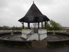
In 2006, the grounds were completely refurbished by Westminster City Council. The centrally located cricket pitch and its Victorian pavilion are now surrounded by a children’s playground; tennis courts; an outdoor gymnasium; a running track; hockey pitches; a bandstand; a bowling green; and various fenced off enclosures containing gardens and an ‘environmental area’. The pleasant park with its café and other facilities covers 27 acres and is well used by locals.

The Paddington Recreation Ground was a place where two world famous sportsmen trained. One was the professional road and track cyclist Sir Bradley Marc Wiggins (born 1980), who won the Tour de France in 2009. He learned to ride a bicycle in the grounds. He attended the St Augustines Church of England School nearby. The other sportsman was a medical student at the nearby St Marys Hospital when he trained on a running track at the Recreation Grounds, and on the 6th of May 1954, he became the first man to run a mile in under 4 minutes. This man was Sir Roger Bannister (1929-2018).

The Recreation Ground has several entrances. One of these is a short path leading from Carlton Vale. It runs past a pub called ‘The Carlton Tavern’, which has a curious recent history. In 1918, a German bomb destroyed a pub that stood on this site. In 1921, this was replaced for the Charrington Brewery by a newer building designed by Frank J Potter (1871-1948), who also designed the observatory in Hampstead. During WW2, the pub was the only building in the street not to have been destroyed during The Blitz. This plucky little pub’s luck ran out in 2015.

In 2015, developers bought the Tavern with a view to demolishing it to create space to build luxury flats. A week before the pub was due to become a protected historical edifice, the developers, no doubt having learned what was in the offing, reduced it to rubble. They hoped that they would get away with being fined an amount, which they could easily recoup when they sold the luxury accommodation they were planning to build. Things did not work out in their favour. Local action groups fought for the pub’s reconstruction and won. The courts ordered the developers to reconstruct the pub brick-by-brick (www.standard.co.uk/news/london/developer-told-to-rebuild-maida-vale-pub-brick-by-brick-after-site-torn-down-without-notice-10211892.html). They did a good job, and today it looks much as it did before it was hurriedly demolished.

Both the pub and the Recreation Ground stand in the shadow of the tall tower of the Anglo-Catholic Church of St Augustin. Known as ‘the cathedral of north London’, the church was designed in the gothic revival style by John Loughborough Pearson (1817-1897), who also designed Truro Cathedral in Cornwall. St Augustin was consecrated in 1880, but the tower and spire were not completed until 1897-98. I have never been inside this building, but I have seen photographs of its interior, which looks superb.

The places described above are almost all that remains of an area which has been subject to much rebuilding since WW2. Visiting these places can make an interesting detour when walking near Little Venice along the Paddington Arm (branch) of The Grand Union Canal. I doubt that I would have visited the Recreation Grounds had I not been alerted to it and encouraged to pay it a visit by two sets of friends, to whom I am grateful.

The Duke, his meadows, and the developers

DESPITE THE RAIN, we decided to walk along the path by the River Thames, proceeding upstream from Hammersmith. I had done this before, but never ventured beyond (i.e., upstream) the attractive church of St Nicholas, Chiswick, in whose graveyard you can find the funerary monument to the painter, William Hogarth (1697-1764), whose former home is nearby, and another to the Italian patriot, Ugo Foscolo (1778-1827). After walking along a riverside pathway that passes several recent, moderately attractive, but probably immoderately priced, housing estates, we reached Chiswick Pier at Corney Reach, whose name commemorates the now demolished Corney House, where Queen Elizabeth I was once entertained by the Earl of Bedford, who owned the place (www.chiswickw4.com/default.asp?section=info&page=conhistory29.htm).

Several lovely old houseboats are moored next to the pier. Near the jetty there is a noticeboard explaining the history of each of these vessels. Soon after this, the riverside path enters Dukes Meadow. Up to Barnes Bridge, which is a combined rail and pedestrian crossing over the river, the meadows form a grassy promenade running parallel to the Thames.  Beyond the bridge, the meadows widen out and extend to Great Chertsey Road that crosses Chiswick Bridge.

The bandstand at Dukes Meadow

The history of Dukes Meadow is recorded in a detailed essay by Gillian Clegg (https://brentfordandchiswicklhs.org.uk/dukes-meadows-the-threats-to-its-rural-survival/), from which I have extracted most of the following. In the past, the Meadow were low lying farmland and orchards prone to occasional flooding. The land was owned by the Dukes of Devonshire and cultivated by the Jessop family, then later farmed by John Smith of Grove Farm. Incidentally, one of  the Dukes, William, the 5th Duke of Devonshire (1748-1811), who had owned nearby Chiswick House in the 18th century. He had both enlarged the house (in 1788) and extended its grounds. At one time, the grounds of Chiswick House must have neighboured the Dukes Meadow. Ms Clegg noted that it was miraculous that the meadows survived as such considering the plans that were proposed for making use of it during the early 20th century.

Two plans were conceived for the ‘development’ of Dukes Meadow. The first was a housing scheme that was to be named ‘Burlingwick’. Clegg wrote:

“On 19 April 1902 The Times newspaper reported that ‘an influential body of capitalists’ had negotiated successfully with the Duke of Devonshire for 330 acres of land for a building plan to be called Burlingwick. The promoter, manager and developer of this scheme was Jonathan Carr, the developer of Bedford Park.”

Had this gone ahead, it would have created housing for up to 400,000 people and 330 acres of green land would have been lost to bricks and mortar. Fortunately, for reasons that are not now too clear the scheme was abandoned in about 1906.

1914 saw the next threat to the Meadows. The Brentford Gas Company planned to cover 80 acres of the Meadow with a huge gasworks. The people of Chiswick and other areas raised strong objections. The London “Times” of 6th February 1914 published its doubts about the scheme, which it said went against all the principles of good town planning, suggesting:

“…that land ripe for building – such as the Chiswick orchard farm – near the heart of the metropolis should be utilized for parks and garden settlement.”

The plan was scrapped, but what the “Times” had alluded to was later realised, but in a then novel way.

In 1923, the local council bought 200 acres of land from the then Duke of Devonshire. The land was to be used as a public recreation area complete with a riverside promenade, a bandstand, and a children’s area with paddling pools. All of this cost the council much money. To recoup some of what they had spent, they made an agreement with the Riverside Sand and Ballast Group. As Ms Clegg explained, the company:

“…was allowed to extract at least five acres every year in exchange for £1,500 an acre.”

The extraction of gravel proceeded from 1924 until 1937 and caused considerable damage to the area. Ms Clegg explained that when the land was finally returned to the council in 1948:

“The gravel pits were filled in, mainly with rubbish brought from inner London, and the area re-landscaped. Dukes Meadows has been described as one of the earliest and most impressive examples of restoration.”

Today, the promenade remains but I saw neither a children’s play area nor paddling pools, which still exist. The bandstand, which stands within a sunken circle lined with steps on which the audience can sit has a hexagonal tiled roof supported by six plain pillars. It is flanked on two sides by spacious shelters, also with tiled roofs. All their roofs are designed so that the angle (or degree) of pitch reduces noticeably about two thirds of the way from the top. Judging by their appearance, I would guess that these structures were built back in the early 1920s. This is confirmed by their appearance in a photograph taken during those years. Also visible in this picture are the unusual, twisted railings, looking like sugar-candy, running alongside the water, and supported by concrete posts with rounded tops. These are still in place today as are their concrete supports which bear simple decorative patterns. Some balustrading can be seen lining the waterfront near the bandstand (see quote below).

Part of the promenade leading towards Barnes Bridge from the Chiswick end of the Meadow is arranged in the form of two long steps. I have no idea why, but maybe they were once used by spectators watching boat races on the river. An article written in 1924 describes the popularity the Meadow with people watching the annual university boat race (http://dmtrust.dukesmeadowspark.com/newriversidepleasaunce.html):

“…in fact so many thousands of people availed themselves of this vantage point last Saturday week at the small admission fee charged by the Council, that over £1,000 net was raised towards the promenade project.”

 However, currently a line of bushes obscures sight of the river and the suburb of Barnes across it from these steps. A planning document produced in November 1923 (http://dmtrust.dukesmeadowspark.com/ariversideboulevard.html) sheds a little light on these steps:

“The Scheme, which received the first prize and was submitted by MR A. V. Elliot, of Chiswick, is reproduced on this page. It shows a series of terraces with a plateau of turf, showing seats and rustic shrubberies at intervals, and with a central feature of a bandstand and stone balustrading including a flight of steps and a causeway admitting to the river at all states of the tide.”

We enjoyed our stroll along the Dukes Meadow promenade even though the sky was grey, trees were dripping, and raindrops were falling intermittently. On our way back along the Thames Path to Hammersmith, we stopped at a charming Italian eatery and delicatessen on Chiswick Mall. The place, which is run by Sicilians, is called Mari Deli & Dining, and merits a visit to enjoy a good espresso, at the very least.

A hotbed of demoralisation and crime in north London

A WINDING LANE leads from Hampstead’s East Heath Road into the picturesque Vale of Health. I wrote about this isolated, small settlement surrounded by Hampstead Heath in the summer of 2017 (https://hampsteadadam.travellerspoint.com/2/) and have not revisited the place until today, the 2nd of January 2021. Little appears to have changed since then, but I have learnt a little more about the place.

As for its name, the place was not always as healthy as its name suggests. I wrote:

The land on which the Vale is situated is mentioned in the Domesday Book (1086 AD). It was then owned by the Abbots and monks of Westminster. By the 18th century this swampland in the middle of the part of the Heath, then known as part of ‘Gangmoor’, was inhabited by impoverished people and was malarial. In the 1770s, the area was known as ‘Hatches’ or ‘Hatchett’s’ Bottom, because Samuel Hatch, a harness-maker, had owned a cottage there before 1770. This unsavoury hollow was described in about 1817 as a “stagnate bottom, a pit in the heath” by the sculptor Joseph Nolleken’s wife (see: http://www.british-history.ac.uk/vch/middx/vol9/pp71-73). It was a vale, but not a healthy one.”

However, by 1801 when the land had been drained and property developers began building houses in the area, it gained the salubrious-sounding name by which it is known today.

Apart from the famous Indian artistic genius Rabindranath Tagore (1861-1941), who stayed in the Vale in 1912, the settlement was home to many other well-known people including the author Compton Mackenzie; the barrister Alfred Harmsworth; DH Lawrence; the philosopher Cyril Joad; and Stella Gibbons. Earlier notable residents included the law reformer Sir Samuel Romilly (1757-1818); the poet and essayist James Leigh Hunt (1784-1859), who entertained leading literary figures such as Hazlitt, Keats, Lord Byron and Shelley in his house in the Vale; the publisher Charles Knight (1791-1873); and, also, a Prince Eszterhazy.

During the 19th century, not only were the literati and wealthy attracted to the Vale but also it was a popular place for hoards of trippers, whose names never made it into the annals of history. The author of “The Northern Heights of London” published in 1869, William Howitt (1792-1879), describes these pleasure-seekers and what they did in some detail. He wrote that:

“This Vale of Health used, till of late years, to present a sight at once picturesque and pleasant. In front of a row of cottages, and under the shade of willows, were set out long tables for tea, where many hundreds, at a trifling cost, partook of a homely and exhilarating refreshment. There families could take their own tea and bread and butter, and have water boiled for them, and table accommodation found for them, for a few pence…”

And then, everything changed for the worse according to the puritanical-sounding Howitt:

“Recent times have seen Sunday dissipation reasserting itself, by the erection of a monster public house with a lofty tower and flag, to attract the attention of Sunday strollers on the Heath. Of all places, this raised its Tower of Babel in that formerly quiet and favourite spot, the Vale of Health … that taps and gin palaces on a Titan scale should be licensed, where people resort ostensibly for fresh air, relaxation, and exercise, is the certain mode of turning all such advantages into popular curses and converting the very bosom of nature into a hotbed of demoralisation and crime…”

This demoniacal-sounding establishment is marked as ‘Suburban & Hampstead Heath Hotel’ on a map surveyed a year before Howitt’s book was published. On a map surveyed in 1912, it is marked simply as ‘Hotel’. Just a few houses away southwest of it, another building is marked ‘Hall’, to which I will refer shortly. According to both maps, the hotel stood where today there is a twentieth century block of flats called Spencer House. Opposite this edifice, there is a caravan park, which has been in the possession of the Abbotts family for over 160 years. Since the late 19th century, this patch of land has been fairground land. About ten members of the family live on the site in caravans, and other travelling fair workers can camp there free of charge. In exchange, members of the Abbott family, who operate travelling fairs, are allowed camp for nothing on other fairground owners’ sites when they travel around the country.

Returning to the building that upset Howitt, “A History of the County of Middlesex: Volume 9” (https://www.british-history.ac.uk/vch/middx/vol9/pp71-73) notes:

“… the Suburban hotel (also called the Vale of Health tavern) with towers and battlements and accommodation for 2,000 was built in 1863 …”

This source also notes another establishment, which was being built whilst Howitt was writing or just about to publish. This was the ‘Hampstead Heath Hotel’, which was built in 1868. This stood between two groups of ‘villas’, that is between 1-6 Heath Villas and 7-12 Heath Villas. It was the building marked as ‘Hall’ on the 1912 map. It is now occupied by a mid-twentieth century block of flats, smaller than Spencer House, named ‘Athenaeum’.

The Hampstead Heath Hotel closed in 1877, when it passed into the ownership of Henry Braun. His great grandson, Frances Francis wrote (www.francisfrith.com/uk/hampstead/vale-of-health-hotel_memory-7431):

“My great grandfather Henry Braun owned the Vale of Health Hotel … overlooking the lake, from 1877 until the early 1900’s. The hotel was used as an Anglo German club called the Athenaeum and by 1908 had 1200 members – 500 English, 700 German, including many political radicals. The hotel became a factory during World War I and then remained derelict for some years. The hotel was eventually pulled down in 1958, when I was 15 and I remember with sadness watching ‘luxury’ flats being erected in its place.”

The club closed in 1914 and then became used as a factory until it was demolished and replaced by the present building in 1958.

According to the County History to which I have already referred, The Athenaeum club’s larger neighbour, the hostelry that Howitt detested was:

“The large Vale of Health tavern, originally intended as a hotel and sanatorium, was sold in 1876, became associated with the fair, was let as flats, and c. 1900 became a hotel again on a smaller scale, with the upper rooms let as studios … Spencer House (flats) replaced the Vale of Health hotel in 1964.”

Howitt would have been even more dismayed to have learnt that there was a third hotel built in the Vale of Health in the 1880s. It stood next to the Athenaeum on the site now occupied by Byron Villas. It was at number 1 Byron Villas that the writer DH Lawrence lived in 1915.

Today, Howitt would most probably be happier with the Vale of Health than he was in 1869. The hotels have gone, and there is not even the tiniest of stalls where refreshments may be obtained. He might disapprove of the parked cars and the caravan site opposite Spencer House, but there would be hardly anything that he could find to decry.  By the edge of its large pond, one of the sources of the River Fleet, the Vale of Health remains a quiet oasis in the heart of north London.

Make park, not war

BY FEBRUARY, daytime temperatures in Pondicherry exceed 30 degrees Celsius. This combined with high humidity levels drive the wild street dogs to sleep a lot in whatever shade they can find. Likewise, sensible people avoid direct exposure to the strong tropical sun.

When you walk along the paths shaded by trees in the centrally located Bharathi Park, you can feel the temperature drop. This park, a peaceful haven, was an unforeseen result of warfare.

In 1709, the French built a fortress, Fort Louis, in the heart of Pondicherry. It was a typical fortress of the type designed by the French engineer Vauban (1633-1707). Pentagonal in plan, it had bastions at each of its five corners. The fort was destroyed by the British in 1761 and not replaced.

The space left after the destruction of the fort remained a wasteland used by the French for military training and celebration of some French national festivals. In 1854, an elegant neoclassical pavilion was erected in the middle of this wasteland. It commemorates a legendary 16th century woman, who discovered a source of water that became very important for the inhabitants of Pondicherry.

In 1946, a tree was planted on the land where Fort Louis once stood. Eventually, the present Bharathi Park was laid out. In its middle, stands the pavilion mentioned already.

One entrance to the park is opposite the entrance to the heavily guarded Raj Nivas (Governor’s Residence), housed in the former French Governor’s House built in 1766.

At the north east corner of the park, there is a statue of a man wearing a dhoti, a long jacket, and a turban. This depicts Chinnaswami Subramania Bharathi (1882-1921), also known as ‘Bharatiyar’. He was a great Tamil poet and independence fighter and opponent of the caste system. He fled to Pondicherry in 1908 to escape from being arrested (for his ‘seditious’ writing in newspapers) by the British and remained there until 1918. In 1906, he edited a newspaper with MPT Acharya, about whom I have written in my book about Indian revolutionaries in London, “Ideas, Bombs, and Bullets”. In Pondicherry, Bharatiya met other Indian freedom fighters seeking sanctuary there, including Sri Aurobindo and VVS Aiyar (also in my book), an associate of Vinayak Damodar Savarkar.

In 1918, Bharatiya moved back into British India, where he was promptly arrested. He died in 1921, impoverished.

The Puducherry Government Museum, housed in an 18th century French mansion, is a few metres from the park and well worth a visit. It contains exhibits dating from prehistory until the era of the French colonization. In need of a little bit more care and attention, there is a fascinating range of objects to be seen.

One display that interested me greatly was about the excavations made by a French archaeologist and the British Sir Mortimer Wheeler at Arikamedu, just south of Pondicherry. They were following up discoveries made in that location by French scholars before WW2. It emerged that Arikamedu was the site of a port at which Ancient Romans and Greeks traded with the local Indians.

The museum contains a few artefacts dug up including some Roman and Greek coins. A few years ago, I saw many of these in a museum at Calicut.

The ports where the Mediterranean people traded in India are contained in “The Periplus of the Erythraean Sea”, a navigational manual that was originally composed in the 1st century AD. The port near Arikamedu is most likely to have been ‘Podouke’ as listed in the “Periplus”.

So, it is evident that the area around Pondicherry was visited by Europeans long before the British, French, and Danes estsblished colonies there.

We left the museum, which also has a nice collection of Hindu sculptures, and the lovely park to enjoy some excellent French inspired cooking at the Villa Shanti. At the table next to ours, there was a very serious looking group of French tourists, who were listening earnestly to their Indian guide, who spoke to them in French with an accent that probably caused them to wince internally. Incidentally, apart from people from all over India, most of the rest of the visitors to Pondicherry are French. I wonder how they feel seeing the souvenirs of their former empire, now an episode fading into the swirling mists of time.