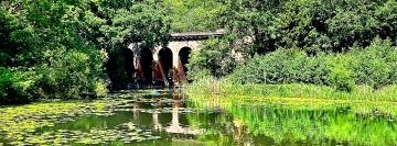
WHEN STROLLING ON Hampstead Heath, you might come across a series of ponds. These are known as the Hampstead Ponds. An elegant brick viaduct crosses one of these ponds quite picturesquely. It seems to be a connection between two points of no special significance. In my book “Beneath a Wide Sky: Hampstead and its Environs”, I mention the history of the viaduct as follows:
“The Hampstead Ponds, now three in number, are fed by streams that rise near the Vale of Health, which is northwest of the uppermost pond, the Mixed Bathing Pond. The latter flows into the second pond and then down into the first, the lowest. These streams, along with those that flow into the Highgate Ponds, are sources of the water that flows in the now subterranean River Fleet, which empties into the Thames under Blackfriars Bridge. Northeast of the upper pond, that which is used by swimmers, is Viaduct Pond. This is so named because it is traversed by a brick viaduct, built between 1844 and 1847. This structure was to have been the grand entrance to an estate of residential villas that Sir Thomas Maryon-Wilson had hoped to build on the Heath but was prevented by local opposition.”
Luckily, Sir Thomas was prevented from constructing homes on Hampstead Heath, because if he had done so, a valuable outdoor amenity, part of the Heath, would have disappeared. Equally luckily, his viaduct has remained, making it a surprisingly beautiful feature within a largely wooded area.
WHENEVER WE VISIT the Newport Street Gallery in London’s Lambeth district, we pass the entrance to a small garden. Today (19th of June 2024), we decided to enter this little park – a peaceful haven only a few hundred yards south of Lambeth Bridge. It is called Old Paradise Gardens. Irregular in shape, it has one long main path leading from its northern entrance in a southeasterly direction towards its southern entrance, close to a busy railway line. Near the northern entrance, there is a small fenced off area, which is being developed as a community garden in collaboration with the nearby Garden Museum (next door to Lambeth Palace). Not being botanically knowledgeable, I cannot describe the wide variety of plants growing in the Gardens, but I can say that they make for an extremely pleasant green environment.
We saw a few worn, illegible tombstones propped up against one of the garden’s walls. These provide an important clue about the history of the Gardens. The place was:
“…previously a burial ground provided to the parish by the Archbishop of Canterbury in 1703. It was extended in 1816, but by 1853 was full and closed to burial. In 1880 it was decided to convert it into a public garden, which opened in 1884. Gravestones were moved to boundary walls … The recreation ground was extended in 1929 and by the 1970s was largely asphalted. Since re-landscaped, it has grassy mounds, a water feature, with shrubs and spring bulbs planted. In 2013 refurbishment was completed and the park was renamed Old Paradise Gardens. In 2023 a new community garden was introduced in the southeast corner designed by Dan Pearson Studios under the leadership of The Garden Museum nearby.” (https://londongardenstrust.org/conservation/inventory/site-record/?ID=LAM026&sitename=Old+Paradise+Gardens)
When we visited the Gardens at about 11 am today, we saw few other people. Probably, at weekends and after school is over, this delightful little open space becomes busier. It is always lovely to ‘discover’ yet another of London’s numerous green spaces – about 40% of London’s area is occupied by public green spaces.
If you happen to be in need of refreshment whilst visiting the Old Paradise Gardens, head for the elegant café attached to the nearby Garden Museum.
OVERLOOKED BY GOLDFINGER’S brutalist block of flats and hemmed in by Elkstone Road, Golborne Road, and the tracks of the Great Western Railway, there is a small patch of ground that serves as a little haven. Usually occupied by a few local characters, this space measures about 40 by 13 yards. It is The Elkstone Road Garden Oasis.
A curved wall at its northern end is covered with well painted murals depicting musicians and other figures, who I guess might be portraits of people well-known to those who use the garden. There are plenty of plants in this little oasis. Some of them are plastic artificial flowers picturesquely positioned. Others are real. Some of them have little notices next to them, identifying and explaining something about them. There are also printed notices that contain worthy thoughts about life. Amongst the rather tatty chairs, tables, and a small bookshelf, there is a wooden bench with a label stating that it was donated to a parochial organisation by the Chelsea Physic Garden. An online article published in 2018 (https://communityreporter.net/story/oasis-north-kensington-4-jun-2018-1249) revealed:
“The Elkstone Road Garden Oasis in fact, a small strip of land with a history of being neglected and abused. Originally rescued by the work of MIND volunteers the Oasis is now being managed by the Chelsea Physic Garden, which enjoys a somewhat longer history being created in 1683. Building on the work completed by MIND the Physic Garden, with grants from the Royal Borough of Kensington and Chelsea, Band Trust, City Bridge Trust and Turning Point, seeks to provide the local community with a beautiful space, in which the people who live in this area, adults and children, can enjoy being involved in the world of plants and wildlife. Colville Primary school are already participating in developing the garden, with visits every Thursday by Year three pupils. This is a popular activity and always provides a healthy injection of enthusiasm into the Garden.”
Long before Trellick Tower was constructed in the early 1970s and when Elkstone Road was named ‘Southam Street’, the area now occupied by the open space and that where Trellick Tower now stands was covered with rows of small, terraced houses. Unlike the nearby Meanwhile Garden (running alongside the Grand Union Canal), which is well-documented, the small, rather quirky open space I have described above seems to be slightly ‘off the radar’.
THE RIVER BRENT is a major tributary of London’s River Thames. It has two main sources: one, which feeds into Dollis Brook, is west of Barnet; the other, which feeds into Mutton Brook, is near East Finchley. As a child, Mutton Brook figured amongst the places where I used to play with my friends. It flows through Hampstead Garden Suburb (‘HGS’) where I lived during the first three decades of my life. In those far-off days, I had no idea that the then rather malodorous, winding Mutton Brook flowed into the Thames. Mutton and Dollis Brooks merge to become the Brent near Golders Green. The Brent flows through northwest and then west London to reach its junction with the Thames at Brenford, an interesting place, rich in history, described in my book “Beyond Marylebone and Mayfair: Exploring West London”.
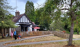
The cafe in Pitshanger Park
On its way to the Thames, the Brent skirts another garden suburb, Brentham Garden Suburb (‘BGS’), which, like HGS, was an attempt to create a leafy residential Utopia. They were built at roughly the same time. The northern edge of BGS borders Pitshanger Park, through which the Brent winds its way towards the Thames. The name of the park derives from the Putelshanger or Pitshanger family, who occupied the area in the 13th century. The manor occupied the area between Hanger Hill and the Brent. Until 1908, when it was demolished, the manor house (and its antecedents), known as ‘Pitshanger farmhouse’, occupied a plot on the present Meadvale Road, which runs along the northern edge of BGS. This building was completely different to Pizhanger Manor near Ealing Broadway, which was built by John Soane (and is described in my book).
Pitshanger Park is laid out on what used to be part of the grounds of Pitshanger farmhouse. BGS was built on another part of that same estate. The park is adjacent to Ealing Golf Course. Both were already in existence by 1912. The Brent also runs through the golf course. While we were visiting the park, we watched two men leaning over the bank of the river, rather ineffectually attempting to recover a ball from the weeds growing beside the water.
The park consists mainly of spacious grassy meadows that are bordered to the north by dense bushes and trees lining the bank of the Brent. Amenities offered in the park include, tennis courts, outdoor exercising equipment, and an attractive children’s play area. Housed in a small building with fake half-timbering, there is a small café with a terrace on which there are tables and chairs. The ‘caf’ offers hot and cold drinks and a few snacks. Its staff are pleasant, and the washrooms were clean.
While Pitshanger Park cannot be classed as one of London’s more exceptional open spaces, it is a wonderful amenity for residents in the area, just as was (and still is), the public gardens in HGS through which Mutton Brook flows.
DESPITE THE RAIN, we decided to walk along the path by the River Thames, proceeding upstream from Hammersmith. I had done this before, but never ventured beyond (i.e., upstream) the attractive church of St Nicholas, Chiswick, in whose graveyard you can find the funerary monument to the painter, William Hogarth (1697-1764), whose former home is nearby, and another to the Italian patriot, Ugo Foscolo (1778-1827). After walking along a riverside pathway that passes several recent, moderately attractive, but probably immoderately priced, housing estates, we reached Chiswick Pier at Corney Reach, whose name commemorates the now demolished Corney House, where Queen Elizabeth I was once entertained by the Earl of Bedford, who owned the place (www.chiswickw4.com/default.asp?section=info&page=conhistory29.htm).
Several lovely old houseboats are moored next to the pier. Near the jetty there is a noticeboard explaining the history of each of these vessels. Soon after this, the riverside path enters Dukes Meadow. Up to Barnes Bridge, which is a combined rail and pedestrian crossing over the river, the meadows form a grassy promenade running parallel to the Thames. Beyond the bridge, the meadows widen out and extend to Great Chertsey Road that crosses Chiswick Bridge.
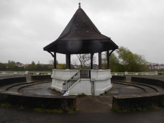
The bandstand at Dukes Meadow
The history of Dukes Meadow is recorded in a detailed essay by Gillian Clegg (https://brentfordandchiswicklhs.org.uk/dukes-meadows-the-threats-to-its-rural-survival/), from which I have extracted most of the following. In the past, the Meadow were low lying farmland and orchards prone to occasional flooding. The land was owned by the Dukes of Devonshire and cultivated by the Jessop family, then later farmed by John Smith of Grove Farm. Incidentally, one of the Dukes, William, the 5th Duke of Devonshire (1748-1811), who had owned nearby Chiswick House in the 18th century. He had both enlarged the house (in 1788) and extended its grounds. At one time, the grounds of Chiswick House must have neighboured the Dukes Meadow. Ms Clegg noted that it was miraculous that the meadows survived as such considering the plans that were proposed for making use of it during the early 20th century.
Two plans were conceived for the ‘development’ of Dukes Meadow. The first was a housing scheme that was to be named ‘Burlingwick’. Clegg wrote:
“On 19 April 1902 The Times newspaper reported that ‘an influential body of capitalists’ had negotiated successfully with the Duke of Devonshire for 330 acres of land for a building plan to be called Burlingwick. The promoter, manager and developer of this scheme was Jonathan Carr, the developer of Bedford Park.”
Had this gone ahead, it would have created housing for up to 400,000 people and 330 acres of green land would have been lost to bricks and mortar. Fortunately, for reasons that are not now too clear the scheme was abandoned in about 1906.
1914 saw the next threat to the Meadows. The Brentford Gas Company planned to cover 80 acres of the Meadow with a huge gasworks. The people of Chiswick and other areas raised strong objections. The London “Times” of 6th February 1914 published its doubts about the scheme, which it said went against all the principles of good town planning, suggesting:
“…that land ripe for building – such as the Chiswick orchard farm – near the heart of the metropolis should be utilized for parks and garden settlement.”
The plan was scrapped, but what the “Times” had alluded to was later realised, but in a then novel way.
In 1923, the local council bought 200 acres of land from the then Duke of Devonshire. The land was to be used as a public recreation area complete with a riverside promenade, a bandstand, and a children’s area with paddling pools. All of this cost the council much money. To recoup some of what they had spent, they made an agreement with the Riverside Sand and Ballast Group. As Ms Clegg explained, the company:
“…was allowed to extract at least five acres every year in exchange for £1,500 an acre.”
The extraction of gravel proceeded from 1924 until 1937 and caused considerable damage to the area. Ms Clegg explained that when the land was finally returned to the council in 1948:
“The gravel pits were filled in, mainly with rubbish brought from inner London, and the area re-landscaped. Dukes Meadows has been described as one of the earliest and most impressive examples of restoration.”
Today, the promenade remains but I saw neither a children’s play area nor paddling pools, which still exist. The bandstand, which stands within a sunken circle lined with steps on which the audience can sit has a hexagonal tiled roof supported by six plain pillars. It is flanked on two sides by spacious shelters, also with tiled roofs. All their roofs are designed so that the angle (or degree) of pitch reduces noticeably about two thirds of the way from the top. Judging by their appearance, I would guess that these structures were built back in the early 1920s. This is confirmed by their appearance in a photograph taken during those years. Also visible in this picture are the unusual, twisted railings, looking like sugar-candy, running alongside the water, and supported by concrete posts with rounded tops. These are still in place today as are their concrete supports which bear simple decorative patterns. Some balustrading can be seen lining the waterfront near the bandstand (see quote below).
Part of the promenade leading towards Barnes Bridge from the Chiswick end of the Meadow is arranged in the form of two long steps. I have no idea why, but maybe they were once used by spectators watching boat races on the river. An article written in 1924 describes the popularity the Meadow with people watching the annual university boat race (http://dmtrust.dukesmeadowspark.com/newriversidepleasaunce.html):
“…in fact so many thousands of people availed themselves of this vantage point last Saturday week at the small admission fee charged by the Council, that over £1,000 net was raised towards the promenade project.”
However, currently a line of bushes obscures sight of the river and the suburb of Barnes across it from these steps. A planning document produced in November 1923 (http://dmtrust.dukesmeadowspark.com/ariversideboulevard.html) sheds a little light on these steps:
“The Scheme, which received the first prize and was submitted by MR A. V. Elliot, of Chiswick, is reproduced on this page. It shows a series of terraces with a plateau of turf, showing seats and rustic shrubberies at intervals, and with a central feature of a bandstand and stone balustrading including a flight of steps and a causeway admitting to the river at all states of the tide.”
We enjoyed our stroll along the Dukes Meadow promenade even though the sky was grey, trees were dripping, and raindrops were falling intermittently. On our way back along the Thames Path to Hammersmith, we stopped at a charming Italian eatery and delicatessen on Chiswick Mall. The place, which is run by Sicilians, is called Mari Deli & Dining, and merits a visit to enjoy a good espresso, at the very least.
I HAVE BEEN FORTUNATE to have lived in parts of London close to large green open spaces. When I was at secondary school in Highgate (north London), I could walk there from my home in Hampstead Garden Suburb, hardly needing to walk along streets. It was a short distance from my house to the grassy Hampstead Heath Extension. From there, I crossed a road to enter the wooded part of Hampstead Heath through which I walked to the Spaniards Inn. Then a few hundred yards of pavement followed before I entered the pleasant landscaped grounds of Kenwood House. Walking through this lovely park brought me to within a few hundred yards of my senior school.
When I was a student at University College London (‘UCL’), I was able to walk there through green areas most of the way from my family home. By walking the length of Hampstead Heath Extension, and then strolling southwards across the eastern part of Hampstead Heath, I reached South End Green. From there, I had to tramp the streets towards Primrose Hill, where once again my feet were on grass instead of paving stones. Primrose Hill led straight to Regents Park and from that splendid open space, it was a short walk along pavements to UCL.
Since marrying over 27 years ago, we have lived close to the northwest corner of Kensington Gardens. We are about three to four minutes’ walk away from the gardens depending on whether the pedestrian traffic lights are in our favour or not. We can traverse Kensington Gardens, passing close to the so-called Round Pond and then reaching The Serpentine Lake, where maybe one might stop for a coffee at the café by the Lido on the Serpentine. From there, it is not a long distance to the southeast corner of Hyde Park, which is next to Hyde Park Corner, a small green space ringed by busy roads. After crossing Hyde Park Corner, maybe having walked beneath Wellington Arch, which is surmounted by a metal quadriga, one road needs traversing before entering Green Park, which lives up to its name with its expanses of lawn and rows of mature trees. If you wish, you can walk along the northern fringe of Green Park to reach the eastern third of Piccadilly, and then you have arrived in the heart of the West End hardly having stepped upon the pavements lining busy streets.
After walking east through Green Park, one reaches the Mall and the front of Buckingham Palace. Cross the Mall and then you are in St James Park. By crossing this beautiful green space, you will soon reach Parliament Square and beyond it the Thames and the South Bank area.
Let us linger awhile in St James Park. The feature that endears me to this London Park is the St James Park Lake and its rich assortment of waterfowl. The park was established by King Henry VII on marshland watered by the now no longer visible Tyburn River, which runs in underground conduits. The lake, probably designed by the French landscape designer André Mollet (d. before 16 June 1665), began life as a canal dug for King Charles II. The king used it for swimming in the summer and for skating when it froze in the winter (a rare occurrence nowadays, thanks to the so-called ‘global warming’ that many believe is occurring).
There is a pedestrian bridge across the water, two islands, and a fountain, in the lake. A wide variety of ducks, swans, geese, herons, cormorants (or shags), and other birds congregate in and around the water. This is nothing peculiar. You can see the same in The Round Pond, the Serpentine Lake, and many other water bodies that are dotted liberally across Greater London. However, St James Park offers one kind of bird that you will not find anywhere else in London except at the Zoo. The park is home to a small population of pelicans. These creatures are often hard to see as they usually perch on the islands in the lake, but yesterday, the 11th of October 2020, at least three of them were walking fearlessly (it seemed) along the edge of the lake close to admiring visitors including my wife and me.
In 1664, during the reign (1660-1685) of King Charles II of England, Scotland and Ireland, pelicans were first introduced into St James Park. These distinctive long billed birds, which symbolise the Passion of Jesus and the Eucharist in Christian symbolism, were gifts of the Russian Ambassador, who knew that the king appreciated exotic waterfowl. Charles was presented with two grey or Dalmatian pelicans (Pelicanus crispus). Sadly, they did not breed successfully, and the park needed to be replenished with new specimens occasionally. An article in the online version of “Country Life” (www.countrylife.co.uk/out-and-about/dogs/st-jamess-park-pelicans-sparked-cold-war-stand-off-russia-usa-171954), published in January 2018, reveals:
“The Russian Embassy’s custom of occasionally presenting new pelicans continued during and after the Soviet era and other organisations – such as the City of Prague in 2013 – have also added to the birds’ numbers.”
However, a diplomatic incident erupted in the 1960s, when:
“… London’s Royal Parks accepted some American pelicans for the lake in St James’s Park … According to Foreign Office tradition, the presence of the American pelicans resulted from a Cold War rivalry between the American and Soviet Embassies. One day, a newly accredited US Ambassador called on the Foreign Secretary, whose office overlooks the lake. He noticed the pelicans and was informed about their history and origin.
Determined not to be upstaged by the Soviet Ambassador, his opposite number announced that he, too, would be presenting some pelicans – American ones – to grace the lake, an offer that the Royal Parks management accepted gratefully.
When the American pelicans duly arrived, they were, predictably, not friendly to their Russian counterparts. Indeed, rather mysteriously, they failed to flourish and seemed miserable. The US Embassy suspected the Soviet Embassy of harming the American pelicans – which the Russians denied – and relations between the embassies became glacial.”
That incident is something that we did not see recorded on any of the numerous informative signs placed near the perimeter of the lake.
Londoners are most fortunate to have so many green spaces often within easy walking distance from their homes. Many other great cities of the world do have significantly large public green spaces, for example Central Park in New York, Cubbon Park in Bangalore, the Bois de Boulogne in Paris, and Kalemegdan in Belgrade, but few have so many as liberally distributed across their areas as does London. Being within walking distance of both Kensington Gardens and Holland Park during our recent severe month’s long ‘lockdown’ helped raise our spirits during this bleak period. Not only was the walking we did good for our spirits, but it gradually increased the distance that we can walk comfortably before becoming physically fatigued. Even when eventually the pandemic of covid19 dies down, we might well think twice about taking public transport now that we know how pleasant it is to walk instead.