
Crown’d with thatch
Wov-en together with skill
And lo, you find a good wall

Crown’d with thatch
Wov-en together with skill
And lo, you find a good wall
A FRIEND INVITED us to dine one evening at the exclusive Mosimann’s Club in West Halkin Street in London’s elegant Belgravia district. As it was dark when we arrived and I was too busy chatting with our host, I failed to notice the exterior of the establishment. Years later, I noticed that the narrow façade of this fancy eatery, named ‘The Belfry’, is that of a Victorian gothic church with a slender spire.

The church was being used by the Presbyterians in 1866, so wrote Edward Walford in the 1880s. The website of The London Metropolitan Archives catalogue reveals more:
“…a chapel was built on Lower George Street, called the Ranelagh Chapel. In 1845, on the death of the Methodist minister, the church joined the English Presbyterian Church and was renamed Ranelagh Presbyterian Church. The lease on the Lower George Street chapel expired in 1866 and the church merged with a Presbyterian Mission in West Halkin Street, Belgrave Square. The name Belgrave Presbyterian Church was adopted. The church was rebuilt in 1881. In 1923 the church moved to premises in Emperor’s Gate, Kensington.”
The former church is an unusual structure in that the end facing the entrance is considerably wider than the façade. As to when it was originally built, I am uncertain. Nikolaus Pevsner, the architectural historian, does not give it a mention in his extremely detailed guide to the buildings of the City of Westminster in which it is located. However, he does mention the chapel’s neighbour, to the left of it as you face the façade. Far more attractive than the chapel is the façade of its neighbour which is decorated in a neoclassical style. It has two porticos supported by pillars with Doric capitals. This building was built in about 1830.
Today, the Doric pillars flank entrances to a branch of Waitrose food stores. This shop also has an entrance on the street parallel to West Halkin Street, Motcombe Street. Thus, two temples of food stand side by side. If you cannot afford to dine in the former church, then you can console yourself and appease your appetite by acquiring something edible in Waitrose by stepping between the Doric pillars. In case you are wondering what we ate at Mosimann’s, I am afraid I cannot recall as it was so long ago, but I do remember enjoying it.
IF YOUR TRAIN FROM CAMBRIDGE to London stops at Shepreth and Meldreth, you can be sure that you are in for a longish journey because only the slower trains halt at these stations. Over the course of many years, we have been travelling to and from Cambridge by train and as I enjoy looking out of the window, I have always noticed this pair of oddly named stations. Only recently, we visited both places by car and took a look around these lovely villages between Cambridge and Royston and close to the A10 road, which runs from London Bridge to Kings Lynn via Cambridge.

The ‘reth’ suffix in the two villages names means ‘stream’. Shepreth means ‘sheep stream’ and Meldreth means ‘mill stream’. There is archaeological evidence of settlements in both places long before the Romans invaded England. The Romans may have occupied part of the parish of Shepreth and their successors, the Saxons, developed the village of Meldreth. Both villages are listed in the Domesday Book (1086). Little appears to have been recorded in the history books about events in tiny Shepreth. The larger village of Meldreth also played no great role in the history of England but, in the 16th century, Christ College of Cambridge moved to its estate near the village to escape from the plague. Members of the Meldreth Local History Group might disagree with my assessment of Meldreth’s place in British history. Their superb website (meldrethhistory.org.uk/) details many aspects of the place’s past, but most of them are about the village rather than the wider world.
I imagine that the building and opening of railway stations in the two villages in 1851 were major events in their history and development. Currently, the stations are served by Thameslink trains. The villages are popular places for commuters to both London and Cambridge.
Both villages are rich in historic buildings of great beauty. Many features of vernacular architecture can be found including many fine thatched roofs. A particularly charming old, thatched edifice In Shepreth is Corner Cottage, which is close to a more aristocratic looking building, Docwra House. This former manor house was built in the 17th century and then provided with later additions (www.docwrasmanorgarden.co.uk/history.htm). The village sign at Shepreth is suitably adorned with sheep, bales of fleece, a stream, a bridge, a water mill, and a leaping fish. The bridge, which we did not see, was built in the 17th century. It crossed the River Rhee, a tributary of the River Cam, in which sheep were washed, and was used by farmers taking sheep to the market in Cambridge.
At Meldreth, through which flows the tiny River Mel, a tributary of the Cam, we entered the parish church of Holy Trinity, whose construction began in the mid-12th century on the site of an 8th century church. Its square tower, nave, and chancel were all constructed in the 12th century. The church contains some fine brass chandeliers; an elaborately carved pulpit and choir stalls with wooden carvings; fragments of pre-Reformation frescoes; a lovely timber beam ceiling; some heavily whitewashed carvings supporting some of the ceiling timbers; and a mediaeval parish chest. The latter is one of about 150 surviving examples. It was made in Baltic pine with iron bands between about 1400 and 1420 and was used for securely storing valuable liturgical items (e.g., silverware, books, and vestments). In addition to visiting the church, we drove through long village to its station, which up until our visit by car, we had only ever seen whilst speeding through it by train. However, we did not see any mills as suggested by the meaning of the name Meldreth.
We did not spend nearly enough time in the two villages as we fitted them into an already busy day of sightseeing. However, having sampled them, we feel that they merit a longer visit in the future. Once again, these places provide good examples of the wealth of historical features to be discovered in England’s rural areas.
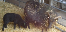
Winter is now over
Some new lambs are born:
Such is the cycle of life
BEFORE THE ADVENT of railways, transportation of goods across England (as well as Wales and Scotland) was heavily dependent on an extensive canal system constructed mostly in the 18th and early 19th centuries. Freight was carried along these canals in the holds of long narrow barges, more correctly known known as ‘narrow boats’. They had to be narrow enough to negotiate some of the narrower canals that formed part of the canal network. Prior to the development of steam and other kinds of engines, and even for some years after these became available, the narrow boats were towed by horses. These creatures walked along paths known as ‘towpaths’ that run along one or other side of a canal, except when a canal passed through a tunnel. In the tunnels there were no towpaths, and the boats were propelled by the feet of men lying either above the load on the boat or sometimes on planks projecting from the sides of the vessel, a process known as ‘legging’. The boatmen’s feet literally walked along the tunnel walls, thus moving the boat. Meanwhile, the towing horses walked over the hill through which the tunnel passed. All of this interesting but becomes even more so if you can experience a trip on a canal in a narrow boat.

Several companies offer canal trips between Little Venice (near London’s Paddington) and Camden Lock, east of it. We chose to travel on “Jason”, a narrow boat built in 1906 and one of the last of its era, which is still in use. “Jason” has been little modified compared to others that ply the route along the Regents Canal, a branch of the Grand Union Canal system. “Jason”, which was originally horse-drawn, has been fitted with a diesel engine that occupies part of the small rear located cabin that was once the home to a boatman and his family. Passengers sit in the long, narrow freight hold of the boat under an awning that was added when “Jason” was converted from a freight carrier to a tourist vessel, which has been doing the tours since 1951. Unlike most of the other tourist boats, there are no windows separating passengers from the exterior. This provides for great viewing along the route without the hindrance of sometimes not too clean glass, which might be encountered in other vessels.
The tour starts from a landing stage next to Blomfield Road, close to the cast-iron bridge that carries Westbourne Terrace Road over the Paddington Arm of the Grand Union Canal. At the other end of the trip, passengers disembark or embark next to the popular (not with me) and rather ‘tacky’ Camden Lock Market. The cruise between the two landing stages takes 45 minutes and is highly enjoyable. Travelling eastwards from Little Venice, we were given an extremely clear and intelligent commentary by a lady called Sarah. Various things she told us made a strong impression on me.
The Regents Canal that links Paddington Basin to Limehouse Basin in east London, where it leads to other canals, used to carry a wide range of goods, from coal to cocoa. The waterway passes under both rail and road bridges. Many of the latter have curved arches over the canal; are made of stone; and look older than the rail bridges, most of which have rectangular arches with roofs consisting of metal plates screwed together. Over the years, the tow ropes drawing the narrow boats have cut grooves or notches in the corners of the bridges next to the towpath. Some of the bridges have been protected from this damage by iron brackets placed so that the ropes passed over these instead of the masonry of the bridge. These metal protectors, which were easily replaceable, can now be seen to be notched where the ropes have abraded them.
“Jason”, like most other narrow boats, has a flat bottom and a shallow draught. This is because the water most of the canal system is quite shallow, usually not more than 6 feet deep. The bottom of “Jason” is made of wood (probably elm) and iron, a combination known as a ‘composite’ construction. Few narrow boats with this kind of construction exist today.
The most fascinating thing that Sarah told us related to the history of Lord’s Cricket Ground. In 1787, Thomas Lord (1755-1832), a professional cricket player, opened his first cricket ground in what is now Dorset Square (close to Baker Street Underground station). In 1809, Lord shifted his cricket ground to another location because the rent at his Dorset Square site became too high. The new location was on some disused ground just south of the present Lord’s Cricket Ground. It was where today the Regents Canal emerges from the eastern end of the 272-yard-long Maida Hill Tunnel. Let me explain.
In 1813, Parliament altered the route of the proposed Regents Canal so that it passed right through Mr Lord’s recently relocated cricket ground (www.lords.org/lords/our-history/timeline). Mr Lord was unhappy about this and was not prepared to give up his ground without first going to court. According to our guide, Lord struck a deal with the government. He agreed to move to a new site providing he was given all the earth that was excavated during the construction of the Maida Hill Tunnel. He used the vast amount of excavated earth to lay out the ground on which the present Lord’s Cricket pitches are now located.
Concerning construction, Sarah told us that not only had the tunnels been dug by hand, but also the entire canal system. Most of the manual workers were Irish and were known as ‘navigational engineers’, or ‘navvies’ for short. The base of the Regents Canal is lined with compressed clay to make it watertight, a difficult process when the canal was built.
The cruise between Little Venice and Camden passes through a variety of landscapes, ranging from disused industrial to almost bucolic. The canal passes through the northern edge of Regents Park, where it is lined with trees and parkland. In this stretch of the canal, it is difficult to believe one is in the middle of a huge metropolis and not in the deep countryside. The waterway also passes through the London Zoo. On one side, if you are lucky, you can catch glimpses of African hunting dogs and the occasional warthog in their cages overlooking the canal. Opposite them on the northern bank of the canal is Lord Snowdon’s aviary, now devoid of birds and awaiting a new purpose.
The 45-minute cruise provides an enchanting view of several districts of London. The commentary provided by Sarah and what she pointed out along the route helps recreate in one’s mind the golden age of canal transport. We enjoyed the cruise in both directions and hope that many others will take advantage of the special experience that it provides. For booking details and other practical information, consult “Jason’s” website: www.jasons.co.uk/the-tour
KEEN READERS OF NOVELS by Georgette Heyer (1902-1974) will have come across the name ‘Hitchin’ in several of her stories. For example, in “The Foundling”, Belinda sighs, and then says:
“She went to a place called Hitchin, but I don’t know where it is, and I only recall it because it sounds like kitchen, and I think that is very droll, don’t you, sir?”
She receives the reply:
“But Hitchin lies only a few miles from here! I daresay no more than six or seven, perhaps not as much! If you think you would like to visit this friend, I will take you there tomorrow! Do you know her direction?”
Later in the story, there are frequent mentions of Hitchin and a ‘Sun Inn’ in the town. There used to be an inn with that name on Sun Street, where currently, there is a Sun Hotel. In another novel, “The Reluctant Widow”, Hitchin is the name of the landlord of an inn, ‘The Bull’ in Wisborough Green, a village in West Sussex.
It is only in recent years that I have begun to read the wonderfully crafted historical novels by Heyer, but I was aware of Hitchin even as a young child. In those now far-off days, when I lived near Golders Green in north London, I was a collector of bus and train maps and an enthusiastic observer of buses. One of the buses that passed through Golders Green and along Finchley Road was the Green Line route number 716 that travelled all the way from Chertsey in southwest London to … you have probably guessed … Hitchin, far north of London in Hertfordshire. It was only today (11th of May 2021) that I finally got to visit Hitchin. I had read that it has a picturesque historic town centre and what we found surpassed all expectations.
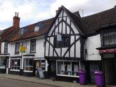
A 7th century document states that Hitchin was the centre of the Hicce people, ‘hicce’ being Old English for ‘the people of the horse’. By 1086, when the Domesday Book was compiled, Hitchin was described as a ‘Royal Manor’. The town’s name is also associated with the River Hiz (pronounced ‘hitch’ by some), a short stretch of which flows in front of the eastern end of the centrally located St Mary’s Church, which is mostly 15th century with an 11th century tower. Later, the town thrived because of the wool trade; vellum and parchment making; tanning; rope-making; malting; and its coaching inns, such as that mentioned in Heyer’s novel. Hitchin was a staging post for coaches travelling between London and what road signs in the south of England call ‘The North’. The town is not far from the current A1 trunk road. Many of the inns have long since closed, but their picturesque buildings, most of which look mediaeval, or at least pre-Georgian, still stand and can often be identified by the large archways leading from the street into yards behind them. Grain trading was another important activity in the town. Its former Corn Exchange still stands in the Market Square, but its use is no longer what it was built for.
Despite the 20th century improvements in transport links to London, making Hitchin into a convenient place for commuters, the historic town centre contains a remarkably high number of old buildings lining its mediaeval street lay-out. These old throughfares surround the lovely, large Market Square, which like many towns and cities in mainland Europe, was filled with tables and chairs for people to enjoy refreshments from the many eateries that surround it. A covered arcade leads off the square and provides a weather-proof place for refreshments. Nearby, there is a modern market area with stalls with conical roofs. We were fortunate to have arrived on a day, Tuesday, when this market is working.
Our first impression of Hitchin was extremely favourable, but because we had planned to do so much more sightseeing that day, we did not spend nearly enough time there. We hope to revisit this place again soon. I can strongly recommend the Hitchin to anyone who wants to get a flavour of ‘Ye Olde England’ without having to travel too far from London.
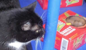
A furry feline
Finds box’d tamarind
But she has no need for it
DESPITE THE RAIN, we decided to walk along the path by the River Thames, proceeding upstream from Hammersmith. I had done this before, but never ventured beyond (i.e., upstream) the attractive church of St Nicholas, Chiswick, in whose graveyard you can find the funerary monument to the painter, William Hogarth (1697-1764), whose former home is nearby, and another to the Italian patriot, Ugo Foscolo (1778-1827). After walking along a riverside pathway that passes several recent, moderately attractive, but probably immoderately priced, housing estates, we reached Chiswick Pier at Corney Reach, whose name commemorates the now demolished Corney House, where Queen Elizabeth I was once entertained by the Earl of Bedford, who owned the place (www.chiswickw4.com/default.asp?section=info&page=conhistory29.htm).
Several lovely old houseboats are moored next to the pier. Near the jetty there is a noticeboard explaining the history of each of these vessels. Soon after this, the riverside path enters Dukes Meadow. Up to Barnes Bridge, which is a combined rail and pedestrian crossing over the river, the meadows form a grassy promenade running parallel to the Thames. Beyond the bridge, the meadows widen out and extend to Great Chertsey Road that crosses Chiswick Bridge.
The history of Dukes Meadow is recorded in a detailed essay by Gillian Clegg (https://brentfordandchiswicklhs.org.uk/dukes-meadows-the-threats-to-its-rural-survival/), from which I have extracted most of the following. In the past, the Meadow were low lying farmland and orchards prone to occasional flooding. The land was owned by the Dukes of Devonshire and cultivated by the Jessop family, then later farmed by John Smith of Grove Farm. Incidentally, one of the Dukes, William, the 5th Duke of Devonshire (1748-1811), who had owned nearby Chiswick House in the 18th century. He had both enlarged the house (in 1788) and extended its grounds. At one time, the grounds of Chiswick House must have neighboured the Dukes Meadow. Ms Clegg noted that it was miraculous that the meadows survived as such considering the plans that were proposed for making use of it during the early 20th century.
Two plans were conceived for the ‘development’ of Dukes Meadow. The first was a housing scheme that was to be named ‘Burlingwick’. Clegg wrote:
“On 19 April 1902 The Times newspaper reported that ‘an influential body of capitalists’ had negotiated successfully with the Duke of Devonshire for 330 acres of land for a building plan to be called Burlingwick. The promoter, manager and developer of this scheme was Jonathan Carr, the developer of Bedford Park.”
Had this gone ahead, it would have created housing for up to 400,000 people and 330 acres of green land would have been lost to bricks and mortar. Fortunately, for reasons that are not now too clear the scheme was abandoned in about 1906.
1914 saw the next threat to the Meadows. The Brentford Gas Company planned to cover 80 acres of the Meadow with a huge gasworks. The people of Chiswick and other areas raised strong objections. The London “Times” of 6th February 1914 published its doubts about the scheme, which it said went against all the principles of good town planning, suggesting:
“…that land ripe for building – such as the Chiswick orchard farm – near the heart of the metropolis should be utilized for parks and garden settlement.”
The plan was scrapped, but what the “Times” had alluded to was later realised, but in a then novel way.
In 1923, the local council bought 200 acres of land from the then Duke of Devonshire. The land was to be used as a public recreation area complete with a riverside promenade, a bandstand, and a children’s area with paddling pools. All of this cost the council much money. To recoup some of what they had spent, they made an agreement with the Riverside Sand and Ballast Group. As Ms Clegg explained, the company:
“…was allowed to extract at least five acres every year in exchange for £1,500 an acre.”
The extraction of gravel proceeded from 1924 until 1937 and caused considerable damage to the area. Ms Clegg explained that when the land was finally returned to the council in 1948:
“The gravel pits were filled in, mainly with rubbish brought from inner London, and the area re-landscaped. Dukes Meadows has been described as one of the earliest and most impressive examples of restoration.”
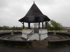
Today, the promenade remains but I saw neither a children’s play area nor paddling pools, which still exist. The bandstand, which stands within a sunken circle lined with steps on which the audience can sit has a hexagonal tiled roof supported by six plain pillars. It is flanked on two sides by spacious shelters, also with tiled roofs. All their roofs are designed so that the angle (or degree) of pitch reduces noticeably about two thirds of the way from the top. Judging by their appearance, I would guess that these structures were built back in the early 1920s. This is confirmed by their appearance in a photograph taken during those years. Also visible in this picture are the unusual, twisted railings, looking like sugar-candy, running alongside the water, and supported by concrete posts with rounded tops. These are still in place today as are their concrete supports which bear simple decorative patterns. Some balustrading can be seen lining the waterfront near the bandstand (see quote below).
Part of the promenade leading towards Barnes Bridge from the Chiswick end of the Meadow is arranged in the form of two long steps. I have no idea why, but maybe they were once used by spectators watching boat races on the river. An article written in 1924 describes the popularity the Meadow with people watching the annual university boat race (http://dmtrust.dukesmeadowspark.com/newriversidepleasaunce.html):
“…in fact so many thousands of people availed themselves of this vantage point last Saturday week at the small admission fee charged by the Council, that over £1,000 net was raised towards the promenade project.”
However, currently a line of bushes obscures sight of the river and the suburb of Barnes across it from these steps. A planning document produced in November 1923 (http://dmtrust.dukesmeadowspark.com/ariversideboulevard.html) sheds a little light on these steps:
“The Scheme, which received the first prize and was submitted by MR A. V. Elliot, of Chiswick, is reproduced on this page. It shows a series of terraces with a plateau of turf, showing seats and rustic shrubberies at intervals, and with a central feature of a bandstand and stone balustrading including a flight of steps and a causeway admitting to the river at all states of the tide.”
We enjoyed our stroll along the Dukes Meadow promenade even though the sky was grey, trees were dripping, and raindrops were falling intermittently. On our way back along the Thames Path to Hammersmith, we stopped at a charming Italian eatery and delicatessen on Chiswick Mall. The place, which is run by Sicilians, is called Mari Deli & Dining, and merits a visit to enjoy a good espresso, at the very least.
SIXTY-NINE YEARS ago on the 8th of May 1952, a lecturer in economics at the London School of Economics was sitting anxiously in the ante-chamber of an operating theatre in the Royal Free Hospital, which was at that time in London’s Grays Inn Road. It is now part of the Eastman Dental Hospital, the post-graduate dental school of University College London, where I have attended courses.

The lecturer looked up from what he was trying to read to distract himself when the gloved surgeon came out of the operating theatre, and talking to himself, but loud enough to be heard, said:
“Shall I use the Simpsons or the Kiellands?”
He was referring to forceps used to deliver babies. My father, who thought that the question had been addressed to him, replied:
“I am sorry I can’t help you with that. I am only an economist.”
The surgeon gave him a withering look, and returned to the operating theatre, where the economist’s wife was lying, deeply anaesthetised. In the end, the surgeon decided to deliver the baby with a Caesarian section.
That baby was me. The economist was my father. That I am writing this today is at the very least a minor miracle, as I will explain.
Back in the early 1950s, one did not argue with medical practitioners; they always knew best. My mother had informed her physician when I had been conceived, but he did not believe what she had said. I can imagine the doctor thinking: “what would she know? Only a woman.” So, when my mother did not give birth when she expected, at about nine months after conception, the doctor told her to be patient as he thought she had another month to go
After I had been ‘in utero’ for ten months, my mother began getting worryingly ill. Eventually, those who claimed to know best admitted her to hospital and I was delivered. Both my mother and me had developed symptoms of toxaemia. It was touch and go as to whether we would both survive, but we did.
Because I had been inside the womb for a month longer than I should have, I was born with several problems. One of these was a cerebral haematoma, which I hope has resolved itself by now. Years later, my mother told the school that I should not play rugby for fear of disturbing this. The other thing was that my neck was bent over to one side; I had a torticollis. The medics told my mother that it was incurable and that she should get used to the idea that I would just have to live with the distortion.
If I am not misrepresenting my late mother, I am certain that she would not have been happy living with a distorted child. She was a sculptor and decided that the doctors were wrong about being certain that my neck condition was incurable. Every day, she stretched my neck gently and gradually it began to grow in the normal way. I am incredibly grateful that she did this.
Getting back to my first days on earth, I had to spend the first fortnight in an incubator. In those far-off days, visiting babies in incubators was limited if it was allowed at all. My mother was exhausted after the traumatic birth and, given that she would not have been able to see me much whilst I was in the incubator, she and my father took a holiday in Cornwall. I only learnt about this a few years ago, Had I known about it when I was younger, who knows but I might have had a rejection complex. My behaviour might be considered unusual at times, but I feel it would be unfair to blame that on my spell in the incubator in London while my parents relaxed in Cornwall.
Well, there you have it: the story of the first few days of my life. Of course, I cannot remember any of it, but what I have told you was related to me by people who were around at the time.
THE PARISH CHURCH in Thaxted, Essex, which was built in the English Perpendicular Style between about 1380 and 1510, is at first sight simply an impressive, attractive, typical example of this era of church construction. Recently, we were able to enter it and the lady who showed us around revealed that this was no ordinary, ‘common or garden’ church. During the early 20th century, it had been home to activity that you might not expect in a building such as this.
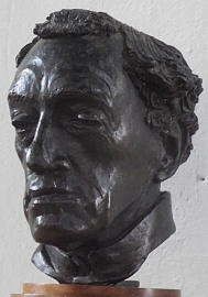
Within the church, there is a bronze sculpture by Gertrude Hermes (1901-1983). Mounted on a small wooden shelf, it depicts the head of Conrad Noel (1869-1942), who was the vicar at Thaxted from 1910 until his death.
Conrad was the grandson of the Earl of Gainsborough and son of Roden Noel (1834-1894), a Groom in the Privy Chamber, who left his exalted position after discovering radicalism. It was Roden who translated the words of “The Red Flag” into English. As a student at Cambridge, he had been a Cambridge Apostle. Conrad’s mother Alice (née de Broe) was daughter of a banker. Conrad was sent to school first at Wellington College and then at Cheltenham College. Then he entered Corpus Christi College Cambridge but failed to complete his course. After leaving Cambridge, he studied at Chichester Theological College, a high church Anglican establishment (https://en.wikipedia.org/wiki/Chichester_Theological_College). It was here that Conrad began to conceive his unique ideas about socialist Anglo-Catholicism. By 1893, he defined his theology as ‘Liberal Catholic’, which Edward Poole explained in “Troublesome Priests: Christianity and Marxism in the Church of England, 1906-1969”, his master’s thesis in 2014, was:
“…a theology that looks to the orthodox teaching of the Christian Church, that of Jesus and the Early Fathers, combined with a democratic approach to churchmanship and the active participation of the congregation in worship.”
At first, Conrad found it difficult to become ordained because of his radical, socialist ideas. In 1894, the Bishop of Chester ordained him, and he became a curate in Salford, where Poole related:
“Noel began giving lectures on Catholic Socialism which were boycotted by the ordinary congregation but … were successful in drawing in large numbers of working people who had never attended Church. The indignant Church Wardens referred the matter to Bishop Jayne, resulting in an acrimonious interview between Curate and Bishop. Jayne accused Noel of having no respect for the long-standing congregation, and of irreverence by encouraging attendees to ask questions about Christianity in Church. Noel reminded Jayne of Jesus’ invitation to ‘all and sundry’, but Jayne dismissed the argument.”
Conrad married Miriam Greenwood in 1894.
Jumping ahead, in 1910 the socialist cleric, Conrad, was appointed Vicar of the Parish Church in Thaxted. His appointment to this position was offered to him by a local aristocrat, a former mistress of King Edward VII, Frances Evelyn (‘Daisy Greville’), Countess of Warwick (1861-1938), who had become to quote Christopher Hibbert in his biography of Edward VII:
“… a dedicated socialist…” by 1906. Thaxted’s new vicar began revolutionising his parish almost as soon as he accepted the post. Mark Chapman, author of “Liturgy, Socialism, and Life” wrote that Conrad’s:
“…first great battle was over the bible boxes, which were used by the richer parishioners to reserve their places in church, and which deprived many of the poorer members of the congregation of the best seats.”
Actions such as these caused some of the wealthier members to leave the congregation, but this did not worry Conrad. He made many changes in the church and its liturgical practices in order to democratise his parish church. He wanted the church to be for all, for the common people, a recreation of the spirit of the earliest Christians. To do this, he introduced music and dancing and folkloric activities. John Millbank wrote in relation to this:
“The joy of Thaxted was a wise joy. The liturgy and the music and the dancing were as essential to Christian socialism as work amongst the poor” (quoted from Chapman).
Conrad had a strong disregard for the church hierarchy, who, on the whole, disapproved of his methods of helping people to believe they were an integral part of Christianity rather than only its recipients.
Socialism flowed through Conrad’s veins. In 1918, he set up the ‘Catholic Crusade’, which was a socialist movement that would:
“… work through the Church for a new economic society basing itself on the laws and principles of the gospels and the prophets. “(Chapman).
In addition, Conrad was strongly against imperialism, especially the British Empire, and also firmly in favour of reviving the Arts and Craft aspects of the socialism of William Morris and John Ruskin. The latter could be seen in many of the activities organised under his guidance at Thaxted.
Poole explains that Conrad’s socialism was based on Marxism and he was in favour of public ownership of the means of production, distribution, and exchange. His formation of the Catholic Crusade in 1918 followed the Bolshevik Revolution of 1917, which Poole notes:
“Noel saw the Revolutions… which brought the Bolsheviks to power, as evidence of a spiritual revival in Russia.”
Conrad hoped that a similar revolution would soon happen in the UK. Poole relates that later Conrad met Ivy Litvinov, wife of the Soviet Ambassador in London. She:
“…expressed to Noel surprise that a clergyman would celebrate the Bolsheviks despite their professed atheism. Noel responded that “dialectical materialism gave no true inspiration for the revolution, and that it was in spite of Marxist philosophy, rather than because of it, that those changes had taken place.”
Later when writing his autobiography, Conrad explained:
“I believe that the mystical element in the Russian people was much more the inspiration of the Russian Revolution than the appeal to the Marxian dialectic.”
By then, although still a socialist at heart, he was appalled by the Stalin-Trotsky split in about 1936 and he joined other clerics in the formation of the Anti-Stalinist Order of the Church Militant.
There is much more that could be discussed regarding Conrad’s idiosyncratic take on Socaialism and the Church, but I will concentrate on an incident that brought his church in Thaxted into the news in 1921. He had placed three flags in his chancel: the flag of St George, the tricolour of the Irish Sinn Fein, and the Red Flag of Communism. Students from Cambridge and also the ecclesiastical courts tried to remove them, but in vain. He preferred the flag of St George to the Union Jack, because the latter, he felt, ignored England and favoured plutocracy and British imperialism. As for the Irish flag, Chapman explained that it emphasised Conrad’s anti-colonialist ideals and the rights of national self-determination, for which WW1 had been fought. The Red Flag was chosen by Conrad because he felt that it:
“… was there to serve as a pointer to something more universal than a nation … it emphasised the notion of God as fellowship, and of the commonwealth and democracy of nations, none of which could be allowed to exist as an isolated entity…” (Chapman).
Poole noted:
“During the First World War, Noel displayed the flags of the Allies in Thaxted Church. After the Russian Revolutions, he added a plain red flag to represent the workers of the world, and by 1921, it hung with the cross of St. George and the Sinn Fein tricolour on the chancel arch, and on May Day that year it was paraded in the church. By the following morning it, and the tricolour, had been stolen by Cambridge University students, leading Noel to place a notice outside reading “Stolen! Two flags from Thaxted church and two universities (Oxford and Cambridge) from the people by the rich.””
The flags chosen by Conrad caused great strife (known as the ‘Battle of the Flags’) in Thaxted, as Poole describes:
“On 24 May, Empire Day, some residents hung the churchyard with Union flags, which Noel then replaced with ‘mutilated’ versions in which St Patrick’s cross had been removed. At a meeting at the Thaxted Guildhall, protestors demanded that Noel cease preaching political and seditious themes. A crowd gathered outside the Church, and fights broke out between them and former policemen defending the church. Noel’s friends called on him to leave Thaxted for his own safety, but he refused. After a night of unrest, Noel wrote to his wife to describe the excitement of the evening, and to reassure her that “the flags of our religion are still flying.” Further scuffles followed when protestors tried to remove a new flag on 20 June, and on 26 June when demonstrators successfully burnt the red flag and hung more Union flags in the church. In July the red flag was burnt again, but local moderates finally took control of the opposition to prevent further violence. In January 1922, a petition calling for the removal of the flags was sent to Chelmsford consistory court and Noel defended his right to fly the flags, but by July he was instructed to remove them, and complied.”
Many years later, when WW2 was declared, Conrad:
“…mused on the irony that the flag that had been so reviled by his parishioners was cheerfully displayed alongside the Union flag as Britain and the Soviet Union fought Nazi Germany. In his view, “the very people who opposed it are now grateful that the USSR is pulling our chestnuts out of the fire”” (Poole).
The only flag of note that we noticed during our visit to Thaxted’s church is a banner sewn in 1917 by Conrad’s wife Miriam. It bears some words of JS Bach that were chosen by the composer Gustav Holst who had a house in Thaxted (I will discuss Holt’s involvement with Thaxted in a future essay).
When visiting Thaxted and its lovely church, it is hard to imagine that the place was once the location of so much violence and controversy. I am glad to see that Thaxted’s highly original parish priest is remembered respectfully within his church. A plaque next to his sculpted head reads:
“Conrad Noel. Vicar of Thaxted 1910-1942. He loved justice and hated oppression.”
These are fitting words by which to remember an unusual man who espoused both Communism and Christianity, who saw no incompatibility between these two belief systems that many others believe to mutually opposed. To summarise, quoting Mark Chapman:
“… it seems to me that Noel was a genuine visionary, although his practical solutions may have neglected some or even most of the complexities or realpolitik, he nevertheless sought to make the church an expression of the kingdom of righteousness, justice, and equality and thus a beacon in a desperate world.”
