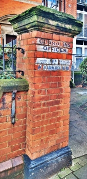
A church beside a canal in London’s Paddington

THE GRAND JUNCTION café is a peasant little place in a modern building a few feet away from the footpath that runs alongside the Paddington Arm of the Grand Union Canal, not far from Little Venice. This refreshment place is attached to a much older building, the church of St Mary Magdalene Paddington. It is a gem of Victorian gothic architecture. This is what I wrote about it in my book “Beyond Marylebone and Mayfair: Exploring West London”:

“[the church] … was designed by George Edmund Street (1824-1881), and completed in 1878. It was built in what was then an area with poor quality housing, where often several hard-up families used to live crowded together under a single roof. The parish in which it is located began life as an offshoot of All Saints in Margaret Street (near Oxford Circus). Like All Saints, St Mary Magdalene’s was established as an Anglo-Catholic church. Its website (grandjunction.org.uk) revealed that Anglo-Catholicism:

‘… emphasises the Catholic heritage and identity of the Church of England. In the mid-nineteenth century Anglo-Catholicism was very controversial and provoked riots. Anglo-Catholic churches were often built in very poor areas, and their clergy believed that their services, full of light, colour, music and ritual, were likely to appeal to the poor.

Like All Saints Margaret Street, the interior of St Mary Magdalene’s is a masterpiece of Victorian gothic extravaganza, a glorious riot of colour. The nave has a magnificent painted ceiling which includes faces of various saints. This was painted by Daniel Bell, a Victorian artist. Sculptures of saints carved by Thomas Earp (1823-1893) look down on the nave. The floor of the vast nave is decoratively tiled. Street did not believe in fixed pews such as are found in many other Victorian churches and were rented out to parishioners to raise money. He believed in ‘free seating’, especially in a church like St Mary Magdelene’s that was built to serve the poor. The apse is unusual in that it is polygonal, reminiscent of apses that the widely travelled Street had seen in mediaeval French and Flemish churches.

An unusual feature of this out of the ordinary church is that although the nave is flanked by a south and a north aisle, the latter is barely wide enough to accommodate one person, whereas the south one is almost as wide as the nave. The reason for the narrow north aisle was related to building regulations in force when the church was being constructed.”

We entered the church recently (in October 2025), after not having seen its interior since one quiet day in about 2021 during a respite in the covid19 lockdown regulations, and it looked as glorious as I remembered it. The church is still used for religious services and often as a centre for many local community events. Both the church and the café attached to it are well-worth visiting.

PS my book about west London is available from Amazon https://www.amazon.co.uk/BEYOND-MARYLEBONE-MAYFAIR-EXPLORING-LONDON/dp/B0B7CR679W/

Works of art flating on a canal near London’s Paddington

EVERY FEW WEEKS, we walk along the towpath of the Grand Union Canal (Paddington Arm) between the Meanwhile Garden in North Kensington and Little Venice near Paddington station. About 1/3 of the way along this route, we stop at the pleasant Grand Junction Café. Many canal narrow boats are moored alongside the towpath. Most of them are floating residences. Today, 31 August 2025, we spotted a narrow boat that we had not seen before. Moored between the Meanwhile Garden and the café, it is a floating, mobile art gallery.

Below the words “Canal Boat Contemporary” attached to the starboard side of the boat, there was a large glass-covered frame facing the towpath. This contained about 15 paintings. Next to the frame, there were notices giving information about the gallery’s concept and the works of the artist being displayed. There was also a whiteboard on which viewers could add their reactions to the art, using the marker pen attached to it. Between 27 August and 2 September, works by the artist Henrietta Roeder are on display.

Also attached to the boat and visible to passersby was the ‘manifesto’ of Canal Boat Contemporary, which can be read on a website (www.canalboatcontemporary.com). It refers to the ‘box’, by which they mean the display containing the art. Here are some excerpts from the manifesto to illustrate what the organisation is trying to achieve:

“Opera sings to chandeliers. If art wants to matter, it has to leave the palace … We moor up. We don’t ask for permission.We resist fixed power structures and take art to different places and contexts … We’re all speaking, nodding, showing – but always to each other. The Box is a window turned outward – away from the art world – for new eyes. It’s for someone walking their dog … The Box is modest, but powerful. A single painting on the towpath can shake you to the core … We don’t want your submissions. We want doppelgängers. Copy us. This idea wants to spread like moss. All you need is a frame no one’s using. A window everyone passes.”

Seeing the boat with its artworks, appearing as if from ‘out of the blue’ was a lovely experience. I think it is a wonderful idea to bring contemporary art outside of great institutions and commercial art galleries to make it available for anyone to stumble across unexpectedly.

Lloyd George on the railway tracks at Paddington station

IT IS NOT UNCOMMON to find that transport vehicles such as trains, boats, and aeroplanes, are given names. They are often named to honour noteworthy people. While strolling along platform 1 at London’s Paddington station today (21st July 2024), I noticed a train bearing the name ‘Megan Lloyd George CH’. You will, I hope, excuse my ignorance when I tell you that although I have heard of David Lloyd George (1863-1945), a former Prime Minister, Megan Lloyd George was not a name with which I am familiar. I wondered why the Great Western Railway (‘GWR’) had chosen to put her name on one of its trains. When I got home, I found out why.

Megan Lloyd George (1902-1966) was the youngest child of the Prime Minister David Lloyd George. She was born in Criccieth, Wales. Until she was four years old, she could only speak in Welsh. Between the ages of 8 and 20, she spent much of her life in the Prime Minister’s residence, 10 Downing Street. It is not surprising that the young lady became interested in politics. With some help from her father, Megan became the Liberal party candidate for the Welsh constituency of Anglesey, and in May 1929, she was elected as its Member of Parliament (‘MP’). She became the first woman MP from Wales. She was re-elected in the general elections of 1931 and 1935.

According to a biography (https://liberalhistory.org.uk/history/lloyd-george-megan/), Megan accompanied her father:

“… on his visit to Hitler in 1936, and opposed the policy of appeasement, urging him to press for Chamberlain’s resignation in May 1940.”

She served in Parliament throughout WW2, and was re-elected in 1945 and 1950, but with greatly reduced majorities. In 1952, she lost her seat.

For various political reasons, Megan and several other members of her party left the Liberal Party and joined the Labour Party in April 1955. In 1957, she became the Labour MP for Carmarthenshire, with a majority of 3000 votes. Always a popular figure, she took Carmarthenshire again in 1966, with a majority of 9000. By then, she was suffering from cancer, and died soon after the election and a few days after having been awarded the Companion of Honour (‘CH’) by Prime Minister Harold Wilson. In 2016, she was nominated as one of the ‘50 Greatest Welsh Men and Women of All Time’ (www.walesonline.co.uk/news/wales-news/50-greatest-welsh-men-women-11431779).

GWR trains run from Paddington to the west of England and parts of Wales including its capital, Cardiff. So, we should not be surprised to find Megan’s name on one of them. Having said that, I am not sure where the train with her name on it was heading as it left platform 1.

Taking the scenic route from St Pauls cathedral to Paddington

ONE AFTERNOON IN April (2024), out of curiosity we travelled by bus number 46 from Smithfield to Paddington station instead of taking the much faster Underground train route. As we proceeded along the whole route of the number 46 bus, we realised that it links several places of interest to both Londoners and visitors to the city.

The 46 starts within easy walking distance of the BARBICAN CENTRE, SMITHFIELD MARKET, ST BARTHOLOMEW THE GREAT, and THE LONDON MUSEUM. Also, its first stop outside ST BARTHOLOMEWS HOSPITAL is not far from ST PAULS CATHEDRAL.

When the bus gets moving, you will soon pass the ornate Victorian HOLBORN VIADUCT and HATTON GARDEN – famed for its diamond merchants. Next, you will see the Victorian gothic PRUDENTIAL BUILDING and before turning on to Grays Inn Road, you will see a row of half-timbered houses – some of the only PRE-FIRE OF LONDON survivors. Much of the west side of Greys Inn Road is lined with the buildings of GREYS INN – one of London’s four historic Inns of Court.

KINGS CROSS STATION and the magnificent Victorian gothic ST PANCRAS STATION are the next things to look out for. You could leave the bus here to explore the new developments around Kings Cross including COAL DROP YARD and KINGS PLACE hall and events centre. If you remain on the bus, you will head north past the ROYAL VETERINARY COLLEGE to the not over attractive KENTISH TOWN. At CAMDEN ROAD STATION, you will not be far from the REGENTS CANAL and the popular CAMDEN MARKET.

Heading northwards, the 46 reaches Fleet Road in south Hampstead, which is a short walk from the famous Modernist ISOKON BUILDING in Lawn Road. You could disembark at South End Green and visit Mirko to enjoy refreshments in his small MATCHBOX CAFÉ. HAMPSTEAD HEATH is a few minutes’ walk away. If you remain on the bus, you will pass the ROYAL FREE HOSPITAL and next to it, the Victorian gothic ST STEPHENS CHURCH designed by SS Teulon.

The bus then heads up Rosslyn Hill into the heart of historic HAMPSTEAD, where there is plenty for the visitor to explore. Then, the 46 descends the steep Fitzjohns Avenue to Swiss Cottage. Just before it reaches there, look out for the statue of SIGMUND FREUD at the southern end of the Tavistock Institute. The house where Freud lived, now THE FREUD MUSEUM, is close by.

After passing St Johns Wood Station with its several scraggly palm trees, the bus winds its way through streets near Maida Vale until it reaches Warwick Avenue Underground station. Descend here to walk to the REGENTS CANAL near to where it enters the scenic LITTLE VENICE.

Soon, after passing beneath the elevated WESTWAY, the 46 heads for its last stop, which is on a bridge from which you can get a good view of the wonderful glass and ironwork roof of PADDINGTON STATION – a masterpiece of Victorian engineering.  From Paddington, there are a few bus routes that will allow you to continue your London sightseeing.

When Kensington was a country town

ANYONE FAMILIAR WITH London will know that except for some parkland, the city is a built-up urban environment all the way west from Marble Arch to Acton and further beyond. This is also the case from Hyde Park Corner to Heathrow Airport. However, this has not always been the situation.

When John Rocque (1709-1762) drew his detailed, accurate maps of London in the 1740s, Paddington was a small village separated by open countryside from what was then London. In those days, Kensington was a village reached from London by a country road flanked on its northern edge by Hyde Park. And from Kensington to Hammersmith would have been a ride along a road running between a series of agricultural fields and orchards. And to the north of Hammesrsmith, Shepherds Bush was an open space around which there were only a few well-separated houses. And as for Notting Hill Gate, Rocque did not even bother to name this road junction in the middle of the countryside.

By 1826/27, when  C & J Greenwood published their detailed map of London, Earls Court was still a country hamlet; Kensington a small town; and there was barely any development around what is now Notting Hill Gate. However, by 1826 Paddington was beginning to grow and was no longer separated from Marylebone by open countryside. Additionally, the northern edge of the eastern end of Bayswater Road was losing its rural nature and being built upon.

In brief, as the 19th century progressed, London spread west. As it did so, urban development covered what had been open countryside and places that had been separated from London began to become part of it. Places like Kensington, Earls Court, Shepherds Bush, Hammersmith, and places further west were no longer separated by open countryside. Instead, they became engulfed by the expanding metropolis.

My book “BEYOND MARYLEBONE AND MAYFAIR: EXPLORING WEST LONDON” describes in detail how the villages and towns to the west of Park Lane and what is known as ‘The West End’ became engulfed by London’s westward growth. It reveals the history of these places; what they are like today; and what remains of their existence before they became joined to London, as it spread from Mayfair and Marylebone to Heathrow and beyond.

BEYOND MARYLEBONE AND MAYFAIR: EXPLORING WEST LONDON

By Adam Yamey

is available as an illustrated paperback and Kindle from Amazon:

Ukrainians from Canada

LONDON IS RICH in memorials. Some of them commemorate well-known figures and events and others make the observer aware of lesser-known aspects of history. One of these obscurer memorials is on number 218 Sussex Gardens, next to St James Church and not far from Paddington Station. It was placed on the building, which was rented by the Ukrainian Canadian Servicemen’s Association (UCSA) [Союз Українських Канадійських Вояків] in 1943.

According to an informative website (www.ukrainiansintheuk.info/eng/03/ucsa-e.htm), the UCSA was:
“…formed on 7 January 1943 in Manchester, to cater for the social and cultural needs of Ukrainian Canadians serving overseas. Initially the association had 37 members. By the end of the war there were 1,500 active members and over 3,000 additional names on the association’s mailing list.”
That is clear enough, but I wondered about the story of the Ukrainian Canadians. In 2016, there were more than 1.4 million Canadians with Ukrainian ancestry. Canada has the third largest population of Ukrainians after Russia and Ukraine. Almost certainly, 1891 marked the start of the migration of significant numbers of Ukrainians to Canada. Back in those days, the territory, which is now the republic of Ukraine was divided between the Austro-Hungarian and Russian Empires. They were welcomed in Canada as the country needed workers to populate and cultivate the prairies.

The UCSA occupied the house in Sussex Gardens from late 1943 until early 1946. The website quoted above revealed that the UCSA:
“… organised social gatherings, or “get-togethers”, for its members, initially in Manchester and later also in London. A choir and a dance orchestra were organised at the London club, and a library and reading room were maintained there. The association’s activities also included visiting sick and wounded Ukrainian Canadians, compiling lists of those who had died or were taken prisoner, and looking after the graves of the dead (at various cemeteries in the UK, including Brookwood Military Cemetery near Woking, Surrey). From September 1943 the association published an UCSA Newsletter.”
As WW2 drew to a close, the UCSA also provided assistance to Ukrainian displaced persons and refugees from mainland Europe.

The memorial plaque on 218 Sussex Gardens was placed in September 1995, long before Russia began its current conflict with Ukraine. Unlike the statue of the Ukrainian Saint Volodmyr, which stands in Holland Park Avenue, the building near Paddington did not have any pro-Ukraine flags or other patriotic items affixed to it. The plaque is a discrete memorial to an aspect of the history of WW2, about which I knew nothing until today.

Exotic vegetables and a building in Paddington

EXOTIC VEGETABLES AND PADDINGTON STATION

CRAWFORD MARKET IN central Mumbai was completed in 1869. Its British architect William Emerson (1823-1924) designed it in an Indo-Saracenic style, which attempted to combine Victorian Gothic and Indian architectural features.

Crawford Market

I am familiar with some of Emerson’s other buildings. One of them is the Nilambagh Palace in Bhavnagar, Gujarat. Now a hotel, we have stayed there. Another building, which is closer to our home in London, is the Clarence Wing of the St Mary’s Hospital in London’s Paddington. You can read more about the hospital in my book “BEYOND MARYLEBONE AND MAYFAIR: EXPLORING WEST LONDON”, which is available from Amazon.

Two of the entrances to the market hall are surmounted by lovely bas-reliefs, which were created by Rudyard Kipling”s father John Lockwood Kipling (1837-1911). The building was the first in India to be lit by electricity. This was added in 1882. There is a noteworthy Gothic revival drinking fountain in the market hall. This was gifted by Cowasji Jehangir. Many cats and kittens were running around its base. No doubt at night, they threaten the rodents that might be lurking around the market. During the day, they are given tidbits by the market traders.

The market is mainly for food and household goods. When driving past it on the nearby JJ Flyover, there is usually a whiff of fish emanating from it. However, within the market, this is not noticeable.

Amongst the numerous vegetable stalls, we noticed a few selling typical European products such as lollo rosso lettuce, fresh basil leaves, and other herbs associated more with European cuisine than Indian. At one of these stalls, we spotted Chinese cabbage and pak choi. The stalls selling these described themselves as purveyors of “exotic” or “English” vegetables.

A visit to Crawford Market is always worthwhile. You are likely to be approached by porters who will offer to follow you around whilst you shop. They will carry your shopping in cylindrical baskets, which they balance on their heads. As we were ‘just looking’, we did not take up their offers.

I have been gongoozling at London’s Little Venice today

I HAVE LEARNED a new word today. It can be used as both a noun and as a verb. The noun is ‘gongoozler’ and the verb is ‘to gongoozle’. I came across it used as a verb on an information panel by the south side of the water basin at Paddington’s Little Venice, where the Paddington Arm of the Grand Union Canal enlarges to become a pond, from which the Regents Canal commences.

The word gongoozle might possibly derive from two words of Lincolnshire dialect: ‘gawn’ and ‘gooze’. Both these words mean to stare or gape. A ‘gawn’ can also mean a small freight-carrying boat such as a canal narrowboat.

Gongoozling usually refers to watching boats. And this is what we did today as we ambled lazily along the Paddington Arm and the shore of Little Venice. With the sun shining and a pleasant air temperature (about 21 degrees Celsius), this was an enjoyable way of passing time on a Sunday morning.

The West End is no longer the west end

LONDON’S WEST END includes the part of the city that contains areas such as Chinatown, Theatreland, Covent Garden, Leicester Square, Oxford Street, Mayfair, Soho, Fitrovia, and Bond Street. Before the 19th century, the western boundary of London was Park Lane, which runs along the west edge of the West End.

The west edge of London in about 1809: the dashed line that runs from north to south runs along Edgware Road and Park Lane. West of this libe was Hyde Park and open fields

Until the end of the 18th century and even during the early years of the 19th, west of Park Lane and the West End was the Middlesex countryside, which was dotted with villages such as (for example) Paddington, Kensington, Chelsea, Hammersmith, Fulham, Acton, Ealing, and Southall. In between these then separated places there were farms, heathlands, parks, stately homes (such as Chiswick House and Osterley Park), and highwaymen.

During the 19th century, several things happened. London expanded in all directions and spread into what had been countryside. The small villages in Middlesex grew in size. Some of them coalesced. Canals and railways were built, and along with them, building in areas that had previously been rural, caused them to become urban. In brief, London spread relentlessly westward. What was called the West End, and is still so-called today, was no longer the west end of the city of London.

Although many previously rustic settlements (such as Paddington and other places mentioned above) became engulfed in the metropolis, most of them have retained at least a few reminders of their pre-urban past. Currently, I am putting the finishing touches on a book about London west of the West End. In it, I hope to help readers discover more about London’s western spread and what has survived it (despite being surrounded by the city’s western expansion).

Mismatched signals

HOW RIDICULOUS IS THIS?

The newly opened Elizabeth Line is supposed to link east and west London. However if you wish to travel from a station east of Paddington to one west of it (or vice-versa), you have to change trains at Paddington. This is far from simple. The section of the line that runs west from Paddington is on one side of Paddington mainline station, and the section that runs east is far across the mainline station concourse at a lower level.

Platform lighting at Paddington Station (Elizabeth Line)

Today, I asked an official whether the east and west branches of the Elizabeth line will ever be connected, so as not to need to change trains at Paddington. He said that the infrastructure (tracks etc) are already in place, but there is a problem that still needs to be solved. The problem is that the signalling system on the western part of the line is completely different from that on the eastern part. Surely, someone could have solved this problem during the many years it has taken to construct the Elizabeth Line(s)?