HADRIANS WALL WAS constructed by the Romans in about 122 AD. Its purpose was to separate Roman Britain to the south of it from the ‘barbarians’ who lived north of it. Before it was built, they built a fort at a point where Dere Street, a major Roman road that ran in a north-south direction met Stane Road, a road that before the construction of Hadrian’s Wall marked the northernmost boundary of Roman Britain. This fort, established in the 80s AD, was called Coria, for short, and its full name might have been Corstopitum or Corie Lopocarium or, even, Coriosopitum, Corsopitum or Corsobetum. The site where they built the fort is near the town of Corbridge in Northumberland. Archaeological evidence suggests that the site of Coria had been occupied in the Iron Age, long before the Romans arrived.
After the construction of Hadrian’s Wall and its forts, Coria ceased to be a military centre, and began to be developed as a Roman town for civilians. It is believed from archaeological investigations that the town had temples, granaries, a fountain house, and a civic forum. Additionally, the place had residential buildings, both grand and modest. The town served as a supply centre for the military as well as being a market place for the lead, iron, and coal mined in the neighbourhood. After the Romans left Britain, their town fell into decline. Nearby Corbridge was founded by the Anglo-Saxons sometime after the Romans had cleared out of England.
It was not until 1861 that the first excavations that revealed remains of the town were discovered by Mr Coulson. Between 1906 and 1914, more extensive archaeological work was carried out by Francis J Haverfield (1860-1919) and Leonard Woolley (1880-1960). After working at Coria, Woolley travelled to the Middle East, where his excavations in Mesopotamia were to make him famous. Later, the site of the Roman town became Britain’s first training site for young archaeologists.
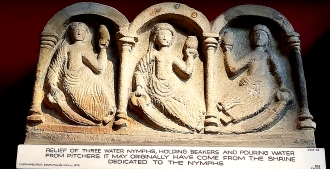
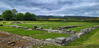
Today, the remains of the town, mostly stonework, are in the care of English Heritage. The site is well-cared for and labelled with useful information panels, without which one might have little idea about the nature of what one can see. Next to the sight, there is a small museum filled with beautiful artefacts found in and near the town. Most of them are stone carvings, and all of them are well displayed. Whereas a visit to Coria does not give one as much of an impression of Roman architecture, as does, say Ostia near Rome, it is a pleasant place to visit and quite thrilling to consider that you are in what was once the northermost part of the Roman Empire.