Holy smoke by the River Thames

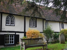
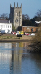
THE TOWER CAN BE seen from far away. From a distance, the visitor to Old Isleworth on the River Thames might be fooled into believing that the 14th century stone square church tower topped with four pinnacles, one at each corner, is attached to an equally venerable church, but this is no longer the case. The mediaeval tower is almost all that remains of the mediaeval church of All Saints in Isleworth. It is attached to a twentieth century structure that now serves as the church. When I saw this, I wondered what disaster had befallen the rest of the original pre-20th century church.

The origin of the name Isleworth is unknown. In the Domesday Book, it is listed as ‘Gistelworde’ and Norden, writing in 1591, named it both ‘Thistleworth’ and ‘Istleworth’. Simon de Montfort (c1205-1265), who expelled the Jews from Leicester in 1231, and his barons are known to have camped in Isleworth Park in 1263. To digress, maybe, in view of his anti-Semitism, the authorities of De Montfort University in Leicester, ought to reconsider its name. Getting back to Isleworth, the Domesday Book records that there was Christian worship in Isleworth (https://allsaints-isleworth.org/about-us/church-history/) and a vicarage is mentioned in records compiled in 1290 (www.british-history.ac.uk/vch/middx/vol3/pp122-129). The church, whose tower is still standing, was dedicated to ‘All saints’ in 1485 and was connected to Syon Abbey, a Bridgettine establishment, founded in 1415 in Isleworth, which was disbanded by Henry VIII. Interestingly, it was in the Abbey’s chapel that the body of Henry VIII lay overnight on its journey from Westminster to St Georges Chapel in Windsor (https://en.wikipedia.org/wiki/Syon_Abbey). The abbey stood where Syon House stands today.

The church is said to have been ‘very ancient’. Its chancel was rebuilt in 1398-99. By 1701, the church was in a poor condition and needed rebuilding. Christopher Wren, architect of London’s St Paul’s Cathedral, was invited to redesign the church. His design was deemed to costly to be carried out and was discarded. Eventually, the churchwardens brought out Wren’s plans and modified them to make the construction of the church more economical. James Thorne, author of “Handbook to the Environs of London” (published 1876), wrote that:

“Apart from its ivy-covered tower, there could not well have been an uglier ch[urch] than that of Isleworth a few years ago…”

However, he added:

“…but it has been transformed, the windows altered, a new roof of higher pitch, and a lofty white-brick Dec. [i.e. gothic revival] chancel added, greatly to the benefit of the general effect.”

He also described many improvements to its interior and noted the existence of a fine organ built by Father Schmidt (Bernard Schmidt: c1630-1708). Alas, none of what Thorne described, apart from the tower, can ever be seen again.

Except for the tower, the church was destroyed by fire in 1943 during WW2. The fire was not the result of military activity but was caused by two young boys. These same two miscreants also set fire to Holy Trinity Church in Hounslow a few days later. This is what happened (https://stmargarets.london/archives/2013/05/fire_starter.html):

“In the early hours of Friday, 28th May 1943, All Saints Church, standing by the Thames in Old Isleworth, was destroyed by fire. The alarm was given at 2.30am by Miss Burrage who lived next door and again by Mr. McDonald, the publican of the “London Apprentice”. Against the darkness of the wartime black-out the glow of the huge fire could be seen for miles.

Three days later, on the afternoon of Tuesday 1st of June 1943, the Parish Church of Hounslow (Holy Trinity) was completely destroyed by fire. Shortly after 5.00pm smoke was reported to be issuing from the church … The police noted that an attempt had been made to open the church safe…”

Two boys, one aged 12 and the other 13, were arrested and tried at Brentford in the old courthouse, which is now home to a restaurant/café called The Verdict. These two youngsters had been in court several times before for crimes of petty theft. In court, they admitted:

“…that they only set fire to the churches out of spite and only if they found no money to steal. They told the chairman Mr. A. J. Chard J.P, how easy it was to break into churches and how easy it was to burn them down. At the Mission Hall they set fire to the curtains. At Broadway Baptist Church they set eight separate fires. At Holy Trinity it was five. The older boy also confessed to burning down a haystack in a coal yard a year earlier.”

The two arsonists were sent to approved schools. The Chairman of the Court recommended:

“…to the Home Office that the two lads should go to separate schools and that the schools should be of the strictest kind; further, that they should be kept there for the full period of three years.”

All Saints Church was rebuilt yet again in 1970 to the designs of architect Michael Blee (1931-1996), who built several churches. From the outside it is quite an attractive structure attached to the mediaeval tower.

While wandering around the church, two things caught my eye. One is a stone placed close to a large yew tree in the churchyard. The stone informs us that the yew tree is growing upon the site where 49 people, who died in the Great Plague of 1665, were buried.  The other feature that interested me was a group of stones set in the wall surrounding the churchyard. Each of these records the level to which water reached when the Thames flooded on various years between 1774 and 1965. The building of The Thames Barrier, completed in 1984, brought an end to these flooding events.  

All Saints Church stands a few yards away from the riverbank from where there are wonderful views of the Thames and Isleworth Ait and a rich selection of waterfowl swimming in the river. Given how close the old part of Isleworth is to suburban west London, it has a remarkably rustic feeling, and is a peaceful place, providing you ignore the low-flying aircraft that pass above every few minutes.

A socialist by the River Thames

ISLEWORTH IN WEST London was until this month, March 2021, a place where I had never before set foot. A road direction sign with the words “Historic Isleworth Waterfront” tempted us to investigate the place and we found it to be a delightful location despite it being under a flight path for aeroplanes coming into land at nearby Heathrow Airport. After enjoying the view across the River Thames from Old Isleworth, my eye alighted on a house with a circular memorial plaque placed to remember someone significant of whom I had never heard.

Arthur Joseph Penty (1875-1937) lived at 59 Church Street in Isleworth between 1926 and his death. The commemorative plaque bears the words:

“Architect and pioneer of Guild Socialism”

Penty was born in York, eldest of the two sons of the architect Walter Green Penty (1852-1902) of York. Arthur first worked in his father’s architectural practice before moving to London in 1902, where he increased his involvement in the Arts and Crafts Movement. Shortly before his move, he met Alfred Richard Orage (1873-1934). He was an influential British socialist and a Theosophist. He edited a journal called “The New Age”, which was inspired by Fabian Socialism (https://en.wikipedia.org/wiki/The_New_Age).

Old Isleworth

In London, Penty collaborated with the architect Raymond Unwin, who was responsible for much of the planning and design of Hampstead Garden Suburb, whose construction began in about 1904. Penty, working in Unwin’s office, is believed to have designed some of the details of two large buildings, Temple Fortune House and Arcade House, in Temple Fortune, as well as aspects of the so-called ‘Great Wall’ that separates part of the Suburb from the northern edge of Hampstead Heath Extension (www.hgs.org.uk/tour/tour00045000.html).

Apart from architecture, Penty was an important exponent of Guild Socialism. Many of his thoughts on the subject were published in Orage’s “The New Age”. I had never heard of Guild Socialism before seeing Penty’s house in Isleworth. Let me see if I can make any sense of this now long-outdated form of socialism, whose ideas were influenced by the great designer William Morris (1834-1896) and his associates. Guild Socialism opposed capitalism. According to Encyclopaedia Britannica (www.britannica.com/event/Guild-Socialism), Guild Socialism is:

“…a movement that called for workers’ control of industry through a system of national guilds operating in an implied contractual relationship with the public.”

It began in 1906 with the publication of “The Restoration of the Gild System”, written by Penty. The Guild Socialists believed that industry should be owned by the state but controlled by workers through national guilds organised by their members democratically. The system proposed was a kind of nostalgic revival of the mediaeval guild system. During WW1, Guild Socialism was enhanced by the actions of left-wing shop stewards demanding ‘workers’ control’ of the war industries. The movement declined with the onset of the economic slump of 1921 and the subsequent policies of both the Labour and Socialist Parties in Great Britain.  

As Penty neared the end of his life, he became attracted to the ideas of Fascism that were prevalent in the Europe of the 1930s. The Oxford Dictionary of National Biography (www.oxforddnb.com/view/10.1093/ref:odnb/9780198614128.001.0001/odnb-9780198614128-e-53509?rskey=IABIgM&result=1) reveals that by the early 1930s, Penty:

“… was attracted to the anti-modernism of the far right. He admired the corporatist* economic organization of Mussolini’s Italy, supported the nationalists in the Spanish Civil War, and interested himself in the ideas of Oswald Mosley. At the same time he denounced Italian imperialism in Abyssinia and rejected Nazism for its racial doctrines and its statism.”

Penty, who dedicated his life to the revival of mediaeval craftsmanship and guilds, died at 59 Church Street in Old Isleworth on the 19th of January 1937. This late 18th century building bears the name “Manor House”. According to one source (http://edithsstreets.blogspot.com/2016/10/riverside-north-of-river-and-west-of_12.html), this is neither the manor house nor is it on the site of the real manor house. It was bought by Michael Penty, who also bought the manor of Isleworth. Michael’s father was Arthur Penty (http://www.panoramaofthethames.com/pott/isleworth-2006/59-church-street-isleworth). His name is on the front door, along with a brass plate bearing the words:

“MICHAEL PENTY Solicitor & Commissioner for Oaths

LORD OF THE MANOR OF ISLEWORTH RECTORY”

Had it been open, we would have enjoyed a drink at the riverside pub, “The London Apprentice”, which is a few steps away from the house where Arthur Penty once lived, but it was closed. However, a short walk away across the Duke of Northumberland’s River, we found a small café called South Street that served beverages and locally made ice-cream to take away.

*Note:

“Corporatism is a political ideology which advocates the organization of society by corporate groups, such as agricultural, labour, military, scientific, or guild associations, on the basis of their common interests.” (https://en.wikipedia.org/wiki/Corporatism).

Where Londoners once had fun

BEFORE THE COVID19 PANDEMIC gripped the world, many Londoners made outings to pleasure grounds such as Legoland, Thorpe Park, and further afield to Disneyland near Paris. During the late 18th century, Londoners seeking entertainment headed for places such as Vauxhall Gardens, Ranelagh (now, the grounds of Royal Hospital Chelsea, site of the Chelsea Flower Show), and Cuper’s (across the Thames opposite Somerset House). These pleasure gardens began to decline, some before and others during the 19th century. However, in their wake, another such place came into existence in Chelsea, Cremorne Gardens.

Thomas Dawson, 1st Viscount Cremorne (1725-1813), an Irish landowner, possessed a plot of land on the north side of the Thames, just west of Battersea Bridge. There he had a mansion, Chelsea Farm, which was often visited by King George III, his wife Queen Charlotte, and the future George IV. In 1825, the property came into the possession of Granville Penn (1761-1844), a cousin of Cremorne’s widow.  Penn’s claim to fame is that he was involved in the establishment of what is now The Royal Veterinary College in London (www.rvc.ac.uk/about/the-rvc/history). Penn did much to improve the grounds of the estate, but later sold it. The house and grounds were bought in 1831 by Charles Random De Berenger, Baron De Beaufain (www.rbkc.gov.uk/leisure-and-culture/parks/), who created the Cremorne Pleasure Gardens.

The great beauty of the grounds led it to being opened by De Berenger as a public pleasure ground known at first as ‘The Stadium’. De Berenger was:

“… a sportsman and in the grounds opened Cremorne Stadium. Members who paid their two or three guineas could, under the Baron’s instruction, shoot, box, and practise “manly exercises generally” in the grounds.” (https://www.rbkc.gov.uk/pdf/CRA_Historical_Survey.pdf).

Today, there is a Stadium Street located in what would have once been part of Cremorne’s estate.

The Baron died in 1845 and the estate grounds were sold. They were laid out tastefully and the place, opened as a public pleasure ground that attracted large crowds of people seeking pleasure and entertainment, who were willing to pay modest fees for it. The gardens flourished between 1845 and 1877. In 1850, they came under the ownership of Thomas Bartlett Simpson, who also purchased Ashburnham House (an 18th century edifice) on the west side of the estate, which he used to house some of his visitor attractions. The grounds offered visitors many attractions including dancing; meals; secluded areas; firework displays; theatres for farce and vaudeville; ballets; puppet shows; trapeze artists; tight-rope walkers; a maze; and balloon ascents.

In his 1880’s “Old and New London”, Edward Walford describes some of the exploits with balloons, which were not without excitement. In 1839, whilst the gardens were owned by De Berenger, a Mr Hampton equipped with a parachute ascended two miles above the ground with a balloon and then descended to the ground with his parachute.  Some years later, Vincent De Groof ascended from Cremorne Gardens in a contraption, designed to help him fly, suspended from a balloon. After reaching a high altitude, something went wrong and poor De Groof fell to his death.

By the 1870s, the Cremorne Gardens were becoming disreputable, especially becoming notorious for prostitution. After they closed (for financial reasons), the land became used for building houses and other buildings including the Lots Road Power Station.

In about 1846, the artist JMW Turner (1775-1851) moved into a house by the river on what is now Cremorne Road, close to Cremorne Gardens and to the Cremorne Pier. He constructed a kind of gallery on its roof, from which he could sit and observe the changing light on the river. According to a biography by Peter Ackroyd, Turner was unwell whilst he lived there, suffering from dental problems that caused him to lose all of his teeth, and consequent dietary-related illness. He remained in Cremorne Road until the last year of his life and died there.

Today, little remains of Cremorne Gardens except a few street names and a small park close named Cremorne Gardens next to the river. This delightful, small open space has a paved section as well as a lawn. It is a tiny fragment of the original Cremorne Gardens but a fitting memorial to a place that provided entertainment for Londoners over many years. A couple of piers project into the river. These were originally landing stages for visitors arriving at the Gardens by river boat. Another souvenir of the heyday of the Gardens is a pair of wrought iron gates that stand in the present plot, but not in their original position, now built over. Small though it is, with its superb views of the Thames, the present Cremorne Gardens is a pleasant place to visit, within a short distance from the fashionable Kings Road.

Where there are dolphins

I HAVE NEVER VISITED MOSCOW, but I imagine that the huge, rather forbidding looking apartment block on Grosvenor Road facing the River Thames, would not look out of place in the Russian city. Covering seven and a half acres of land, built with twelve million bricks and almost seven thousand external window units, and containing at least twelve hundred flats, this mammoth building complex, which has been home to many of the famous and infamous, was completed in late 1936. This enormous residential complex is called Dolphin Square.

Maps surveyed in 1869 and 1913 reveal that the land on which Dolphin Square was built, which is west of St Georges Square, used to be the site of the several long buildings that together made up the Royal Army Clothing Department and its storage depots. Before that, the land was occupied by the work premises of the developer and builder Thomas Cubitt (1788-1855), who built much of Belgravia and Pimlico. A few years after his death, the army leased the site and the depot stood there until 1933, when the lease reverted to the Duke of Westminster (https://en.wikipedia.org/wiki/Royal_Army_Clothing_Depot).

An American firm, Fred F French Companies, bought the freehold of the former army clothing compound, and then, discovering it had insufficient funds to develop it, sold it on to Richard Costain Ltd. Costain commissioned the architect Stanley Gordon Jeeves (1888-1964), whose other works include the now demolished Earls Court Exhibition Centre and the still standing large, art-deco Latimer Court at Hammersmith, to design the residential complex that exists today. Writing soon after it opened, the writer AP Herbert (1890-1971) wrote a book extolling the virtues of Dolphin Square. He wrote that it is:

“…a city of 1,250 flats, each enjoying at the same time most of the advantages of the separate house and the big communal dwelling place …”

Commenting on the fact that the complex included a restaurant, he wrote:

“…fortunate wives will not have enough to do. A little drudgery is good for wives, perhaps. The Dolphin lady may be spoiled.” (quotes from www.theundergroundmap.com/article.html?id=2792)

From outside the building, Dolphin Square looks monolithic and forbidding. However, on entering the huge courtyard within it, this impression changes. For, the courtyard contains a lovely garden, which was designed by Robert Sudell in about 1937 (https://historicengland.org.uk/listing/the-list/list-entry/1455668). Though much modified since then, the formal garden retains much of the original design concept including an axial avenue lined with chestnut trees. Appropriately, the middle of the garden is adorned with a fountain with three sculpted dolphins. Created by the sculptor James Butler (born 1931), this was placed in 1987 to replace an earlier fountain. This pleasant garden would be one good reason to entice me to live in this extraordinarily massive complex. 

As mentioned already, Dolphin Square offers its residents a restaurant. It also contains an arcade of shops, a café, a gymnasium, a swimming pool, a laundrette, underground parking, a bar, a brasserie, a hotel, a tennis court, and more. And all of this is within a short walk of Westminster and the Houses of Parliament. This proximity to the centre of government means that many MPs have made use of Dolphin Square as their London ‘pads’.

Apart from politicians, including Harold Wilson, William Hague, David Steele, and many others, Dolphin Square has been home to people of fame and notoriety. According to an article in Wikipedia, some of these include Oswald Mosley and his wife Diana Mitford; the novelist Radclyffe Hall; Christine Keeler and Mandy Rice-Davies; the comedian Bud Flanagan; the spy John Vassall; and the tennis player Rod Laver. Princess Anne lived in Dolphin Square briefly in 1993, General de Gaulle based his Free French Government in part of the Square in WW2, and Sarah, daughter of Sir Winston Churchill, was:

“…evicted from the square for hurling gin bottles out of her window.” (https://www.bbc.co.uk/news/magazine-33785352).

It seems that a fascinating book about the residents of Dolphin Square is waiting to be written.

I had passed Dolphin Square plenty of times before entering its garden recently, but until now I had no idea that this far from attractive building was home to such a fascinating range of people nor that it contained such a fine garden. Just as one should not judge a book by its cover, it is a mistake to judge Dolphin Square from its exterior.

Honouring a Hindu hero in London

MI5 WORKS TO HELP protect our democracy in the UK. Its architecturally unflattering headquarters stand looming above the southern end of Vauxhall Bridge. A few yards downstream from it, and directly facing the main entrance of the Tate Britain across the river, there is a small grassy triangle close to the river. In the middle of the green space, there is a bust on a pedestal. The bust depicts a man with a moustache, who is wearing two chunky necklaces and what looks like a bejewelled turban. This is a monument to Basaveshvara, who lived between 1134 and 1168 (actually, these dates are not certain: he might have lived c1106-1167). A panel on the side of the pedestal notes that he was:

“Pioneer of Democracy and Social Reform”

Various people and organisations supported the creation of this monument to someone of historical importance but until now unknown to me and, I would guess, to many other people wandering past the bust. As one of the organisations involved in its creation was The Government of Karnataka (in southern India), I reached for my tattered copy of “A History of Karnataka” (edited by PB Desai), which I picked up in the wonderful Aladdin’s cave of a bookshop, Bookworm, in Church Street, Bangalore, a city which I visit often. It has 8 index entries for Basaveshwara, who is also known as ‘Basava’, ‘Basavanna’, and ‘Basavaraja’, all of these being transcripts from various Indian language alphabets.

Basaveshwar was born of Shaivite Brahmin parents at Bagevadi, which is now in the Bijapur district in the northern part of Karnataka. His name is derived from the Sanskrit word ‘Vrishabha’, the divine bull, Nandi, who carries the god Shiva. Early histories (the Puranas) described him as an incarnation of the god Shiva rather than a human being, but it is considered that he was certainly a real person. A devotee of Shiva, Basaveshwara was well-versed in both Kannada and Sanskrit learning. He was brought up in a social milieu in which people blindly adhered to the dogmas and rituals of Vedic Hinduism without bothering to understand the true spirit of religion. Desai wrote:

“Basava’s mind revolted against these ills and he decided to defy the existing order of things.”

After receiving the sacred thread, very roughly speaking a Hindu equivalent of the Jewish Bar-mitzvah or the Christian confirmation, Basaveshwara went to the Kudama Sangama, a temple complex at the confluence of the Rivers Krishna and Malaprabha. In 2011, long before I had ever heard of Basaveshwara, we stopped briefly at the Sangama on our way from Hospet to Bijapur (now named ‘Vijayapura’), both in Karnataka. When we were there, the rivers had dried up and we saw signs advising visitors to beware of crocodiles.  

Basaveshwara remained at the Sangama for about 12 years. In his time, as it is now, the Sangama was much visited by people from all walks of life. There, he met many scholars and learned men from all schools of Hindu belief. Eventually, Basaveshwara travelled to Mangalavada, the headquarters of Bijala II (c1130-c1167), the feudatory governor of the Kalachuri family (of the Chalukya dynasty). Soon, Basaveshwara became the Chief Treasurer of Bijala’s court. It was then that Basaveshwara:

“… started his new movement of religious and social reforms, treating all devotees of Siva [i.e. Shiva] as equal in all respects without the traditional distinctions of castes, communities and sects.” (Desai)

After about 20 years, BASAVESHWARA moved to Kalyana, the capital of Bijala, where his reformist ideas gained a great following. Bijala II, who had become suspicious of Basaveshwara, began crushing the movement inspired by Basaveshwara’s radical ideas that seriously threatened the traditional hierarchy that favoured the Brahmins, as well as advocating some hitherto unknown equality of men and women in spiritual aspects of life. For example, Basaveshwara sanctioned a marriage between the son of an ‘untouchable’ and the daughter of a Brahmin. Upset by this, Bijala sentenced the couple to death. Basaveshwara’s followers then plotted to assassinate Bijala, an act of which Basaveshwara disapproved. Realising that he could not restrain his angry followers, Basaveshwara retreated to Kudama Sangama, where he died. Bijala was murdered soon afterwards. Later, Basaveshwara became venerated as a (Hindu) saint.

Basaveshwara believed:

“…that every human being was equal, irrespective of caste and that all forms of manual labor was equally important.” (https://en.wikipedia.org/wiki/Basava).

These ideas sound familiar to those versed in the history of Mahatma Gandhi, who lived many centuries after Basaveshwara.  Yet, Basaveshwara is relatively unknown compared with Gandhi. Basaveshwara was certainly a reformer as is stated on the base of his bust near Vauxhall Bridge and his radical ideas were undoubtedly democratic when considered in relation to the time when he lived. So, it is quite appropriate that from his bust, there is a clear view of the Houses of Parliament, a home of democracy.

The bust on the embankment was erected by Dr Neeraj Patil, born in Karnataka, a member of the Labour Party and Mayor of the London Borough of Lambeth 2010-2011 and Dr Anagha Patil. It was unveiled in November 2015 by the current Prime Minister of India, Shri Narendra Modi. It is appropriate that Modi inaugurated this memorial as his parents were members of what was officially recognised a socially disadvantaged community, whose emancipation would surely have been approved by the reformer Basaveshwara.  And what is more, Modi is one of the first, if not the very first, of the Indian Prime Ministers, all democratically elected, who was not from a ‘high’ caste or social class such as Brahmin, Kayastha, and Rajput, and has completed at least one term of office. So, I feel that Basaveshwara does deserve a place within sight of the ‘Mother of Parliaments’.

Henry the Eighth and Chelsea

CHEYNE WALK RUNS along the left bank of the River Thames from midway between the Battersea and Albert Bridges to 245 yards downstream of the Albert Bridge. Before 1866, Cheyne Walk ran along the shoreline, but after the construction of Chelsea Embankment it became separated from the waterfront. Today, while walking along this lane east from the Albert Bridge, we spotted the narrow Cheyne Mews. A sign at its entrance intrigued me. It reads:

“King Henry VIII’s manor house stood here until 1753 when it was demolished after the death of its last occupant, Sir Hans Sloane. Nos. 19 to 26 Cheyne Walk were built on its site in 1759-65. The old manor house garden still lies beyond the end wall of Cheyne Mews and contains some mulberry trees said to have been planted by Queen Elizabeth I.”

The manor and village of Chelsea was already in existence in the Anglo-Saxon era (between the departure of the Romans and 1066), when a document records it as ‘Cealchylle’. The 11th century Domesday book names it ‘Cercehede’ and ‘Chelched’. The manor was owned by the Abbey at Westminster until the reign of King Henry VII, when it was in the hands of Sir Reginald Bray (c1440-1503), a highly influential figure during the king’s reign. Next, it changed hands a couple of times before being possessed by William, Lord Sandys (1470-1540), a diplomat, Lord Chamberlain, and a favourite of King Henry VIII (ruled 1509-1547). Sandys, who disapproved of Henry’s marriage to Anne Boleyn (c 1501/07 – 1536), accompanied the unfortunate Anne to the Tower of London, where she was imprisoned.

In 1536, Sandys gave the manor to King Henry VIII. The much-married king gave it to his last spouse, Katherine Parr (1512-1548) as part of her dowry.  She lived in the manor house after the coronation of King Edward VI in January 1547 until she died. After her death, the manor was owned by the soldier and politician John Dudley, Duke of Northumberland (1504-1553). Then the manor passed through many owners until the physician and founder of the British Museum Sir Hans Sloane (1660-1753) bought it in 1712 from the Tory politician Lord William Cheyne (1657-1728).

There were two manor houses in Chelsea, an old one and a new one. The old one, which was given to the Lawrence family by Henry VIII was close to Chelsea Old Church that stands to the west of the Albert Bridge. The New Manor House stood on Cheyne Walk where we saw the sign. It stood near a coffee house that was flourishing when Sloane bought the manor, Don Saltero’s Coffee House, founded in 1695 by James Salter. Saltero’s was originally a barber’s shop until Sloane began donating unwanted specimens to his former servant and travelling companion, the owner of Saltero’s. Salter displayed these specimens (botanical, zoological, and other), collected on Sloane’s travels, in cabinets and gradually the barber shop was transformed into ‘Don Saltero’s Coffee House and Curiosity Museum’. This establishment attracted local men to become its customers, including Sir Isaac Newton.

Sloane’s purchase was a shrewd investment because at the time London was expanding westwards. His biographer James Delbourgo wrote:

“The manor cost the considerable sum of £17,800 and included a total of eleven houses and the Manor House itself … As a suburban equivalent of a country seat, the manor grounded Sloane’s gentlemanly identity. It also bought him about 90 acres of land … as a freeholder, and an unknown number of tenements, on which he began to collect his own rents.”

I have found an engraving of the appearance of the Chelsea manor house that stood on Cheyne Walk in a book published in the 1880s. The image resembles that included on a map of Chelsea surveyed in 1664 by James Hamilton and redrawn in 1717 (www.britishmuseum.org/collection/object/P_1880-1113-1221), but the exact location of the house is not marked on the map.

Apart from the commemorative sign at Cheyne Mews and the garden, to which we were unable to gain access, King Henry VIII’s manor house has completely disappeared. I wondered whether Chelsea’s Kings Road had any links to Henry VIII’s ownership of the manor, but it does not. It began as a private road used by King Charles II, who came to the throne long after Henry VIII, when travelling from London to Kew, and was only made a public thoroughfare in 1830. The site of the former manor house owned by Sloane is but a few minutes’ walk from the Chelsea Physic Garden, some of whose land was leased to the Society of Apothecaries for a small amount by Sloane when he acquired the manor.

Finding small things of great interest like the sign on Cheyne Mews is one of many things that increases my ever-growing fascination with London.

Pond life

WE MADE THE MOST of the shortest day of the year, 21st December 2020, by leaving our house before sunrise, which was supposed to happen at 8.05 am but did not do so visibly because of the grey skies and incessant rain. We drove to South End Green (Hampstead) and parked just above the largest of the Hampstead Ponds (Pond number 1).

Despite the sheets of rain and the sombre sky, the houses across the pond were reflected in the water  where swans and other waterfowl were taking a swim. We splashed along a waterlogged path to the next pond, Pond number 2, which is also overlooked by a few houses, whose inhabitants have an enviable view over the water and the slopes of Hampstead Heath beyond. We stood on a wooden viewing platform and heard a ‘splosh’ near us. It was a cormorant taking a dive. It emerged a few moments later further out in the pond. Several other cormorants could just about be seen through the rain, resting on a tiny island in the pond.

The Hampstead Ponds, three in number, are fed by streams that rise near the Vale of Health, which is about 440 yards northwest of the uppermost pond (number 3), which flows into the second pond and then into the first. These streams, along with those that flow into the Highgate Ponds, are sources of the water that flows in the now subterranean River Fleet, which empties into the Thames under Blackfriars Bridge.  

The idea of damming the streams to make the ponds might have been conceived as early as 1589 (https://guildhallhistoricalassociation.wordpress.com/2016/01/11/the-history-of-the-hampstead-heath-ponds/) but it was only in 1692 that the  Hampstead Water Company  leased the springs that now feed the ponds. The latter, which were used as freshwater reservoirs, were created by damming the streams in the early 18th century. The pond at the Vale of Health was created later, in 1777. Water from these ponds/reservoirs was supplied to users in north London via wooden pipes created by boring holes in elm tree trunks. The Highgate Ponds, which also supply water to the Fleet, were also created by the Hampstead Water Company.

In 1856, the New River Company acquired Hampstead Pond number 1 and the Vale of Health pond, which were by that time becoming less savoury as far as water quality was concerned. Four years later, the Hampstead Junction Railway Company opened what is now Hampstead Heath Overground Station. This was just south of a fourth pond, which was filled in in 1892. In addition, there was another pond in South End Green where a disused 19th century drinking fountain now stands. The pond was filled in in 1835.

Enough of the distant past. Let me tell you how South End Green fits in with my life so far. My mother’s brother, Felix, lived at number 130 Fleet Road. He bought it at an extremely reasonable price because it had a ‘sitting tenant’. Eventually, after the tenant died, my uncle lived on one of the building’s three floors and rented the other two to a couple of Nigerians, who became his close friends. He regarded them as if they were his sons and they looked after Felix as if he was their beloved father.  For a long time, Felix occupied the top flat. He used to visit our flat for dinner regularly and we used to drive him home at the end of the evening. On one occasion, we arrived at his house, and after fumbling in his pockets, he announced that he had left his house keys locked in his home. We asked him what he was going to do. He answered in his South African accent:

“Ag, I do this often. All I need to do is ring my neighbour’s doorbell and they will let me onto their roof. Then, I cross over on to my roof. I keep a stick there so that I can break open my window and climb into my house. So, you don’t need to worry.”

Felix was always creative and inventive. When he grew older and infirm, he moved into the ground floor flat. He began using a stick when out walking. Once, when I was visiting him in a ward in the Royal Free Hospital, which is across the road from his former home, I was present when a physiotherapist visited him. She asked him whether he had a walking stick. He said:

“It’s lying beneath my bed.”

The physiotherapist looked at the stick, and said:

“Well, I have never seen one quite like this before.”

“Ag,” said Felix, “I took a bleddy broomstick and glued an umbrella handle on to it.”

Felix died a few months ago. We miss him greatly.

Sadly, South End Green was  associated with other personal losses. Both my mother, and then many years later, her sister, ended their lives in the Royal Free Hospital.

The rear of Felix’s home once overlooked the LCC Tramway Depot. This was surrounded by the terraced houses on Fleet, Constantine, Agincourt, and Cressy Roads. The entrance to the depot was from the latter. This depot opened for horse-drawn trams in about 1887 and then the system was electrified in 1909. In 1938, trolley buses replaced trams travelling to South End Green and these were replaced by motor buses in about 1960 (www.british-history.ac.uk/vch/middx/vol9/pp3-8). Currently the route 24 bus terminates at South End Green, a route which I used when I was younger.

I used the 24, which passed near University College London where I studied between 1970 and 1982, for two main reasons. One was to visit my uncle Felix and the other to visit some friends, who lived in Constantine Road and others who lived in South Hill Park, part of which was built over the pond that was covered over in 1892.

Today, my wife and I enjoyed our visit to South End Green despite the relentless rain. After buying vegetables at a lovely open-air stall close to the station, we paid a visit to the Matchbox Café next to the cobbled area where the route 24 buses rest before setting off. As we waited for the barrista to prepare our hot drinks, we chatted with him through the hatch through which he serves the take-away drinks and snacks. Mirko was delighted to discover that we had visited his hometown Ptuj in Slovenia, which was once a part of the former Yugoslavia. He told us many things about his native place including that a castle north of the town, Borl (Ankenstein in German), was associated with Parsifal, one of the Knights of King Arthur’s Round Table (more information: https://blogs.bl.uk/european/2018/01/an-arthurian-castle-in-slovenia.html). Incidentally, Mirko prepares good quality coffee and richly flavoured hot chocolate. His café is one of many reasons for visiting South End Green, even on a rainy December day.

The shrinking canal

USUALLY, I LOOK out of the window whenever I am travelling by train. During the 1980s, I often visited London from Kent by train, usually arriving at Victoria Station. The train crosses the River Thames on the Grosvenor Railway Bridge just before it reaches the platforms of Victoria Station. If you are looking out of the left side of the train whilst it is on the bridge, you can spot a building with a curious roof and ornate mansard windows, features that might make you think of nineteenth century Paris (France). For many decades, I have been meaning to investigate this building and today, the 14th of December 2020, whilst walking along the Thames embankment between Chelsea and the Tate Britain, I decided to satisfy my curiosity.

Western Pumping Station

The building with the convex curved roof, which has diagonally shaped tiling, overlapping like fish scales, and mansard windows, is the Western Pumping Station. This sewage pumping station was built in 1875 by William Webster (1819-1888) as part of London’s grand sewage system designed initially by Joseph Bazalgette (1819-1891), which was built mainly between 1865 and 1875. The tall square-based brick chimney next to the pumping station was once an outlet for the steam from the pumps. Now, it serves as a ‘stink pipe’ for exhausting fumes that build up in the sewer. It is 272 feet high. Writing in the 1880s, Edward Walford noted that the pumping station:

“… provides pumping power to lift the sewage and a part of the rainfall contributed by the district, together estimated at 38,000 gallons per minute, a height of eighteen feet in the Low Level Sewer, which extends from Pimlico to the Abbey Mills Pumping Station, near Barking in Essex, The requisite power is obtained from four high-pressure condensing beam-engines of an aggregate of 360-horse power.”

The pumping station and its tall chimney stand between the railway tracks, east of it, and an inlet from the Thames, west of it. A narrow waterway passes from the Thames under Grosvenor Road. Then it moves ‘inland’ via a series of lock gates. This waterway and the dock into which it flows, a watery cul-de-sac surrounded by modern buildings, a rather sterile looking precinct supposed to entice property owners, who want to live in a waterside location, is called ‘Grosvenor Waterside’. The watery appendix sprouting off the Thames is all that remains of the Grosvenor Canal.

The canal was opened in 1824. It was built along the course of a tidal creek that led to a tide mill that pumped water to the Serpentine in Hyde Park and the lake in St James Park. A tide mill works by collecting tide water behind a dam with a sluice, and then allowing the tidal water to escape from it via a watermill as the tide goes out. Modern tidal-barrage electricity generators work that way.

The conversion of the creek to a canal was conceived by Robert Grosvenor (1767-1845), 1st Marquess of Westminster. The short canal, about three quarters of a mile in length, was mainly used for the transportation of coal to the neighbourhood through which it ran. Gradually, the canal was shortened as parts of it were filled in. By 1860, Victoria Station had been built over the Grosvenor Canal Basin.  More of the canal was filled in in about 1899 to build new railways tracks. This halved the remaining length of the canal. In 1925, even more of the waterway was covered over to allow the building of Westminster Council’s Ebury Bridge Estate. What remained of the canal was then used as a dock for loading barges with rubbish. The rump of the canal served this purpose until 1995. Five years later, the construction of the upmarket and rather sterile-looking Grosvenor Waterside housing development, which can bee seen today, began. This includes lock gates, mooring pontoons, and a working swing bridge, but boats are not seen within what remains of the former canal. It is a modern ‘folly’.

Most of the former Grosvenor Canal has disappeared for ever. This is quite unlike many of the so-called ‘Lost Rivers’ of London, which still exist but are hidden from view in underground conduits. One of these, the River Westbourne, flows out of its conduit and into the Thames 270 yards west of the former canal’s entrance, at the southern edge of the Ranelagh Gardens in which Sir Christopher Wren’s magnificent Royal Hospital Chelsea stands.

I hardly ever travel by train to or from Victoria anymore, especially as we now tend to use our car. However, whenever I see the interesting roof of the pumping station and its mansard windows, I remember the days back in the early 1980s when I used to travel between the Medway Towns, where I worked as a dentist, and London, where most of my friends and family resided.

Monkey Island

ROWERS AT THE 2012 Olympics would have become familiar with Dorney Lake. Built at great expense by Prime Minister Boris Johnson’s alma-mater, Eton College, this 1.4-mile-long waterway, a rowing lake, was ready for use by 2006. From the air, it looks like a long, wide airport runway filled with water. Prior to 2012, it was used for several international rowing competitions. In 2012, the lake was the site of both the Olympic and the Summer Paralympics. The lake continues to be used for rowing and members of public are allowed to use the parkland surrounding it when events are not taking place.

Monkey Island

We reached the outer fence of the rowing lake after crossing the elegant Summerleaze footbridge across the River Thames. It allows cyclists and pedestrians to travel between Bray (Berkshire) and Dorney (Buckinghamshire). The bridge takes its name from the company that built it in 1996. It was constructed originally to carry a gravel conveyor belt, which transported gravel from the construction site of the Dorney Lake across the river to the Summerleaze company’s gravel pits next to Monkey Island near to the village of Bray.

The view from the top of the footbridge is magical. The Thames flows briskly beneath it. Upstream the water flows around Monkey Island. Then it travels as a single stream beneath the bridge before being divided into two streams by another island a few yards downstream, Queen’s Eyot. On the chilly Saturday afternoon, when we crossed the bridge, several small cruisers and canoeists passed beneath us.  If you are lucky, and we were, you can see the towers and turrets of Windsor Castle in the distance on the south-eastern horizon.

Looking upstream and through the trees on Monkey Island, you can catch a glimpse of part of the Monkey Island Estate, currently a grand hotel built in and around a house with a fascinating history (www.monkeyislandestate.co.uk/pages/our-story.html).  Many people assume that Monkey Island is so-called because of the paintings of monkeys in one of the buildings on the island, but this is probably erroneous.  The name is most likely derived from the island’s earlier name ‘Monk’s Eyot’. The monks lived in Amersden Bank near Bray Lock on the Buckinghamshire side of the Thames. Their monastery, a cell of Merton Priory, was in existence by 1187, but was dissolved when Henry VIII put an end to such establishments.

The Great Fire of London of 1666 gave the area around Monkey Island a particular importance. For it was from here that Berkshire stone (for details, see: http://hanneyhistory.org.uk/wp-content/uploads/2018/08/Berkshire_Building_Stone_Atlas.pdf) was shipped down river to aid the reconstruction of London. Gravel from the damaged city was brought back upriver and dumped on and around Monkey Island. This resulted in both raising the level of the island to above flood level and providing a solid foundation upon which to construct buildings. Well, getting to know this was alone a good consequence of having crossed the Summerleaze bridge, but wait, there is more to follow.

An ancestor of the wartime Prime Minister, Winston Spencer Churchill, Charles Spencer, the 3rd Duke of Marlborough (1706-1758), purchased the island in about 1723. He had:

“…seen the property whilst attending meetings of the notorious Kit-Kat Club at nearby Down Place in Water Oakley. The Club which met from 1720 purported to be a gathering of ‘men of wit and pleasure about town’ but beneath a facade of joviality had more sinister objectives concerned with the defence of the House of Hanover.” (www.berkshirehistory.com/castles/monkey_island.html).

The Kit Kat Club, about which I have written before (https://adam-yamey-writes.com/2020/11/29/kit-kat-in-hampstead/) also used to meet at the Upper Flask pub in Hampstead Village.

The Duke had two buildings constructed on his recent purchase: a ‘fishing temple’ and a ‘fishing lodge’. The latter, constructed from wooden blocks that were cut to look like stone, still stands and is known as The Pavilion. Lady Hertford (1699-1754), Frances Seymour, later the Duchess of Somerset, writing in 1738, described the Pavilion as follows:

“He has a small house upon it, whose outside represents a farm – the inside what you please: for the parlour, which is the only room in it except the kitchen, is painted upon the ceiling in grotesque, with monkeys fishing, shooting etc., and its sides are hung with paper.”

The Monkey paintings, which still exist, were the work of a French artist Andien de Clermont (died 1783), who worked in England between about 1716 and 1756. Painted before 1738, they decorated the ceiling of what was once a banqueting room. It is now known as the ‘Monkey Room’.

By about 1840, the pavilion had become an inn, which could be reached by ferry from near Bray on the Berkshire side of the Thames. The hostelry became quite popular during the early 20th century, when its regular guests included King Edward VII and his immediate family. The authors HG Wells and Rebecca West enjoyed visiting the place. West makes many references to the island in her novel “The Return of the Soldier” (published in 1918). Here is an excerpt:

“So they went to Monkey Island, the utter difference of which was a healing, and settled down happily in its green silence. All the summer was lovely; quiet, kind people, schoolmasters who fished, men who wrote books, married couples who still loved solitude, used to come and stay in the bright little inn.”

In 1956, a footbridge was built from the Berkshire shore to the island. Additional accommodation was added to the original Pavilion in 1963 and then the inn became known as the ‘Monkey Island Hotel’. After a brief period of decline in the early 1980s, the hotel was restored and has become a successful luxury destination with a fine restaurant, which we have yet to sample.

Our friend who lives in Bray kindly introduced us to the Summerleaze footbridge from where we glimpsed the building on Monkey Island. She suspected that the place had an interesting history, and she was quite right. I will leave you with one more quote from Rebecca West’s novel, one which captured the atmosphere of the place well both when she wrote and today:

“…a private road that followed a line of noble poplars down to the ferry. Between two of them—he described it meticulously, as though it were of immense significance—there stood a white hawthorn. In front were the dark-green, glassy waters of an unvisited back-water, and beyond them a bright lawn set with many walnut-trees and a few great chestnuts, well lighted with their candles, and to the left of that a low, white house with a green dome rising in its middle, and a veranda with a roof of hammered iron that had gone verdigris-color with age and the Thames weather. This was the Monkey Island Inn. The third Duke of Marlborough had built it for a “folly,” and perching there with nothing but a line of walnut-trees and a fringe of lawn between it and the fast, full, shining Thames, it had an eighteenth-century grace and silliness.”

A village by the River Thames

FOR MORE THAN THIRTY YEARS between the mid-1970s and about 2003, I made occasional journeys between Stoke Poges in Buckinghamshire and Eton in Berkshire. On each of these, I passed signs indicating roads to Datchet, yet it was only in November 2020 that we decided to take a look at this village near the River Thames and opposite Windsor.

Writing in 1876 in his “Handbook to the Environs of London”, James Thorne commented that Datchet in Buckinghamshire:

“… is a quiet genteel place of abode, dull and uncharacteristic in appearance; as such places usually are; but the neighbourhood is beautiful and interesting.”

While today Datchet continues to appear genteel, it is not as dull as Thorne made out. Much that Thorne might have seen had he visited it when researching his book can be seen today. For example, the Church of St Mary, which was built in 1860 on the site of an older one, which was demolished in 1857, is attractive despite having been completely rebuilt in Victorian Gothic style.

The church stands beside The Royal Stag pub. Although the front part of the pub facing the village green was added in the 18th century, the rear part that faces the churchyard dates back to 1500 or before (https://datchethistory.org.uk/streetshouses/the-north-greens/the-royal-stag/). Over the centuries, the older parts of this building have undergone modifications, but externally it looks quite old. The pub was visited by the astronomer William Herschel (1738-1822) and his family and is mentioned in “Three Men in a Boat” by Jerome K Jerome.

The pub faces a green in the middle of which there is a memorial to those of Datchet, who fell in both World Wars. A plaque on the memorial relates that the men who fell in WW1 were fighting the combined forces of “Germany, Austria, Turkey, and Bulgaria”. As far as I can recall, this is the first WW1 memorial I have seen that mentions Bulgaria.

Facing both the pub and the church across the green, there is a long half-timbered building with four gables. Thorne describes it as having five gables, but we could only see four. Between two of the gables, there is an area of roof tiling on which a sculpture of a cat appears to be chasing a sculpture of a rat. This building now divided into dwellings is collectively known as ‘Manor House’. Although much modified, this building might have been constructed in the late 16th century. The mock Tudor facing, which we see today, was added in about 1870.

A building named ‘The Old Manor House’ next to the building just described was rebuilt in 1955 on the site of a building constructed first in the 17th century. A row of brick cottages stands on the other side of the gabled building. These attractive old structures are, like their neighbour, timber-framed. They might be older than their larger neighbour. Their brick frontage was added either in the 17th or 18th century.

Another old cottage faces the London Road, which runs along the side of the churchyard. This is ‘Church Cottage’, which was built in about 1500 and has undergone little change since then. It is probably the oldest building still standing in Datchet. James Cottages, neighbouring Church Cottage, are far younger, having been built in 1853 to commemorate James Pearce, who had died in 1851.

I could describe some of the other old buildings that make Datchet a lovely place to linger for a while, but I hope I have written enough to intrigue you. Before concluding, I will tell you a bit about the village’s name, which is strange to my way of thinking. The excellent village website (https://datchethistory.org.uk) provides much interesting information about Datchet and reveals the following about the name. Current thinking links Datchet (‘Decetia’ in Latin) to the French town of Decize, a point in central France where the River Loire could be crossed with ease in Gallic and Roman times. The website observes:

“… Decize and Datchet have more in common than an unusual name; both were originally established on islands of high ground in the low-lying land of a major river route; the remains of Decize’s ancient fort is shown on the map as ‘oppidum’. Settlement sites like this are common, but it may still be significant that these two share such a distinctive name which is not found anywhere else.”

Although we spent less than an hour in Datchet, that was sufficient time to discover that far from being “dull and uncharacteristic in appearance” as claimed by the 19th century writer James Thorne, it is quite attractive even if not in the same league as villages such as Lavenham in Suffolk and Stow-on-the Wold or Bourton in the Cotswolds.