Covid is over

IT WAS EASTER Saturday (2022), the sun was shining, the air was warm, and we paid a visit to the world famous, popular Portobello Road Market. For the first time after over two years of pandemic-induced suppression of London’s ‘joie-de-vivre’, the market was buzzing with activity, crowded with foreign tourists and local visitors. As it was before Covid19, the market was bustling and business at the stalls, which offer everything from artichokes to antiques and pancakes to paella, seemed to be brisk.

Portobello Road

A friend, who lives in rural France, said to me a few days ago when we were walking near Leicester Square:

“It’s hard to believe that there was ever a deadly pandemic in this city.”

And as we walked along a short street in the area, he added:

“There are more people out in this street than there are living in my hometown.”

Yet, Covid infection rates are high in the UK. Friends in India have been telling us that they are thinking twice before visiting the UK because the risk of becoming infected here is so great at the moment. Recently, I have heard that approximately between 1 in 12 and 1 and 15 people in the UK are likely to be infected with a Covid19 virus, and therefore capable of spreading it to others.

Apart from personal hygiene and wearing face coverings, good ventilation is considered to be useful for reducing the risk of spreading the viruses. So, when I boarded a bus in South Kensington recently, I opened the window closest to me – each window on London buses has a label saying “Open this window”. Immediately after following this instruction, which has been given for reasons of prevention of infection, the lady sitting behind me, who was not wearing a face covering, stood up and slammed it shut. I stood up, opened it, and told her not to touch it. She said, speaking angrily with an Eastern European accent:

“You don’t need to open it. You are wearing mask and have three vaccinations.”

How she knew my vaccination status, I do not know. My wife said to her:

“Don’t you know that one in twelve are infected?”

To which the lady replied:

“Believe what you like.”

Then to my great surprise, she added:

“Covid is over”

Buried behind Berry Brothers

LONDON’S NOOKS AND crannies are often worth exploring. One, which I must have passed often but of whose existence I only became aware in April 2022, is Pickering Place, a narrow, covered passageway between numbers 5 and 3 St James Street, close to St James Palace.  Immediately on entering this timber lined alleyway, I noticed a metal plaque, which commemorates the short-lived Legation of the Republic of Texas to The Court of St James. The legation existed from 1842 to 1845, whilst the Republic existed from 1836 to 1846. It rented the premises from the property’s owner, Berry Brothers.

Pickering Place was in existence by 1690, when it was then known as ‘Stroud’s Court’.  Prior to that date, the site was:

“… once home to the medieval maidens’ leper colony of St James, before playing host to King Henry VIII’s royal tennis court.” (https://blog.bbr.com/2015/04/10/the-other-no-3/)

 The alleyway leads into a small open space, a courtyard that is believed to be Britain’s smallest square. The name Pickering relates to the company of Berry Brothers and Rudd (‘Berry’s’) that occupy most, if not all of the buildings around the courtyard and on the south side of the alleyway. In 1698, a widow with the surname Bourne began the business, at first a grocery shop, now known as Berry Brothers & Rudd. Her daughter, Elizabeth, married William Pickering (died 1734). They continued the business, supplying the coffee houses of St James with coffee. The company adopted the coffee mill as their symbol. The shop at number 3 St James Street and Stroud’s Court were then rebuilt by the family. William and Elizabeth’s sons, John and William Junior, continued the running of the firm. After John died in 1754, William Junior brought a relative, John Clarke, to be a partner in the business.

George Berry, John Clarke’s grandson, joined the business in 1803 and by 1810, his name became the firm’s name. George moved the firm’s activities into focussing on wine and spirits. In 1845, his sons, George Junior and Henry, took over the firm, hence the ‘Brothers’ in the company’s name. Hugh Rudd, a wine merchant with a keen interest in the wines of Bordeaux, joined the firm as a partner in 1920. His arrival in the company greatly increased its expertise in the wine trade. In 1923, the company created a new whisky which they called Cutty Sark Scotch. Its label was designed by the artist James McBey, whose studio was at the top end of Holland Park Avenue. The firm is still run by the Berry and Rudd families and flourishes.

Immediately after leaving the covered alleyway, you will see an orrery and beyond it, a carved stone portrait of a man with his head facing towards his left. Nobody we asked seemed to know whom it portrays. Various websites suggest it depicts the politician and former Prime Minister Lord Palmerston (1784-1865), who lived in Pickering Place for some time. The author Graham Greene also lived in Pickering Place for a while.

Doorways in the courtyard lead to various underground rooms including the Pickering and Suffolk Cellars. Once used to store wine and other products sold by Berry’s, parts of them are now also used as a wine school, as well as for banquets and similar gatherings. One of the cellars is named The Napoleon Cellar, after the exiled Napoleon III (1808-1873), a friend of George Berry Junior. In 1846, fearing assassination, the exiled Frenchman hid in the Berry Brother’s cellar, now named in his memory. Number 3 Pickering Place, built in the 1690s, is a well-preserved example of a William and Mary era townhouse.

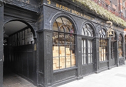
Part of the tiny courtyard has outdoor tables and chairs. These can be used by patrons of the St Jacques restaurant, which occupies number 5 St James Street whose southern wall forms the northern wall of the alleyway. The southern wall of the passage is part of the wall of number 3, which houses the original Berry’s shop. This well-preserved historical shop is lined with wood-panelling and contains much of the old shop fittings.  These include old desks, shelving with old bottles, and a large hand-operated coffee grinder. Suspended from the ceiling, there is a large grocer’s weighing scales. According to Berry’s detailed company history (www.bbr.com/about/history):

“It was in the time of William Jr. and John Clarke that the famous grocer’s weighing scales began to be used to weigh the shop’s many notable customers, a fashionable pastime that continues to this day.”

Had it not been for noticing the alleyway which I have passed often without noticing it, and then spotting the portrait in the courtyard, I doubt we would have ever entered the old shop at number 3. Incidentally, if you wish to purchase wines or spirits from Berry’s, you will need to walk around the corner into Pall Mall, where the company has a newer shop … or, less interestingly, you can make purchases online.

Vanishing point

OF JAMAICAN HERITAGE, the artist Barbara Walker was born and brought up in Birmingham where she lives today. During her childhood, she was taken to see museums and galleries. She noticed that in many works (paintings and other images) of western art, Black people play a peripheral role, depicted as servants and so on, serving the ‘white’ people who play a central role in a picture. Recently (April 2022), we visited an exhibition of her works at the Cristea Roberts Gallery in London’s Pall Mall. Called Vanishing Point, this superb display contains artworks, prints, which address the issue that Barbara noted when she was younger.

At first sight, most of the framed prints appear to be large sheets of white paper with a few beautifully drawn details depicting black people or parts of their bodies. Closer examination reveals that there is more to the white spaces than first meets the eye. The white areas are embossed. The black people, who have been drawn, are surrounded by the embossed areas of the print. Together, the drawings and embossed sections of the print can be seen to be a whole picture. Walker has processed an original image to create a new one in which only Black people in the original are easily visible and the rest of the picture forms a ghostly background. Unlike the pictures she saw when a youngster, the Black people in the picture are prominent and the others are barely detectable.

I am not sure exactly how the artist achieved this interesting effect and these powerful images, but I will have a go at explaining, using my experience of having once made etchings in the past. Metal plates are first coated with a photographic material. Then images of an original painting are projected on to it and processed in some way that produces a photographic reproduction on the plate. The artist, then blocks out selected areas on the plate with an acid-resistant material to produce a pattern that includes many details of the original image, including all of the parts of it that contain depictions of Black people or the parts of their bodies in the original painting or image. The plate is then immersed in acid, which eats into all the parts of it, which have not been painted over with the blocking agent. Then, a sheet of dampened paper is placed on the plate and the two are run through a printing press. The pressure exerted by the rollers of the press force the dampened paper into the depressions on the plate caused by the action of the acid. The result is a sheet of paper with embossed indentations. When the paper has dried, the artist then draws on the flat areas, which are in fact silhouettes of the Black people (or details of them) which appeared in the original painting. The rest of the embossed area, containing details and enough outlines of the original image to make it recognisable, is left white. The result is an image in which Black people become the focus of the viewer’s attention.

Barbara Walker’s works on show at Cristea Roberts (until the 23rd of April 2022) are ingenious and extremely engaging. She has employed an interesting technique to make her statement. Rather than reinforcing the fact that Black people were often depicted as being menial as is the case in the recent display of paintings by Hogarth at the Tate Britain, she has found a way of raising their status in artworks that sought to portray them as mere subsidiaries.

A road with many names

THE WESTERN END of Oxford Street is at Marble Arch. Beyond the latter, its continuation becomes Hyde Park Place and then, after 620 yards it becomes Bayswater Road, before reaching Notting Hill Gate, and then Holland Park Avenue. Oxford Street and its continuation westward follow the probable course of a road or track named by the Romans as Via Trinobantia. It ran from Colchester via London to Silchester (in Hampshire), which was a capital of the Atrebates tribe.  According to Ralph Merrifield in his “Roman London” (published 1969), the Roman thoroughfare ran due west from Oxford Street, along what is now Bayswater Road to Notting Hill Gate. After that, it changed direction so that it headed directly to what is now Staines. Merrifield wrote that its course:

“… is closely followed by Holland Park Avenue and Goldhawk Road, until the latter turns sharply towards Chiswick. The Roman road is then followed by two lesser modern roads, Stamford Brook Road and Bath Road, and crossed Acton Green where it has been obliterated by the railways. Half a mile further west it is represented by Chiswick Road, which leads to Chiswick High Road…”

 On a map drawn by Ralph Agas (c1540-1621) in the 16th century, the part of the Roman highway known now as Oxford Street was marked “The Waye to Uxbridge”. At that distant time (1561), the western edge of London was as far east as Farringdon, which follows part of the now lost Fleet River. This was the case except for riverside strip of buildings along the north bank of the Thames to Westminster.    Oxford Street, so named in the 18th century, has had other names such as the ‘Tyburn Road’, ‘Uxbridge Road’, and ‘Oxford Road’.

A sign on a lamppost on Bayswater Road near to Lancaster Gate Underground station reads “A402 was A40”.  The road running along the northern edge of Hyde Park and Kensington Gardens was designated in 1923 as ‘The London to Fishguard Trunk Road (A40)’.  After the A40 was re-routed, part of it running along the elevated Westway (completed in 1970), the section of the original A40 (and much earlier the Roman road), which ran between Marble Arch and the westernmost end of Goldhawk Road was re-designated the A 402.

Until the early 19th century, what is now Bayswater Road and its western continuation ran through open country, passing Hyde Park, a royal hunting ground established by King Henry VIII in 1536 (and opened to the public in 1637). Before the park was established, the journey west of what is now marble Arch would have been through a rustic landscape and travellers would have been at risk from attacks by robbers, Today, the greatest risk faced by users of Bayswater Road is delay caused by traffic congestion.

Of Merlin and rollerskates

KENWOOD HOUSE IS NEAR both Hampstead and Highgate in north London. It offers the visitor the chance to view not only its lovely grounds and fine interiors designed by the architect Robert Adam (1728-1792), but also a fabulous collection of paintings, many by world famous artists including, to mention but a few, Rembrandt, Frans Hals, Van Dyck, Vermeer, Reynolds, and Gainsborough.

Merlin (painted by Gainsborough) and the invalid cahir he invented

One of the paintings by Thomas Gainsborough (1727-1788) is a portrait of the inventor John Joseph Merlin (1735-1803). The latter was born in Huy (Belgium), and as a young man, he worked in Paris making clocks and mathematical instruments. In 1760, he moved to England to work as a technical advisor to the then new Spanish Ambassador to London. By 1766, he was working with the London jeweller James Cox. Then, he was creating mechanical toys including the Silver Swan, an automaton, still working, that can be seen at the Bowes Museum in Barnard Castle (Durham).

In addition to these ‘toys’, Merlin invented some useful items. These included roller skates; various clocks including one that was powered by changes in atmospheric pressure; improvements to keyboard musical instruments; playing cards for blind people; prosthetic devices; and a self-propelled wheelchair known as ‘the Gouty Chair’. There is an example of this ingenious wheelchair on display beneath Merlin’s portrait in Kenwood House. In my book about Hampstead and its environs, I described it as follows:
“Two handles at the ends of its armrests are connected by rods and cogwheels to some wheels on the floor below the chair. The occupant of this chair could rotate the handles, and thereby propel this early form of wheelchair around the room.”

In the same room as the invalid’s chair, there is another of Merlin’s creations: a skeleton clock made by him in 1776. This kind of timepiece is one, whose working parts are not concealed by casing or any other features that usually hide them.

The portrait of Merlin, painted in 1781 by his friend Gainsborough, shows him in a red jacket, holding a small beam balance in his left hand. Apparently, this was one of his creations. This precision instrument is the only clue that the subject of the painting had anything to do with jewellery or instrument making. His right hand is tucked into his jacket:

“… a customary gesture to signify a polite yet firm manner.” (https://artuk.org/discover/artworks/john-joseph-merlin-17351803-191713)

The painting hangs in Kenwood House because it, like many of the others on display there, were part of the collection of the philanthropist and brewer (of the Guinness beverage) Edward Cecil Guinness, 1st Earl of Iveagh (1847-1927), who bought the house in 1927, and bequeathed it and his collection of paintings housed within it to the nation. You can discover more about Kenwood and nearby Highgate village in my book “Beneath a Wide Sky: Hampstead and its Environs” (https://www.amazon.co.uk/dp/B09R2WRK92 OR https://www.bookdepository.com/BENEATH-WIDE-SKY-HAMPSTEAD-ITS-ENVIRONS-2022-Adam-Yamey/9798407539520 )

Going green in an urban jungle

REMNANTS OF LONDON’S ROMAN wall can be seen from various points in the Barbican Estate, whose construction began in 1965. The not entirely unattractive residential brutalist concrete jungle, known as The Barbican is sited next to the northern edge of what was formerly Roman Londinium. According to a history of the area (www.cityoflondon.gov.uk/services/barbican-estate/barbican-estate-history):

“The name of the Barbican comes from the Low Latin word ‘Barbecana’ which referred to a fortified outpost or gateway: an outer defence of a city or castle or any tower situated over a gate or bridge which was used for defence purposes. The “Barbecana” was probably situated somewhere between the northern side of the Church of St. Giles Cripplegate and the YMCA hostel on Fann Street.”

By the 1850s, the district of Cripplegate, where the Barbican is located, was very crowded with dwellings and business premises. Much of the area now occupied by the Barbican had been destroyed by bombing during WW2. The Estate was built to replace what the Luftwaffe had destroyed.

Apart from several water features, there is one oasis of greenery on the otherwise extremely urban site. This is the Barbican Conservatory. Opened in 1982, it is located above the Barbican’s main theatre and can be entered through an entrance close to that of the Barbican’s Art Gallery. Despite it having been in existence for so many years and having known about it for several decades, it was only yesterday (6th of April 2022) that I first ventured inside it. We had just viewed the current exhibition in the Gallery, “Postwar Modern: New Art in Britain 1945-1965”, an impressive display of rather unexciting artworks. Entering the Conservatory was literally “a breath of fresh air” after viewing the exhibits that had been arranged to illustrate the depressing emotional aftermath of WW2 as depicted by artists in Britain.

I was surprised to learn that the Barbican Conservatory is:

“… the second largest in London (after Kew Gardens) and home to over 1,500 species of plants, but is one of the city’s lesser-known green spaces.” (www.atlasobscura.com)

Apart from the plants, many of them exotic, which are arranged on various levels and can be viewed from both a lower floor and an elevated walkway, there are three ponds. One contains koi carp and the other, raised above ground level, is home to two terrapins, which were found in ponds on Hampstead Heath. The Conservatory is divided into two main sections. The larger is the tropical section, where visitors are permitted to wander about. The other, which was locked up yesterday, is the arid section, containing cacti and succulents.

Despite being in the midst of a manmade, visually intriguing, but harsh urban environment, the Conservatory with its tall trees, bushes, flowers, and other vegetation, feels like another world – a primaeval paradise from which the modern world can be glimpsed in the background.  

The way to the summer ballroom

HOLLAND HOUSE IN Holland Park was badly damaged by aerial bombing during WW2. What is left of the building shows that it must have been a splendid Jacobean palace. It stands on the estate of Sir Walter Cope (c1533-1614), for whom it was originally constructed. In his time, the estate extended south from what is now Holland Park Avenue almost to what is now Fulham Road.

Although much of Holland House was destroyed in the War, many of its out-houses still stand today. Amongst these are the icehouse with its conical roof; a disused dairy; a stable block which now houses a Parks police station; and an orangery, which is attached to what was once the summer ballroom.

A covered arcade, open to the outside on one side, runs from where the southwest corner of the house used to stand, passing near the icehouse, to the southeast corner of the orangery. In poor weather, this long covered passageway was used by house guests moving between Holland House and its summer ballroom. From the western end of the passageway, they would have had to walk through the orangery to reach the ballroom. In fine weather, those attending balls would have walked along the walkway above the covered passage. In places, this runs past walls covered with colourful tiled panels, made in Florence (Italy), which were placed there in the 1850s. The wall of one stretch of the covered walkway, the section nearest to the orangery, are painted with scenes depicting an imaginary garden party held sometime in the 1870s. They were created between 1994 and 1995 by the artist Mao Wen Biao (born 1950).

Currently, the former summer ballroom is being restored. For many years, it was home to The Belvedere restaurant, a pricey establishment. When the restoration of the ballroom is complete and its former glory restored as much as possible, it will be used to house a new Italian restaurant, which is planned to be more affordable than its predecessor.

Over several decades, we have made innumerable visits to lovely Holland Park, but had not realised that the arcade described above was anything but decorative. Today, we met Jenny Kettlewell, who is the Chairman of the Friends of Holland Park. It was she who revealed its purpose. Currently (2nd to 10th of April 2022), there is an annual art exhibition in the orangery. The works on display are by local artists.

A Sunday afternoon in Hampstead and a bit of marketing

FROM CAMDEN TOWN, home of the busy Camden Lock and other popular markets, the 24-bus route more or less follows course of the now buried River Fleet, and ends at Hampstead’s South End Green. We disembarked at the Lawn Road bus stop on Fleet Road and walked the short distance to the Lawn Road Flats, also known as The Isokon. This building, inspired by the avant-garde housing projects in pre-WW2 Germany pioneered by the Bauhaus and similar institutions, was completed in 1934. A relatively bomb-proof structure, it was home to many people involved with cultural activities, including the author Agatha Christie (1890-1976), who wrote several of her novels whilst living there. The modernist block of flats still houses tenants. On Saturdays and Sundays, a small museum illustrating the history of this amazing edifice is open to the public. It contains photographs, information panels, and historical furniture items, all connected with the Isokon and its illustrious tenants. There is also a small, but well-stocked bookshop. It was here that I left several copies of my new book about Hampstead to be available for sale to visitors.

Bust of Agatha Christie at the Isokon Gallery in Hampstead

From the Isokon, we walked past South End Green and up Willow Road, which ascends ever more steeply as it approaches its northern end just near to Flask Walk and our next port of call, Burgh House. The house was constructed at the beginning of the 18th century. Here, we viewed the latest temporary exhibition, “John Cecil Stephenson: A Modernist in Hampstead”, which started at the beginning of April 2022. I will write more about this in a separate piece. Burgh House is home to a museum of the history of Hampstead and to a pleasant and popular café, which serves drinks and both hot and cold foods. The house also contains a small bookshop, well-stocked with a variety of books about Hampstead and artists associated with the place. I left several copies of my book about Hampstead to be sold there.

After spending a relaxing time in the Burgh House café, we wandered along Flask Walk, passing Keith Fawkes antiquarian bookshop, where copies of my book are on sale. Then, we walked onwards along the High Street and Perrins Court, where my father and I used to eat lunches at the Villa Bianca Italian restaurant. Reaching Heath Street, we passed the The Village Newsagent, which stocks my book (can you spot the theme emerging here?), and then entered Church Row. Halfway along it stands St John’s Parish Church.

The neo-classical church was completed in 1747. Twenty-three years before this, the “St Johns Passion” by Johann Sebastian Bach (1685-1750) was first performed in the Church of St Nicholas in Leipzig. At 5pm on Sunday the 3rd of April (2022), we listened to a good performance of this wonderful piece of religious music in the Church of St John in Church Row. With a small choir, a competent orchestra, and excellent soloists, the acoustics were excellent. Very thoughtfully, foam rubber cushions are provided for improving the comfort of the seating in the wooden pews. I was pleased to note that the current (April) issue of the parish newsletter includes a note about my new book.

After watching a colourful sunset, we took a bus to Paddington, where we enjoyed a tasty meal at the Malaysian Tuk Din restaurant not far from the station.

My book “Beneath a Wide Sky: Hampstead and its Environs” is available in Hampstead at the following locations:

THE CAMDEN ART CENTRE (Arkwright Road)

KEITH FAWKES (Flask Walk)

ISOKON GALLERY (Lawn Road)

THE VILLAGE NEWSAGENT (Heath Street)

BURGH HOUSE (New End Square, near Flask Walk)

The book (and Kindle) is also available from Amazon (https://www.amazon.co.uk/dp/B09R2WRK92)

A Victorian hospital and Florence Nightingale

OF CRIMEAN WAR fame, Florence Nightingale (1820-1910) established a nursing school in what is now St Charles Hospital in North Kensington in 1884. In that time, the hospital near the northern end of Ladbroke Grove was called ‘the St Marylebone Union Infirmary’. It was so named because it was built to serve the poor of the parish of St Marylebone. It had to be put up outside the parish because there was no room available to build a hospital within it. This institution was opened in 1881 by the then Prince (future King Edward VII) and Princess of Wales. A very informative website, https://ezitis.myzen.co.uk, revealed that the hospital was:

“… three storeys high, with a central block and four pavilions.  It had accommodation for 744 patients … and 86 resident staff (the Infirmary also had 82 non-resident staff).”

In 1923, the hospital was renamed the ‘St Marylebone Hospital’ and the next year, the then Minister of Health and future Prime Minister Neville Chamberlain (1869-1940) opened an extension, which had just been completed. By 1926, some wards had bedside wireless sets installed.

The hospital was given its current name when the London County Council took over its running in 1930. During WW2, wards on the top floors were closed, but the hospital suffered little damage from enemy bombing. After the war, St Charles served as a general hospital, but by 1998, there were very few beds for in-patients. Currently, the establishment is run by both the Central London Community Healthcare NHS Trust and the Central and North West London NHS Foundation Trust. Now, it is known as St Charles’ Centre for Health and Wellbeing. Most of its patient care is out-patient and since the development of vaccines against covid19, it is also a ‘vaccination hub’.

The original edifices were designed by Henry Saxon Snell (1831-1904). In grey weather, the late Victorian buildings of St Charles with their brickwork and neo-gothic decorative features present a somewhat gloomy or even ominous appearance. In bright sunlight, although they do not seem particularly welcoming, they have a certain charm. The website, http://www.british-history.ac.uk/survey-london/vol37, describes the architecture in more detail:

“The excellent plain brickwork, strong selfconfident design, and assured functional planning and detail make St. Charles Hospital a most significant building for its period. It occupies a rectangular site of three and a half acres near the north-west end of Ladbroke Grove … The buildings are planned on the pavilion principle, each block being, as far as compatible with facility of communication, isolated from the others. There are five parallel pavilions, the central administrative block being flanked on either side by two blocks of wards. The central block is surmounted by a massive tower, 182 feet in height, which forms a prominent landmark when viewed from the north and west. The chimney-shaft from the boilers below is carried up inside this tower, the upper part of which has a corbelled stage derived from northern Italian work of the Middle Ages. The tower contains a number of large tanks, providing storage for 25,000 gallons of water pumped from a well 500 feet in depth … The pavilions on either side of the tower are linked to each other by cast-iron galleries and canopied walks. A block of buildings situated at the entrance contained the residences of the medical officers, and over the spacious arched gateway in the centre there was a chapel 60 feet long by 30 feet wide, with a boarded wagon-roof of trefoil section. In a report on the infirmary written by Snell, he described the elaborate systems of heating and ventilation. Open fires heated coils of pipes containing water which then circulated, humidity also being contrived so that air would not be dried, a great advance for the time. The lighting was by gas, and fumes were carefully vented away. This ‘Thermhydric’ system, patented by the architect, included upright flues in the external walls, inlets being provided for fresh air which was warmed as it entered, and air was also admitted directly through the walls into skirtingboxes between the beds, while flues carried off the foul air and the products of gas combustion.”

Although it was clearly an advanced building for its time and it is not far from the much-visited Portobello Road, this hospital is unlikely to be on many visitors’ itineraries. However, lovers of Victorian architecture might enjoy seeing it even if they had no clinical requirement to do so.

Will this village near Heathrow Airport disappear?

SITUATED AT THE northwest corner of Heathrow Airport (and within sight of it), is the former village of Longford. Now in the Borough of Hillingdon, it lies on what was once the main road between London and Bath. Its name derives from a ford which used to cross the River Colne. James Thorne, writing in 1876, noted that there were then three roadside inns and that:

“The fishery here is in good repute among anglers; as is also the Kings Head Inn.”

Today, there are only two pubs in Longford, The Kings Arms and The White Horse. The Kings Head, marked on a map surveyed in 1875, no longer exists. It stood just east of the Duke of Northumberland’s River, near the boundary fence of The Thistle Terminal 5 Hotel. Nearby, next to a bus stop (Stop J), stands the now disused Longford Pump. This is almost 10 feet tall and was used to top up the tanks of steam-powered traction engines. Of the two surviving inns, The White Horse looks to be the oldest. According to a notice attached to this picturesque old pub, it was probably built as a smokehouse (for curing meat) in 1534 and became an inn in 1601.

Cottage in Longford

Across the road from The White Horse, there is a magnificent half-timbered building. This Elizabethan (16th century) edifice is Yeomans House. The historian Wendy Tibbits wrote (www.wendytibbitts.info):

“In 1542 Leland in his ‘Itineraries’ describes a building about a mile north of the wooden bridge over the Colne between Longford and Colnbrook, which suggests it could be the building now known as Yeomans. At the time it was the manor house of Colham and owned by the Earl of Derby who died there on 23 May 1521. He had built the Tudor Manor House on the site of a medieval house. At that time the manor of Colham had extensive land extending from Hillingdon southwards … In the mid-eighteenth century this house was owned by Thomas Streeting who died there in 1773. It was inherited by his daughter, Elizabeth, who had married the other prominent Longford farmer, Thomas Weekly. Thomas, his wife, and their nine children were living in the Weekly house, a hundred meters along the Bath Road, and so they decided that the Elizabethan would be divided into three dwellings and rented to their farm labourers’ families …”

Between The White Horse and The Kings Arms, there is a charming, thatched cottage. Almost opposite this, there is a three-storey brick building, now next to the entrance of the Heathrow Medical Aeromedical Centre. According to Ms Tibbits, this is the house built by a wealthy London cloth merchant, Thomas Weekly, about 10 years after the 1666 Great Fire of London. The Weekly family lived here from the late 17th century until 1899. The house had its own farm, which was compulsorily purchased during WW2 to use the land for the construction of an airfield in the neighbouring, now demolished, hamlet of Heathrow.  

The Kings Arms Pub faces Heathrow Close. Immediately to the east of the hostelry, there is an old long barn with a sagging roof. This is one of the few reminders of the era when Longford was in the midst of agricultural terrain. To the west of this pub, the old road to bath crosses the River Colne over a bridge with elegant cast-iron railings and roundels, each with a crown and beneath it, the following: “WR IV 1834”. This is marked on old maps as “The King’s Bridge”.

Longford contains the remnants of what was once a small country village. Ms Tibbits noted that:

“… its four inns provided travellers with hospitality. Six miles from Windsor Castle the village was the usual stopping place for the Royals to change their horses on the way to and from London and Windsor … Highwaymen prayed on the coach travellers who had to cross the notorious Hounslow Heath to get to Longford, but if any villagers were aware of the culprits they kept it to themselves.”

Sadly, like nearby Harmondsworth, Longford’s future might well be bleak. Should the projected extension of Heathrow Airport finally get the ‘go-ahead’, much of Longford, if not all of it, will be demolished. This would be a great pity as it would involve the displacement of a small community and the loss of several buildings of historical interest.