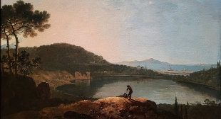
DURING A RECENT visit to the Tate Britain art gallery in London, we stopped to view a room that contained paintings of birds. All the paintings except one contained depictions of at least one bird. The exception, in which there was no bird to be seen, was painted by Richard Wilson (1713-1782).
The painting is called “Lake Avernus and the Island of Capri”, and was painted in about 1760. Lake Avernus is near Naples (Napoli). In Roman mythology, it was believed by to be the mouth of Hades, the hellish underworld described in the “Aeneid” by the Roman author Virgil (70 BC – 19 BC). This evil place was believed to emit fumes that killed any birds flying over it.
The name Averna is derived from the Greek word ‘aornos’, which translates as ‘without birds’. Hence the absence of birds in Wilson’s painting.
COVERED WITH HIEROGLYPHS, and standing close to Istanbul’s Sultanahmet Mosque, there is a tall obelisk mounted on 4 metal brackets, which rest on a stone block covered with bas-relief carvings. It is called Dikilitas in Turkish, and The Obelisk of Theodosius in English.
Over 65 feet tall, it is only a small part of an obelisk that was commissioned by the Egyptian Pharaoh Thutmose III (1549-1503 BC), and it stood opposite Thebes. The fragment that stands in the former hippodrome of Istanbul was brought to what was then Constantinople in the 4th century AD. It was erected in its present position by Emperor Theodosius the Great in 390 AD.
The carvings on the plinth that support the obelisk depict Theodosius and his officials involved with the races that were held in the hippodrome. The obelisk and two other vertical structures marked the cental line or long axis of the race course.
During our current visit to Istanbul, we often walk past the obelisk on our way to our nearest tram station. We usually do this in daylight. However the best time to see the obelisk is after dark when it is beautifully illustrated with spotlights that enhance the appearance of both the hieroglyphs and the sculptures below it.
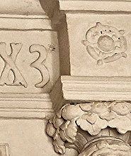
TRERICE HOUSE IN Cornwall was built mainly between 1570 and 1573. It is one of the loveliest National Trust (‘NT’) properties in the county and one of my top ten. In one of the upper rooms there is an ornate bas-relief above the fireplace. The top of this bears the following:
“ANNO: DOMINI: M : CCCCC : LXX3”
It is clearly a date in mostly Roman numerals, (i.e., 1573). However, this date has several odd features.
‘CCCCC’ is 500, but usually abbreviated to ‘D’ in Roman numerals. There is a surplus of colons (‘:’) and instead of ending in a Roman numeral, there is the Arabic numeral ‘3’. Or is it the symbol for a serpent, rather than a ‘3’? It is a curiously shaped 3: it is widest at the top and tapers towards its lower end.
The NT volunteer offering information in the room with this curious date suggested three possible explanations for this peculiar form of the date above the fireplace. One is that the creator of this date miscalculated the amount of space, and instead of ending the date in ‘: III’, used the Arabic ‘3’ to fit in the last part of the date. Had he used ‘D’ instead of the unusual ‘CCCCC’, there would have been plenty of space to fit in the entire date using only Roman numerals. Another explanation offered is that the ‘3’ is really a stylised serpent, a symbol of wisdom often associated with Queen Elizabeth I, during whose reign the house was built.
3 or a serpent?
The last explanation was provided by a builder, who had visited Trerice some weeks before us. He suggested that the ‘3’ was added to indicate that the building works were supposed to have been completed in 1570, but had finished 3 years later than expected; the builders were running behind schedule.
Whatever the explanation of the curiously written date, and you might have another theory, Trerice is well worth a visit.
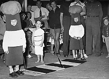
MY PARENTS WERE born in South Africa. They settled in England in about 1947/48. In 1955, when I was three years old, my parents took me on a visit to their native land, possibly to show me off to relatives who lived there.
We travelled to Cape Town by sea. I remember nothing of the voyage, which must have taken about two weeks. Recently, I came across a photograph, which had remained in storage for several decades in my late father’s garage. The picture shows a little boy in a white outfit resembling a Roman toga. He is standing between two children dressed up to resemble, if your imagination is good enough, Belisha beacons such as are found at pedestrian crossings of the zebra variety.
The photograph reminded me of what my mother had told me many years ago. During our voyage to South Africa, we crossed the Equator. My mother told me that to celebrate this event, there was a fancy-dress party for the children on-board. My mother, unlike some of the other parents, had not been aware that this was going to take place. So, she had not packed a costume for me to wear. Ever resourceful and extremely creative (she was a painter and sculptor), Mom used one of the sheets from a bed in our cabin to wrap me up as if I was wearing a toga. Looking at the photograph, it appears that also she fashioned a pair of what look like Roman sandals, using some string. Thus, during my first crossing of the Equator, I was attired in a Roman toga.
Looking at this image, which includes a rug designed to look like a pedestrian crossing, made me think. There I was standing halfway across a zebra crossing whilst our liner crossed from one side of the Equator to the other.
REMNANTS OF LONDON’S ROMAN wall can be seen from various points in the Barbican Estate, whose construction began in 1965. The not entirely unattractive residential brutalist concrete jungle, known as The Barbican is sited next to the northern edge of what was formerly Roman Londinium. According to a history of the area (www.cityoflondon.gov.uk/services/barbican-estate/barbican-estate-history):
“The name of the Barbican comes from the Low Latin word ‘Barbecana’ which referred to a fortified outpost or gateway: an outer defence of a city or castle or any tower situated over a gate or bridge which was used for defence purposes. The “Barbecana” was probably situated somewhere between the northern side of the Church of St. Giles Cripplegate and the YMCA hostel on Fann Street.”
By the 1850s, the district of Cripplegate, where the Barbican is located, was very crowded with dwellings and business premises. Much of the area now occupied by the Barbican had been destroyed by bombing during WW2. The Estate was built to replace what the Luftwaffe had destroyed.
Apart from several water features, there is one oasis of greenery on the otherwise extremely urban site. This is the Barbican Conservatory. Opened in 1982, it is located above the Barbican’s main theatre and can be entered through an entrance close to that of the Barbican’s Art Gallery. Despite it having been in existence for so many years and having known about it for several decades, it was only yesterday (6th of April 2022) that I first ventured inside it. We had just viewed the current exhibition in the Gallery, “Postwar Modern: New Art in Britain 1945-1965”, an impressive display of rather unexciting artworks. Entering the Conservatory was literally “a breath of fresh air” after viewing the exhibits that had been arranged to illustrate the depressing emotional aftermath of WW2 as depicted by artists in Britain.
I was surprised to learn that the Barbican Conservatory is:
“… the second largest in London (after Kew Gardens) and home to over 1,500 species of plants, but is one of the city’s lesser-known green spaces.” (www.atlasobscura.com)
Apart from the plants, many of them exotic, which are arranged on various levels and can be viewed from both a lower floor and an elevated walkway, there are three ponds. One contains koi carp and the other, raised above ground level, is home to two terrapins, which were found in ponds on Hampstead Heath. The Conservatory is divided into two main sections. The larger is the tropical section, where visitors are permitted to wander about. The other, which was locked up yesterday, is the arid section, containing cacti and succulents.
Despite being in the midst of a manmade, visually intriguing, but harsh urban environment, the Conservatory with its tall trees, bushes, flowers, and other vegetation, feels like another world – a primaeval paradise from which the modern world can be glimpsed in the background.
ROMANS TRAVELLING ON the ancient Dere Street, a road constructed by the Romans, between York and Hadrian’s Wall crossed the river Ure near the present Yorkshire village of Aldborough, which archaeological research has revealed stands on the site of a large Roman town called ‘Isurium Brigantum’. Some of the Roman remains can be seen at the beautifully laid out English Heritage site in Aldborough. The parish church in Aldborough is built on the site of the forum of the former Roman town and contains a Roman sculpture, which might well depict the god Mercury. Excavations, which we viewed, being undertaken by archaeologists from Cambridge University are discovering that the Roman town was an important way station for supplying and servicing troops travelling to and from Hadrian’s Wall. The archaeologists, who kindly showed us around their dig, asked us not to reveal what they have discovered because they have yet to be published in the appropriate way.
A carved Saxon stone incorporated into the masonry of a church wall at Kirby Hill, Yorkshire
After crossing the Ure at Aldborough, Dere Street, so named after the Romans had departed from Britain, travelled north to Catterick (Roman: ‘Cataractonium’). A few miles from Aldborough, the old road used by the Romans passed close to the Yorkshire village of Kirby Hill, whose parish church, All Saints, perches on the summit of a hill. It is possible that the church is sited where once there was a Celtic and/or Roman shrine. The church’s informative website (www.allsaintskirbyhill.org.uk/) reveals:
“… there are some large stones in the lower walling; one of these at the South West angle is clearly Roman and has a sunk panel, which once contained a 13 line inscription. Unfortunately, it is now very badly weathered. It was a posthumous dedication to either Antonins Pius or Caracalla, the first such recorded from Roman Britain.”
Unfortunately, when we visited this lovely church recently, we missed seeing this interesting souvenir of the Roman occupation of Britain. However, during our brief look inside the church we did see evidence of some of the invaders who arrived in Britain after the Romans had left.
The church contains some well-preserved carved fragments of Saxon crosses. High up on the south side of the church, we noticed that such a fragment had been incorporated in the stonework of its wall, just as the Roman stonework had been incorporated elsewhere in the structure of the church as already described.
The nave of All Saints was built both during the Saxon and Norman eras. Its structure includes some Saxon slabs as well as those placed after the Norman invasion in 1066. A north aisle was added in about 1160 and is separated from the older part of the church by semi-circular masonry arcades supported by sturdy stone pillars topped with capitals dating back to Norman times.
The church, which we only visited because we followed a roadside direction sign with the words “Ancient Church”, contains many other interesting features, which we did not have time to examine as we were in a bit of a hurry to reach an appointment on time. When we told a lady, who was telling us about the church, that we were rather pressed for time, she said to us, smiling:
“That’s a pity. You’re speaking with the wrong person. You can’t expect someone from Yorkshire to be brief.”
A SHORT REMNANT OF the old Roman city wall, which used to surround London, runs just south of the church of St Giles Cripplegate, which itself is on the southern edge of the Barbican complex. The garden of Salter’s Hall lies where once a moat ran along the outer side of the wall. And on the other side of the wall, between it and the wide road called London Wall (the A1211), there are the remains of a mediaeval structure, which look as if they might have been the lower part of a gothic tower. These ruins can be examined close-up or a few feet away, seated at a table under the awnings of Barbie Green, an Australian-style, contemporary eatery, which serves good coffee. The restaurant is relatively new, but the ruins have been there far, far longer. Oddly, although we have passed this area often, it was only yesterday, 16th of August 2021, that we first noticed them.
A notice next to the ruins explains that they are all that remains of the tower of St Elsyng Spital, which was also known as ‘The Hospital of St Mary within Cripplegate’ (www.british-history.ac.uk/vch/london/vol1/pp535-537). This hospital was founded in 1330 by the merchant, a mercer, William Elsyng as a college for priests and to provide shelter and other assistance to London’s homeless blind people (https://ethos.bl.uk/OrderDetails.do?uin=uk.bl.ethos.538317). A victim of the Black Death, he died in 1349. Following his instructions, after his death it became an Augustinian priory, which survived until it was dissolved in 1536 during the reign of King Henry VIII. After its dissolution, the parishioners of the nearby St Alphage Church, which had become derelict, purchased the church of Elsyng’s establishment. According to the architectural historian Nikolaus Pevsner, the 14th century tower, whose remains we saw, was incorporated into the structure of St Alphage. St Alphage was demolished at the end of the 16th century and its parishioners used what was left of Elsyng’s priory church, which was eventually replaced by a newly built church on a different site in 1777 (https://en.wikipedia.org/wiki/St_Alphege_London_Wall).
The well-maintained ruins consist of several tall gothic arches connected to each other by walls made of roughly hewn stones and mortar. Most of the arches are arranged around what was once the base of a tower. This mediaeval site is surrounded by modern buildings, lies beneath a sinuous elevated oxidised metal walkway. It is sandwiched between the fragment of London’s Roman Wall and the busy London Wall dual carriageway. Part of the joy of stumbling across this relic of pre-Reformation architecture is that unlike so many others we have seen on our travels, it is in the heart of a modern metropolis rather than a rustic environment.
Small though it is in comparison with its modern surroundings, finding this reminder of London’s distant past, founded long ago by a philanthropic merchant, was a delightful surprise. Even today, so many centuries later, philanthropy thrives in the heart of the old City of London in the form of the descendants of the guilds, of which The Salters, whose hall I mentioned above, is just one example of many.
ONE EASTER DURING the late 1990s, we drove to Provence in the south of France. There, we hired a lovely rural cottage (a ‘gîte rural’) located on the edge of a village next to an orchard of trees overladen with ripe cherries. That year, there was a heatwave in the south of France, daytime temperatures reaching and staying at 37 degrees Celsius. We were pleased that our Saab saloon car had built-in air-conditioning and that our gite had a large garden and a shady terrace.
Roman amphitheatre, Orange, France
Despite the high daytime temperatures, we managed to do plenty of sight-seeing. One day, we decided to explore the delights of the city of Orange, which was not far from our gite. The city is rich in Roman remains including a magnificent open-air theatre with steps, on which the audience perched, arranged in a circle.
In the 12th century, Orange and its surroundings became a principality within the Holy Roman Empire. In 1554, William the Silent, Count of Nassau, who had possessions in the Netherlands and became a Protestant, inherited the title ‘Prince of Orange’. The Principality of Orange was incorporated into what became the House of Orange-Nassau, whose royal family continues to rule the Netherlands today. One member of the family became King William III of England in 1689. Orange remained a Dutch possession more or less continuously until the Treaty of Utrecht in 1713, under whose terms it was ceded to France.
So much history and clambering around the Roman ruins made us ready for lunch. We had no idea which restaurant to choose in the centre of Orange. My wife had the bright idea of entering one of the local shops, a shoe store, to ask where its workers went to eat their midday meal. They told us about a small restaurant around the corner. This busy eatery had a name which brought to mind associations with the American Wild West, ‘Le Buffalo West’, or something similar. It was a good recommendation and the food it served was excellent quality, reasonably priced French fare.
After a decent meal, we drove to a parking plot near a Roman triumphal arch. To enter the parking area, one had to drive below an arch designed to keep out large vehicles, and then down a steep ramp. Unfortunately, I turned the steering well before the car was fully off the ramp. We became grounded on a large concrete rock. The engine cut-out. I could not restart it. The car was well and truly stuck on the rock. Some people nearby saw our plight and told us that there was a repair garage a few yards away. We walked there.
The garage people sent out a team with a tow truck. Sadly, the truck was too high to pass beneath the height-restricting arch. Seeing the problem, three garage employees set to work with spades to dig around the rock on which our Saab was marooned. After at least an hour and a half’s hard toil in the baking afternoon heat, they removed the boulder and thus freed the car. Then, they pushed it beneath the arch so that it could be attached to the towing truck.
Raised on a ramp, it was easy to see where the rock had ruptured the Saab’s fuel line. It did not take the engineers long to replace the fractured section. Luckily, little other damage was visible beneath our car. Finally, we were ready to leave. It was with some anticipation that I asked to settle the bill. Imagining how expensive this labour-intensive episode would have been in the UK, I was expecting a bill of at least £300. So, I was not surprised when I was asked for about 300 French Francs. Then, a moment later, I could not believe my luck. A quick calculation had revealed that I was being asked not for £300, but for the Franc equivalent of about one tenth of this amount.
We returned to our gite, highly relieved that the car was back in service so quickly. That evening, as the sun set, we sat outdoors and enjoyed glasses of the local rosé wine whilst the charcoal on our barbecue began to reach the glowing stage that is best for grilling the meat that we had bought in one of the local markets.
The Saab remained in use for several more years but, to the surprise of our local dealer who serviced it annually, it began developing ominous cracks in its chassis. It was providential that these did not develop immediately after my driving misjudgement in that car park in Orange.