Three towns in Devon

WHEN YOU LEAVE THE A38 road near Buckfastleigh and head southwards, you enter the Devonshire district of South Hams. This picturesque part of southwest England contains three towns that attract many visitors: Dartmouth, Kingsbridge, and Salcombe. Each is located on hilly terrain and has its own distinctive charms. All of them have steep streets that lead to places with great views.

BLOG HAMS 2

Dartmouth, the home of an important large naval college, occupies a position on the estuary of the River Dart. Although it attracts many holidaymakers, it has the feel of a working town. The river is filled with boats, some used by pleasure seekers, and others (including ferry boats and fishing vessels) are working craft.

Salcombe, like Dartmouth, perches on the slopes of the shore of an inlet of the sea. Of the three places mentioned in this essay, it has to win first prize for its setting and attractiveness. I have visited Salcombe both in August (high season) and in May (before the season began). During the high season, the small town is flooded with holidaymakers, day-trippers and those staying in the place (including many owners of second homes). The streets are almost clogged with people. In contrast, when we visited it in May, the tiny town was delightful and relaxing.

We have just returned from staying in Kingsbridge, which is a few miles up the same inlet as Salcombe. This is, at first sight, the least obviously alluring of the three towns. Hence, it attracts fewer visitors than Dartmouth and Salcombe. However, as you wander around the small streets in the historic centre of the town, its charms reveal themselves to the viewer. The town is rich in buildings from the 18th and early 19th centuries. The Quay, where the tidal inlet meets the town is beautifully landscaped. Visitors tend to congregate here to enjoy paddle-boarding, boating (when the tide is high enough), crab fishing, eating ice cream,and just passing the time of day. Also, the town has several excellent restaurants. Of these, I would single out: The Old Bakery (for well-prepared Mediterranean and Middle-Eastern style food), the Dodbrook Arms (with first-class cod and chips as well as other perfectly prepared dishes), and Woodys, which serves very good locally reared beef. Like Dartmouth, but unlike Salcombe, Kingsbridge gives the feeling of being more than a holiday destination; it is a real working town.

In between the three towns, there are many villages and beaches worthy of exploration. Of the three places, Kingsbridge has become my favourite and we hope to return to it soon to use it as a base to get to better acquainted with South Hams.

A bridge and a king


KINGSBRIDGE IS A SMALL town in South Devon. It lies at the head of an inlet of a ria (a completely submerged river valley) upon which the better-known and more popular resort of Salcombe is also located.

BLOG KING 3

 Many histories of Kingsbridge relate that the town resulted from the union of two neighbouring settlements, the neighbouring royal estates of Alvington and Chillington. Kingsbridge was formed around a bridge (possibly, a draw-bridge) that connected the two at the head of the inlet of the ria. The bridge was built by the 10th century. So far, so good, but today there is no bridge in the town of Kingsbridge.

If you drive from Kingsbridge towards Dartmouth via the A379 road, you will soon arrive at the New Bridge west of the town. This not so new bridge with five arches was built in 1845 and restored several times since then. It crosses Bowcombe Creek, another branch of the ria. This bridge is not, and has never, ben inside the town of Kingsbridge; it is well outside it. It is not, as has been suggested to me by several locals, the bridge that gave the town its name. So, where was the bridge?

By chance, I found a book about the history of Kingsbridge on-line. It is “Kingsbridge and its Surroundings” by SP Fox, published in 1874. This is the only source that I have found so far that mentions the site of the bridge in Kingsbridge. On page 10, the author noted:

“Nearly at the lower end, Fore Street is crossed at angles by Mill Street and Duc’c [now called Duke] Street, the former on the west side, leading to West Alvington and Salcombe; the latter on the east, in the direction of Totnes and Dartmouth, and uniting the towns of Kingsbridge and Dodbrooke by a very small bridge.”

The old bridge mentioned by Fox no longer exists, but the two streets mentioned do. Duke Street, which used to run through from Fore Street to Church Street near to the present Duke of Prussia pub (according to a late 19th century map), is now a cul-de-sac on which you can now find the main entrance to a popular fish and chips shop called ‘The Cod Father’. Mill Street is still a road leading towards West Alvington and Salcombe.

Where Fox describes the bridge, there is no sign of a ditch or stream today. Maybe, long ago there might have been a ditch or stream across which the bridge straddled. At the head of the inlet of the ria in Kingsbridge, there is a small arch, which might be the outlet to a formerly visible stream, which has long since been covered.

To add some complexity to the story, a modern source (https://kingsbridge.gov.uk/wp-content/uploads/2020/01/B13-Kingsbridge_Devon-Historic-Market-and-Coastal-Towns-Survey-Report.pdf) suggested that the bridge after which the town was named was not within the town itself but some way outside it:

“The exact site and function of the bridge is of great interest, as clear documentary evidence for an  Anglo-Saxon bridge in Devon is rare (Henderson and Jervoise 1938, 29; Hoskins 1954, 147), and, in the present context, because the development and character of the town, like its name, can be expected to have been fundamentally linked with that of the bridge and its highway. The attraction and shaping of urban growth to main roads and river crossings is a strong pattern across medieval Devon (Slater 1999). The detailed map analysis for the urban survey indicates that the early bridge may have crossed   the River – between routes later altered to become Love or Boon’s Lane on the west side, and Quay Street on the east – downstream from a tidal ford on the Mill Street-Duke Street route and below the extent of the medieval town…”

So, we cannot be certain of the location of the old bridge.

The coat of arms of Kingsbridge consists of a three-arched bridge surmounted by a royal crown. Whether or not the bridge had three arches is not at all certain, but the fact that it linked two royal estates justifies the presence of the crown. If the bridge was located where Fox believed, there was hardly enough width for a bridge with three arches.

But who was the king? It might well have been King Edgar, ‘The Peaceful’, who reigned from 959 to 975 AD. For, it was during his reign that a charter relating to boundaries dated 962 AD mentions the existence of a ‘king’s bridge’. That could also mean that the bridge was in existence before that king’s reign.

So, regardless of the actual position of the bridge after which Kingsbridge is named, we can be certain that the name is justified as there was a bridge somewhere in or near the town and it had royal connections. Whatever the origin of the name, the town of Kingsbridge is well worth a visit.

Richmond, Russell, and India

DID THE YOUNG BERTRAND RUSSELL ever rush up King Henry’s Mound in Richmond Park and enjoy the famous view of St Pauls Cathedral ten miles away? We might never know the answer to this, but there is a good chance that he did (on days with clear sky) because this small hillock (184 feet above sea level) that might once have been a Neolithic burial ground is only about 330 yards from Pembroke Lodge. This Georgian mansion in Richmond Park was built in the mid-18th century. In between 1788 and 1796, it was extended according to plans by the famous architect Sir John Soane (1753-1837). In 1847, Queen Victoria granted the lodge to her then prime minister, John Russell (1792-1878).


RUS 6

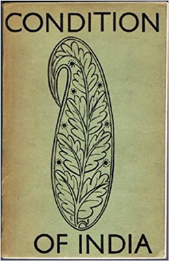
Eric Gill’s cover for the book in which Bertrand Russell wrote the preface

John Russell had a son, John Russell (Viscount Amberley), who was born in 1842. He died in 1876, four years after his son, Bertrand Arthur William Russell, was born (in Monmouthshire, Wales). Bertrand’s mother died in 1874. Bertrand and his brother were placed in the care of their grandparents, who were living at Pembroke Lodge. Had Bertrand’s parents lived longer, they would have been pleased to have learnt that their son was awarded a scholarship to study mathematics at Trinity College Cambridge in 1890.

Bertrand Russell was one of the greatest philosophers of the twentieth century, but I am not qualified to describe his contributions to that field. In his autobiographical book “Unended Quest”, the famous Karl Popper (1902-1994) wrote of Russell that he was:

“… perhaps the greatest philosopher since Kant.”

That was praise indeed.

When I visit places for the first time, they often ignite new interests. Pembroke Lodge was  no exception, and visiting it sparked my interest in its former inhabitant Bertrand Russell. It appears that he was interested in a huge range of things. One of these, which also interests me, was the Indian freedom struggle that culminated in the country becoming independent in August 1947. Wikipedia reveals:

“During the 1930s, Russell became a close friend and collaborator of V. K. Krishna Menon, then President of the India League, the foremost lobby in the United Kingdom for Indian self-rule Russell was Chair of the India League from 1932-1939.”

Krishna Menon (1896-1974), born in Telicherry (now in Kerala, India) came to study at the London School of Economics (‘LSE’) in 1925, then at University College London. He became a keen promoter of the idea of independence for his native land. He was founder and president of the India League from 1928 to 1947.  The League was Britain’s foremost and most influential organisation fighting against the continuation of British imperialism. During the 1930s, Bertrand Russell was one of its its leading supporters and its Chairman for a while.

In 1932, the League decided to send a delegation to India to investigate conditions there. The group, which included Menon, spent 83 days travelling the length and breadth of the country, interviewing people, Indians and Britishers, in all walks of life. After the delegation returned to the UK, they prepared a damning report, “Condition of India”, which was banned by the Government of India but published in England in 1932. Its cover was designed by the artist Eric Gill (1882-1940) and Bertrand Russell wrote its preface. Bertrand Russell began the preface with the following words

“… TO obtain a true picture of the present state of affairs in India is as important as it is difficult. Many English people content themselves with the remark that India does not interest them. If India were independent, they would perhaps be justified in this attitude, but so long as the British insist upon governing India, they have no right to ignore what is done in their name by the Government which they have elected. There has been no lack of interest in the misdeeds of the Nazis in Germany; they have been fully reported in the Press, and have been commented on with self-righteous indignation. Few people in England realise that misdeeds quite as serious are being perpetrated by the British in India. Large numbers of men and women, including many of the highest idealism, have been imprisoned under horrible conditions, often without any charge having been made against them and without any hope of being brought to trial…”

Later in the same piece Russell wrote:

“In India, the peasants are powerless against the landlords and the Government combined, so that no economic lesson is learned from their hardships, and they are expected to ‘Starve quietly without making a fuss’. Only people with political power have a right to make a fuss ; this is one of the great lessons of history, and, lest history should not sufficiently impress the Indians, we are teaching it by the lathi and the gaol. Our ruling classes have lost their former skill, and I fear the ultimate result of their folly In India must be disaster. For in India, also, if the new regime is ushered in by bloodshed the result will not be so good as if it came peacefully. Statesmanship is dead in the post-war world, and India, like other countries, suffers in consequence.”

Like the philosopher Richard Congreve (1818-1899) many years earlier (in 1857), Russell was clearly convinced that the British should leave India. By 1938, Russell, who had dedicated a substantial part of his political activity to matters regarding the future of India, began to concentrate more on philosophy and academia. In the late 1950s, he re-entered political activity, becoming one of the founder members of CND, which opposed the atomic bomb and other nuclear weaponry.

Incidentally, after India became independent, Russell’s former collaborator in Indian affairs, Krishna Menon, then India’s High Commissioner to the UK, and others including Jawaharlal Nehru and Edwina Mountbatten founded the India Club in 1951. In the mid-1950s, its premises shifted to 145 The Strand, near the LSE and India House, where it still stands today. Its shabby looking second floor restaurant preserves its original 1950s look and houses a portrait of Krishna Menon. It has a nice old-fashioned bar on the floor below. A few years ago, before the India Club got a licence to serve alcohol in its restaurant, alcohol could only be served to members of the Club. The only requirement for joining it was to pay an annual subscription of 50 pence.

Returning Pembroke Lodge, we enjoyed hot drinks with our friends in its tranquil garden. It was then that one of our friends pointed out its links with the great philosopher, who spent his childhood there (from 1876 to 1894). After returning home, I looked up Bertrand Russell on the Internet and that is when I found that he had a connection with the history of India. It is wonderful that someone brought up in such fine surroundings as Pembroke Lodge should have felt moved to fight for the people of India, very few of whom would have enjoyed such a luxurious childhood as Russell did.

Decorated walls

DURING RECENT TRIPS TO villages and small towns in Essex and Suffolk, we have noticed that some of the plastering on the external walls of buildings is decorated with patterns and illustrations in bas-relief instead of being flat and featureless, as it often is. I first became aware of this decorative plasterwork on a house in the tiny village of Tollesbury in Essex. As we begun to see more examples, my curiosity about it grew. When we visited Saffron Walden, we saw that the outer wall of a bookshop was covered with plasterwork with patterns and symbols. I decided that if anyone would know about this kind of plastering, it would be someone working in what looked like a serious bookshop.

PARG 12 Saf

In Saffron Walden

I entered Harts bookshop and noticed two things. Firstly, the shop was very well stocked. It was a place where one might spend quite a long time browsing. Secondly, the shelving units looked very familiar. I mentioned to the sales assistant that the shelving resembled that used by branches of the excellent Daunt’s bookshop chain. She replied that despite its name, Hart’s is now a branch of Daunt’s. Saffron Walden is lucky to have such a fine bookstore. I asked the assistant about the plasterwork with decorations that was on her shop and other buildings in the area. Another customer overheard me and explained that what I was asking about is called ‘parget(t)ing’. According to Wikipedia:

“Pargeting derives from the word ‘parget’, a Middle English term that is probably derived from the Old French pargeter or parjeter, to throw about, or porgeter, to roughcast a wall.”

However, the frequently fine and intricate patterns and illustrations created on the plaster suggest that creating pargetting involves little if any ‘throwing about’ of plaster but rather much care in its application.

The patterns or drawings were/are often produced by filling moulds with plaster while the wall is being plastered. An important ingredient in the plaster used to create these three-dimensional images and to give them some cohesive strength is fibre. 

The website http://www.buildingconservation.com suggests that:

“English plasterwork became increasingly elaborate in the 16th century and the dramatic external decoration of Henry VIII’s Nonsuch Palace (1538) was contemporary with early plaster friezes in the great houses. Some of the most opulent pargeting was produced over the next 150 years with a high point around 1660 (for example, Ancient House, Ipswich, and the Sun Inn, Saffron Walden), then the technique began to fall out of fashion.”

Later in the 19th century, some architects like Norman Shaw who were involved in the Arts and Crafts Movement revived pargetting, but the effects produced were far less spontaneous looking than those produced by earlier craftsmen. The same website explains:

“The simplest pargeting takes the form of lines scratched with a stick across wet plaster to create, for example, a lattice within a border. More complexity comes from using fingers and combs or moulded templates, incising or impressing chevrons, scallops, herringbones, guilloches, fantails, rope patterns and interchanging squares.”

To create the images that can be seen in pargetting, the plaster used needs to have sufficient cohesive strength. This can be achieved by adding fibre to the plaster mix. According to the http://www.plasterersnews.com website:

“Early pargeting was always worked in lime plaster which had three main ingredients; lime, aggregate and hair … Traditionally it was probably cow or horse hair but BSE stopped them being used and imported goat and yak hair became popular.”

Modern craftsmen conserving pargetting sometimes use synthetic fibres instead of natural hair because some of the modern sources of natural hair have been washed and this removes natural oils, which prevent the hair dissolving in the plaster.

If you, like me, did not know about pargetting before, now you do. When the man in Harts bookshop mentioned ‘pargetting’, “The Archers”, the British radio serial set in a country village, sprung to mind. One of the memorable characters in this series, which was first broadcast in 1950, is a man called Nigel Pargetter. Sadly, his death was recorded in The Guardian newspaper on the 3rd of January 2011. The paper recorded:

“Pargetter, played by Graham Seed for almost 30 years, was felled by the combination of a loose slate, a flapping happy new year banner on the roof of his home, and the need for a rousing climax to the special half-hour 60th anniversary episode, which the producers promised would ‘shake Ambridge to the core’. It had been, the BBC said, ‘a tough decision’”

You will be relieved to learn that Grahame Seed, the actor who played the role of Nigel Pargetter, still thrives.  Nigel might be dead but pargetting still survives and serves to add visual interest to many buildings in East Anglia.


A beautiful bank

FOUR THOUSAND THREE HUNDRED FLOWERS of Crocus sativus needed to be picked in order to produce an ounce (about 28 grams) of saffron in the sixteenth century. I learned this from a magnificent guidebook to East Anglia, written by Peter Sager. The fields surrounding the town of Saffron Walden in Essex used to be filled with the crocuses that were the source of the precious food additive saffron. The saffron industry flourished around the town during the 16th and 17th centuries, but by the 19th century the fields that had once been filled with crocuses became filled with barley. Even though the precious product saffron is hardly produced any more, Saffron Walden is a pleasant small town filled with interesting old buildings. One of these, which is far from being the oldest, now houses the local branch of Barclays Bank.

The centre of the square marketplace in Saffron Walden contains a tall ornate Victorian drinking fountain. This was designed by J F Bentley (1839-1902; architect of London’s Westminster Cathedral) and erected in 1862 to commemorate the marriage of Edward, Prince of Wales. The sides of the marketplace are lined with interesting eye-catching buildings. The Saffron Walden Library on the west side of the square is striking. This building was once the Corn Exchange. It was built in about 1847, possibly designed by R Tress. There is a sculpted ram’s head above the neo-classical pillar-flanked main entrance, which is below an ornate clock tower. I noticed that depictions of animals also adorn the façade of the former Corn Exchange in Bury St Edmunds.  Peter Sager wrote that the ram is placed there in memory of the former, now demolished Woolstaplers Hall that once stood where the library now stands. During the 20th century, the building’s interior was modified to accommodate the town’s library, which was founded in 1832.

SAF 2

The south side of the square has a building with a ground level loggia and elegant half-timbering covering the upper storeys.  It looks mediaeval at first glance. But it is much too well-preserved to be that old.  This Victorian construction, now the Saffron Walden Tourist Information Centre, is also the Town Hall. The structure was built in 1761 and then extensively remodelled and enlarged in 1879 with money donated by George Stacey Gibson (1818-1883), a former Mayor of the town about whom I will soon reveal more.

The Saffron Walden branch of Barclays Bank is on the east side of the square and faces the library. The brick building that houses it, and which was designed by WE Nesfield (1835-1888) and built in 1874, is imposing. It has a large area of windows, each one framed by white masonry. A decorated lead frieze runs above the second floor and below the tiled roof with dormer windows and attractive brick chimney stacks. The main entrance is beneath a gothic arch, which is flanked by bas-relief depictions of birds with long necks and beaks, probably pelicans. Wooden doors near the entrance bear wood carvings that depict the letters “TG” and the date “1874”. Well-worn brass plates on the bank’s inner set of entrance doors read “Gibsons Bank”.

The first room that is reached from the entrance contains its original decorative features. These include a patterned stuccoed ceiling, a stone-framed fireplace with a colourfully tiled interior and fancy brass fire irons. There is wood panelling above the hearth and along the top of the windows in the wall separating this room from others deeper inside the building. The strip of panelling above the internal windows is richly carved with a variety of animals and birds. The rooms further inside the bank have been modernised to serve the requirements of current banking procedures.

Gibsons Bank, or to give it its full name ‘Gibson, Tuke and Gibson’, was also known as ‘Saffron Walden and North Essex Bank’, and ‘Saffron Walden and Bishop’s Stortford Bank’. It was established in 1824 by the Gibsons, a local Quaker brewing family. In 1863, Murray Tuke joined the surviving member of the Gibson family as a partner in the bank, hence the ‘TG’ we noticed on the door. That surviving Gibson was Tuke’s brother-in-law, George Stacey Gibson.

George joined the family bank in 1836 and became a partner in 1840. In addition to attending to the bank and innumerable civic duties, he became a renowned book collector and a serious botanist. In 1862, he published a flora of Essex. “This identified over 1,000 species of flowering plants and ferns, including four that were found only in Essex. “Flora of Essex” sealed Gibson’s reputation as a botanist and for the next century it was regarded as the definitive work on Essex botany” (see: http://www.hundredparishes.org.uk/). He was also the ‘discoverer’ of five flowering plant species that were new to Britain in the early 1840s.  

After his father died in 1862, George had to dedicate most of his time to the bank, his work on the Town Council, and charitable commitments, many of which related to the Society of Friends. He died at the Devonshire House Temperance Hotel in Bishopsgate Street, City of London, from inflammation of the kidneys.

In 1896, the bank, which had been associated with Fordham, Gibson and Co of Royston since 1880, became one of the twenty banks that joined together to form the Barclays Bank consortium. Another bank to join this group in 1896 was Goslings in London’s Fleet Street. Happily, Barclays have managed to preserve some of the original architectural features of both Gosling’s and Gibson’s historic premises. Even if you do not need to cash a cheque or deposit some money, visits to both of these formerly independent banks will provide a feast for the eyes.

PS: I have concentrated on the buildings in the marketplace of Saffron Walden, but must tell you, dear reader, that there is plenty more to see in the town including a fine parish church, many picturesque old buildings,  and the impressive ruins of a mediaeval castle.

Pillar of salt

“IN TWO HUNDRED YARDS TURN LEFT on to Shoot Up Hill, and then immediately right onto Mapesbury Road”, commands a disembodied, strangely accented voice in the GPS navigation system. So many people are now using digital routing devices to find their way around that I wonder whether the need for roadside direction signs will disappear sometime in the future. I hope not because although many of these signs are mundane in appearance, some of them are quite distinctive. Recently, I saw one which is a veritable work of art.


BLOG PILLAR 3


The Pillar of Salt is not only a biblical tale, the fate of Lot’s wife when she looked back at the city of Sodom, but also the name of an unusual road direction sign in the heart of Bury St Edmunds in Suffolk (England). I had noticed this curiously designed signpost of Angel Hill in Bury St Edmonds on previous visits, but it was only a few days ago that I examined it carefully. It looks like a short lighthouse with arms projecting from it in three directions. Two of the arms have the names of places and road numbers (e.g. ‘MILDENHALL A1101’). A third arm bears the words ‘NO ENTRY’. The signpost looks distinctive but somewhat surprising in a square where it is surrounded by buildings that are mostly well over one hundred years old. It stands a few feet from the magnificent, massive gothic Abbey Gate, which was rebuilt in the 14th century.

A plaque at the base of the Pillar of Salt reads that it is:

“Considered to be the first internally illuminated traffic sign in this country.”

It was designed by Basil Oliver, the Architect to Bury St Edmund’s Town Council, and erected in 1935. The information on the plaque adds:

“It was granted special approval as it did not conform to regulations”.

The problem was that the sizes of the letters and numbers on the signpost did not conform to official standards. According to the britishlistedbuildings.co.uk website:

“The Town Council went to great lengths to find something worthy of this important location when increased motor traffic made signing essential. Basil Oliver advised on the design and at the time when road signs were being standardised under the 1933 Regulations, this sign is individual and probably unique. It was approved by the Ministry of Transport in June 1935 subject to the letters and road numbers being 5” [inches] high. This was a compromise since the new standard was for letters 4.5” high and numbers 6” high.”

Fortunately, this problem with the characters on the sign were resolved amicably.

Basil Oliver (1882-1948) was born in the Suffolk town of Sudbury a year after his parents had married in Hampstead, London. He attended school in Bury St Edmunds, where according to the website suffolkartists.co.uk he began his study of architecture. He continued his studies at Liverpool University; the Royal Academy School; and at the Central School of Arts and Crafts, London. By 1904, he was articled to an architect in London.  The website mentions:

“His best-known building is the Borough Offices, Angel Hill, Bury St Edmund’s, Suffolk (1935–1937), described by Pevsner as ‘Neo-Georgian, tactful, and completely uneventful’…”

In contrast, I feel that his signpost in Bury is anything but ‘uneventful’ and it is not ‘tactful’, as it catches the attention by being almost the only ‘modern’ structure in an otherwise old-world environment.

Oliver lived and worked both in Suffolk and London. He died a bachelor in the town where he was born.

The Pillar of Salt, fascinating as it is, is not the main reason that people visit Bury St Edmunds. Many people come to enjoy the grounds that contain the ruins of The Abbey of Bury St Edmunds, once a significant Benedictine monastery. It was in the abbey church, now in ruins, that the barons of England met in 1214 to agree to force King John to accept the Charter of Liberties. This was the forerunner to the Magna Carta, which was signed by King John at Runnymede in 1215. Within the ruined church there are two plaques commemorating that important gathering of the barons and listing their names.

Thus, Bury St Edmunds was the birthplace of both the Magna Carta and, also, the internally illuminated direction sign, two developments separated by a gap of 720 years. Much of the research for this short essay was done using the same technology that powers the GPS electronic navigation systems. Useful as these gadgets are, give me an old-fashioned direction sign any day.

Why go abroad?

MANY OF MY FRIENDS AND acquaintances are itching to travel abroad after at least three months of enduring ‘lockdown’ caused by the Corona virus pandemic. Although I fully understand their wanderlust, I would not feel happy travelling abroad for quite a long time despite the easing of restrictions that is on the point of happening in the UK and elsewhere. I am not even happy about travelling on public transport despite the enforcement of wearing face coverings and attempts at separating passengers by so-called ‘social distancing’.


BLOG BLOG

Waterend House

We used to own a car until it decided to give up the ghost in the autumn of 2010. Living in Kensington with access to a rich network of public transport and the fact that we used it no more than twice a month, we felt that replacing it was unnecessary. So, for almost ten years we used buses, trains, minicabs, the occasional rented car, and more recently Uber cars. With the advent of the Corona pandemic, we gave up using public transport and confined our activities to where we could reach comfortably on foot, in our case not much more than two and a half miles from home. As it seems likely that Britain will not be free of risk from infection until eventually there is a vaccine for the infective particles, and that might be a long way off, we decided to travel in ‘splendid isolation’ by buying ourselves a motor car. Recently, we bought a small ‘pre-loved’ motor, and this has allowed us to widen our horizons, to roam around a bit more.

My wife and I are amongst those who prefer to travel to foreign parts and have therefore largely neglected the wonders that are literally on our doorstep: the joys of Britain beyond the boundaries of Greater London. Over the years, it has always struck us how different London is from the rest of Britain. Leaving London and travelling beyond sometimes as exotic to us as crossing international borders.

One part of England that is on London’s doorstep but is completely different is East Anglia (the counties of Cambridgeshire, Suffolk, Essex, Lincolnshire, and Norfolk). Much of Essex contains the eastern spread of the metropolis and is not too attractive, but further away from London the county is full of pleasantly delightful surprises.

Recently, we drove to the tiny village of Tollesbury near the River Blackwater, one of the numerous inlets on the coast of Essex. Nearby, is the estuarine port of Maldon, made famous for its granular salt that is highly regarded by cooks. We spent a couple of hours sitting in Promenade Park next to one of the streams of the River Chelmer. Unlike popular beaches like Brighton and Bournemouth, Malden is enjoyed mainly by the town’s locals.  The small town, which is on a hill overlooking the river contains many old houses and a fine church containing the grave of President George Washington’s great-grandfather.

Another trip, which I have described elsewher, took us to Bury St Edmunds in Suffolk. From there, we visited the Suffolk village of Clare. Dominated by the ruins of a castle and the superb perpendicular style Church of St Peter and St Paul’s, and containing several old pubs and other buildings, this small place was once important in the wool industry. Clare College in Cambridge (founded 1326) was so named in honour of Elizabeth de Clare (1295-1360), an heiress of the Dukes of Clare. She gave the college a handsome endowment. The three red chevrons on the town of Clare’s coat of arms also appear as part of the coat of arms of the Cambridge college. We spent no more than half an hour in Clare, but that was sufficient for us to want to linger there longer on a future visit.   Our route back to London took us through other picturesque villages in Suffolk and Essex, all of which deserve future visits.

Shortly after our trip to Suffolk, we travelled a mere eighteen miles to Hatfield. Our friends took us from that small town deep into the Hertfordshire countryside to a tiny place where Waterend Lane crosses the upper reaches of the River Lea. We parked next to a lovely well-preserved mainly brick building, Waterend House. The historicengland.org.uk website describes it as: “An exceptionally complete example of a mid-C17 medium-sized country house”, and states that one of the fireplaces within it bears an inscription with the date 1692. I would have loved to visit its interior. Instead, we walked around the almost one-mile perimeter of a huge sloping field.

The field and its surroundings were a ‘breath of fresh air’. The upper part of the field was filled with ripening barley, which swayed like waves when the stems were caught by frequent strong gusts of wind. We walked up a steep slope and turned a corner to join the bed of a long since disused railway track. Near the corner of the field an old brick bridge still exists. Long ago, trains used to run below it. While our hosts’ two dogs sniffed their way around the field, M and G pointed out the various wild plants that flanked our path.

The lower half of the field was a sea of daisies. It looked as if the ground was covered with snow. The daisies were not alone. Small patches of blue flowered thistles and red poppies added to the picturesqueness of the scene. Every now and then, we spotted teazels, both green and fresh and, also, dark and drying out, towering high above the daisies. Along the side of the field that runs parallel to the riverbank, there were elderberries and elderflowers as well as many nettles. M pointed out something I had never noticed before. That is, the leaves of nettles are home to numerous ladybirds. In addition to the large numbers of these creatures I spotted many other small beetles, some of which resembled the ladybirds.

I felt that walking around the field, seeing the swaying crops and taking in the details of nature proved very uplifting and therapeutic after our spell of urban ‘lockdown’. It made me pleased that we had taken the decision to buy our own vehicle to explore the countryside on London’s doorstep, and eventually further afield. England outside London feels like ‘another country’ and is well worth exploring. And, in these times of health uncertainties, it provides a worthwhile alternative to the exotic destinations that we have chosen to visit in the past.

The Angel Hotel

BLOG BURY

SOME CLOSE FAMILY FRIENDS used to live in Cambridge. My father had known Cyril S, a ‘don’ at one of the older colleges, since they were both students at the University of Cape Town. Every now and then in the 1960s, we used to be invited to eat Sunday lunch with the S’s in their lovely Victorian house in Cranmer Road. The S family always kept Siamese cats. Their litter tray filled with a greyish coloured gravel occupied part of the black and white tiled floor of the spacious ground floor toilet close to the house’s main entrance. Whenever I used that toilet, I was always afraid that I might step into the litter tray that was usually studded with feline waste deposits. I do not think that I ever did intrude on that part of the cat’s territory.

On one occasion, Cyril invited us to see his rooms in the college. When we were leaving, he said that we could walk across the grassy quadrangle, instead of around it as most ‘ordinary mortals’ must. He told us proudly:
“This is one of the privileges of being a don. I am allowed walk across the grass and I can take my guests with me.”

We could have driven easily straight to Cambridge from our home in northwest London, but we did not. Instead, we used to spend the Saturday night before our Sunday rendezvous in the Angel Hotel in Bury St Edmunds, a small city in Suffolk.

In those far off days, the ivy-covered Angel Hotel opposite the Abbey Gardens was an old-fashioned provincial hotel. The rooms had a curious ‘safety’ feature. The reason I put the word safety in inverted commas will become obvious when I tell you about the feature. Each room had a harness next to its window. The harness was attached to a strong cord, which was connected to a winding mechanism. Had there been a fire, each occupant of a room would in turn fasten the harness around his or her waist, and then climb out of the window. The mechanism was designed to lover the person slowly to the ground outside. The lowered harness could be cranked back up into the room for the next person to escape. Long before we did, the author Charles Dickens stayed at the Angel.

As a child, I could not understand why it was necessary to spend a night in Bury St Edmunds, when the following day we could drive back to London without a stop-over. many years later, it dawned on me that we were not actually breaking a long journey, but it was a way that my parents enjoyed having a night away from home.

Yesterday, the 28th June 2020, we made a day trip to Bury St Edmunds. After eating exceptionally well-prepared fish and chips bought at the amusingly named ‘The Cod Father’ fish and chips shop, run by Bulgarians, we strolled into the centre of the city. The ivy-clad Angel Hotel stands opposite the impressive mid-14th century Abbey Gate. Passing through the Gate tower, one enters the Abbey Gardens. This attractive park is filled with strange looking fragments of what was once a huge abbey complex. Most of them look like oddly shaped piles of stones. They are the rubble cores of what had once been covered with carved masonry. The masonry that adorns the exteriors of mediaeval churches and abbeys is simply a covering for structural cores consisting of rubble and cement of some kind. On some of the fragments in the Abbey Gardens, it is possible to discern the slots into which the carved masonry was placed. However, most of the rubbly remains have disintegrated to become forms that give little clue as to their original shapes.

There is more to the city than the Angel Hotel and the gardens containing the ruins of the abbey. Near the Abbey, there is a cathedral, St Edmundsbury, surrounded by pleasant grounds. At one side of the grounds there is a well-preserved Norman gateway with splendid Romanesque architectural features and a pair of gargoyles that depict serpents with their forked tongues. In the centre of the lawns in the cathedral grounds, there is a fine statue of St Edmund clutching a cross close to his chest. This was sculpted in 1976 by Elizabeth Frink (1930-1993), who was born in Thurlow, which is near to Bury St Edmunds. Frink was a close friend of my late mother. I remember meeting ‘Liz’ at our home, where she was a regular dinner guest.

Seeing the Frink sculpture (for the first time) and the Angel Hotel yet again reinforced my long-held affection for Bury St Edmunds and revived happy memories of the place and our visits to the family of Cyril S, who died suddenly in 1974. His death deprived the world of a lovely man with a great sense of wit and humour.

Some years later, I was staying with Cyril’s widow in Cranmer Road, when she made me a Bloody Mary cocktail. It was the first time I had tried this delicious concoction, and hers was one of the best I have ever tasted.

The lost city

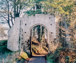
IN DECEMBER 2005, we spent a Saturday night at a bed and breakfast in a remote spot near Winchelsea in East Sussex. In those days we still had our own car and could stop where we wanted on or even off the route.One of our stopping places was Redhill in Surrey. We wanted to visit its contemporary Roman Catholic church of St Joseph and St Paul’s, but not for religious reasons. The architects, who had designed it, knew that my late uncle WS Rindl, an accomplished structural engineer, was a keen amateur sculptor. They asked him to make some decorative features and a crucifix to adorn the exterior of the church. In addition to the concrete crucifix, my uncle designed and constructed concrete gargoyles to run off rainwater from the roof. Each of these gargoyles is decorated in bas-relief with castings of the tools used by builders and engineers. On one of these drainage spouts there is a representation of what looks as if it were an early rather bulky model of a pocket calculator. The church, completed in 1984, is a lovely example of imaginative 20th century architecture, well worth a detour to see.The rurally located bed and breakfast was housed in a building that was at least 300 years old if not older. The accommodation was comfortable but the breakfast was disappointing. The fried eggs served seemed as if they had been made long before breakfast and kept warm; they were not as fresh as the frost that had coated the surrounding countryside overnight. We made a brief visit to Winchelsea, a place that has always fascinated me. Founded as ‘New Winchelsea’ by King Edward the First in the 13th century, the town was a coastal port, complete with city walls. By the 1520s, what had been a thriving centre of trade declined rapidly because of shifting of the coastline resulting from silting up of its harbour. Apart from some of the town’s mediaeval gateways and the large church of St Thomas the Martyr, it is difficult to imagine that Winchelsea was once a bustling metropolis. The decline of Winchelsea is one of many examples all over the world of how environmental changes can affect the ability of civilisations to thrive. In January 2020, we visited Lakhpat in Kutch, a part of Gujarat in western India. This huge walled city, far greater in size than Winchelsea, was a thriving seaport until the early 19th century when an earthquake caused the sea inlet on which it stood to become transformed into a salty desert. Today, the seven kilometres of intact city walls contain not a city but only a few widely separated dwellings and a Sikh Gurdwara. The church, which dates back to the 13th century, looks large. However, what can be seen today is all that is left of what had once been a far larger cathedral-like building.On the Sunday morning when we entered the church, a service was being held. There was the priest and his congregation of less than eight people, looking a little lost in the huge church. Seeing the three of us entering, he welcomed us, and said in a pleading voice:
“Do stay. Come and join us. You will help swell our numbers.”
This ancient church, although beautiful, was sadly unused in comparison to the modern one we had seen at Redhill.We could not stay for long because we had a prior arrangement to meet our friend Tony at the art deco De La Warr Pavilion at Bexhill on Sea. He had invited us to view an exhibition of 20th century furniture being held there. I was amazed to find that many examples of the kind of furniture my parents had bought in the 1950s and 1960s were now regarded as classics of design and commanded high prices at the sale. I remember that some of that furniture was comfortable and some it looked good but was uncomfortable. We revisited Bexhill on Sea recently to see an exhibition of works by the op-art artist Bridget Riley. We stayed in a lovely Airbnb near the pavilion. On this visit, we had time to wander around the town, a paradise for lovers of charity shops that raise money for good causes. Bexhill is also a popular town for retired people to live out the rest of their lives.Our Airbnb was next to one of Bexhill’s numerous charity shops. This particular store, which lay between our accommodation and the Pavilion, specialised in secondhand wheelchairs, walkers, bedpans, and Zimmer frames. I guess that there is a high turnover of such items in the town.

Press button A

A and B_240

When I  first became aware of public telephone boxes – that would have been in the early 1960s – they operated as follows. The caller first inserted a suitable number of coins, and then dialled. If the call was answered, the caller had to press a button marked ‘A’ in order to continue the call. By pressing this button, the inserted coins moved into the cash box. If, on the other hand, the recipient of the call did not answer or was busy on another call, the caller had to press button ‘B’. By doing so, the inserted coins were returned.

The A and B call boxes were later replaced by another system. The caller dialled the number. If it was answered, the caller heard a series of beeps. At this point, the caller had to insert money in order to remain connected. Many years after this newer system was installed, my father used to yell down the ‘phone:

“Press button ‘A'”

He did this despite the fact that button ‘A’ no longer existed.

Today, with the advent of mobile telephones, mastering the intricacies of operating public telephone boxes has become almost unneccessary.