Monkey Island

ROWERS AT THE 2012 Olympics would have become familiar with Dorney Lake. Built at great expense by Prime Minister Boris Johnson’s alma-mater, Eton College, this 1.4-mile-long waterway, a rowing lake, was ready for use by 2006. From the air, it looks like a long, wide airport runway filled with water. Prior to 2012, it was used for several international rowing competitions. In 2012, the lake was the site of both the Olympic and the Summer Paralympics. The lake continues to be used for rowing and members of public are allowed to use the parkland surrounding it when events are not taking place.

Monkey Island

We reached the outer fence of the rowing lake after crossing the elegant Summerleaze footbridge across the River Thames. It allows cyclists and pedestrians to travel between Bray (Berkshire) and Dorney (Buckinghamshire). The bridge takes its name from the company that built it in 1996. It was constructed originally to carry a gravel conveyor belt, which transported gravel from the construction site of the Dorney Lake across the river to the Summerleaze company’s gravel pits next to Monkey Island near to the village of Bray.

The view from the top of the footbridge is magical. The Thames flows briskly beneath it. Upstream the water flows around Monkey Island. Then it travels as a single stream beneath the bridge before being divided into two streams by another island a few yards downstream, Queen’s Eyot. On the chilly Saturday afternoon, when we crossed the bridge, several small cruisers and canoeists passed beneath us.  If you are lucky, and we were, you can see the towers and turrets of Windsor Castle in the distance on the south-eastern horizon.

Looking upstream and through the trees on Monkey Island, you can catch a glimpse of part of the Monkey Island Estate, currently a grand hotel built in and around a house with a fascinating history (www.monkeyislandestate.co.uk/pages/our-story.html).  Many people assume that Monkey Island is so-called because of the paintings of monkeys in one of the buildings on the island, but this is probably erroneous.  The name is most likely derived from the island’s earlier name ‘Monk’s Eyot’. The monks lived in Amersden Bank near Bray Lock on the Buckinghamshire side of the Thames. Their monastery, a cell of Merton Priory, was in existence by 1187, but was dissolved when Henry VIII put an end to such establishments.

The Great Fire of London of 1666 gave the area around Monkey Island a particular importance. For it was from here that Berkshire stone (for details, see: http://hanneyhistory.org.uk/wp-content/uploads/2018/08/Berkshire_Building_Stone_Atlas.pdf) was shipped down river to aid the reconstruction of London. Gravel from the damaged city was brought back upriver and dumped on and around Monkey Island. This resulted in both raising the level of the island to above flood level and providing a solid foundation upon which to construct buildings. Well, getting to know this was alone a good consequence of having crossed the Summerleaze bridge, but wait, there is more to follow.

An ancestor of the wartime Prime Minister, Winston Spencer Churchill, Charles Spencer, the 3rd Duke of Marlborough (1706-1758), purchased the island in about 1723. He had:

“…seen the property whilst attending meetings of the notorious Kit-Kat Club at nearby Down Place in Water Oakley. The Club which met from 1720 purported to be a gathering of ‘men of wit and pleasure about town’ but beneath a facade of joviality had more sinister objectives concerned with the defence of the House of Hanover.” (www.berkshirehistory.com/castles/monkey_island.html).

The Kit Kat Club, about which I have written before (https://adam-yamey-writes.com/2020/11/29/kit-kat-in-hampstead/) also used to meet at the Upper Flask pub in Hampstead Village.

The Duke had two buildings constructed on his recent purchase: a ‘fishing temple’ and a ‘fishing lodge’. The latter, constructed from wooden blocks that were cut to look like stone, still stands and is known as The Pavilion. Lady Hertford (1699-1754), Frances Seymour, later the Duchess of Somerset, writing in 1738, described the Pavilion as follows:

“He has a small house upon it, whose outside represents a farm – the inside what you please: for the parlour, which is the only room in it except the kitchen, is painted upon the ceiling in grotesque, with monkeys fishing, shooting etc., and its sides are hung with paper.”

The Monkey paintings, which still exist, were the work of a French artist Andien de Clermont (died 1783), who worked in England between about 1716 and 1756. Painted before 1738, they decorated the ceiling of what was once a banqueting room. It is now known as the ‘Monkey Room’.

By about 1840, the pavilion had become an inn, which could be reached by ferry from near Bray on the Berkshire side of the Thames. The hostelry became quite popular during the early 20th century, when its regular guests included King Edward VII and his immediate family. The authors HG Wells and Rebecca West enjoyed visiting the place. West makes many references to the island in her novel “The Return of the Soldier” (published in 1918). Here is an excerpt:

“So they went to Monkey Island, the utter difference of which was a healing, and settled down happily in its green silence. All the summer was lovely; quiet, kind people, schoolmasters who fished, men who wrote books, married couples who still loved solitude, used to come and stay in the bright little inn.”

In 1956, a footbridge was built from the Berkshire shore to the island. Additional accommodation was added to the original Pavilion in 1963 and then the inn became known as the ‘Monkey Island Hotel’. After a brief period of decline in the early 1980s, the hotel was restored and has become a successful luxury destination with a fine restaurant, which we have yet to sample.

Our friend who lives in Bray kindly introduced us to the Summerleaze footbridge from where we glimpsed the building on Monkey Island. She suspected that the place had an interesting history, and she was quite right. I will leave you with one more quote from Rebecca West’s novel, one which captured the atmosphere of the place well both when she wrote and today:

“…a private road that followed a line of noble poplars down to the ferry. Between two of them—he described it meticulously, as though it were of immense significance—there stood a white hawthorn. In front were the dark-green, glassy waters of an unvisited back-water, and beyond them a bright lawn set with many walnut-trees and a few great chestnuts, well lighted with their candles, and to the left of that a low, white house with a green dome rising in its middle, and a veranda with a roof of hammered iron that had gone verdigris-color with age and the Thames weather. This was the Monkey Island Inn. The third Duke of Marlborough had built it for a “folly,” and perching there with nothing but a line of walnut-trees and a fringe of lawn between it and the fast, full, shining Thames, it had an eighteenth-century grace and silliness.”

An old bridge on the moor

POSTBRIDGE IS A TINY SETTLEMENT in the middle of Dartmoor on the banks of the East Dart River, a tributary of the River Dart. The road that passes through the hamlet crosses the river over a venerable stone bridge (built in the 1720s). A few yards away from the bridge, there stands a far older bridge, a so-called ‘clapper bridge’.

The clapper bridge consists of four stone abutments (piers) spanned by three wide slabs of granite, each weighing about 6.5 to 8 tons. It is a simple but elegant structure, which has survived for many centuries. The bridge was most probably built to allow pack horses carrying tin to cross the stream on the way to Tavistock on the west side of Dartmoor. It was already in existence in the 13th century and is one of only 40 surviving examples of this kind of river crossing in the British Isles.

When we arrived at Postbridge during our journey from Cornwall to Somerset, the clapper bridge was crowded with camera-laden tourists who spoke German. Some of them were impolite, shouting at us rudely to get us to move off the clapper bridge so that they could get better photographs. Despite their uncultured behaviour, it was good to see that the bridge is still being used, albeit for leisure purposes. However, this is a far cry from what is depicted on a nearby pub sign: a horseman dressed in a red jacket riding his horse over the ancient bridge,

A bridge and a king


KINGSBRIDGE IS A SMALL town in South Devon. It lies at the head of an inlet of a ria (a completely submerged river valley) upon which the better-known and more popular resort of Salcombe is also located.

BLOG KING 3

 Many histories of Kingsbridge relate that the town resulted from the union of two neighbouring settlements, the neighbouring royal estates of Alvington and Chillington. Kingsbridge was formed around a bridge (possibly, a draw-bridge) that connected the two at the head of the inlet of the ria. The bridge was built by the 10th century. So far, so good, but today there is no bridge in the town of Kingsbridge.

If you drive from Kingsbridge towards Dartmouth via the A379 road, you will soon arrive at the New Bridge west of the town. This not so new bridge with five arches was built in 1845 and restored several times since then. It crosses Bowcombe Creek, another branch of the ria. This bridge is not, and has never, ben inside the town of Kingsbridge; it is well outside it. It is not, as has been suggested to me by several locals, the bridge that gave the town its name. So, where was the bridge?

By chance, I found a book about the history of Kingsbridge on-line. It is “Kingsbridge and its Surroundings” by SP Fox, published in 1874. This is the only source that I have found so far that mentions the site of the bridge in Kingsbridge. On page 10, the author noted:

“Nearly at the lower end, Fore Street is crossed at angles by Mill Street and Duc’c [now called Duke] Street, the former on the west side, leading to West Alvington and Salcombe; the latter on the east, in the direction of Totnes and Dartmouth, and uniting the towns of Kingsbridge and Dodbrooke by a very small bridge.”

The old bridge mentioned by Fox no longer exists, but the two streets mentioned do. Duke Street, which used to run through from Fore Street to Church Street near to the present Duke of Prussia pub (according to a late 19th century map), is now a cul-de-sac on which you can now find the main entrance to a popular fish and chips shop called ‘The Cod Father’. Mill Street is still a road leading towards West Alvington and Salcombe.

Where Fox describes the bridge, there is no sign of a ditch or stream today. Maybe, long ago there might have been a ditch or stream across which the bridge straddled. At the head of the inlet of the ria in Kingsbridge, there is a small arch, which might be the outlet to a formerly visible stream, which has long since been covered.

To add some complexity to the story, a modern source (https://kingsbridge.gov.uk/wp-content/uploads/2020/01/B13-Kingsbridge_Devon-Historic-Market-and-Coastal-Towns-Survey-Report.pdf) suggested that the bridge after which the town was named was not within the town itself but some way outside it:

“The exact site and function of the bridge is of great interest, as clear documentary evidence for an  Anglo-Saxon bridge in Devon is rare (Henderson and Jervoise 1938, 29; Hoskins 1954, 147), and, in the present context, because the development and character of the town, like its name, can be expected to have been fundamentally linked with that of the bridge and its highway. The attraction and shaping of urban growth to main roads and river crossings is a strong pattern across medieval Devon (Slater 1999). The detailed map analysis for the urban survey indicates that the early bridge may have crossed   the River – between routes later altered to become Love or Boon’s Lane on the west side, and Quay Street on the east – downstream from a tidal ford on the Mill Street-Duke Street route and below the extent of the medieval town…”

So, we cannot be certain of the location of the old bridge.

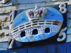
The coat of arms of Kingsbridge consists of a three-arched bridge surmounted by a royal crown. Whether or not the bridge had three arches is not at all certain, but the fact that it linked two royal estates justifies the presence of the crown. If the bridge was located where Fox believed, there was hardly enough width for a bridge with three arches.

But who was the king? It might well have been King Edgar, ‘The Peaceful’, who reigned from 959 to 975 AD. For, it was during his reign that a charter relating to boundaries dated 962 AD mentions the existence of a ‘king’s bridge’. That could also mean that the bridge was in existence before that king’s reign.

So, regardless of the actual position of the bridge after which Kingsbridge is named, we can be certain that the name is justified as there was a bridge somewhere in or near the town and it had royal connections. Whatever the origin of the name, the town of Kingsbridge is well worth a visit.

A narrow escape

IN AUGUST 2011, MY WIFE was invited to attend a Loreto House school reunion in Calcutta (Kolkata). As I had never been to the city before, I accompanied her. While my wife took part in the daily activities with some of her former schoolmates, I explored and fell in love with Calcutta.

Throughout our five day visit to the city, the monsoon rain fell heavily and incessantly. I walked around Calcutta, often wading through filthy water that submerged my feet and lapped around my ankles. This hardly affected my enjoyment of the delightful decaying city, in some respects India’s own distinctive version of old Havana in Cuba.

One day, I visited Jorasanko, the palatial residence of the Tagore family, whose members included not only the Nobel Prize winner Rabindranath but also artists such as Abanindranath and Gaganendranath.

After seeing around the fascinating rooms of Jorasanko, I sploshed through the flooded streets towards the Hooghly River. On my way, I walked along a busy street lined with shops and filled with crowds of people. A steady stream of rickshaws pulled by thin sinewy men and each laden with two or three passengers made its way through the busy throng. The huge wheels of these vehicles keep the passengers high above the water flooding the streets.

I noticed that some shops, often clothes and textile merchants, were giving hot food to some passersby. At one of these shops, I asked about the food distribution. It was explained to me that during Ramadan, it was considered to be a virtuous thing to feed the poor.

Eventually, after crossing a wide road clogged with slow moving heavy traffic, I stepped onto the Howrah Bridge, a gigantic steel bridge, a Meccano lovers dream, which traverses the River Hooghly. It was constructed between 1935 and early 1943.

At first, the bridge crosses over a large market that runs along the riverbank. Then, after a few yards, it is over the water. I walked along the downstream facing pedestrian walkway, dodging many porters carrying heavy and bulky loads on their heads. I took numerous photographs until I was two thirds of the way across the bridge and met a policeman with an ancient rifle slung over his back. Politely, he informed me that photography was forbidden on the bridge. By then, I had sufficient images stored in the memory of my camera.

Once over the river, I headed through the streaming rain and thick crowds to a boat station close to the Howrah railway terminus. My plan was to travel on a river bus downstream to a landing stage not far from Park Street.

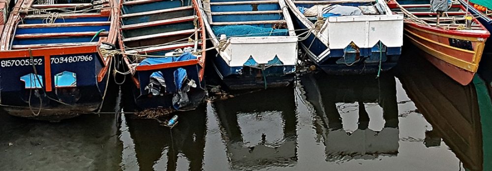
I bought a ticket which was printed on very poor quality paper, that had to be kept dry to avoid it falling to pieces. I asked someone on the floating platform at the water’s edge if the boat that was approaching was heading for my planned destination. I received what I believed was an affirmative reply, and then boarded a relatively empty boat with plenty of free seats. We set off.

To my surprise, the boat headed upstream rather than downstream. Soon, we passed beneath the Howrah Bridge. We sailed a long way upstream away from the city centre. The banks of the river were lined with unattractive industrial buildings and these were punctuated by occasional bathing ghats.

I disembarked at the boat’s first stop. Had it not been raining so heavily, I would have exited the boat station to take a look around the area. Instead, I bought another flimsy ticket to return to Howrah. This time, I asked several people at which of the two floating embarkation pontoons I should board the downstream boat. I waited close to the water while a large crowd of fellow passengers gathered behind me. I wanted to be sure of embarking first.

The boat approached where we were all standing. I could see from afar that it was packed to the gills with people. When the boat was about 18 inches away from the pontoon, I felt a great push from behind me and I was catapulted across the water towards the approaching vessel. Luckily, I was able to grab something on the boat and this saved me from falling into the water and being crushed between the boat and the pontoon.

The boat was stuffed with people. I am sure that sardines are less tightly packed in tins. I wanted to try to take a photograph to capture an image of this crowd, but I could not because so great was the pressure exerted by those around me that I was unable to raise my hands from beside my body.

I looked around and noticed there were few life saving flotation items. Had our boat sunk, few on board would have survived.

It was a great relief to disembark at Howrah. I was drenched, somewhat shaken, and hungry. I decided to take a taxi to Flurys in Park Street, a European style tea room that served what I was yearning at that moment: toasted club sandwiches.

I boarded a battered yellow Ambassador taxi in a car park near the railway station. We moved forward into a mass of other similar taxis. The crowded taxis were so close to each other that it felt that they were all welded together. It took almost an hour for my driver to skilfully manoeuvre his taxi a couple of hundred yards on to the bridge.

At last, we arrived at Park Street, where, slightly drier because of sitting for ages in the taxi, I settled down at a table in Flurys. I ordered my sandwich and savoured the peaceful atmosphere in the tea room.

On my third visit to Calcutta at the end of 2019, we visited Flurys but, sadly, we were disappointed to find that its food and service was no longer as good as before. Fortunately, the scruffy Nizams at New Market, which serves parathas stuffed with meat and omelettes, remains as good as it was in 2011 and many years before.

Despite my near escape from severe injury or worse, my enthusiasm for Calcutta and its people continues to grow and grow.