KENSINGTON GARDENS CONTAINS numerous works of art, one of which is a large piece by Henry Moore (1898-1986), a sculptor who is highly regarded by many people. It is a large irregularly shaped arch made of travertine, which stands overlooking the Long Water, the part of the Serpentine lake within the confines of Kensington Gardens. Presented by the artist to the park in 1980, its shape is based on that of an animal bone. I am not wild about Moore’s works, but this piece looks wonderful in its setting on the eastern bank of the Long Water.
Today, 19th of May 2021, whilst walking in Kensington Gardens I saw a heron standing on the western bank of the Long Water almost framed by the Moore arch. After circumnavigating the lake, we reached the point on the eastern shore where the sculpture stands. Through the archway you can see the eastern façade of Kensington Palace. Along the line that connects the palace and the sculpture, you can see another sculpture, “Physical Energy” by George Frederick Watts (1817-1904). The three items on this axis form a kind of timeline: the 18th century palace, the 19th century sculpture by Watts, and the 20th century sculpture by Moore.
I have walked past the Moore sculpture too many times to count, but it was only today that I saw a heron perched on top of it. I have seen geese and pigeons perched on it in the past, but this was the first time I saw a heron using it as a doubtless superb vantage point to survey its surroundings. Apart from the fact that I find herons beautiful, its close association with the sculpture struck a certain curious chord in my mind. Maybe, it was something to do with the fact that the words ‘heron’ and ‘henry’ share so many letters in common (3 out of 5). Whatever the reason, it was pleasing to see nature and art intimately in touch with each other.
IN A COUNTRY SUCH AS ENGLAND, the profusion of sundials seems almost ironic given how often the sky is grey and the sun is hidden. Since the year 2000, the average monthly sunshine ranges from less than 50 hours to a little over 250 hours per month (https://www.statista.com/statistics/584898/monthly-hours-of-sunlight-in-uk/), the variation reflecting the different seasons of the year. The average number of daylight hours varies from 8 in January to 16.5 in July (http://projectbritain.com/weather/sunshine.htm). Using these figures and a bit of basic arithmetic, one can estimate that there is sunshine for about 20% of the daylight hours on an average January day, and about 89% of the daylight hours on an average July day. Roughly speaking, a sundial, which can only be of use when the sun is shining, is likely to be helpful for telling the time in England between 20% and 89% of daylight hours on an average day. Nevertheless, there is a great number of these partially usable timepieces in existence in gardens and on buildings in England. The figures I have calculated make the words of my opening sentence only slightly less drastic than they seem. Yet, relying on sundials as timepieces is, as my wife pointed out, a good interpretation of the words of Samuel Johnson (1709-1784), quoted by his biographer James Boswell (1740-1795):
“The triumph of hope over experience.”
This was not said in relation to sundials, but to:
In other words, enjoy the sight of sundials in their many shapes and sizes but do not become wedded to them if knowing the time is of importance to you.
SOME OF LIFE’S PLEASURES are seasonal. Such is the case for the explosion of colour that can be seen in the Isabella Plantation in London’s Richmond Park. During late April and most of May, the azaleas and rhododendrons in the Isabella burst into flower. These alongside many other flowering plants, including seas of bluebells, provide a sumptuous banquet of colour for the visitors’ eyes. It is not so much the immense number of flowers that provides so much joy but the way the shrubs and other plants have been planted that creates a visual experience that easily rivals the best of fireworks displays. Even if I were able to express myself better in writing, words cannot possibly recreate the experience of seeing the Isabella Plantation in full bloom. Although I am keen on photography, I feel that even good photographs of the place can only hint at the impact of seeing the flora in real life. In brief, if you can, you must try to visit the plantation when the blooms are at their most magnificent.
The Plantation is in the southwest part of Richmond Park, not far from both the Robin Hood and Kingston Gates. The latter is open to motor traffic currently (May 2021). Richmond Park was a royal deer park, a hunting ground, established by the 14th century when it was part of the Manor of Sheen (https://historicengland.org.uk/listing/the-list/list-entry/1000828). King Henry VII was particularly fond of the park, which he named ‘Richmond’ after his earldom in Yorkshire (Richmond is a town in that county). He also had a palace built there, of which precious little remains because by the Restoration of the Monarchy in 1660, it was already dilapidated and was never rebuilt. In its heyday, it was one of the few places fitted with a flushing lavatory. This was installed by Queen Elizabeth I’s godson, Sir John Harington (baptised 1560- died 1612; https://en.wikipedia.org/wiki/John_Harington_(writer)).
The history of public access to the park is of interest (www.trpg.org.uk/perch/resources/newsletter-005.pdf). Between 1637 when King Charles I enclosed the park and the 1730s when Robert Walpole forbade it, there was pedestrian access to the park. In 1758, a certain John Lewis (1713-1792) won a court case that re-established the right of some public access to the paths and roadways within the park. By the mid-19th century, the public could drive their carriages through it. Today, its roadways are popular both with cyclists and motorists.
The history of the Isabella Plantation is detailed on the website of The Royal Parks (www.royalparks.org.uk/), from which I obtained the following information. By the 17th century, the waterlogged area in the south west corner of Richmond Park was known as ‘The Sleyt’, a sleyt being a word for boggy ground or an open space between woods and banks. The area where the Plantation is today was marked as ‘Isabella Slade’ on maps published by 1771. The name Isabella either referred to a lady with that name, or, more likely, it was a corruption of the word ‘isabel’, which as far back as the 15th century meant ‘dingy’ or ‘greyish yellow’, which is the colour of the soil in the area of the park where the Plantation is located.
A Deputy Park Ranger, Henry Addington, Lord Sidmouth (1757-1844), fenced off an area of 42 acres of the Isabella Slade in 1831, planted various kinds of trees for timber, and gave the land its present name, ‘Isabella Plantation’. Sidmouth, a Tory politician, was briefly Prime Minister at the beginning of the 19th century, lived in the White Lodge of Richmond Park from 1801 until his death (https://whitelodgetimeline.royalballetschool.org.uk/1800/item/161/). He had been given it as a residence by King George III, who appointed himself the park’s Ranger and Sidmouth his Deputy. Currently, the White Lodge houses The Royal Ballet school.
Getting back to the Plantation as we see it today, it was created chiefly by the work of the Park Superintendent, George Thomson, done between 1951 and 1971. The Royal Parks website explains that:
“The present garden of clearings, ponds and streams was established from the 1950s onwards. It is largely the work of George Thomson, the park superintendent from 1951-1971. Along with his head gardener, Wally Miller, he removed Rhododendron ponticum from large areas and replaced it with other rhododendron species. They established evergreen Kurume Azaleas around the Still Pond and planted other exotic shrub and tree species.”
The Plantation has three ponds, of which the Still Pond is the most spectacular. Surrounded by azaleas and Rhododendrons, its waters are still, that is they are mirror-like. The flowers of the shrubs surrounding the water are reflected in the water, producing a delightful and dramatic visual effect. The other ponds, Peg’s Pond, and one named after Thomson, have their own charms but lack the drama of the Still Pond. Streams and rivulets lined with ferns and other plants flows across the Plantation. The longest stream was dug in 1960 and includes Peg’s Pond.
So far, we have visited the Isabella Plantation three times. Twice, we saw it in its full floral glory and once a few months before the flowering began. Timing is important if you want to enjoy the full floral impact. So, get there in late April or during the first few weeks of May in order to best experience the forms, colours, and fragrances of this beautiful collection of flowering shrubs.
A FRIEND INVITED us to dine one evening at the exclusive Mosimann’s Club in West Halkin Street in London’s elegant Belgravia district. As it was dark when we arrived and I was too busy chatting with our host, I failed to notice the exterior of the establishment. Years later, I noticed that the narrow façade of this fancy eatery, named ‘The Belfry’, is that of a Victorian gothic church with a slender spire.
The church was being used by the Presbyterians in 1866, so wrote Edward Walford in the 1880s. The website of The London Metropolitan Archives catalogue reveals more:
“…a chapel was built on Lower George Street, called the Ranelagh Chapel. In 1845, on the death of the Methodist minister, the church joined the English Presbyterian Church and was renamed Ranelagh Presbyterian Church. The lease on the Lower George Street chapel expired in 1866 and the church merged with a Presbyterian Mission in West Halkin Street, Belgrave Square. The name Belgrave Presbyterian Church was adopted. The church was rebuilt in 1881. In 1923 the church moved to premises in Emperor’s Gate, Kensington.”
The former church is an unusual structure in that the end facing the entrance is considerably wider than the façade. As to when it was originally built, I am uncertain. Nikolaus Pevsner, the architectural historian, does not give it a mention in his extremely detailed guide to the buildings of the City of Westminster in which it is located. However, he does mention the chapel’s neighbour, to the left of it as you face the façade. Far more attractive than the chapel is the façade of its neighbour which is decorated in a neoclassical style. It has two porticos supported by pillars with Doric capitals. This building was built in about 1830.
Today, the Doric pillars flank entrances to a branch of Waitrose food stores. This shop also has an entrance on the street parallel to West Halkin Street, Motcombe Street. Thus, two temples of food stand side by side. If you cannot afford to dine in the former church, then you can console yourself and appease your appetite by acquiring something edible in Waitrose by stepping between the Doric pillars. In case you are wondering what we ate at Mosimann’s, I am afraid I cannot recall as it was so long ago, but I do remember enjoying it.
IF YOUR TRAIN FROM CAMBRIDGE to London stops at Shepreth and Meldreth, you can be sure that you are in for a longish journey because only the slower trains halt at these stations. Over the course of many years, we have been travelling to and from Cambridge by train and as I enjoy looking out of the window, I have always noticed this pair of oddly named stations. Only recently, we visited both places by car and took a look around these lovely villages between Cambridge and Royston and close to the A10 road, which runs from London Bridge to Kings Lynn via Cambridge.
The ‘reth’ suffix in the two villages names means ‘stream’. Shepreth means ‘sheep stream’ and Meldreth means ‘mill stream’. There is archaeological evidence of settlements in both places long before the Romans invaded England. The Romans may have occupied part of the parish of Shepreth and their successors, the Saxons, developed the village of Meldreth. Both villages are listed in the Domesday Book (1086). Little appears to have been recorded in the history books about events in tiny Shepreth. The larger village of Meldreth also played no great role in the history of England but, in the 16th century, Christ College of Cambridge moved to its estate near the village to escape from the plague. Members of the Meldreth Local History Group might disagree with my assessment of Meldreth’s place in British history. Their superb website (meldrethhistory.org.uk/) details many aspects of the place’s past, but most of them are about the village rather than the wider world.
I imagine that the building and opening of railway stations in the two villages in 1851 were major events in their history and development. Currently, the stations are served by Thameslink trains. The villages are popular places for commuters to both London and Cambridge.
Both villages are rich in historic buildings of great beauty. Many features of vernacular architecture can be found including many fine thatched roofs. A particularly charming old, thatched edifice In Shepreth is Corner Cottage, which is close to a more aristocratic looking building, Docwra House. This former manor house was built in the 17th century and then provided with later additions (www.docwrasmanorgarden.co.uk/history.htm). The village sign at Shepreth is suitably adorned with sheep, bales of fleece, a stream, a bridge, a water mill, and a leaping fish. The bridge, which we did not see, was built in the 17th century. It crossed the River Rhee, a tributary of the River Cam, in which sheep were washed, and was used by farmers taking sheep to the market in Cambridge.
At Meldreth, through which flows the tiny River Mel, a tributary of the Cam, we entered the parish church of Holy Trinity, whose construction began in the mid-12th century on the site of an 8th century church. Its square tower, nave, and chancel were all constructed in the 12th century. The church contains some fine brass chandeliers; an elaborately carved pulpit and choir stalls with wooden carvings; fragments of pre-Reformation frescoes; a lovely timber beam ceiling; some heavily whitewashed carvings supporting some of the ceiling timbers; and a mediaeval parish chest. The latter is one of about 150 surviving examples. It was made in Baltic pine with iron bands between about 1400 and 1420 and was used for securely storing valuable liturgical items (e.g., silverware, books, and vestments). In addition to visiting the church, we drove through long village to its station, which up until our visit by car, we had only ever seen whilst speeding through it by train. However, we did not see any mills as suggested by the meaning of the name Meldreth.
We did not spend nearly enough time in the two villages as we fitted them into an already busy day of sightseeing. However, having sampled them, we feel that they merit a longer visit in the future. Once again, these places provide good examples of the wealth of historical features to be discovered in England’s rural areas.
BEFORE THE ADVENT of railways, transportation of goods across England (as well as Wales and Scotland) was heavily dependent on an extensive canal system constructed mostly in the 18th and early 19th centuries. Freight was carried along these canals in the holds of long narrow barges, more correctly known known as ‘narrow boats’. They had to be narrow enough to negotiate some of the narrower canals that formed part of the canal network. Prior to the development of steam and other kinds of engines, and even for some years after these became available, the narrow boats were towed by horses. These creatures walked along paths known as ‘towpaths’ that run along one or other side of a canal, except when a canal passed through a tunnel. In the tunnels there were no towpaths, and the boats were propelled by the feet of men lying either above the load on the boat or sometimes on planks projecting from the sides of the vessel, a process known as ‘legging’. The boatmen’s feet literally walked along the tunnel walls, thus moving the boat. Meanwhile, the towing horses walked over the hill through which the tunnel passed. All of this interesting but becomes even more so if you can experience a trip on a canal in a narrow boat.
Several companies offer canal trips between Little Venice (near London’s Paddington) and Camden Lock, east of it. We chose to travel on “Jason”, a narrow boat built in 1906 and one of the last of its era, which is still in use. “Jason” has been little modified compared to others that ply the route along the Regents Canal, a branch of the Grand Union Canal system. “Jason”, which was originally horse-drawn, has been fitted with a diesel engine that occupies part of the small rear located cabin that was once the home to a boatman and his family. Passengers sit in the long, narrow freight hold of the boat under an awning that was added when “Jason” was converted from a freight carrier to a tourist vessel, which has been doing the tours since 1951. Unlike most of the other tourist boats, there are no windows separating passengers from the exterior. This provides for great viewing along the route without the hindrance of sometimes not too clean glass, which might be encountered in other vessels.
The tour starts from a landing stage next to Blomfield Road, close to the cast-iron bridge that carries Westbourne Terrace Road over the Paddington Arm of the Grand Union Canal. At the other end of the trip, passengers disembark or embark next to the popular (not with me) and rather ‘tacky’ Camden Lock Market. The cruise between the two landing stages takes 45 minutes and is highly enjoyable. Travelling eastwards from Little Venice, we were given an extremely clear and intelligent commentary by a lady called Sarah. Various things she told us made a strong impression on me.
The Regents Canal that links Paddington Basin to Limehouse Basin in east London, where it leads to other canals, used to carry a wide range of goods, from coal to cocoa. The waterway passes under both rail and road bridges. Many of the latter have curved arches over the canal; are made of stone; and look older than the rail bridges, most of which have rectangular arches with roofs consisting of metal plates screwed together. Over the years, the tow ropes drawing the narrow boats have cut grooves or notches in the corners of the bridges next to the towpath. Some of the bridges have been protected from this damage by iron brackets placed so that the ropes passed over these instead of the masonry of the bridge. These metal protectors, which were easily replaceable, can now be seen to be notched where the ropes have abraded them.
“Jason”, like most other narrow boats, has a flat bottom and a shallow draught. This is because the water most of the canal system is quite shallow, usually not more than 6 feet deep. The bottom of “Jason” is made of wood (probably elm) and iron, a combination known as a ‘composite’ construction. Few narrow boats with this kind of construction exist today.
The most fascinating thing that Sarah told us related to the history of Lord’s Cricket Ground. In 1787, Thomas Lord (1755-1832), a professional cricket player, opened his first cricket ground in what is now Dorset Square (close to Baker Street Underground station). In 1809, Lord shifted his cricket ground to another location because the rent at his Dorset Square site became too high. The new location was on some disused ground just south of the present Lord’s Cricket Ground. It was where today the Regents Canal emerges from the eastern end of the 272-yard-long Maida Hill Tunnel. Let me explain.
In 1813, Parliament altered the route of the proposed Regents Canal so that it passed right through Mr Lord’s recently relocated cricket ground (www.lords.org/lords/our-history/timeline). Mr Lord was unhappy about this and was not prepared to give up his ground without first going to court. According to our guide, Lord struck a deal with the government. He agreed to move to a new site providing he was given all the earth that was excavated during the construction of the Maida Hill Tunnel. He used the vast amount of excavated earth to lay out the ground on which the present Lord’s Cricket pitches are now located.
Concerning construction, Sarah told us that not only had the tunnels been dug by hand, but also the entire canal system. Most of the manual workers were Irish and were known as ‘navigational engineers’, or ‘navvies’ for short. The base of the Regents Canal is lined with compressed clay to make it watertight, a difficult process when the canal was built.
The cruise between Little Venice and Camden passes through a variety of landscapes, ranging from disused industrial to almost bucolic. The canal passes through the northern edge of Regents Park, where it is lined with trees and parkland. In this stretch of the canal, it is difficult to believe one is in the middle of a huge metropolis and not in the deep countryside. The waterway also passes through the London Zoo. On one side, if you are lucky, you can catch glimpses of African hunting dogs and the occasional warthog in their cages overlooking the canal. Opposite them on the northern bank of the canal is Lord Snowdon’s aviary, now devoid of birds and awaiting a new purpose.
The 45-minute cruise provides an enchanting view of several districts of London. The commentary provided by Sarah and what she pointed out along the route helps recreate in one’s mind the golden age of canal transport. We enjoyed the cruise in both directions and hope that many others will take advantage of the special experience that it provides. For booking details and other practical information, consult “Jason’s” website: www.jasons.co.uk/the-tour
KEEN READERS OF NOVELS by Georgette Heyer (1902-1974) will have come across the name ‘Hitchin’ in several of her stories. For example, in “The Foundling”, Belinda sighs, and then says:
“She went to a place called Hitchin, but I don’t know where it is, and I only recall it because it sounds like kitchen, and I think that is very droll, don’t you, sir?”
She receives the reply:
“But Hitchin lies only a few miles from here! I daresay no more than six or seven, perhaps not as much! If you think you would like to visit this friend, I will take you there tomorrow! Do you know her direction?”
Later in the story, there are frequent mentions of Hitchin and a ‘Sun Inn’ in the town. There used to be an inn with that name on Sun Street, where currently, there is a Sun Hotel. In another novel, “The Reluctant Widow”, Hitchin is the name of the landlord of an inn, ‘The Bull’ in Wisborough Green, a village in West Sussex.
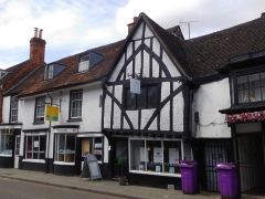
Old world in central Hitchin
It is only in recent years that I have begun to read the wonderfully crafted historical novels by Heyer, but I was aware of Hitchin even as a young child. In those now far-off days, when I lived near Golders Green in north London, I was a collector of bus and train maps and an enthusiastic observer of buses. One of the buses that passed through Golders Green and along Finchley Road was the Green Line route number 716 that travelled all the way from Chertsey in southwest London to … you have probably guessed … Hitchin, far north of London in Hertfordshire. It was only today (11th of May 2021) that I finally got to visit Hitchin. I had read that it has a picturesque historic town centre and what we found surpassed all expectations.
A 7th century document states that Hitchin was the centre of the Hicce people, ‘hicce’ being Old English for ‘the people of the horse’. By 1086, when the Domesday Book was compiled, Hitchin was described as a ‘Royal Manor’. The town’s name is also associated with the River Hiz (pronounced ‘hitch’ by some), a short stretch of which flows in front of the eastern end of the centrally located St Mary’s Church, which is mostly 15th century with an 11th century tower. Later, the town thrived because of the wool trade; vellum and parchment making; tanning; rope-making; malting; and its coaching inns, such as that mentioned in Heyer’s novel. Hitchin was a staging post for coaches travelling between London and what road signs in the south of England call ‘The North’. The town is not far from the current A1 trunk road. Many of the inns have long since closed, but their picturesque buildings, most of which look mediaeval, or at least pre-Georgian, still stand and can often be identified by the large archways leading from the street into yards behind them. Grain trading was another important activity in the town. Its former Corn Exchange still stands in the Market Square, but its use is no longer what it was built for.
Despite the 20th century improvements in transport links to London, making Hitchin into a convenient place for commuters, the historic town centre contains a remarkably high number of old buildings lining its mediaeval street lay-out. These old throughfares surround the lovely, large Market Square, which like many towns and cities in mainland Europe, was filled with tables and chairs for people to enjoy refreshments from the many eateries that surround it. A covered arcade leads off the square and provides a weather-proof place for refreshments. Nearby, there is a modern market area with stalls with conical roofs. We were fortunate to have arrived on a day, Tuesday, when this market is working.
Our first impression of Hitchin was extremely favourable, but because we had planned to do so much more sightseeing that day, we did not spend nearly enough time there. We hope to revisit this place again soon. I can strongly recommend the Hitchin to anyone who wants to get a flavour of ‘Ye Olde England’ without having to travel too far from London.