Unknown's avatar

About yamey

Active author and retired dentist. You can discover my books by visiting my website www.adamyamey.co.uk .

A lost landmark and a treasured map

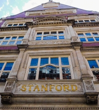
EVER SINCE I CAN REMEMBER, I have been fascinated by maps and collected them. I cannot say exactly why I enjoy them, but one reason is that I get satisfaction from aesthetic aspects of cartography. Another reason is that when I look at them, I try to imagine the reality that they represent, a form of virtual travelling. Whatever the underlying cause(s) of my fascination with maps might be, it is irrelevant to what follows because what I want to tell you is about a shop that I used to love to visit. It was Stanford in London’s Long Acre, a street not far from the old Covent Garden Market and Leicester Square.

Founded by Edward Stanford (1827-1904) in the early 1850s, his business was one of the best specialist suppliers of maps in the UK, if not the very best.  His company’s store on Long Acre opened in 1901, having moved there from Charing Cross. When I used to visit the shop to browse the lovely maps on display in the 1960s, there were two floors open to the public. The ground floor was the main showroom with maps of popular destinations that appealed to the majority of customers. The basement was less attractively arranged but far more interesting to serious travellers and map collectors such as me. There were no maps out on display down there. One had to ask a salesman to show you maps of areas that interested you. I believe it was there that I bought a nautical chart of the extremely remote French island of Kerguelen in the southern part of the Indian Ocean, a place that I had no intention of ever visiting.

In about 1966, my interest in Albania was born. I have tried to explain why this happened in my book “Albania on My Mind”, which I published in 2013, 101 years after Albania gained its independence.   In those days, not much was known in the UK about this small country in the western Balkans. Maps of Albania were not available in most shops, probably because few people visited the place, or were even remotely interested in it. So, I took the Underground from my local station, Golders Green, to Leicester Square. Stanford was a few yards from that station. At Stanford, I enquired about detailed maps of Albania, and was sent to the specialist map department in the basement.

The only detailed map of Albania available at Stanford was a 1:200,000 scale map with the information that it was made:

“Auf Grund der Oesterreichischer-Ungarische Kriegsaufnahmen und der im Auftrage der Albanische Regierung Von Dr Herbert Louis gemachten aufnahmen sowie mit Benützung italienischer und franzoesischer Karten” (i.e., ‘On the basis of the Austrian-Hungarian war recordings and the recordings made by Dr Herbert Louis on behalf of the Albanian government, as well as with the use of Italian and French maps’)

The map, which comes as two sheets, was up to date in 1925. A small map alongside the main map shows which parts of the large map were surveyed by whom and when.        Between 1916 and 1918, the surveyors were the armies of Austria-Hungary, France, and Italy. Some information collected by Baron Nopcsa between 1905 and 1909 is included in the map, as well as data collected by Dr H Louis between 1923 and 1924.

Baron Nopcsa was the Hungarian aristocrat and politician Franz Nopcsa von Felső-Szilvás (1877-1933; see: http://www.smithsonianmag.com/history/history-forgot-rogue-aristocrat-discovered-dinosaurs-died-penniless-180959504/), a founder of paleobiology and a specialist on Albanian studies. This one-time candidate for the throne of Albania created the first geological map of northern Albania. The German Dr Herbert Louis (1900-1985), whose name is prominent on the map, was no stranger to Albania. In 1923, he accompanied the Austrian geologist Ernst Nowack (1891-1946) during his research in the country, and in 1925, he was awarded a doctorate for his studies concerning Albania.

The map looked beautiful, I fell in love with it, and I knew I had to obtain a copy of it, but it was priced at 23/- (23 shillings: £1.15) for the set. That might not sound excessive today in 2021, barely the price of a small bar of chocolate or a cup of tea (in a scruffy café). But in about 1966, it was a huge sum of money for me, many times more than my weekly pocket money. I left Stanford, determined to save up for it and hoping that in the meantime the shop would not run out of copies of it. Eventually, I was able to purchase a set of these maps.

Delicately drawn, covered with contour lines, shaded representations of rocks and mountains, a variety of colours, the map shows how few roads there were in Albania in the 1920s. The tiny black dots, which represented buildings or small groups of them are often shown to be connected by tracks or footpaths, but many of them are a long way from any line of communication marked by the map makers. Most of the names on the map are in Albanian, but a few are also in Italian (e.g., Durazzo [Durres], Valona [Vlora], San Giovanni di Medua [Shengjin], and Santi Quaranta [Saranda]). Some words on the map are also in German.

I treasure this set of maps I bought at Stanford so many years ago and my memory of first being shown them in the basement of the shop. Yesterday, on the 15th of August 2021, first day of the 75th year of India’s independence, we walked along Long Acre, and discovered that although its name on the building is still there, the map shop is not. I had not realised that in 2019 this repository of records of landmarks and one of my favourite childhood haunts had moved from Long Acre to nearby Mercer Walk near The Seven Dials.

Poetry on a wall

Yesterday, Sunday the 15th of August 2021, we noticed an attractive wall painting not far from the large Liberty shop on Great Marlborough Street. It is the Soho Mural in Noel Street, the eastern continuation of Great Marlborough Street. With the title “Ode to the West Wind”, it was created in 1989 by Louise Vines and The London wall Mural Group, whose telephone number (on the circular blue patch) was then 01 737 4948 (now, the number would begin with 0207 instead of 01).

More information about this mural and its quote from the poet Percy Bysshe Shelley can be found at http://londonmuralpreservationsociety.com/…/ode-west-wind/

After Armageddon? An art installation

ORFORD NESS IS a desolate strip of land on the Suffolk coast. Separated from the rest of the county by the lower reaches of the River Alde, it was used for testing military technology during much of the 20th century. While it was in the hands of the military, it was strictly out of bounds for everyone except those who were authorised to be there. It was a highly secret military area, more about which I plan to write soon.


In the early 1990s, the Ness was handed over to the National Trust, who developed it and the decaying remains of the military establishment as a visitor attraction and nature reserve.
This Summer (2021), an organisation called Artangel, who “…collaborate with artists who defy boundaries to give form to extraordinary ideas,” (www.artangel.org.uk/about_us/), have placed several intriguing art installations on Orford Ness. One of these, which I particularly liked, is called “The Residents”. It was created by Tatiana Trouvé, who was born in Calabria and grew up in Dakar, Senegal.


Her installation is housed in a concrete structure half buried in shingle and called Lab 1. It was in this bunker, built in the 1960s, that detonators for Britain’s atomic bombs were tested for their resistance to vibration and other forces that might set off detonators at inappropriate times, for example, when being carried in aircraft.


Like most of the rest of the deserted military establishment on Orford Ness, Trouvé’s collection of objects in the disused, dilapidated bunker, creates an intense feeling of a post-Armageddon world. The artist populates the space with a variety of objects, such as suitcases, cloth bags, books, quilted mattresses and rugs, and a transistor radio. All of these objects look as if they have been discarded by people fleeing an horrific disaster. All of them are painted to look life-like, but none of them are real; they are all cast in either aluminium or bronze. This is also the case for the life-like seashells attached to the gate through which the observer looks at this created scene of despair.


Surrounded by acres of shingle covered with distorted, rusting fragments of metal and discarded lumps of concrete, the installation housed within Lab 1 gave me the feeling that I was being given a glimpse of what I hope never to experience: the world following a nuclear catastrophe.

Drums in Afghanistan

RUDYARD KIPLING PUBLISHED his story “Drums of the Fore and Aft” in 1889 (www.kiplingsociety.co.uk/rg_foreandaft1.htm). Based on an incident that occurred in the Second Afghan War (1878-1890), most likely during a battle at Ahmed Khel in 1880, his tale includes the story of two drummer boys, who, fortified with rum and courage, march up and down the battlefield playing the tune of the song, “The British Grenadiers”, which, incidentally, we used to sing at school in the early 1960s. Although the British defeat their enemy, the boys are killed.  Well, I doubt that I would have ever known about this story had we not recently visited Woodbridge on the backwaters of the coast of Suffolk.

Much of Woodbridge is located on the slope of a hill. Its picturesque Market Hill is high up on this incline. It contains many buildings that have been in existence for several centuries. In the centre of the square, stands the Shire Hall, a rectangular brick building with stone trimmings and gables at both ends of its roof. The gables give the building a somewhat Dutch appearance. The edifice is believed to have been built in about 1575 by a local worthy, a politician and member of the court of Queen Elizabeth I, Thomas Seckford (1515-1587). Since then, it has been modified a little, but not to its detriment.

Just outside the eastern end of the Shire Hall, we found a sculpture depicting two young soldiers. One is standing, beating a drum, and the other is sitting on the floor looking upward, a discarded bugle at his feet. A plaque next to the sculpture reads as follows:

“’Drums to the Fore and Aft’. Gifted to the Town by the Duchess of Albermarle following her husband’s wishes in January 1980. Sculpted by Arnold, 8th Earl of Albermarle. Re-sited to this position in March 2018.”

When I saw this, I wondered about the aristocratic creator of this lifelike sculptor.

Arnold was Arnold Allan Cecil Keppel, 8th Earl of Albemarle (1858-1942), soldier, courtier, and Conservative politician (https://en.wikipedia.org/wiki/Arnold_Keppel,_8th_Earl_of_Albemarle). Educated at Eton College, he fought in the 2nd Anglo-Boer War (1899-1902) after having been an MP for Birkenhead between 1892 and 1894. On becoming the 8th Earl, he took his late father’s place in the House of Lords. His wife was born Lady Gertrude Lucia (1861-1943). As she died in 1943 and the town only received the sculpture in 1980, it seems to have taken a long time for her late husband’s wishes to be fulfilled. At least that is what I thought until I looked into the story behind this work of art.

As for the sculpture in Woodbridge, Wikipedia includes the following about Arnold Keppel’s relationship with it:

“He is credited with sculpting the statue of the two drummer boys from Rudyard Kipling’s story ‘The Drums of the Fore and Aft’ that now stands in Woodbridge, Suffolk.”

The Recording Archive for Public Sculpture in Norfolk & Suffolk, a database of sculptural works within the two counties, has the following information about the sculpture (http://racns.co.uk/sculptures.asp?action=getsurvey&id=373):

“8th Earl of Albemarle Sculptor(s). Private commission by 8th Earl of Albemarle. 1901, the cast may be later since the foundry only adopted the name A.B.Burton in 1902, after the death of the other partner, A.J. Hollinshead.”

An illustration in the Archive’s website shows a plaque, which I did not see. This provides the information that the sculpture was given to the town in January 1980 in memory of Walter Keppel, the 9th Earl of Albermarle (1882-1979). Another photograph shows that the sculpture is signed “Albermarle 01”. ‘Albermarle’ was Walter’s father, and ‘01’ refers to 1901. Having learned all of this, I now realise that the sentence I read on the plaque, “Gifted to the Town by the Duchess of Albermarle following her husband’s wishes in January 1980.”, refers not to the 8th Earl’s widow, but to the widow of his son, Walter.

The sculpture is well executed, showing that its maker was a competent artist. A search of the Internet revealed that in addition to the sculpture in Woodbridge, he also drew portraits (e.g. https://auctions.roseberys.co.uk/m/lot-details/index/catalog/299/lot/116339?uact=5&aid=299&lid=116340&current_page=0). Otherwise, I can find hardly anything else about his artistic output. That said, if the sculpture in Woodbridge is the only example of his modelling, it is something that the late 8th Earl must been pleased with.

Locked in a church overnight

THE BATTLE OF NASEBY was fought on the 14th of June 1645 between the Royalists, led by King Charles I and his nephew Prince Rupert of the Rhine, and the Parliamentarians, led by Sir Thomas Fairfax and Oliver Cromwell. It was a victory for the Parliamentarians and the last major battle in the (First) English Civil War (1642-1646), putting an end to any hopes that the king had of winning the conflict. The battlefield at Naseby is about 5 miles southwest of the small Leicestershire town of Market Harborough, which we visited for the first time in July 2021. We dove there, almost accidentally, after having had a frustrating experience navigating the ring road around the town of Rugby without finding a route to its old centre.  Shamefacedly, I must admit that we were completely ignorant of this town’s connections with the Civil War and the Battle of Naseby.

It was at Market Harborough that King Charles had his headquarters before the fight at Naseby. I am not sure which buildings in the town were used by the king, but one of them, still in existence, might possibly have been visited by the royal person. This is the former coaching inn, The Three Swans. Its website informs us with appropriate cautiousness:

“Like most old inns, The Three Swans has become the subject of a number of legends, often passed on with varying degrees of accuracy. One is that Charles I visited the inn on the night before the Battle of Naseby in June 1645. According to surviving records made at the time, the king actually retired for the night two miles down the road at the private house of Lubenham Hall. He was raised from his bed at 11pm by reports of the unexpected arrival of the Parliamentarian army just eight miles away at Naseby. He rushed to Market Harborough to meet his senior General, his nephew, Prince Rupert of the Rhine, who had established his military headquarters in the town.

At midnight they met with several other commanders for a council of war. The venue for the meeting is unknown. It could have been The Swan, or it could just as easily have been anywhere else in the town…” (from a pdf accessed via www.threeswans.co.uk/about/history/).

An information plaque in the town suggests that on the eve of the battle, the king and Prince Rupert conferred in an Inn on Church Street, the site of the present Kings Head Pub. The present establishment was built in the 19th century.

There might be some uncertainty about the king’s whereabouts in Market Harborough before the Battle of Naseby, but there is no doubt where some of his soldiers spent some time as prisoners after the Royalists were defeated. After the battle, the Parliamentarian Provost Marshall had to secure the 4000 to 5000 Royalist soldiers who had been captured during fight at Naseby.         The only building in Market Harborough large enough to house this large number of captives and to secure them was the centrally located church of St Dionysius, which is close to both the Three Swans and The Kings Head. They were held in the church for one night before they were marched to London via nearby Northampton.

St Dionysius church and The Old Grammar School in Market Harborough

The construction of the Church of St Dionysius with its tall tower with steeple was started in the 13th century, but much of its structure dates to the 14th and 15th centuries. High up on a wall at the west end of the church is a depiction of the royal coat-of-arms dated 1660. This was the date when the monarchy, led by King Charles II, was restored in England. Five years earlier, the church was crowded with tired soldiers, who had fought in vain for Charles’s father, who was executed on the 30th of January 1649.

Some, if not all, of the Royalist soldiers, who were about to be incarcerated in St Dionysius, might have noticed a curious structure next to its southern side. Built in 1614, this building, which stands on sturdy wooden posts at least 6 feet high, must have seemed quite new in 1645. It was the grammar school founded by in 1607 by Robert Smyth, a resident of the town who became Comptroller of the City of London’s Chamber and member of the Merchant Taylors’ Company. The structure, which you see today, was funded by Smyth’s money. The school, which is accessed by a staircase, stands raised high above the ground. The space beneath it was created to keep the town’s market dry in wet weather. Many years later, a descendant of this school was established elsewhere in the town. Now known as the Robert Smyth Academy, one of its past students was the Nobel Prize winning physicist, Sir William Henry Bragg.

Today, the centre of Market Harborough is pleasantly vibrant with a good range of shops and eateries. Contemporary life and memories of the town’s history rub shoulders harmoniously in this place that deserves the attention of more tourists.

On our return from Market Harborough and the fascinating Foxton lock staircase nearby, we did manage to find our way into the heart of the town of Rugby, which did not impress us nearly as much as Market Harborough.

Poetry and a Chinese supermarket

GERRARD STREET IS THE HEART of London’s Chinatown. We often visit it to eat delicious dim-sum and other dishes at our favourite restaurant, The Golden Dragon, which has both indoor and covered outdoor dining spaces. One of our favourite dishes, which was introduced to us many years ago by my sister, is steamed tripe with chilli and ginger. It might sound off-putting, but, believe me, it tastes wonderful. Our visits to Gerrard Street always include a visit to Loon Fung, a Chinese supermarket. This well-stocked establishment bears a commemorative plaque that I only noticed for the first time today (12th August 2021). Partially hidden by a string of Chinese lanterns, it informs the passerby that the poet John Dryden (1631-1700) lived on the spot where we purchase pak-choi, chilli sauce, black bean paste, and a host of other ingredients for preparing Chinese-style dishes at home. I suspect that Dryden was unlikely to have ever come across any of these exotic ingredients back in the 17th century.

According to the English Heritage website (https://www.english-heritage.org.uk/…/blue…/john-dryden/):

“Dryden lived at 44 Gerrard Street with his wife Elizabeth (c. 1638–1714) from about 1687 until his death in 1700. His years there were difficult: his conversion to Catholicism in about 1685 meant that he was unable to take the oath of allegiance after the Glorious Revolution of 1688. As a result he lost his position as Poet Laureate, one he had held for 20 years. He found himself in financial difficulties but remained highly active in London’s literary world.Dryden usually worked in the front ground-floor room of the house, and it was here that he completed his last play, Love Triumphant (1694), the poem Alexander’s Feast, or, The Power of Musique (1697) and translations such as The Works of Virgil (1697). In the preface to the latter, Dryden likened himself to Virgil in his ‘Declining Years, struggling with Wants, oppress’d with Sickness’…

… Number 44 was built in about 1681 and re-fronted in 1793, before being redeveloped in about 1901. At the same time number 43 was demolished, a deed described in the press as ‘a hideous and wonton act of vandalism’ …

… The plaque, though damaged, was immediately re-erected on the new structure. It is unique among surviving Society of Arts plaques in its colour – white, with blue lettering.”

Well, I can add nothing to that informative quote. So, ext time you wander along Gerrard Street do look for this and other reminders of the area’s history. It was a place where several other well-known writers and artists resided several centuries ago.

Bulky rather than beautiful

DURING THE LAST YEAR or longer, we have visited plenty of ‘stately homes’ in England. Many of them are very fine works of architecture.Today, we visited Blenheim Palace for the second time in 12 months., It was built for the first Duke of Marlborough and is still home to some of his descendants.

Of the many grand homes that we have seen during our travels, Blenheim impressed me far, far less than many of the others. It is impressive in its bulkiness but, for me, it lacks the finesse that characterises so many of the other aristocratic homes we have visited.

PS: To be fair, Blenheim was not completed as originally planned because at some stage the funds for its construction became dramatically reduced.

Calling the world

WHEN I WAS A CHILD, the family possessed a radio, which could receive long wave, medium wave, and short-wave signals. It was made by Pye, contained in a dark brown wooden cabinet, and took several minutes to ‘warm up’ before anything could be heard from it. It was faced with glass screen behind which there was a list of radio stations and a vertical cursor that could be moved across the list to tune into different stations. The stations listed were, to my young mind, quite exotic. They included places such as Berlin, Budapest, Beromunster, Moscow, Prague, Monte-Carlo, Leipzig, Hilversum, Vienna, Sofia, Cairo, and Luxembourg. One of the places on the tuning screen sounded far less exotic to me: Daventry. I knew that this place was somewhere in the English Midlands, and that gave it less appeal to me than places further afield and across the sea.

Recently, we spent a couple of nights near Rugby in Warwickshire. After leaving it to travel eastwards, we noticed that we would be passing through Daventry, and decided to stop there for breakfast. Prior to our arrival in that small town in Northamptonshire, I believed that it would turn out to be a place of little interest apart from the fact that I remembered having seen its name on our old radio back home in the early 1960s. How wrong I was to have pre-judged Daventry so harshly.

We parked next to a modern shopping centre, attractively arranged around an open space in which people were enjoying refreshments at outdoor tables and chairs. This contemporary shopping precinct is close to the High Street, which runs from Market Square to Tavern Lane. This thoroughfare is rich in historic buildings.

Overlooking Market Square is the former Daventry Moot Hall, an 18th century building, and beyond it on a slight elevation is the Holy Cross Church. This neo-classical style church was built between 1752 and 1758 to the design of David Hiorne (1715-1758) of Warwick. Not only does it resemble London’s St Martin-in-the-Fields, but on a smaller scale (and with a far smaller portico), but also many churches built by the British in India during the 18th and 19th centuries. Seeing the church in Daventry reminded me of the far larger St John’s Church in central Calcutta and the Danish church at Serampore on the River Hooghly. Unfortunately, the church in Daventry was not open when we visited it.

At the other end of the High Street, where it continues as the narrower Tavern Lane, there is a curious building with gothic revival features and crenellations. We asked an elderly man about the building and he told us that it used to be the BBC Club. It was then that I remembered that Daventry had connections with radio broadcasting. I recalled seeing the place’s name on our old radio at our home in northwest London. Our informant reminded us that for many years the transmitters near Daventry carried news and other broadcasts from Britain to the rest of the world.

On the 27th of July 1925 at 730 pm, the BBC began broadcasting from its new station at Daventry. At first, these transmissions could be received on crystal radio sets within a 250-mile radius of a circle with Daventry at its centre. Soon after this, broadcasts could be received far further afield. This was further augmented when the BBC installed much more powerful transmitters in about 1927. By the end of WW2, Daventry was transmitting the ‘highbrow’ Third Programme (now, ‘Radio 3’) broadcasts.

In December 1932, Daventry began transmitting programmes to a world-wide audience on the Empire Service. As the threat of war increased during the 1930s, Daventry started transmitting regional services such as The Arabic Service (in Arabic) and The Latin American Service (in Spanish). After WW2 broke out, there were broadcasts in many other foreign languages. Some monitoring of foreign broadcasts was also carried out in Daventry.

During the Cold War that followed the end of WW2, Daventry was involved in the transmission of programmes to people living on the Soviet side of the so-called Iron Curtain. Until its closure in 1992, the radio station and its transmitters at Daventry were continually updated. One of several reasons for its closure was the end of the Cold War following Gorbachev’s leadership of the USSR and the fall of the Berlin Wall.

Now, returning to the gothic revival building at the end of Daventry’s High Street, here is what Norman Tomalin, who worked at Daventry and has written a history of its radio station (www.bbceng.info/Books/dx-world/dx-world.htm), has to say about it:

“For the many thousands of BBC staff who briefly came to Daventry, the BBC Club … was home from home. It provided a central cosy meeting place, a break from the digs, a bar, billiards, table tennis, and photographic rooms and on the top floor, pride of place, a much treasured amateur radio transmitter. Call sign 5XX”

‘5XX’ was the call sign of the first transmitter at Daventry. It was superseded by another ‘5GB’ in 1927.

Our elderly informant told us that he remembered that broadcasts from his hometown used to begin with the words: “Daventry Calling The World”. In his book “Daventry Calling”, Tomalin wrote that the very first broadcast from Daventry began with the words: “Daventry Calling”, for back in 1927, it was not the world that could receive the programmes, only people in the UK.

I wonder how many of the people who listened to broadcasts from Daventry all over the world had any idea where the town was and if they did, did they wonder if it was as great a city as many of the others that appeared on radio tuning dials.