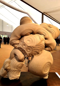
THE MOST FASCINATING exhibit I saw at the Frieze Masters art fair in London’s Regents Park, was unlike most of the other exhibits, not man-made. The item was about four feet high and slightly less wide. At first sight, it looks like a piece of modern sculpture, and one side of it resembles a vorticist version of the famous Michelin Man. But it is neither modern, nor made by human hands. It is between 300000 and 50000 years old, a fine example of a gogotte.
“… natural creations formed out of sands deposited in Northern France during the Oligocene Period, approximately 30 million years ago. Much later, in a process that has only recently become understood, groundwater rich in silica flowed through the sands, creating swirling organic shapes and cementing the sand into the fluid forms that we see today. This geological process took place during two cold periods of the Quaternary—one approximately 300,000 years ago, the other more recent, during the last glaciation, between 30 and 50,000 years ago.”
Apart from being interesting looking geological specimens, they have attracted the attention of artists. Some of them collected gogottes, and they and others have been influenced by their forms. These artists included: Henry Moore, Jean Arp, Constantin Brancusi, Barbara Hepworth, the Surrealists, and others. In addition, the curious gogottes have attracted the interest of collectors since as early as during the Song Dynasty (960–1279).
Gogottes are quite easily available. Their price depends on size. The specimen on display at Frieze is large. I asked one of the gallery assistants working on the stand where it was displayed for how much it was being sold. Sadly, she did not know.
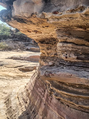
I HAVE VISITED the famous Grand Canyon in the USA, and seen it after a heavy snow fall. I have also seen a fabulous canyon in New York State, a few hours drive away from Buffalo. However, it was not until the first of February 2023, that I heard of, and then visited a grand canyon in Kutch, which is now part of the Indian State of Gujarat.
The canyon, named Kadiya (aka Kaliya) Dhro, is 73 Km north of the coastal city of Mandvi, and 33 Km northwest of Bhuj. Although the canyon is many, many thousands of years old and had been known to locals forever, its existence only became widely known in 2020. It was then that Varin Suchday, founder of the Kutch Travel Club stumbled across it. He had heard it discussed by local tribes people, whilst he was assisting them during the covid19 crisis, and with considerable difficulty, he managed to find it in the midst if the poorly mapped, arid semi-desert countryside.
We drove from Mandvi to a dusty parking area about 4 Km from the canyon. Several battered jeeps wait there to take visitors to the site. We boarded a well-worn Mahindra jeep, which was driven by a young fellow who looked to be about 15 years old; his voice had not yet broken. He drove us skilfully along sandy tracks strewn with rocks, precarious slopes, potholes, and other hazards. We held on to the Mahindra’s metal structural elements to avoid being thrown out of the constantly jolting and tilting vehicle, which had neither doors nor seatbelts. The tortuous track threads its way across dried up beds of streams; over boulders and sharp projecting stones; and past branching cacti and thorny bushes. Every now and then, other faster jeeps overtook us on this perilous, winding path. Other vehicles travelling in the opposite direction either waited for us to pass or vice-versa. After about thirty minutes of this exciting journey, we reached a parking area near the canyon.
The canyon is in the district of Ulat village, which we did not visit. A fast-flowing river, in which our driver spotted a crocodile, has over the millennia formed the canyon. Like the Grand Canyon, but far smaller, its walls are horizontally striated. The striations vary in colour. Here and there, you can see roundish rock formations that look like huge mushrooms. Their stalks are also striated. Parts of the riverbed that are not submerged are rocky platforms with patterns of grooves resembling crazy paving. The striations result from the alternate layers of shale and sandstone combined with the effects of sea air (for more detail, see: https://zeezest.com/travel/kaliya-dhrow-in-kutch-is-a-geological-wonder-to-behold-zee-zest-1054).
We visited the canyon on a Wednesday morning during the school term, so the place was not crowded. I have been told that on Weekends and during school holidays, large crowds of people come to view the interesting geological formations. We saw less than twenty other tourists, mostly Indian. Many were standing precariously on the rocks close to the water, posing for pictures probably destined to appear on Facebook and/or Instagram. I took many photographs of this lovely place.
I am extremely grateful that my wife’s cousin, who lives in Mandvi, arranged for us to visit the canyon, a geological jewel hidden deep in the Kutch desert. Although far off the ‘beaten track’, it is a highly worthwhile destination. A word of advice: the ride in the jeep is not a good idea for those with unhealthy backs!
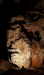
LONG, LONG AGO, the land where Torquay now stands was below the Equator in the southern hemisphere. Shifting of tectonic plates over the millennia has moved it to where it is now. Along with this migration, a series of caves has also reached this location but far beneath the town, about 1 mile northeast of the Torquay Harbour seafront. The cave network known collectively as Kents Cavern has been open to the public since 1952. What makes it fascinating is that archaeologists have found, amongst other things, the earliest known human remains in Britain. Three types of hominid have made, use of these caves: Homo heidelbergensis (thrived roughly 750,000 to 200,000 years ago), Homo neanderthalensis (thrived from 400.000 to 40,000 years ago), and Homo sapiens (that is us today: we have been around since about 300,000 years ago). The two earlier forms of hominid lived or sheltered in the caves. Now, we, the current edition of this type of primate, merely explore the caves as archaeologists, and visit them as tourists.
The earliest evidence of recent exploration of the caves is some inscriptions found within them. William Pete scratched his name on a stalagmite in 1571 and Robert Hedges did the same in 1688. Scientific exploration of the caves began in the early 19th century. In 1824, the geologist Thomas Northmore (1766-1851) made the first recorded excavation in 1824. Since then, others have made systematic archaeological excavations and discovered the remains of our early ancestors, their tools, and the remains of animals that sheltered in the caves. Two notable explorers of these underground passages and caverns are The Reverend John MacEnery (1796-1841) and William Pengelly (1812-1893). The latter established his reputation as an archaeologist by his discovery of the hominid remains in Kents Cavern. In addition, his discoveries helped in to prove that the biblical chronology of the earth was incorrect.
In 1903, the caves were acquired by a carpenter, Francis Powe, who used them as a workshop for constructing beach huts for the seafront in Torquay. His son, Leslie, converted them into a tourist attraction by installing electric lighting and laying down concrete paths. The caves are now run by a member of the family, Nick Powe.
At first sight, the visitor complex with its shop and café seems unexceptional and rather too ‘touristy’ for my liking. Visitors are escorted within the caves in groups led by a guide. The tourist facilities give little or no clue as to the wonders that await visitors after they step into the parts of the cave system that are on display. We were guided by a knowledgeable man, who was able to make geology and archaeology both palatable and extremely comprehensible to us. Even if you had had no interest in these subjects prior to going on the tour, he was able to sow seeds of interest in these subjects during the tour. Not only did he relate the facts clearly, but he was able to recreate in our minds the nature of life in the caves as it was when our ancestors illuminated them with lamps consisting of fat impregnated moss or other vegetable matter in scallop shells, and when enormous wild bears and other creatures hibernated or roamed about in these dark spaces. In addition, he pointed out interesting features of the geology of the caves including, stalagmites and stalactites in various stages of their continuing formation. Throughout the tour, our guide explained the difficulties that early explorers of the cave encountered.
To conclude, a visit to Kents Cavern is both visually spectacular and of great interest. Having seen the place, I would say that a visit to Devon must include a wander through these caves.
MUCH OF FOLKESTONE, a seaside town in Kent, is perched on slopes leading down to cliffs overlooking the shoreline. The Leas, a wide promenade running along the top of the cliffs to the west of the centre of the town, affords fine views of the beaches and rocks far beneath it. Various staircases, a lift (out of action nowadays), and paths lead from The Leas down to the seashore and the park that runs alongside it. The most fascinating of these, The Zigzag Path, begins close to a cast-iron bandstand a few yards west of the statue of the scientist/physician William Harvey. I loved it so much that I walked down it three times in the three days we spent in Folkestone recently.
With five hairpin bends and a couple of short tunnels as well as blind ending caves, The Zigzag Path takes pedestrians down from the Leas at 150 feet above sea level to lower than 42 feet above the sea. The path is like a winding mountain road in miniature and provides endlessly changing views of the seashore and the trees and other vegetation growing near it. In more detail:
The steep path was built for Folkestone Corporation in the early 1920s. The first attempt was not brilliant. So, the Corporation employed Mr Pulham of the company of James Pulham & Son, who specialised in the construction of rock gardens, follies, and grottoes (https://en.wikipedia.org/wiki/James_Pulham_and_Son). The company’s founder, James Pulham (1820-1898) was the inventor of a manmade (anthropic) rock-like material known as Pulhamite. This composite material simulates the appearance of natural rock so successfully that sometimes geologists are fooled by it. Pulhamite is a mixture of sand, Portland cement, and clinker, which is sculpted over a core consisting of rubble and crushed bricks (https://en.wikipedia.org/wiki/Pulhamite). The Zigzag Path was built with Pulhamite. While walking down the path, I spotted several places where the surface of the Pulhamite had worn away leaving fragments of brick exposed. If I had not seen this, I would have found it difficult to believe that the path was not created using natural rock. Recently, interesting ironwork railings have been added to the side of path facing the sea. These incorporate metal features that resemble plant tendrils wrapping around a support.
The wonderful Zigzag Path is just one of many of the Pulham’s ornamental creations. A full listing can be found in “Rock Landscapes: The Pulham Legacy: The Pulham Legacy: Rock Gardens, Grottoes, Ferneries, Follies, Fountains and Garden Ornaments” by Claude Hitching and Jenny Lilly. A visit to Folkestone would not be complete without experiencing the beautiful and rather fantastic Zigzag Path, preferably by descending it. If you decide to ascend it, you will have done sufficient exercise not to need to visit the gym that day.
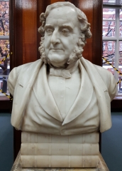
A WHITE STONE BUST depicting a man wearing a jacket and a waistcoat is perched on a pile of books carved in the same material and stands on a marble pedestal in the centre of the open access bookshelves in the public lending library on Hornton Street in London’s Kensington. His face has copious mutton-chop sideburns but neither moustache nor beard. The person depicted is James Heywood (1810-1897), who founded the first public library in Kensington in about 1870. His sculptural portrait in the library was created by Middlesex born James Adams-Acton (1830-1910), some of whose other busts include representations of Emperor Caesar Augustus, John Wesley, and ‘Pharaoh’s daughter’ (www.artuk.org/discover/artists/adams-acton-john-18301910).
Heywood, who was born in Manchester, was a man of many achievements (www.gracesguide.co.uk/James_Heywood). Son of the banker Nathaniel Heywood, James studied at the universities of both Edinburgh and Geneva before joining the family bank at Manchester. On inheriting a large sum from his uncle, he left the bank and matriculated at Trinity College Cambridge in 1829, where he continued to study but did not graduate. In 1838, he was admitted to the Inner Temple in London, where he was called to the Bar but did not practise as a barrister. In that same year, James became a founder member of the Manchester Geological Society. The next year, he was one of the founders of the Manchester Athenaeum, which provided reading rooms and lectures.
“James Heywood, Esq of Trinity College, Cambridge, residing at 17 Cork Street, London, Barrister of the Inner Temple, author of a Report on the Geology of the Coal District of South Lancashire, published in the Transactions of the British Association, & also of a Report on the state of the population in Miles Platting, Manchester, published in the Journal of the Statistical Society of London; a gentleman much attached to science, being desirous of becoming a Fellow of the Royal Society, we the undersigned, do, from our personal knowledge, recommend him as deserving of that honor, & as likely to be a useful & valuable member.”
So, by 1839, Heywood was residing in London. In addition to his scientific work, he was involved in politics. Between 1847 and 1857 he represented the constituency of Lancaster Northern. He was a member of the Whig/Liberal Party. In 1859, he moved to Kensington (Kensington Palace Gardens), where in about 1870 he established Kensington’s first free public library at Notting Hill Gate. Heywood was a Unitarian. His home in Kensington was close to the current location of a Unitarian church, which was only established on this site in 1887. However, before that, in 1867, the Unitarians began meeting in Kensington at Sir Isaac Newton’s old home, now demolished, in Church Lane. The history of the Kensington Unitarians, found at www.kensington-unitarians.org.uk/images/EssexChurchInKensington_forInternet.pdf reveals that:
“The congregation was growing under the Chairmanship of James Heywood, MA, FRS, MP, ‘one of Kensington’s most distinguished citizens’…”
The church moved to its present site near the Mall Tavern in the 1880s.
The free library, which Heywood created in Kensington and was opened on the 15th of August 1874, was located at ‘106, High Street, Notting Hill”, according to “The Catalogue of Mr James Heywood’s Free Public Library”, published in 1879 (and viewable on Google Books). The ‘High Street’ is now named ‘Notting Hill Gate’. If the numbering was the same then as it is today, then 106 would have been on the north side of the street just west of Pembridge Road, roughly between where Tescos and Mark and Spencers Simply Food stores stand currently. Today, the Notting Hill Gate branch of Kensington’s public libraries stands on the corner of Pembridge Road and Pembridge Square.
Heywood’s library was open seven days a week and before receiving a book, an applicant had to fill in a form with the following wording:
“I REQUEST TO READ
Name of books ….
Date …. Signature of applicant .…”
Reading books in the library was free of charge but borrowing them required a monthly payment of sixpence (2.5 p) and one penny (about 0.5 p) per book borrowed. The catalogue included a very respectable variety of books and periodicals. I was pleased to note that there was a book about Albania, “Travels in Albania and Other Provinces of Turkey” by Lord Broughton, Baron John Cam Hobhouse Broughton (1786-1869), who accompanied Lord Byron on his trip through the Balkans at the beginning of the 19th century.
Given his important contribution to the development of public libraries in Kensington, it is entirely appropriate that James Heywood is commemorated in the main branch of the library system of the Royal Borough of Kensington and Chelsea. It is also worth noting that like his pioneering establishment in Notting Hill High Street, the library is not entirely free for borrowers. Although books may be borrowed free of charge, other items including DVDs can only be borrowed after making a payment.
WE DROVE AWAY from the sun-soaked, windswept sands on the sea front in Paignton (Devon) and headed upwards on to Dartmoor. We followed narrow roads, often barely wide enough for a single car, bounded by hedges, until we rumbled across cattle grids and entered the wide-open spaces of the moor. The roads remained narrow, but the vistas were wide open. Patches of the moor have been cultivated but most of it is not. Sheep, cattle, and occasional horses or ponies grazed here and there.
We headed up a hill topped with what looked from afar like the ruins of a temple or a small fortress. As we neared it, we saw it consisted of piles of huge flat surfaced, irregularly shaped greyish boulders piled on top of each other in what seemed like a state of precarious balance. It appeared as if a giant had collected these stones and put them together in piles, as if to tidy up the land around them, to clear the space for animals to graze. We had arrived at Combestone Tor. A ‘tor’ is defined as:
“… a large, free-standing rock outcrop that rises abruptly from the surrounding smooth and gentle slopes of a rounded hill summit or ridge crest.”
The definition of tor includes the rocky outcrops I have seen in South Africa, where they are known as ‘koppie’ or ‘kopje’.
We walked from the car park towards the picturesque, tall piles of rocks, the tor, arranged almost artistically. Nature has done a better job aesthetically than many modern artists. A strong warm wind buffeted us as we approached them. It is weather conditions, like wind and rain, that have shaped the stones over the centuries and millennia. The formation of these geological formations began about 280 million years ago when molten rock crystallised to form granite (see: www.dartmoor.gov.uk/data/assets/pdf_file/0025/72097/lab-tors.pdf ). To cut a very long story short, rock covering the granite gradually wore away, allowing the granite to become exposed to the atmosphere. Oversimplifying a lot, the minerals between the lumps of granite became worn away by meteorological forces and, during the ice age(s), by mechanical forces generated by freezing and thawing. What has been left after all this is what we see today.
The earliest surviving written mention of Combestone Tor was in 1333, when it was named ‘Comerston’ (see: http://www.legendarydartmoor.co.uk/combe_stone.htm). On an 1809 map the tor is named ‘Cumstun’. Over the years its name has mutated to ‘Combestone’.
We wandered around the tor enjoying the amazingly balanced jumble of rocks of different sizes and the views of the surrounding landscape that stretches far below the summit of the hill (1168 feet above sea level) on which the weathered stones perch. Nearby brown cattle grazed, probably unaware of the strange geological formations, which we had come to enjoy. Recently, we visited the former home and gardens of the sculptor Henry Moore. His often huge sculptures dominate the landscape like the stone pillars that form the tor. Whereas Moore’s sculptures seemed to intrude on the landscape and deform one’s view of it, the rocky piles that comprise the tor feel harmoniously integrated into their surroundings. Give me moor, rather than Moore, any day!
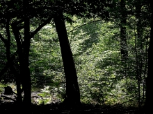
AN ANCIENT WOOD IS one that is at least 400 years old and has probably been in existence since time immemorial. Several of these ‘prehistoric’ woods have survived the spread of London over the centuries. Often, they are islands of wildness in a sea of suburbia, as is the case of Coldfall Wood near East Finchley and Muswell Hill in North London. We visited it on a damp afternoon when the trees were dripping with rainfall. This heightened the sense that we were strolling through a landscape little changed from the time when London had not extended so far into what was mostly untamed countryside.
Coldfall Wood was originally named ‘Colefall’, a word possibly derived from the Old English words ‘cole’ and ‘gefeall’, probably used to describe a place where charcoal was burnt. It is named that way in a document dated 1599 and on an Ordnance Survey map published as late as 1877. In 1599, there was a murder in the wood. This was not an uncommon event in Finchley, whose common land (which included Coldfall Wood) was the haunt of highwaymen and other miscreants for many centuries, and especially during the 18th. The wood made history in the world of geology in 1835 when (according to an article that can be found at http://www.locallocalhistory.co.uk/gd/gdpage04.htm):
“…At a spot in Coldfall Wood, just beneath the vegetable soil, an eminent London geologist, Mr. N. T Wetherell, of Highgate, discovered a strange accumulation of fossil remains, consisting of miscellaneous rocks, shells, teeth of fish, and bones of saurians of extinct species, evidently brought hither by some unknown agency from the formations of various northern areas of England.”
The importance of this discovery led to the suggestion that:
“… the southern lowlands of England, as well as the mountains of Wales and the northern counties, showed traces of their former occupation by glaciers, and perhaps a glacial sea.”
However, this idea mooted in the 19th century has been challenged. It is now thought unlikely that Muswell Hill was once submerged beneath a glacial sea (although the glaciers did reach the area).
The present Coldfall Wood, which is a reduced version of what it was before the mid-19th century, is a deformed square in plan, its southern border, which is bounded by Creighton Avenue, being longer than its northern one. In the past, the wood extended southwards and reached the road now called ‘Fortis Green’ that existed from the early 19th century. Incidentally, the settlement of Fortis Green was in existence by the 16th century. The wood slopes downhill from its southern and western edges. At its southwest corner, it is just over 300 feet above sea level and at its north eastern corner, it is at least 60 feet lower.
Distinct footpaths both circumnavigate and traverse the wood. Because of the density of the trees, the buildings surrounding the wood are mostly hidden and the 14-hectare (35 acre) woodland feels much larger than it is. Every now and then, the footpaths cross small footbridges. These structures traverse often barely perceptible beds of streams, many of which were waterless on the August afternoon of our visit. In the lower reaches of the wood, the streams were filled with water. At the lowest corner of the wood, there is a wetland area traversed by an elevated wooden walkway. The water that flows down the slopes of Coldfall Wood disappears underground at the lowest (north east) corner of the woodland.
East Finchley, in which Coldfall Wood is located, is a watershed for two of London’s rivers, both tributaries of the Thames. From the western slopes of East Finchley, water runs into the River Brent whose mouth is at Brentford in West London. Water from the eastern slopes heads eastwards towards the River Lea whose waters flow into the Thames in London’s East End. I believe that this is the case for the water from the streams in Coldfall Wood.
I believe that I might have visited Coldfall Woods once before while visiting a dear friend, sometime in the late 1970s. Neither then nor a few days ago, when I made my second visit there, did I have even the slightest inkling of its history and geological significance. As we still have good friends who live close to it, it is likely that my next visit to Coldfall Wood will be in much less than forty years’ time.