MOSES AND HIS followers crossed the Red Sea without difficulty. However, things were not so simple when a group of people were trying to cross the Atlantic to enjoy freedom to worship as they wished without persecution in North America in 1620 during the reign of England’s King James I. These travellers. the Pilgrim Fathers, were English Protestants, Puritans who had been living in the Low Countries in Leiden but felt that conditions there had become unfavourable for them. As they did not expect to live safely in England, they bravely set forth to sail to the New World.
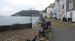
Bayards Cove
The Pilgrim Fathers and their families left Holland in the “Speedwell” (60 tons) and after crossing the North Sea, their ship was joined by the larger “Mayflower” (180 tons), which was carrying Puritans fleeing from London. While heading west, the boats headed into trouble. On about the 23rd of August 1620, the two ships slipped furtively into Dartmouth in Devon and lay at anchor near to the town’s Bayards Cove, close to where today a small ferry carries vehicles and pedestrians across the River Dart between Dartmouth and Kingswear. The secrecy was necessary because as Puritans, the passengers risked punishment in England. They remained moored there until about the 31st of August while leaks on the “Speedwell” were being repaired.
After leaving Dartmouth to continue their voyage westwards, the “Speedwell” began leaking again. About 300 miles west-south-west of Lands’ End, the “Speedwell” had become almost unseaworthy. The boats returned to England, docking at Plymouth in Devon. There, the “Speedwell” was abandoned, and the “Mayflower” set sail for America with 102 passengers. The boat reached the harbour of Cape Cod in Massachusetts on the 21st of November 1620.
Although Plymouth is the place from which the Puritans finally left England, the point in the port from which they set off would now be unrecognisable to the Pilgrim Fathers were they able to see it. In contrast, although some of the buildings near Bayards Cove in Dartmouth have been built since the Pilgrim Fathers stopped there briefly, there remain sights that have not changed significantly since 1620.
FOR PERSONAL REASONS King Henry VIII dissolved all the monasteries and similar establishments in England during the 16th century. Many of their buildings were destroyed or left to disintegrate. Their lands were sold or given to new owners. Some of them incorporated the remains of the monastic structures that they had acquired into new buildings. A good example of this can be seen in Devon’s Torquay. It is the remains of Torre Abbey.
The abbey was founded by members of the Premonstratensian Order in 1196. By the time of the Dissolution in 1536, Torre Abbey was the wealthiest of the houses of the Order in Britain. In 1539, the monastery was given over to one of King Henry VIII’s commissioners. After that, the first leaseholder of the former abbey and its lands was the lawyer Sir Hugh Pollard (?1498-?1576). What was left of the monastic buildings was incorporated into a large house built for Thomas Ridgeway. After several others had owned the property, it came into the hands of the Cary family in 1662. In 1740, the residential building was remodelled in the Georgian style, which is what can be seen today. This family retained ownership of the abbey remains, the house, and its lands, until 1930, when a member of the family sold them to Torquay Borough Council. Since then, the house has been used for municipal administrative purposes and during WW2, it was occupied by the RAF.
Near to the main house, there is a large, intact tithe barn. This was constructed in about 1300. In the summer of 1588, the Spanish sent a large fleet, the Armada, to invade England with the intention of restoring the Roman Catholic religion in what had become a Protestant country. The Spanish failed miserably, and many of them became prisoners of war. Francis Drake (c1540-1596) forced one of the Spanish vessels to surrender and as a result captured 397 Spanish prisoners. They were held in the tithe barn for 23 days before they were transferred to Exeter. As a result of this, the barn is now known as The Spanish Barn. during WW2, the RAF used it as a gymnasium. Now, the barn is hired out for weddings and other special occasions.
The remains of the abbey, the barn, and the house built within the abbey ruins, overlook a park, a small golf course, and a few yards away, the waves in Tor Bay. The abbey grounds are a short walk from the commercialised harbour area in the centre of Torquay, and provide a pleasant contrast to the latter.
ISAAC BASHEVIS SINGER, the author, should not be confused with Isaac Merritt Singer (1811-1875), the American born inventor of a successful version of the sewing machine. By 1862, he had fathered 18 children with several different women. In 1862, Isaac and his second wife, Isabella Eugénie (née Boyer), shifted from the USA to Europe because of his scandalous reputation in the States. They lived in Paris until the outbreak of the Franco-Prussian War in 1870. Then, they moved to England with their six children. For reasons connected with its mild climate, the family moved to the Torbay area in early 1872. By then, he had already purchased the Fernham Estate in Paignton, next to Torquay.
Oldway Mansion, (Paignton) Torquay
Singer and his family squeezed into Little Oldway, a villa on the estate, which had been built in about 1850. Next, he commissioned the architect George Soudon Bridgman (1839-1925) to help him design his ‘dream house’, the basis for the present grandiose Oldway Mansion, and the neighbouring circular building, the Rotunda. The latter was designed for stabling and as an exercise pavilion. The house was completed by the end of 1875.
What we see today is not what Isaac would have seen when the edifice was completed. Between 1904 and 1907, Paris Singer (1867-1932), one of Isaac and Isabella’s sons, who had bought the mansion from the Singer Trustees in 1893, made major changes to its appearance. He engaged two French men, the garden designer Achille Duchêne (1866 — 1947) and his father Henri, to design his new home, the present Oldway Mansion. His aim was to create an edifice inspired by the Palace of Versailles. The reconstructed (remodelled) mansion is a magnificent imitation of a French palace in the style of that which can be seen at Versailles. It incorporates decorative features copied from notable buildings in France. Its interior, which I was unable to see, is grandiose and includes fine paintings and a reproduction of the Hall of Mirrors.
In 1917, after having had an affair with the dancer Isadora Duncan (1877-1927) in 1917, Paris moved to the USA for tax reasons. After having been used for various purposes, Paignton Urban District Council bought the property from the Singer family. Currently, the building is mostly disused apart from a small, but pleasant café. Its formal gardens are well-maintained, but the mansion and the Rotunda are in need of maintenance. Oldway Mansion looks rather like an abandoned Russian aristocrat’s palace many years after the Revolution.
THERE IS A LOVELY STRETCH of the railway from London Paddington to Devon and Cornwall. It is between Exeter and Newton Abbot. The train runs from Exeter along the western shore of the wide estuary of the River Exe, then along the seashore between Dawlish Warren and Teignmouth (often between the base of cliffs and the sea), and finally turns inland to run along the shore of the broad River Teign to reach Newton Abbot. This scenic stretch of track helps make the trip to the far southwest extremely pleasant.
In August 2020, our friends in Torquay took us by car to Teignmouth and other points along this scenic rail route. It was fun to stand near the track and watch trains rushing past. One of the places we visited on that trip was the small village of Starcross, where a small passenger ferry crosses the Exe, carrying pedestrians, cyclists, the crew and their small dog to and from Exmouth. Near the Ferry embarkation point which is reached by crossing the railway via a footbridge, I spotted something quite surprising for this day and age of concerns about health and safety. A small gate (‘kissing gate’ variety) for pedestrians allows people to cross the tracks to reach the beach beyond them. This crossing is unguarded and permits folk to walk across two lines of track along which trains hurtle every few minutes. A sign exhorts those foolhardy enough to make use of this crossing to “Stop, Look, and Listen”.
Near the pier where one boards the ferry at Starcross, there is a brick building with white stone facings and a tall square brick tower. This edifice that has an industrial appearance stands close to the railway lines. In days gone by, it was a pumping station for a railway whose trains were propelled by compressed air, the so-called ‘Atmospheric Railway’.
The South Devon Atmospheric Railway, which followed the route taken by trains today, ran between Exeter and Plymouth. The construction of the westbound line from Exeter, The South Devon Railway, gained Parliamentary authorisation in mid-1844. Isambard Kingdom Brunel (1806-1859) was the engineer in charge of constructing the South Devon Railway. Given the then current power of steam locomotives, he decided that they would not have sufficient strength to deal with some of the gradients along the route. He opted to use propulsion generated by gases under pressure – the atmospheric system. One of the pioneers of atmospheric railways was the English engineer and politician Joseph d’Aguilar Samuda (1813 –1885), whose ideas influenced Brunel.
Trying to put it as simply as possible, here is how I understand that the atmospheric railway system worked. A cylindrical metal traction pipe was laid between the railway tracks. This pipe had a longitudinal slit facing upwards. The slit was sealed shut by leather flaps that kept the pipe airtight when it was filled with compressed air provided by a series of pumping stations along the line. The building we saw at Starcross was one of these units, whose engines could generate between 45 and 82 horsepower.
The pumps injected air into the slitted longitudinal iron pipes (20 inches in diameter), whose leather flaps prevented escape of the gas. The trains using the atmospheric system were pulled by specially designed traction cars. Each of these cars was attached to a piston that fitted snugly within the air pipes running along the track. The attachment of the piston to the traction car was fitted with a mechanism that opened the short section leather flap immediately beneath it. The compressed air exerted pressure on the end of the piston, causing it to move along the pipe. Being attached to the traction car, the motion of the piston caused the car to move along the tracks. As the traction car was attached to the carriages, they were pulled along by the air-propelled traction car. As soon as the traction car moved along the track, the part of the flap that had been open momentarily, then closed, and the next short section opened briefly. What I have described is an oversimplification that ignores how the system dealt with points, level crossings, etc. More detail is available for those interested on various websites (e.g. https://railwaywondersoftheworld.com/atmospheric-railway.html and on Wikipedia).
This system of propulsion was able to propel trains at speeds up to 70 miles per hour, although this speed was rarely attained. It also allowed trains in the late 1840s to overcome gradients that would have been too challenging for the steam engines at that time. The system was abandoned in about 1848. The leather valves caused numerous problems. Air leakage was one of these. Throughout the year, the leather dried out and became too stiff for use. In winter, frost also damaged their flexibility. Throughout the year, they provided food for rats, whose activities were detrimental to their efficient functioning. The rat story is oft quoted but WG Hoskins, author of the much-respected book “Devon” notes that the atmospheric railway:
“… was a complete failure mainly because of the decomposing action of water and iron on the vital leather component of the valves … In September 1848 the line was worked by locomotives and the ‘Atmospheric Caper’ was abandoned for good, after more than £400,000 of the company’s money had been wasted. Brunel had made a tremendous mistake …”
I wonder whether with today’s synthetic rubber the experiment could be repeated, thus creating a railway system that makes little use of diesel engines. I suppose that electrification of the line might be a more practical solution.
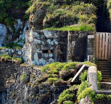
Today, the largest relics of the short-lived Atmospheric Railway are the well-built pumping stations such as the one next to Starcross Station and the ferry embarkation point. It was built in 1845 and designed by Brunel. It consists of two blocks and the tall, solid looking chimney (https://historicengland.org.uk/listing/the-list/list-entry/1097684). In 1869, the east block, which used to house the boilers, was converted for use as a Wesleyan chapel, and served this purpose until 1950. The west block used to house the beam engine that used to compress air. This block was later converted to an engine shed for housing steam locomotives until 1981, when it became home to a museum related to the Atmospheric Railway. In its heyday, the Atmospheric Railway was powered by 11 pumping stations, of which only four remain standing (Starcross, Totnes, Dawlish [not much left to see], and Torquay). There is one other souvenir of the ill-fated system at Starcross. This is a pub opposite the station. It is called ‘The Atmospheric Railway Inn’. Sadly, the covid19 pandemic has resulted in it deciding to remain closed for the foreseeable future.
I had never heard of the Atmospheric Railway until we visited our friends in Torquay. Had it not been for their suggestion that we took a trip across the River Exe on the ferry, I might never have noticed the former pumping station at Starcross and remained in ignorance of Brunel’s adventurous experiment in railway technology.
POSTBRIDGE IS A TINY SETTLEMENT in the middle of Dartmoor on the banks of the East Dart River, a tributary of the River Dart. The road that passes through the hamlet crosses the river over a venerable stone bridge (built in the 1720s). A few yards away from the bridge, there stands a far older bridge, a so-called ‘clapper bridge’.
The clapper bridge consists of four stone abutments (piers) spanned by three wide slabs of granite, each weighing about 6.5 to 8 tons. It is a simple but elegant structure, which has survived for many centuries. The bridge was most probably built to allow pack horses carrying tin to cross the stream on the way to Tavistock on the west side of Dartmoor. It was already in existence in the 13th century and is one of only 40 surviving examples of this kind of river crossing in the British Isles.
When we arrived at Postbridge during our journey from Cornwall to Somerset, the clapper bridge was crowded with camera-laden tourists who spoke German. Some of them were impolite, shouting at us rudely to get us to move off the clapper bridge so that they could get better photographs. Despite their uncultured behaviour, it was good to see that the bridge is still being used, albeit for leisure purposes. However, this is a far cry from what is depicted on a nearby pub sign: a horseman dressed in a red jacket riding his horse over the ancient bridge,
MY FASCINATION WITH MILITARY bunkers began after visiting Albania in 1984, when the country was stilled being ruled by the last regime in Europe that still revered Joseph Stalin. Tiny Albania was surrounded by potential enemies, Greece, Yugoslavia, and Italy across the Adriatic. Having had his country invaded many times in the past, Albania’s dictator, Enver Hoxha (who ruled between 1945 and 1985) was determined to make the country as impregnable as possible. One approach that he adopted was to cover (literally) the entire country (towns and villages included) with small (and large) concrete bunkers, many of them were hemispherical in shape. As Albania was never invaded after 1945, the effectiveness of these concrete structures that looked like a severe rash of pimples was never put to the test.
Bunker at Torcross
The same can be said of the numerous concrete bunkers that were constructed in many strategic places all over England before and during WW2. Fortunately, the Germans never managed to invade the UK, with the exception of the Channel Islands. Judging by how useless the Maginot Line proved to be in France, I suspect that the British bunkers would have been fairly useless had the Germans invaded.
Today, we visited the tiny hamlet of Torcross in south Devon. It lies at the southern end of the long causeway that separates the sea from Slapton Ley, a large freshwater lake. While sitting at an outdoor table on the sea front at Torcross, I was staring at a picturesque rocky outcrop when I noticed what I thought was a rock with a rectangular slit cut in it.
Looking more closely using my camera’s zoom lens, I realised that the slit was really there, but it was cut in something that was not rock, but a thick concrete wall. The wall looked identical in texture to the rocks surrounding it. I realised that what I was looking at is an old bunker that ovelooks the long stretch of Slapton Sands, which is on the sea side of the causeway. It overlooks what would have been a perfect beach for a foreign invasion force to land.
In fact, the stretch of beach known as Slapton Sands was used by an invasion force in 1944. It was not a hostile force belonging to the Axis powers, but a friendly one used by Allied troops. The troops, mostly Americans, were using Slapton Sands to practice or rehearse the planned landings (on D Day) that were about to take place in Normandy as a prelude to recovering Western Europe from German occupation.
As I have described in another post, the rehearsing Allied troops were attacked by German boats, resulting in the tragic deaths of over 700 young Americans. The Germans, based in France, attacked the beach at Slapton Sands because they had picked up very busy radio signal activity in the area. Luckily for the planned invasion of France, the German attackers had no idea of what was being rehearsed at Slapton. Had they known they might well have returned to do even more damage that might have sabotaged the D Day invasion plans.
An amphibious tank, recovered from the sea in 1974, stands at Torcross as a memorial to the men who lost their lives during the German attack of the boats and other military positions at Slapton Sands.
Hence, it blends with its surroundings far better than it would have had it been built in concrete. Whether or not this and the other bunkers nearby were of any use when the Germans attacked during the very early hours of the 28th April 1944, I cannot say. However, I feel that given the devastating results of the German attack, this is unlikely.
Today, Torcross is a popular place with visitors. It has several eateries and places to stay. During past visits to this delightful spot, once the scene of a horrible tragedy, we have eaten good seafood at the Start Bay Inn, which is only a few feet away from the tank memorial. The inn was established in the 14th century, when it was known as ‘The Fisherman’s Arms’.
Visiting Torcross provides a good place to reflect on the heroism of those who fought in WW2. Little did those 700 or more men lost in this place in 1944 know that their sacrifice has allowed us to enjoy holidays at this beautiful spot. Whenever I am at Torcross, I have mixed emotions: joy because of the place’s great natural beauty, and sadness when I look at the tank memorial and remember why it is there. Had the D Day landings been thwarted, who knows under what kind of regime we would be living today.
WHEN YOU LEAVE THE A38 road near Buckfastleigh and head southwards, you enter the Devonshire district of South Hams. This picturesque part of southwest England contains three towns that attract many visitors: Dartmouth, Kingsbridge, and Salcombe. Each is located on hilly terrain and has its own distinctive charms. All of them have steep streets that lead to places with great views.
Dartmouth, the home of an important large naval college, occupies a position on the estuary of the River Dart. Although it attracts many holidaymakers, it has the feel of a working town. The river is filled with boats, some used by pleasure seekers, and others (including ferry boats and fishing vessels) are working craft.
Salcombe, like Dartmouth, perches on the slopes of the shore of an inlet of the sea. Of the three places mentioned in this essay, it has to win first prize for its setting and attractiveness. I have visited Salcombe both in August (high season) and in May (before the season began). During the high season, the small town is flooded with holidaymakers, day-trippers and those staying in the place (including many owners of second homes). The streets are almost clogged with people. In contrast, when we visited it in May, the tiny town was delightful and relaxing.
We have just returned from staying in Kingsbridge, which is a few miles up the same inlet as Salcombe. This is, at first sight, the least obviously alluring of the three towns. Hence, it attracts fewer visitors than Dartmouth and Salcombe. However, as you wander around the small streets in the historic centre of the town, its charms reveal themselves to the viewer. The town is rich in buildings from the 18th and early 19th centuries. The Quay, where the tidal inlet meets the town is beautifully landscaped. Visitors tend to congregate here to enjoy paddle-boarding, boating (when the tide is high enough), crab fishing, eating ice cream,and just passing the time of day. Also, the town has several excellent restaurants. Of these, I would single out: The Old Bakery (for well-prepared Mediterranean and Middle-Eastern style food), the Dodbrook Arms (with first-class cod and chips as well as other perfectly prepared dishes), and Woodys, which serves very good locally reared beef. Like Dartmouth, but unlike Salcombe, Kingsbridge gives the feeling of being more than a holiday destination; it is a real working town.
In between the three towns, there are many villages and beaches worthy of exploration. Of the three places, Kingsbridge has become my favourite and we hope to return to it soon to use it as a base to get to better acquainted with South Hams.
KINGSBRIDGE IS A SMALL town in South Devon. It lies at the head of an inlet of a ria (a completely submerged river valley) upon which the better-known and more popular resort of Salcombe is also located.
Many histories of Kingsbridge relate that the town resulted from the union of two neighbouring settlements, the neighbouring royal estates of Alvington and Chillington. Kingsbridge was formed around a bridge (possibly, a draw-bridge) that connected the two at the head of the inlet of the ria. The bridge was built by the 10th century. So far, so good, but today there is no bridge in the town of Kingsbridge.
If you drive from Kingsbridge towards Dartmouth via the A379 road, you will soon arrive at the New Bridge west of the town. This not so new bridge with five arches was built in 1845 and restored several times since then. It crosses Bowcombe Creek, another branch of the ria. This bridge is not, and has never, ben inside the town of Kingsbridge; it is well outside it. It is not, as has been suggested to me by several locals, the bridge that gave the town its name. So, where was the bridge?
By chance, I found a book about the history of Kingsbridge on-line. It is “Kingsbridge and its Surroundings” by SP Fox, published in 1874. This is the only source that I have found so far that mentions the site of the bridge in Kingsbridge. On page 10, the author noted:
“Nearly at the lower end, Fore Street is crossed at angles by Mill Street and Duc’c [now called Duke] Street, the former on the west side, leading to West Alvington and Salcombe; the latter on the east, in the direction of Totnes and Dartmouth, and uniting the towns of Kingsbridge and Dodbrooke by a very small bridge.”
The old bridge mentioned by Fox no longer exists, but the two streets mentioned do. Duke Street, which used to run through from Fore Street to Church Street near to the present Duke of Prussia pub (according to a late 19th century map), is now a cul-de-sac on which you can now find the main entrance to a popular fish and chips shop called ‘The Cod Father’. Mill Street is still a road leading towards West Alvington and Salcombe.
Where Fox describes the bridge, there is no sign of a ditch or stream today. Maybe, long ago there might have been a ditch or stream across which the bridge straddled. At the head of the inlet of the ria in Kingsbridge, there is a small arch, which might be the outlet to a formerly visible stream, which has long since been covered.
“The exact site and function of the bridge is of great interest, as clear documentary evidence for an Anglo-Saxon bridge in Devon is rare (Henderson and Jervoise 1938, 29; Hoskins 1954, 147), and, in the present context, because the development and character of the town, like its name, can be expected to have been fundamentally linked with that of the bridge and its highway. The attraction and shaping of urban growth to main roads and river crossings is a strong pattern across medieval Devon (Slater 1999). The detailed map analysis for the urban survey indicates that the early bridge may have crossed the River – between routes later altered to become Love or Boon’s Lane on the west side, and Quay Street on the east – downstream from a tidal ford on the Mill Street-Duke Street route and below the extent of the medieval town…”
So, we cannot be certain of the location of the old bridge.
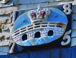
The coat of arms of Kingsbridge consists of a three-arched bridge surmounted by a royal crown. Whether or not the bridge had three arches is not at all certain, but the fact that it linked two royal estates justifies the presence of the crown. If the bridge was located where Fox believed, there was hardly enough width for a bridge with three arches.
But who was the king? It might well have been King Edgar, ‘The Peaceful’, who reigned from 959 to 975 AD. For, it was during his reign that a charter relating to boundaries dated 962 AD mentions the existence of a ‘king’s bridge’. That could also mean that the bridge was in existence before that king’s reign.
So, regardless of the actual position of the bridge after which Kingsbridge is named, we can be certain that the name is justified as there was a bridge somewhere in or near the town and it had royal connections. Whatever the origin of the name, the town of Kingsbridge is well worth a visit.
The River Dart viewed from the garden of Greenway House, which used to be the holiday retreat of author Agatha Christie from 1936 until her death in 1976.