Plants, electricity, and Mill Hill

AN AGED BRICK WALL, clearly once the boundary of the grounds of a grand house, runs along part of The Ridgeway in London’s Mill Hill. It bears a plaque commemorating the fact that this was once the site of Ridgeway House, the home of Peter Collinson (1694-1768), author, naturalist, and botanist. This was not a name with which I was familiar, yet he played an important part in the scientific life of 18th century London and further afield.

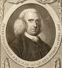
Peter Collinson, born a Quaker, the son of the owner of a textile business, was unable to attend university in Britain because in his time members of that branch of Christianity were not admitted. He inherited his father’s business and taught himself to such an extent and to such a high level that in 1728 he became a member of the prestigious Royal Society (www.londongardenstrust.org/features/millhill.htm provides a good biography of Collinson). His greatest interest was plants and gardening, and he was responsible for importing many plants such as magnolias, kalmias, rhododendrons, azaleas and cedars of Lebanon, which were then relatively new to the UK, into the country. He imported these plants in great quantities so that these could be planted all over the country and thereby enriched and transformed the landscape. His legacy may be seen in many of the landscaped gardens of the country’s great houses.

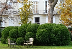
When Collinson’s father-in-law died in 1748, he inherited Ridgeway House in Mill Hill, which was built in about 1525, and moved there from Peckham. Apparently:

“The house had no particular architectural merit; it was described as “double-fronted” with French windows” that open onto the garden.”

Not only did he move his family from Peckham but also all the plants he had been growing there. At Mill Hill he created a wonderful garden, about which he wrote:

“Very few gardens if any excel mine at Mill Hill for the rare exotics which are my delight.”

(Both quotes from www.mhps.org.uk/collinson/botanical-contribution.asp#millhill).

Collinson became a good friend to a frequent visitor to England, the American Benjamin Franklin (1705/6-1790), who became a vegetarian in his teens, but is better-known for other achievements. Many of these were in the field of scientific research. The two men corresponded regularly (https://founders.archives.gov/search/Correspondent%3A%22Collinson%2C%20Peter%22%20Correspondent%3A%22Franklin%2C%20Benjamin%22). Much of the contents of their letters that sailed across the Atlantic concerned the exciting discoveries that Franklin was making in fields such as electricity. In the letter dated 28th of March 1747, Franklin thanked Collinson for his:

“… kind present of an electric tube, with directions for using it, has put several of us on making electrical experiments, in which we have observed some particular phaenomena that we look upon to be new. I shall, therefore communicate them to you in my next, though possibly they may not be new to you, as among the numbers daily employed in those experiments on your side the water, ’tis probable some one or other has hit on the same observations.”

Other matters were also discussed. For example, in a letter dated 9th of May 1753, Franklin wrote to Collinson:

“I have often observed with wonder, that Temper of the poor English Manufacturers and day Labourers which you mention,  and acknowledge it to be pretty general. When any of them happen to come here, where Labour is much better paid than in England, their Industry seems to diminish in equal proportion. But it is not so with the German Labourers; They retain the habitual Industry and Frugality they bring with them, and now receiving higher Wages an accumulation arises that makes them all rich.”

Much of Collinson’s correspondence with Franklin was to keep the latter up to date with scientific developments in Europe, especially those relating to new German experimentation with electricity. And much of Franklin’s correspondence with Collinson reported the results of his experiments with electricity in America, which Collinson conveyed to The Royal Society. It was these letters that were the basis of a book published by the Royal society in 1751, “Experiments and Observations on Electricity”, which is one of the most important scientific publications to emerge from 18th century America.

I cannot discover for sure whether Franklin ever visited Collinson in Mill Hill. However, Collinson did host the Swedish naturalist Daniel Solander (1733-1782), assistant to the great Swedish botanist Carl Linnaeus (1707-1778), at Ridgeway House. Linnaeus had earlier visited Collinson in Peckham. The Victorian guidebook writer James Thorne suggests that Linnaeus himself  also visited Collinson at Ridgeway House.

Solander travelled to England in 1760 to promote the system of classification of biological organisms devised by Linnaeus. In 1753, Linnaeus named a genus of flowering plants, ‘Collinsonia’, to honour Collinson. It was Collinson, who got Solander the job of classifying the natural history specimens in Sir Hans Sloane’s collection, which formed the basis of the recently established (1753) British Museum, which opened to the public in 1759. It was the combined efforts of Collinson and Solander that persuaded the British to accept the Linnean system of classification. In 1768, Solander was one of the participants on Captain Cook’s first voyage to the Pacific Ocean, and thus became the first Swede to circumnavigate the Earth.

Collinson died in 1768. From 1801, his property at mill Hill was owned by the botanist Richard Anthony Salisbury (1761-1829), a founder member and the founder Secretary of the Royal Horticultural Society. In 1807, he sold it to the group who founded the Protestant Dissenters Grammar School. the forerunner of Mill Hill School. Apart from six trees in the school’s grounds, much of Collinson’s collection of plants has disappeared. Ridgeway House, which housed the school at first, was demolished in 1826 when the present grand school buildings were constructed. Collinson would have been pleased to know that Mill Hill School was:

“… first educational establishment to provide a first class education for the sons of dissenters, those whose religious or philosophical outlook did not conform to that of the state and who, like Collinson, a Quaker, were barred from the attending the established seats of learning.” (www.mhps.org.uk/collinson/botanical-contribution.asp#millhill).

When I saw the old wall running beside the Ridgeway in Mill Hill and what was written on the plaque affixed to it, little did I realise that such an important man in the scientific community of the 18th century had lived on the other side of it.

Appeasement and leisure in a London park

NEVILLE CHAMBERLAIN (1869-1940) has earned a poor reputation, mainly because of his unfortunate policy of appeasement with Nazi Germany in the late 1930s, which included the Munich Agreement in September 1938, which allowed the Nazis to invade the Sudetenland, the western part of Czechoslovakia. It took the disastrous German invasion of Poland before the then Prime Minister, Chamberlain, finally made Britain declare war on Germany.

Today (24th of November 2020), we revisited Gunnersbury Park, which we ‘discovered’ for the first time a few weeks earlier. The front of the grand house, the Large Mansion, which was acquired by Nathan, a member of the Rothschild family, in 1835, has a terrace running next to its long rear façade. At each end of the terrace, there are two neo-classical archways, which we did not examine carefully on our first visit.

In one of these arches, there are two commemorative tablets inscribed in upper-case lettering. Both note the fact that Gunnersbury Park was opened for use by the public by “The Right Hon. Neville Chamberlain, M.P., Minister of Health”. The rest of the information on the tablets relates to the financing of the purchase of the park (from Lionel Nathan de Rothschild). One tablet commemorates that a quarter of the cost of the park, purchased by the Boroughs of both Acton and Ealing, was provided by Middlesex County Council. The other tablet recalls that in 1927, The Urban District Council of Brentford and Chiswick joined those of Acton and Ealing in the ownership and running of the public park. Thus, for a while, the park was managed by three different district councils. In 1965, Brentford and Chiswick became absorbed into the new Borough of Hounslow. That year, the Borough of Acton became part of the new enlarged Borough of Ealing. So, now the park is managed by two boroughs instead of three. According to a gardener, with whom we spoke, one of these boroughs has spent far more money on the park than the other.

In 1926, when he opened the park at an occasion that has been recorded on film (https://player.bfi.org.uk/free/film/watch-the-official-opening-of-gunnersbury-park-by-the-rt-hon-neville-chamberlain-m-p-1926), Neville Chamberlain was Member of Parliament for Birmingham Ladywood, representing the Unionist party, now part of the Conservative and Unionist party. Two years before he opened Gunnersbury Park, he was appointed Minister of Health by the then Prime Minister Stanley Baldwin.

Although he might have had good reasons for doing so, allowing the Germans to enter Czechoslovakia and overrun the Sudetenland seems unforgivable. However, and this by no means makes his policy of Appeasement more palatable, his opening the gates of Gunnersbury Park to the public has provided joy to visitors from near and far for many decades. I heartily recommend a visit to this lovely place filled with picturesque delights.

Oliver Cromwell in Essex

YOU CAN NO LONGER ENJOY a tankard of ale at the Sun Inn in the Essex town of Saffron Walden. However, you can still enjoy the fine pargetting (moulded sculptured plasterwork) that adorns it.

The building that housed the former Sun Inn was built in the 15th century. Late in the 16th or early in the 17th century, an upper floor was added. Indeed, one of the gables with fine pargetting bears the date 1676. This might have been the date when the present pargetting was created or when the upper floor was added, or even both. The former inn has an opening that allowed wagons and other traffic to enter the yard behind it.

The pargetting is described well in a website (www.british-history.ac.uk/rchme/essex/vol1/pp228-260) as follows:
“… in the middle bay are two late 17th-century panels in plaster, one with a design of foliage and birds, and the other with a stocking; in the S.W. gable is a design of the same date in plaster, which consists of a circular panel divided into twelve segments; on each side is the figure of a man in a long coat, knee-breeches and high-heeled shoes; one figure holds a sword and buckler, the other a long club.”

One of the panels, that with the man with a sword and the other with a long club, respectively represent Thomas Hickathrift and the Wisbech giant (https://heritagerecords.nationaltrust.org.uk/HBSMR/MonRecord.aspx?uid=MNA108635). Thomas (‘Tom’) Hickathrift was a mythical East Anglian giant-killer, a giant of a man, whose exploits included slaying the Wisbech Giant.

Today (late 2020), the group of beautifully decorated houses that includes the former Sun Inn is empty. The ground floor of part of the building bears a shop sign ‘Lankester Antiques & Books’. Run by Paul Lankester of Thaxted in Essex, the shop closed after 48 years of business in July 2015. Another sign near it reads ‘The 14th century Old Sun Inn. Oliver Cromwell’s Headquarters 1647’. In 1647, when Cromwell’s New Model Army had won the first civil war for the Parliamentarians, they gathered in Saffron Walden. For various reasons the war weary army was becoming dissatisfied. Cromwell and his officers arrived in Saffron Walden on the 2nd of May 1647 to try to satisfy the troops’ various demands and to deal with their grievances (www.saffronwaldenreporter.co.uk/news/a-lasting-place-in-history-1-377880). He was unable to do so and returned to London after staying in the town for 19 days. 

Although the town has many other attractions, seeing this old building with its exquisite external decorations is on its own an excellent reason to pay a visit to Saffron Walden.

Kit Kat in Hampstead

KIT KAT CONFECTIONERY BARS are familiar to many people and I enjoy eating them occasionally. The ‘Kit Kat’ and ‘Kit Cat’ tradenames were registered by the Rowntree’s confectionery company in 1911, but the first chocolates bearing this name only appeared in 1920. Had you wanted to eat a Kit Kat in the early 18th century London, you would not have been served a chocolate item but a type of mutton pie. The Kit Kat mutton pie was the creation of Christopher Catling (aka ‘Katt’ and ‘Cat’), who had a pie house in Shire Lane near Temple Bar, which used to stand near the present-day Royal Courts of Justice on London’s Strand.

When walking in Hampstead Village recently, we saw something I had never noticed before during at least 60 years of visiting the area. It was wording above the doorway of a house on the corner of Heath Street and the much narrower Holly Bush Steps. The words are: “Kit Cat House” and (below them) “A.D. 1745”. Above one of the ground floor windows, that which is nearest to Heath Street but on the wall facing Holly Bush Steps, there are some painted letters, which I will discuss later.

The Kit Cat Club (also sometimes spelled as ‘Kit Kat’) was an 18th century club whose members were of the Whig political persuasion. Members included  literary men such as William Congreve, John Locke, Sir John Vanbrugh, and Joseph Addison; and politicians including Duke of Somerset, the Earl of Burlington, Duke of Newcastle-upon-Tyne, The Earl of Stanhope, Viscount Cobham, Abraham Stanyan and Sir Robert Walpole, who was Prime Minister between 1721 and 1742. The painter Sir Godfrey Kneller (1646-1723) was yet another member. He painted portraits of 48 members of the club, which are now kept in the National portrait Gallery.

The club is commonly believed to be named after Christopher Catling and his mutton pies, but this is not known for certain. The club’s meetings were held at first in Catling’s tavern in Shire Lane (which no longer exists). Then, they were held at the Fountain Tavern on the Strand, which stood where today stands Simpsons on the Strand, and then later at purpose-built premises at Barn Elms (between Barnes and Fulham). In summer, the members met at the Upper Flask in Hampstead.

The Upper Flask, which was demolished long ago, was a pub located on the corner of East Heath Road and Heath Mount, that is on the south corner of East Heath Road and Heath Street, about 190 yards north of the present Kit Cat House on Holly Bush Steps. It was on the site of the now closed Queen Mary’s Maternity Home that received patients between 1919 and 1975.

Edward Walford, writing in his encyclopaedic “Old and New London” (volume 5, published in 1878), noted:

“The ‘Upper Flask’ was at one time called ‘Upper Bowling-green House,’ from its possessing a very good bowling green …  when the Kit-Kat Club was in its glory, its members were accustomed to transfer their meetings in summer time to this tavern, whose walls – if walls have ears – must have listened to some rare and racy conversations … Mr Howitt in his ‘Northern Heights of London’ gives a view of the house as it appeared when that work was published (1869). The author states that the members of the Kit-Kat Club used ‘to sip their ale under the old mulberry tree, which still flourishes, though now bound together by iron bands, and showing signs of great age…’”

During the later year’s of the Club’s existence, in the first quarter of the 18th century, some of those members who sipped ale under this tree included the poets Shelley and Keats, who lived in Hampstead. Another member, who enjoyed meetings at the Upper Flask, the poet and physician Richard Blackmore (1654-1729), penned these lines about them in his poem “The Kit-Kats” (published in 1708):

“Or when, Apollo-like, thou’st pleased to lead

Thy sons to feast on Hampstead’s airy head:

Hampstead, that, towering in superior sky,

Now with Parnassus does in honour vie.”

So, the Kit Cat Club had an association with Hampstead, but was there any connection between the Club and the house on Holly Bush Steps, which bears the date 1745? The house was built in about 1800 (https://historicengland.org.uk/images-books/photos/item/IOE01/15805/21), which is after the period between 1696 and 1720, when the Club was active (https://doi.org/10.1093/ref:odnb/73609). It is also after the date above the door, ‘1745’.

An old postcard, published sometime between 1903 and 1930, reveals that the house was once a shop belonging to ‘Francis’. This was J Francis of number 1 Holly Bush Steps. What J Francis sold is not certain but above the whitewash that covers the wall of the ground floor, the remains of an old painted sign can be seen on the brickwork. It reads:

“Libraries” and also “S ?? D”, the two question marks represent letters that have disappeared.  Other letters below the word ‘libraries’ have also gone. I wonder whether it once read ‘Libraries bought and sold’. Interesting as this is, it does not explain to me why the house is so named or the significance of the date 1745. So far, and this might be purely coincidental, the only connection I have found is that Robert Walpole, a member of the Kit Cat Club, died in 1745. However, I am not at all sure that this is why the date appears below the name above the door of the house on Holly Bush Steps.

I enjoy chance findings like that which I noticed in Hampstead and investigating their histories. I am not sure that I am much the wiser about the naming on the house on Holly Bush Steps, but whilst trying to find out about it, I have learnt a little more about the history of Hampstead, a part of London that was important to me during my childhood and which I continue to enjoy visiting. And as for Kit Kats, I would prefer that you offer me the chocolate version, rather than the mutton one.

William Wordsworth and others in Golders Green

HAD YOU VISITED GOLDERS GREEN in 1876, you would have arrived at:
“… a little outlying cluster of cottages, with an inn, the White Swan, whose garden is in great favour with London holiday makers … from the village there are pleasant walks by lanes and footpaths …” So, wrote James Thorne in his “Handbook to the Environs of London”. Of these lanes, Hoop Lane still exists. The White Swan was in business until recently but has disappeared since I took a photograph of it about three years ago.. I do not think that I would recommend Golders Green as a holiday destination anymore. It is not unpleasant, but it is no longer rural and lacks the atmosphere of a resort. The poet and physician Mark Akenside (1721-1770), a friend of the politician Jeremiah Dyson (1722-1776), who had a house in Golders Green, and a frequent visitor to Dyson’s place, wrote, while recovering from an ailment:

“Thy verdant scenes, O Goulder’s Hill,

Once more I seek a languid guest;

With throbbing temples and with burden’d breast

Once more I climb thy steep aerial way,

O faithful cure of oft-returning ill …”

Another poet, now better known than Akenside, William Wordsworth (1770-1850) wrote:

“I am not unfrequently a visitor on Hampstead Heath, and seldom pass by the entrance of Mr Dyson’s villa, on Golder’s Hill, close by, without thinking of the pleasures which Akenside often had there.”

In those far-off days visitors from London could either reach Golders Green by crossing the range of hills north of Hampstead on a road that follows the path of the present North End Road or, after 1835, when it was completed, by travelling along Finchley Road. The end of Golders Green’s existence as a rural outpost of London and its development as a residential suburb began in June 1907, when the  Charing Cross, Euston & Hampstead Railway (now part of the Underground’s Northern Line) opened the above-ground Golders Green Station.

My family used Golders Green Station on an almost daily basis. During my childhood, there were two ways of entering it. One way, which still exists, is from the large station forecourt, the local bus and coach station. The other way, which was closed at least 35 years ago, was from Finchley Road. An entrance beneath the railway bridge led to a long, covered walkway (see the illustration above) under an elaborate wooden structure, open to the outside air on most of its two sides. The husband of one of my father’s secretaries once remarked that the wooden canopy reminded him of structures he had seen in India. Having visited India myself, I now know what made him think of that.  The walkway led to a ticket office, beyond which there was a corridor from which staircases provided access to the outdoor platforms. Our family favoured using the Finchley Road entrance because it was slightly closer to our home in Hampstead Garden Suburb than the other one next to the bus yard.

In the early 1960s, when I was still a young child, northbound Underground trains coming from the centre of London stopped on one of the two northbound tracks that ran through the station. In those days, the doors on both the left and right sides of the train opened in Golders Green. If the train entered on the left track, that closest to the bus yard side of the station, we used to leave the train by the right hand doors, which led to the platform whose access staircases were closest to the Finchley Road entrance. We did this almost like a reflex action, without thinking about it.

One day, after my father had taken me to spend time in town with him, probably at his workplace, the LSE, we returned to Golders Green by Underground. As usual, since the train had stopped at the platform closest to the bus yard, we waited for the opening of the doors on the right-hand side of the train. Standing facing these doors, we could hear the opening of the doors on the left-hand side. We waited and waited, and then the train began to continue its journey northwards towards the next station, Brent. We were astonished that ‘our’ doors had not opened. My father was mildly upset by this. We behaved like creatures of habit. I was really pleased because I had always wanted to travel beyond Golders Green Station to see what exciting scenery lay beyond it.  It was not, I remember, the rural scenes that visitors in the 19th century and earlier would have enjoyed.

Wind power and invention

THE ROAD FROM ROYSTON to Wendens Ambo is both winding and hilly, as well as passing through attractive cultivated countryside. East of the village of Barley (in Hertfordshire), we reached the crest of a hill and saw ahead of us a lovely windmill painted white standing on the side of the next hill.

We stopped in a small car park beside the mill that stands on the western edge of Great Chishill (Cambridgeshire) and slightly below the village. The Great Chishill Mill is currently undergoing restoration, although what we saw of it looked in good condition. The mill was built in 1819 on the site of an older mill. It incorporates some timber from an earlier mill built in 1721. It is a fine example of an open-trestle post mill, one of seven surviving examples in the UK. Of these seven, it is unique in having a fan tail. Let me try to explain this.

The mill housing with its four great sails is mounted high on a central post around which it can rotate. An arm, the ‘tail-beam’, projects from the rear of the mill housing downwards towards the ground. Two wheels are attached to the lower end of the arm. When the wheels are made to move around a circular track in the middle of which stands the base of the post supporting the mill, the windmill can be rotated so as to position it best to benefit from the prevailing wind. Usually, the mill is shifted by hand, but this is not the case at Great Chishill. A second smaller windmill, the fan tail, rotates in a plane perpendicular to that in which the main sails rotate. When the wings of the fantail catch the wind, they rotate. As they rotate, their movement is transmitted via cogs and rods to the wheels attached to the tail-beam that projects from the mill house. The wheels rotate, and thereby turn the main mill sails so that they catch the wind. Thus, the fantail automatically repositions the windmill when the wind changes direction.

Prior to the invention of the fan tail system, shifting the mill around on its post involved heavy manual labour. When Alfred Andrews inherited the Great Chishill mill from his father Job, he installed the fan tail system (www.greatchishillwindmill.com/about-the-windmill.html). Long before he did this, the fan tail mechanism was invented in 1745 by Edmund Lee (died 1763), a blacksmith working near Wigan, England. Although only one of the surviving post mills is fitted with a fan tail, other varieties of windmills can be found fitted with a fantail that repositions the primary sails of the mills.

Great Chishill village is close to the post mill and is well worth a visit. It has a fine parish church, St Swithun, founded in 1136 and some fine old houses. Some of these have thatched roofs decorated with animals made of thatch including a pair of boxing hares, a pheasant, and a cat. Once again, we have set out on a trip, this time to Saffron Walden, and chanced upon something fascinating and quite unexpected along our route.

Amazing maze or labyrinth

SIGNS IN SAFFRON WALDEN, a town in Essex, pointed to ‘The Turf Maze’. We followed these from the centre of the town’s attractive market square and across The Common, a large grassy expanse, to its eastern edge, where we came across the Turf Maze. I was expecting to see a maze with paths separated by hedges, but what we found is quite different, and might not be a maze at all.

The maze was cut unto the ground in the form of grooves separated from each other by low mounds of earth on which grass grows. A reliable website, https://historicengland.org.uk/listing/the-list/list-entry/1000741#:~:text=A%20turf%20maze%2C%20thought%20to,%2Dcut%20(Matthews%201922), describes it as follows:

“The maze … consists of a series of concentric circles cut into turf, surrounded by a low bank. It measures c 43m from corner to corner, the main areas of circular paths being c 29m in diameter. It is laid in a unicursal pattern formed of seventeen linked circles, and has four linked outer horseshoe-shaped bastions or ‘bellows’ which are, like the centre of the maze, raised slightly above the main circular paths. The narrow shallow grooves which form the paths are marked by bricks and begin on the north or south sides of the maze.”

The word ‘unicursal’ means that the pathway through the ‘maze’ forms a single route without branching, typical of a labyrinth. This is in contrast with a true maze in which the path is ‘multicursal’, meaning that the pathway has branches. An elderly lady whom we met walking on The Common told us that once she walked from the beginning of the ‘maze’ to its centre, following its path and confirmed to us that although the path is long and winding, it never branches.

The Turf Maze at Saffron Walden, which is really a labyrinth, was already in existence by 1699, but is believed to have first been created in mediaeval times. If it had a purpose, this has been long forgotten. Since then, it has been re-cut numerous times. When this was done in 1911, bricks were laid along the path of the labyrinth to help preserve its form. These have been replaced from time to time and more recently cemented together. In 2000, the so-called maze was put into the ownership of the Town Council of Saffron Walden.

Jeff Saward, writing in “The Saffron Walden Historical Journal” in Autumn 2012 (https://saffronwaldenhistoricalsociety.files.wordpress.com/2018/01/saffron-walden-turf-maze.pdf), notes that the labyrinth in Saffron Walden differs from other such labyrinths in the British Isles in that its path runs between the turf ridges and not along them as is the case in most others. He also discusses the age of the labyrinth, suggesting it may have been created later than the mediaeval era, possibly in the 16th century. It might have been designed from a labyrinth, almost identical to that in Saffron Walden, illustrated in “The Profitable Art of Gardening”, by Thomas Hill, published in about 1563. Hill’s design was not original as it can be found illustrated in “Le Théatre des bon engins, auquel sont contenuz cent Emblemes moraulx” by Guillaume de la Perrière, published in 1539. Whatever its date of construction, the labyrinth is a fine thing to see in the small Essex town.

Talking to some ladies who were feeding the ducks at a pond near one of the town’s car parks, we learned that Saffron Walden has three other mazes (or labyrinths) apart from the ill-named Turf Maze. We hope to explore these on a subsequent visit to the town. While trying to find the entrance to the car park of the local Waitrose supermarket, we discovered yet another maze, namely the one-way road system of Saffron Walden.

Then and now: Holland House in London before and after the 2nd World War

HOLLAND HOUSE in Holland Park (west London) was built in the early 17th century (about 1604) in the Jacobean style. It was designed by the architect John Thorpe (dates uncertain: c1555-c1655), who is thought to be the creator of Audley End House in Essex. In 1939, King George VI and his wife Queen Elizabeth (the Queen Mother) attended a debutante ball at Holland House. Little did they know that this was to be the last great ball to be held at the house. After the German Luftwaffe began devastating London, Holland House was hit by twenty-two incendiary bombs during a ten-hour raid on the night of the 27th of September 1940. Much of the old house was destroyed apart from the east wing. Fortunately, the library and its valuable contents remained undamaged. A video (www.britishpathe.com/video/holland-house-damaged) made by Pathé News shows the house shortly after it was bombed.

The house remained as a ruin until 1952 when its then owner, Giles Fox-Strangways, 6th Earl of Ilchester (1874-1959), a Member of the Royal Commission on the Historical Monuments of England from 1939–1959, sold the remains of the house and its extensive grounds (now Holland Park) to the London County Council. Eventually in 1986, what was left of the building was transferred to the Royal Borough of Kensington and Chelsea. In normal, non covid19, summers, the now well-preserved remains of the house become the home of a temporary theatre where opera is performed. For many years, but no longer, the relatively intact part of the house was used as a youth hostel by the YHA.

Recently, I have acquired a facsimile edition of “History and Antiquities of Kensington” by Thomas Faulkner, which was published originally in 1820. I have also my own copy of an original edition of Volume 5 of “Old and New London” by Edward Walford, published in 1878. Both books were published when Holland House was still intact, and both contain engravings showing how the house looked both outside and inside.  Faulkner’s book contains a lengthy detailed listing of all the artworks and books that the house contained. These items included several paintings by artists as famous as Teniers, Canaletto, Joshua Reynolds, and Hogarth, to name but a few. Luckily, most of the art treasures in the house were removed for safety before the outbreak of WW2.  The illustrations, some of which I have reproduced, demonstrate how great a tragedy it was that Holland House no longer remains intact.

The illustrations to this article can be viewed at: https://londonadam.travellerspoint.com/60/  

No longer on the main Road

BYPASSED BY TIME

ON THE DAY BEFORE the second English ‘lockdown’ commenced in early November (2020), we drove to Abingdon Piggott to enjoy one more excellent luncheon at the Pig and Abbott pub. On this, our fourth visit in the same number of months, I enjoyed one of the best fish pies I have ever tasted. On our way to lunch and to satisfy our love of sightseeing, we visited Buntingford, a small town in the east of Hertfordshire.

As the ‘ford’ part of the town’s name suggests, Buntingford is on a river, the River Rib, which is a tributary of the River Lea. Also, the town lies on the course of the Roman road known as Ermine Street, which linked London with Lincoln.  For many centuries, Buntingford, which is located just west of the Greenwich (or Prime) Meridian, was a staging post on the main road from London to Cambridge, the current A10. The town contains many buildings that were once coaching inns. Of these, only one or two still operate as pubs.  Since this main road was diverted around Buntingford via a bypass constructed in the mid-1980s, the town, filled with historic buildings, has become a pleasant backwater.

The town’s name is most likely derived from ‘Bunta’, which was the name of an Anglo-Saxon tribe or its chieftain. A local historian, one Frank Bunting, writes (www.hertsmemories.org.uk/content/herts-history/towns-and-villages/buntingford/origin_of_buntingford_name) that there was once a village called ‘Bunting’, which was a few miles north of the present Buntingford. It is, he claims, marked on a map drawn in 1732 by Herman Moll (c1674-1732), which does not mark Buntingford, which was probably then too small to add to the map. Now, according to the historian, Bunting has disappeared and Buntingford is a town of some size.  I have looked at an on-line copy of Moll’s map of Hertfordshire (https://www.archiuk.com/cgi-bin/slideshow_loop.pl?gallery_subject=herman_moll&filename2show=hertfordshire-old-map-1724-herman-moll.jpg&launchpage=old-map-index-page) and found that it marks ‘Bunting’ close alongside ‘ford’, the two words being separated by Moll’s simple plan of the town. It appears that Buntingford was significant enough to appear on Moll’s map and that the place called ‘Bunting’ probably never existed in this area. A document prepared by or for the Knights Templars in 1185 mentions the town as ‘Buntas Ford’.

Most of the older part of Buntingford lies alongside the long straight road, the former Ermine Street. It is here that you can see the former coaching inns, each with an archway leading to the courtyards behind them. There are also several other picturesque edifices dating back to the 18th century and earlier. At the south end of the High Street, there is a Church of England church, St Peters, which looks Victorian, but it was originally constructed in about 1615. It has undergone so much modification that its early origin is difficult to discern.  Just north of this is the Manor House, a fine 18th century building, which now houses the offices of the Town Council. Next to this on the side of the road there is a wooden enclosure containing a hand operated water pump encased in timber. This was erected to commemorate the Diamond Jubilee of Queen Victoria’s reign in 1897. The Black Bull pub opposite the Town Council is one of the few former coaching inns still serving as a hostelry.

Church Street that leads east from the Ermine Street winds downhill to the River Rib. It passes an attractive gothic revival cottage called ‘Fancy Hall’ (built 1825) and then a quaint old pub, the Fox and Duck (first licensed in 1711), which does not look like it was formerly a coaching inn.  The River Rib flows just below the pub and can be crossed either by a bridge or a ford, which looks recently constructed. The ford after which the town got its name was where the Rib crossed Ermine Street.

Next, Church Road continues uphill on the other side of the river but with the name, The Causeway. It winds steeply uphill first passing a long brick wall, the boundary of a private property called Little Court, which I was unable to enter. This building was constructed in the early 19th century with bricks from an earlier building on the site that was built in 1598 and demolished in 1819 (https://historicengland.org.uk/listing/the-list/list-entry/1174663). The road continued seemingly endlessly up hill and into the countryside before ending at the isolated, flint walled Layston Church. This is St Bartholomew whose construction began in the 13th century if not before. The roof of its nave is of very recent construction (21st century) with a row of skylights below the roof tiles. The church is now used as a private dwelling. Known in the Domesday Book as ‘Ichetone’, the parish of Layston contained the town of Buntingford. Therefore, the now deconsecrated church of St Bartholomew used to be Buntingford’s parish church, a role now assumed by St Peter in the town.

In common with Washington DC, Buntingford has its own White House. Built in the 18th century, this is not the home of presidents, but probably served as a private residence. Opposite it, and high above the pavement and above a passageway leading to a car park, there is a small, picturesque clock with its own gabled roof. It is an example of a single-handed turret clock. It was already in existence in 1618, when local citizens paid for various alterations and repairs. The clock, which might have been first placed there in 1558, has undergone numerous modifications and improvements over the centuries but what we see does not look remarkably different to how it was originally. It contained a bell that was replaced in 1742 by the present one, which is sounded on auspicious and sad occasions including on the day of the funeral of Wellington in 1852.

I hope that I have written enough to persuade you to spend an hour or two in Buntingford, a town that is often bypassed at speed by motorists on the A10. Once again, we have found much of interest in a place in England that hardly gets a mention in guidebooks yet is full of beautiful historical sights. By the way, if you are in need of a coffee whilst in Buntingford, you would do well to visit The Buntingford Coffee Shop, which is almost beneath the ancient Town Clock.

Secret garden

MUCH OF GREATER LONDON is green space, which has not been built on. According to one source of information, Greenspace Information for Greater London CIC (‘GiGL’; http://www.gigl.org.uk):

“Roughly 47% of Greater London is ‘green’; 33% of London is natural habitats within open space according to surveyed habitat information and an additional 14% is estimated to be vegetated private, domestic garden land.”

Of this ‘green space’, much is accessible to the public either free of charge (e.g. Regents Park) or for a fee (e.g. Kew Gardens). This piece is about an example of a type of green space in London that is open to a select few. I am referring to many of the gardens in London squares that are or were surrounded by residential buildings. Some of these (e.g. Gordon Square in Bloomsbury) have been taken over by local councils and are now open to the public in general. However, many of these garden squares contain gardens that may only be entered by people who are eligible to be able to pay a fee for a key to unlock them. Some of the squares confine those eligible for keys to residents in the square or in neighbouring streets. I know of one privately owned garden, that within Princes Square near Bayswater, which is open to anyone who can afford the annual fee. This square garden, being privately owned, is dependent for membership fees to ensure its maintenance. Those eligible to use the gardens within squares, whether privately or partially privately maintained, can be expected to pay something towards the maintenance of these often-beautiful local amenities.

Recently, a friend admitted us to the garden of Norland Square in Kensington. Like many of these limited access gardens, it is surrounded by formidable cast-iron railings. These railings were removed during the Second World War when metals required for war materials were in short supply. They were only replaced in 2007. Like most of these squares, the passer-by cannot see much within the garden beyond the railings because of hedges and other vegetation grown just within them to preserve the privacy of those using the garden. So, being allowed to enter Norland Square provided us a rare opportunity to examine the interior of one of these ‘secret’ gardens.

Norland Square takes its name from the Norland Estate, 52 acres of land bounded to the south by Holland Park Avenue, on the east by roads now named ‘Pottery Lane’ and ‘Portland Road’, on the west  by the boundaries of the parishes of Kensington and Hammersmith (www.british-history.ac.uk/survey-london/vol37/pp276-297). The northern edge of the estate was roughly 200 yards north of the present Wilsham Street. The estate passed through several owners in the 18th century. They lived in a mansion, demolished long ago, which used to stand close to the present number 130 Holland Park Avenue. The name ‘Norland’ was used as early as 1599 to describe the ‘Northlands’, the land in the northern part of the Parish of Kensington (north of the present Holland Park Avenue), which includes the estate (www.rbkc.gov.uk/sites/default/files/atoms/files/Norland%20CAPS.pdf).

Writing in 1878, Edward Walford, author of a series of books called “Old and New London”, noted that during the reign of William IV, the then well-wooded estate belonged to one of the Drummonds, a family of bankers of Charing Cross. Prior to these occupants, the first to live in the former Norland House was Thomas Marquois (died 1802), ‘Professor of Artillery and Fortification’, who used the building as an academy to teach both civil and military subjects to sons of the gentry, who were hoping to join the British Army. According to the website about the Norland Estate mentioned above:

“Board and lodging, plus instruction in Greek, Latin, French, writing and arithmetic could be had for thirty guineas a year, but fortification, mathematics, navigation, drawing, geography, dancing, fencing and riding were all charged as extras. Marquois’ prospectus contains a plan of the academy and its grounds, which were indeed very well suited to his purposes. Besides the house itself there were stables, a manege or riding house, a fives court, a cricket ground, gravelled drives for hack riding, and an artificial ‘mount’ from which the various activities of the pupils could be kept under constant review.”

Marquois relinquished the property after only four years in 1765.

In 1825, fire destroyed Norland House. In 1838, Benjamin Lewis Vulliamy (1780-1854), clockmaker to the Crown, who then owned the Norland Estate, sold it and the ruins of the mansion to a solicitor Charles Richardson, who raised money to develop the estate for building purposes. The layout and design of the southern part of the estate, including Norland Square, was carried out by the architect Robert Cantwell (c1793-1859). The houses on Norland Square were leased to their first occupiers by Charles Richardson in 1842 and 1843.

Except for Norland Square Mansions on the south-west corner of the square, which has a few features slightly suggestive of art-deco style, the other houses surrounding the square are those built in the early 1840s. The mansion block occupies numbers 53 to 57 Norland Square. Interestingly, these plots do not figure in a list of the original lessees of the other plots in the square. Number 52, which neighbours the mansion block was leased to Robert Cantwell in 1842. A detailed map surveyed in 1865 shows that where Norland Square Mansions stands today, there were no houses but instead a garden extending between number 52 and a house, now no longer standing, on the corner of the square and Holland Park Avenue (then named ‘Uxbridge Road’). On a map dated 1913, the position of the mansion block was occupied by a school. This same building, which has a different ground plan to the current block of flats was still present on a detailed map surveyed in 1938. So, it would be reasonable to say that the mansion block was built after 1938.

Getting back to the present, we found that the ‘secret garden’ in the centre of Norland Square is both attractive and well-maintained. In addition to an extensive lawn furnished with occasional wooden benches and a table, there are plenty of shrubs and trees. There is a small well-equipped children’s play area at one end of the garden and tennis courts at the opposite end. While we spent time in the garden, a couple of elderly women were taking their daily walk around it and a young lady was exercising her dog. Areas like this are invaluable during periods of ‘lockdown’ during the current covid19 pandemic, offering lucky city-dwellers a welcome respite from being ‘confined to barracks’ and if they are fortunate to have a garden, they provide a much larger open space to ‘take the air’ than their own smaller patches. We were both grateful and happy to have been able to see and experience what is usually hidden from us by iron railings and curtains of dense vegetation.