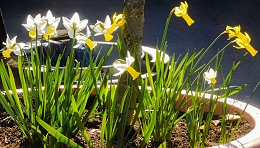
Sunlight through petals
Daffodils growing in spring
Bring joy to us all

Sunlight through petals
Daffodils growing in spring
Bring joy to us all
ST JOHNS CHURCH in Hampstead’s Church Row lies 0.1811 degrees west of the Greenwich Meridian. Its longitude is 0.1811 W. This fact is unimportant to most people living in the area because Hampstead is high above sea level. However, an accurate measurement of longitude (and latitude) is extremely important to seafarers.

I am no expert in navigation, so please excuse me if the following explanation seems oversimplified. Latitude can be assessed measuring the positions of fixed astronomical objects such as the sun and the North Star and relating them to the horizon. Longitude proved far harder to measure because it involves relating the local time to the time at a reference position, now at the commonly accepted Greenwich Meridian. The difference in the time at a position in the sea and that at Greenwich is the way that the calculation of longitude is made. Local time can be measured by means such as observing where the sun appears in the sky. Until the 18th century, no clocks existed that could reliably record the time at the reference position whilst at sea. The uncertainty involved in assessing longitude resulted in many unfortunate disasters at sea. In 1714, the British Parliament passed the Longitude Act of 1714, which offered prizes for a simple and practical method of assessing longitude out at sea.
To solve the problem, a clock that accurately recorded the time at Greenwich was required. This clock had to remain accurate despite the many changes that it would encounter as it moved across the seas. It had to record Greenwich Mean Time accurately and reliably despite changes in temperature, humidity, air pressure, motion of the vessel, and so on. Major advances in the solution of this demanding technical problem were made by a carpenter and clockmaker John Harrison (1693-1776), who was born near Wakefield in Yorkshire. For over 40 years, he worked on the problem, producing ever more reliable chronometers, which were tested at sea. Eventually, his H4 design became the prototype for what was best suited to the job. With the help of his son William Harrison (1728-1815), Harrison was rewarded with much of the financial reward offered in the wording of the Act passed in 1714.
When he died, John Harrison was living at his home in Red Lion Square in Holborn, whose longitude is 0.1186 W. He is buried in the same churchyard as the great artist John Constable: in the cemetery next to St Johns Church in Church Row, Hampstead. His tomb, which close to the south wall of the church, is of Portland stone and decorated with pilasters in the style of the architect Robert Adam. The north side of this shoebox shaped monument has an inscription that gives a brief biography of John Harrison. His wife, Elizabeth, who died in 1777, aged 72, is also commemorated on this tomb. The south side gives a short biography of his son William, who is also buried here. In addition to helping his father test his chronometer, he was also a Governor of the Foundling Hospital in London and High Sheriff of Monmouthshire (in 1791).
According to Christopher Wade in his “Buried in Hampstead”, several persons, who were not resident in Hampstead were interred in the churchyard of St John. The Harrisons figure amongst these. Wade states that there is no evidence that John Harrison and his family had any connection with Hampstead. He speculates that they obtained a burial plot there because they were “… affected by the charm of this particular graveyard.”
The graveyard still retains its charm. It contains the resting places of many people, who have achieved fame in diverse fields of activity. Some of them are mentioned in my new book about Hampstead, which is available as a paperback from Amazon (https://www.amazon.co.uk/dp/B09R2WRK92) and as a Kindle e-book.

THE VICTORIAN GOTHIC Westbourne Grove Church (with a Baptist congregation) is on the corner of the Grove and Ledbury Road. Built on the site of an earlier church, this building was constructed in 1866. On examination, it is obvious that it has been modified considerably. According to the church’s website, westbournegrovechurch.org, in 2001:
“… the church worked with the Manhattan Loft Corporation to redevelop the site. Our vision was to use the church building to serve the local community, as an expression of God’s generosity and love. The church retains space spread over the entire ground and first floors of the building, while the project was funded by development of apartments in the top four floors of the converted building.”
The church now shares its building with retail outlets and residential units, the rents from which help finance the church’s activities and maintenance.
The parts of the ground and first floors used by the congregation have been redesigned imaginatively and beautifully in a simple contemporary idiom. Airy spaces simply but attractively decorated, flow neatly between each other giving the interior of the church a cubist sculptural feel. The rooms at the base of the two towers on the south façade of the church are used for exhibitions and meetings. In short, the spaces used for ecclesiastical and pastoral purposes provide a wonderful example of successful modern interior design. The current vicar is Chris Thackery. His wife Charlotte is an architect, and was involved in overseeing, and advising on, the modernisation of the church.
A visit to see this wonderful new church is well worth making. It is not far from Portobello Road and is a treat for lovers of imaginative architectural design.
UNDOUBTEDLY THE CATHEDRAL in Salisbury (Wiltshire) is the city’s ‘star’ attraction and is worthy of many visits. However, the city has other things that should not be missed. One of these is the Parish Church of St Thomas (and St Edmund), about 370 yards north of the cathedral.
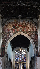
The present church was built from the 15th century onwards. Its detailed history can be found on the church’s website (https://stthomassalisbury.org.uk/wp-content/uploads/2021/06/BriefHistory.pdf). On entering the church from its western end, one cannot avoid seeing the colourful wall painting above the chancel arch. This is the Doom Painting, which depicts The Last Judgement. Images such as these used to be common in Christian Europe but are rare today. ‘Doom’ means ‘judgement’ in Anglo-Saxon. The painting in St Thomas is thought to have been created in about 1470 in the Flemish style by an English painter.
During the Reformation, the painting was covered over with whitewash in 1593. It remained hidden until 1819 when faint traces of colour began to appear when the wall was being cleaned. The painting was carefully uncovered in 1881, and then it was restored. In 1953, the image was cleaned again and retouched. Since then, it has remained untouched. Although it has been restored, it gives a good idea of how this superb fresco looked when it was first created.
While looking up at the Doom Painting, you should also examine the decorated timber ceilings above the nave and other parts of the church. These contain almost 100 wood carvings of angels. Also of interest, is a wooden panel on the wall of the south aisle. This bas-relief wood carving depicts Abraham sacrificing his son Isaac and Jacob’s Dream. It was created in about 1660 by the master Joiner Humphry Beckham (1589-1671).
There are plenty of other interesting items to see in the church, which deserves a visit. Had there not been a famous cathedral in Salisbury, this smaller church would have become one of the place’s main attractions.
AL SAQI BOOKSHOP in London’s busy Westbourne Grove occupies a shop with a façade that would not look out of place on a palazzo on the Grand Canal in Venice. I have already described the interesting history of this building elsewhere (https://adam-yamey-writes.com/2020/10/18/the-story-of-a-bookshop/).

Further west along the Grove, well past the Planet Organic ‘wholefood’ store and Alounak, one of the Grove’s several Persian restaurants, we reach number 62-64, whose façade is almost as grand as that of Al Saqi. Unlike the latter, this building’s history is harder to ascertain. Currently, it is the premises of Aveda, a beauty salon also called Gina Conway Salon Spa. The ground floor façade of this edifice includes neoclassical columns with Doric capitals, and decorative mouldings, which include the letters ‘C’, ‘L’, and ‘M’. These are intertwined to form a logo. The first floor is fronted by three large arches separated by decorative mouldings and the top storey has three sets of windows set back behind lintels supported by short columns with Doric capitals. The salon, although modernised to suit its current purpose, has its original elaborately decorated moulded plaster ceiling and wall mouldings, some of which depict the heads of angels or putti. Nobody in the salon had any ideas about the history of this attractive building.
A photograph in the London Metropolitan Archives describes number 62 as having an Edwardian façade. When this image was created in 1974, the building was a branch of the Midland Bank, which occupied its western two thirds. The eastern third of the place was the premises of The French Kitchen and Tableware Supply Company. The bank was already in existence at this address in 1940. What was there before the bank occupied the edifice and when exactly it was built, I have not yet discovered. The building is marked as a bank on a detailed map surveyed in 1914, but not on one surveyed in 1893. However, Allan & Mortons Street Directory of 1867 revealed that number 62 was then the address of Dr Barry, who practised homeopathic medicine. Both the 1893 and the 1914 maps mark the building west of number 62-64 on the corner of the Grove and the western arm of Newton Road as being a bank at those times. This building currently houses Farmacy, a vegan eatery.
The logo ‘LCM’ on the old bank stands for ‘London, City, and Midland’, a bank founded in 1898, which was renamed the London Joint City and Midland Bank in 1918 and then the Midland Bank in 1923 (www.gracesguide.co.uk/London_City_and_Midland_Bank). In the absence of any more information and in view of the fact that the architectural historian Pevsner regarded it as “Edwardian”, it might be safe to conclude that the present building at 62-64 Westbourne Grove was originally constructed to house a bank sometime during the reign of Edward VII, i.e., between 1901 and 1910, and certainly before 1918.
THE BOSTON TEA Party in Salisbury’s High Street serves great coffee and tasty breakfast dishes. It is housed in the premises of what used to be The Old George Inn. This hostelry is in a building, whose construction is said to have begun in the 14th century. Most of the older part of the former tavern straddles a pedestrian footway leading from the High Street to a modern shopping mall and its associated multi-storied car park.
The entrance to The Boston Tea Party is via a shop beneath a building that looks newer than the older looking half-timbered edifice straddling the passageway mentioned above. A staircase leads to a dining area above the shop, which is where we enjoyed breakfast one morning in March 2022. This room has a decoratively patterned plaster ceiling and the remains of an old inscription in gothic script. As we were leaving, I saw a notice that advised customers that if the section, where we ate, was closed, customers should proceed up to the ‘Great Hall’. I was intrigued.
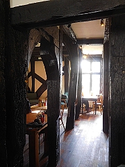
The Great Hall is one of the historical marvels of the city of Salisbury. Its ceiling is supported by beams cut from old ships’ timbers. The Inn has been rebuilt several times. However, the beams that exist today include wood from trees that were felled in the mid-15th century (www.buildingconservation.com/articles/george/inn_conservation.htm). Some of the walls are covered with wood panelling decorated with carvings and there are at least two elaborately carved wooden fireplace surrounds. Other decorative features include plasterwork covered with intricate bas-relief designs, and a lovely bow window overlooking the High Street. The hall is overlooked by a gallery with a balustrade. There is also a window with stained glass that includes a depiction of a royal coat-of-arms and the name of a king, probably Edward VI, who reigned from 1547 until 1553. According to the historicengland.org.uk website:
“On lst floor the south room has early C17 plaster work friezes on beams and carved wood overmantel. Projecting to east on north side open hall through 2 storeys. C15 hammerbeam roof, arched braces to collars. Heavy scissor bracing visible on 2nd floor lath decorated wall plates and spandrels. 2 rooms with tie beams and kingposts with 4-way struts.”
Over the centuries, The Old George Inn has had many visitors including William Shakespeare, Oliver Cromwell, Samuel Pepys, and Charles Dickens. It is believed that Shakespeare and his players, whilst on their way to Wilton, rehearsed “As You Like It” in the garden of the inn. Samuel Pepys spent one night at the inn but moved to another after having argued with the innkeeper over his bill.
Once upon a time, the Great Hall of the Old George Inn would have been filled with guests enjoying tankards of beer and ale and hearty meals. Today, in its reincarnation as The Boston Tea Party, the place is bustling with customers drinking cappuccinos and chai lattes as the consume trendy delicacies such as poached eggs on smashed avocado and ‘The Vegan Boss’. Whether or not you are thirsty or hungry, a visit to the Great Hall is a ‘must’ before or after you have viewed the cathedral.
LONG, LONG AGO, the land where Torquay now stands was below the Equator in the southern hemisphere. Shifting of tectonic plates over the millennia has moved it to where it is now. Along with this migration, a series of caves has also reached this location but far beneath the town, about 1 mile northeast of the Torquay Harbour seafront. The cave network known collectively as Kents Cavern has been open to the public since 1952. What makes it fascinating is that archaeologists have found, amongst other things, the earliest known human remains in Britain. Three types of hominid have made, use of these caves: Homo heidelbergensis (thrived roughly 750,000 to 200,000 years ago), Homo neanderthalensis (thrived from 400.000 to 40,000 years ago), and Homo sapiens (that is us today: we have been around since about 300,000 years ago). The two earlier forms of hominid lived or sheltered in the caves. Now, we, the current edition of this type of primate, merely explore the caves as archaeologists, and visit them as tourists.
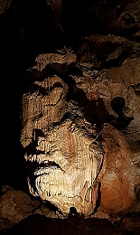
The earliest evidence of recent exploration of the caves is some inscriptions found within them. William Pete scratched his name on a stalagmite in 1571 and Robert Hedges did the same in 1688. Scientific exploration of the caves began in the early 19th century. In 1824, the geologist Thomas Northmore (1766-1851) made the first recorded excavation in 1824. Since then, others have made systematic archaeological excavations and discovered the remains of our early ancestors, their tools, and the remains of animals that sheltered in the caves. Two notable explorers of these underground passages and caverns are The Reverend John MacEnery (1796-1841) and William Pengelly (1812-1893). The latter established his reputation as an archaeologist by his discovery of the hominid remains in Kents Cavern. In addition, his discoveries helped in to prove that the biblical chronology of the earth was incorrect.
In 1903, the caves were acquired by a carpenter, Francis Powe, who used them as a workshop for constructing beach huts for the seafront in Torquay. His son, Leslie, converted them into a tourist attraction by installing electric lighting and laying down concrete paths. The caves are now run by a member of the family, Nick Powe.
At first sight, the visitor complex with its shop and café seems unexceptional and rather too ‘touristy’ for my liking. Visitors are escorted within the caves in groups led by a guide. The tourist facilities give little or no clue as to the wonders that await visitors after they step into the parts of the cave system that are on display. We were guided by a knowledgeable man, who was able to make geology and archaeology both palatable and extremely comprehensible to us. Even if you had had no interest in these subjects prior to going on the tour, he was able to sow seeds of interest in these subjects during the tour. Not only did he relate the facts clearly, but he was able to recreate in our minds the nature of life in the caves as it was when our ancestors illuminated them with lamps consisting of fat impregnated moss or other vegetable matter in scallop shells, and when enormous wild bears and other creatures hibernated or roamed about in these dark spaces. In addition, he pointed out interesting features of the geology of the caves including, stalagmites and stalactites in various stages of their continuing formation. Throughout the tour, our guide explained the difficulties that early explorers of the cave encountered.
To conclude, a visit to Kents Cavern is both visually spectacular and of great interest. Having seen the place, I would say that a visit to Devon must include a wander through these caves.
IN THE 1930s, both the sculptor Barbara Hepworth (1903-1975) and the painter Piet Mondrian (1872-1944) lived in Hampstead (north London). Hepworth and her two successive husbands lived and worked in the Mall Studios near Parkhill Road. Mondrian lived at 60 Parkhill Road. According to one of Hepworth’s biographers, Eleanor Clayton, writing in “Barbara Hepworth. Art and Life”:
“The beginnings of a friendship between Hepworth and Mondrian can be seen in her letters to Nicholson at the time: ‘so glad Mondrian said nice things about me & work. Goodness U did learn a LOT.’”
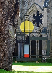
Visitors to the cloisters of Salisbury Cathedral can see an abstract sculpture at the southeast corner of the grassy space enclosed by them. At first sight, it looks like a sculptural version of a painting that might have been created by Mondrian. It is a sculpture by Barbara Hepworth called “Construction (Crucifixion)”. This bronze artwork was created in 1966, and then donated by the artist to the Cathedral in 1969. It is according to a notice by the sculpture:
“… Hepworth’s response to Christ’s Crucifixion …”
The interpretation of the piece’s symbolism is far from simple, as a website text (https://www.salisbury.anglican.org/news/the-crucifixion) explained:
“What we see are 3 verticals linked by a single horizontal bar, and by 2 other horizontals at different heights.
A large circle, attached to the intersection of the horizontal and vertical lines, is painted citrus yellow on one side and blue on the other. At the bottom of the central vertical, we see red on its own beneath the blue side of the circle, and red and white beneath the yellow. On the yellow side, a metal hoop encircles the point of crossing.
Hepworth wrote that she found it ‘very serene and quiet’, but that doesn’t have to guide what we make of this piece. We could see the yellow circle as the sun, the blue circle as the moon, the red paint as blood, the 2 verticals on either side as the crosses of the 2 men crucified with Jesus.
Or we could contemplate its hardness, weight, size (12ft tall and 2-and-a-half tons) and stark simplicity. We could seek to find meaning here, or we could stand before it and try to imagine the experience of meaningless horror and sheer emptiness which brutality of any kind must impose on those who witness it. For us, it need not seem ‘serene and quiet’ as for Hepworth. On the contrary this cross might confront us with the tragic lack of meaning which has so often afflicted humanity since the cross of Christ was first set up.”
Whatever its symbolism, Hepworth’s piece is attractive and looks good surrounded by the gothic architecture of the cloisters. Above all, its appearance immediately brings to mind thoughts about thw works of art created by Mondrian. One website (https://artistscollectingsociety.org/news/barbara-hepworth-sculpture-returns-salisbury-cathedral-permanent-display/) describes the piece as “Construction (Crucifixion): Homage to Mondrian” and then continued as follows:
“The sculpture is thought to explore the duality of Jesus Christ in its use of geometric symbols and features bold colours borrowed from the palette of ACS member Piet Mondrian, referenced in the artwork title.”
I was very pleased to see this work once again in March 2022, soon after publishing my book about Hampstead, past and present, in which I have included a substantial chapter about the modern artists who lived and worked in the area between the two World Wars. There is a good chance that Hepworth’s encounters with Mondrian and his work whilst they were both in Hampstead is reflected in the appearance of this abstract Crucifix, which stands in the cloisters at Salisbury.
PS My book, “Beneath a Wide Sky: Hampstead and its Environs” is available from Amazon (https://www.amazon.co.uk/dp/B09R2WRK92).
TORWOOD STREET RUNS downhill to the harbour of Torquay in Devon. This usually busy street is currently (March 2022) closed to vehicular traffic because it is undergoing repairs including resurfacing. During WW2, the street was resurfaced with concrete sufficiently strong to bear the weight of tanks and other heavy military vehicles that were making their way downhill to the harbour. One of our friends in Torquay told me that the current roadworks was partly to replace the concrete surface that was laid down in the 1940s. This US military equipment was on its way to the beaches of Normandy, where the invasion of German occupied France took place: the D Day Landings in 1944.

When these heavy vehicles reached the water’s edge, they had to be loaded onto boats. Concrete embarkation ramps were constructed in May 1943. They were used to load the equipment onto seagoing vessels in June 1944 to carry out Operation Overlord, which involved landing the US forces onto the Normandy coast. The concrete slipways, which have been preserved, were called ‘Embarkation Hards’. According to information displayed on a memorial close to the ‘hards’, the landing craft used in Operation Overlord operated a shuttle service between Torquay and the Normandy beaches. Soldiers of the 4th US Infantry Division, who embarked at Torquay, were amongst the 23000 troops who were landed at Utah Beach in Normandy. Along with them, 1700 tanks, guns, and trucks also arrived on that beach.
The ‘hards’, point of departure for Normandy, are not particularly attractive to look at, but they are an impressive souvenir of what was an important military operation, which in no little way helped to bring about the downfall of Hitler and the Nazi regime.
MOSES AND HIS followers crossed the Red Sea without difficulty. However, things were not so simple when a group of people were trying to cross the Atlantic to enjoy freedom to worship as they wished without persecution in North America in 1620 during the reign of England’s King James I. These travellers. the Pilgrim Fathers, were English Protestants, Puritans who had been living in the Low Countries in Leiden but felt that conditions there had become unfavourable for them. As they did not expect to live safely in England, they bravely set forth to sail to the New World.
The Pilgrim Fathers and their families left Holland in the “Speedwell” (60 tons) and after crossing the North Sea, their ship was joined by the larger “Mayflower” (180 tons), which was carrying Puritans fleeing from London. While heading west, the boats headed into trouble. On about the 23rd of August 1620, the two ships slipped furtively into Dartmouth in Devon and lay at anchor near to the town’s Bayards Cove, close to where today a small ferry carries vehicles and pedestrians across the River Dart between Dartmouth and Kingswear. The secrecy was necessary because as Puritans, the passengers risked punishment in England. They remained moored there until about the 31st of August while leaks on the “Speedwell” were being repaired.
After leaving Dartmouth to continue their voyage westwards, the “Speedwell” began leaking again. About 300 miles west-south-west of Lands’ End, the “Speedwell” had become almost unseaworthy. The boats returned to England, docking at Plymouth in Devon. There, the “Speedwell” was abandoned, and the “Mayflower” set sail for America with 102 passengers. The boat reached the harbour of Cape Cod in Massachusetts on the 21st of November 1620.
Although Plymouth is the place from which the Puritans finally left England, the point in the port from which they set off would now be unrecognisable to the Pilgrim Fathers were they able to see it. In contrast, although some of the buildings near Bayards Cove in Dartmouth have been built since the Pilgrim Fathers stopped there briefly, there remain sights that have not changed significantly since 1620.
