WHENEVER WE DRIVE to Cornwall, we make sure that we cross Dartmoor. Even if it means taking a detour along the narrow, challenging lanes of Devon, we always visit Combestone Tor. This geological formation, perched on the side of a hill commanding a panoramic view of well over 180 degrees, consists of several piles of enormous, weathered slabs of granite. Each pile has a few of these gigantic slabs piled one above the next. I have described how these impressive piles were formed in something I wrote a few years ago (https://adam-yamey-writes.com/2020/10/04/sculpted-by-nature/).
I cannot say why we find visiting Combestone Tor so satisfying. Is it the fine views over the moor and the countryside abutting it? Or is it the sculptural qualities of the rock formations? Could it be the peacefulness of the place? Even if there are other visitors at the Tor, one does not feel disturbed by them. Or is it the joy of seeing horses, sheep and cattle grazing near the stones? It is probably a combination of all of these, and other factors which affect one’s emotions, but are difficult to define. We have seen the Tor in appalling wind and rain and bright sunshine, and always feel glad that we have made the effort to reach the place.
MATTHEW KRISHANU WAS born in Bradford (UK) in 1980. His parents were Christian missionaries. His father was British, and his mother Indian. Their work took them to Bangladesh, where Matthew and his brother spent some of their childhood years. Matthew’s formal education in art took place at Exeter University, and then at London’s Central St Martin. Today, the 1st of June 2024, we viewed a superb exhibition of his paintings at the Camden Art Centre in Hampstead’s Arkwright Road. The exhibition continues until the 23rd of June 2024.
Many of the paintings on display include depictions of two young boys – the artist and his brother – often in a tropical setting that brings to mind places on the Indian Subcontinent. The paintings vary in size, but all of them are both pleasing to the eye and full of interest. His paintings of trees and other plants are impressionistic. Like many of the other pictures, they were inspired by the artist’s childhood in Bangladesh and later visits to India.
One room with several paintings contains works that must have been inspired by the artist’s memories of being brought up in a missionary family. The paintings in this gallery are depictions of the colonial legacy of Christianity in the Indian Subcontinent. Another indication of the artist’s upbringing in a Christian religious family setting is the appearance of small images of the Last Supper in several of the paintings, including those which are not specifically portrayals of religious environments.
Although, there is no doubt much that can be read into his paintings, Krishanu’s works are both approachable and engaging. I liked them immediately – as soon as I saw them. It is worth a visit to Arkwright Road to see this well laid-out exhibition.
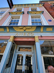
THE TOWN OF HERTFORD is full of delightful old buildings. A house on the town’s Fore Street has a façade decorated with features that bring to mind Ancient Egypt. Known as the Egyptian House, it was built in about 1825 for the grocer JM Gilbertson, who was Mayor of Hertford in 1832. In many ways it resembles a building with an Egyptian style façade. which I have seen in Penzance (Cornwall), This was constructed in about 1835. Both of the house in Hertford and that in Penzance were built later than the now no longer existing Egyptian Hall London’s Piccadilly, which was built in 1812, and was the inspiration for the Egyptian Revival Style of the later edifices in Hertford and Penzance.
The Egyptian House in Hertford is colourfully painted, as is the building in Penzance. Sadly, the Egyptian Hall in Piccadilly was demolished in 1905 to make space for the construction of a block of flats. The Egyptian Revival Style became fashionable during the time of the Egyptian campaigns (end of the 18th century) in the Napoleonic Wars.
Currently, Hertford’s Egyptian House is home to Anexo – a “tapas restaurant and charcuterie bar”. It serves fare that would have been unknown in Ancient Egypt. I wonder what the Pharaohs would have thought about a place like this.
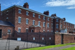
THE NATIONAL TRUST (‘NT’) maintains many buildings of great historic interest, and makes them accessible to the public. Most of the properties under the care of the NT are places where the well-off and the famous lived. Visitors to these homes and gardens can see finely decorated rooms. Often, the servant’s quarters are also displayed. This May (2023), we visited an unusual NT property in Nottinghamshire. Its distinctiveness lies in the fact that the buildings housed not the rich but the very poorest in society. Located at Southwell near Nottingham, it is the Southwell Workhouse.
The Workhouse was built in 1824 to house (usually temporarily) the poorest and most infirm people in the 49 parishes that made up Nottinghamshire’s Southwell Union, which financed the institution. Some of these people were impoverished during the advent of the Industrial Revolution in the early 19th century. For example, many households in the area made a living by making knitwear in their homes. When factories opened with industrial knitting machines, many of these artisans were left without work and income.
The Southwell Workhouse admitted people following assessment of their condition by a parish’s local Relieving Officer. The rather bleak Workhouse was divided into several separated sections: for women with children less than two years old; for women, both abled and disabled; for men, both able and disabled; boys aged 7 to 15; girls aged 7 to 15; and for other children, aged between 2 and 7 years. The children received elementary schooling in the Workhouse classroom; this improved their chances of obtaining employment. There was no mixing between men and women. Women worked mainly in the kitchens, which are in the cellars of the building. To avoid contact with men, who worked in the institution’s vegetable gardens, produce required for cooking was passed into the kitchens through hatches.
Except for the extremely infirm, the idea was to make the Workhouse as uncomfortable as possible so that the able-bodied inmates had an incentive to leave as soon as they felt able. Consequently, the food provided was dull and meagre. All able-bodied inmates had to work. Some of this work was either meaningless, like breaking stones, or physically difficult, like picking oakum. The maintenance of the institution was also carried out by the inmates. The Workhouse was designed to provide food and shelter for the most destitute, but not to make it so comfortable that they had no incentive to leave. By pooling their resources, the parishes in the Southwell Union saved money because without the workhouse each parish would have had to conform to legal requirements to set up their own facilities for looking after those at the bottom of the social pile. The Southwell Workhouse was an example of an economy of scale.
The Southwell Workhouse was the brainchild of the Reverend John Thomas Becher (1770-1848). A friend of Lord Byron, who wrote poems to him, Becher not only established the Workhouse, but four years later wrote a pamphlet, “The Antipauper System”. In this publication, he explained how successful the Workhouse was in reducing the “poor rates” by 75%. His work led to the establishment of other similar wirkhouses in the country following the passing of the Poor Law Amendment Act of 1834 (‘The New Poor Law’).
With the establishment of the NHS in 1948, the Workhouse became an institution run by a local authority and many things relating to the care of the poor changed in Britain. Until the 1970s, the Workhouse, re-named Greet House (after the River Greet), housed the poor, but ins slightly more comfortable conditions than were available to its earlier inmates. The NT has done a beautiful job of restoring the Southwell Workhouse. Arrows guide the visitor though the whole building. All along the route, NT volunteers greet you and explain what each room was used for and provide other fascinating background information. Although the Workhouse is a fairly grim looking place, a visit to it is extremely interesting and a dramatic contrast to the often-glittering, resplendent places that can be seen in the majority of NT properties.
SLEAFORD IS A SMALL town in Lincolnshire. I do not think it is on many tourists’ itineraries, and I am not sure that I would recommend it highly. However, on a positive note, everyone we met there was extremely friendly. Southgate Street is a vibrant shopping district with plenty of charity shops and places to eat and drink. At the south end of this thoroughfare, there is a gothic revival monument that towers over its surroundings. Shaped a bit like an Eleanor Cross or a shabby version of London’s Albert Memorial, it commemorates Henry Handley (1797-1846).
Henry was the son of a local banker and attorney, Benjamin Handley. He was educated at Charterhouse, Eton, Oxford, and Lincolns Inn. He married Caroline Edwardes, daughter of William Edwardes, 2nd Baron Kensington in 1825. He neither graduated at Oxford nor practised as a barrister. Three years later, he inherited his father’s estate. He served as a Whig Member of Parliament for Heylesbury in Wiltshire from 1820 to 1826. In 1826, he left Parliament and became a gentleman farmer near Sleaford. So far so good, but why does Sleaford have such an imposing monument to remember him?
Between 1832 and 1841, he was the elected MP for Lincolnshire South. According to an online article in “Lincolnshire World”, during this period:
“Henry, a father of 10, was a budding entrepreneur and his interest in agricultural affairs was always to the fore. During his time as MP for S. Lincolnshire … Henry opposed corn imports, championed steam power, and supported steam railways rather than canals. In 1842, Henry became President of the Royal Agricultural Society.”
So, it appears that Henry worked well for improving the prosperity of Lincolnshire. He proposed and carried out projects that would have helped both the locals and his own agricultural endeavours. In these things, the local people rated him as being so successful that after his death, they raised more than £900 to pay for the construction of his 65-foot-tall memorial in Sleaford. It was designed by the Birmingham architect William Boyle, and it remains a remarkably immodest landmark in a pleasantly modest town.
THERE IS AN OLD octagonal building in the market place of Somerton in Somerset. According to a website about the town, this building is:
“… the octagonal shaped market cross; also known as the Buttercross. This was built by the Stawell family in 1673 and given the parish council in 1916 … The market place was a busy and noisy area during market day, and in extremely hot weather the dairy products such as cheese, butter and milk would soon go off. These goods would also be ruined in wet weather, and so a shelter was required that would shade and cover the products from the weather conditions. The Buttercross was the ideal solution, as it was both cool and dry. It is now listed as a Grade II ancient monument, and has been repaired on a couple of occasions during the last century.” (from: http://www.somerton.co.uk/virtual-tour/market-cross/)
It is not the only octagonal structure in Somerton. The tower of the mediaeval parish church is also octagonal.
WHEN PEOPLE CONSIDER picturesque places in the eastern English county of Suffolk, the following places usually spring to mind: Bury St Edmunds, Clare, Southwold, Lavenham, Long Melford, and Sudbury. All these places deserve their reputation as sites worth visiting. Kersey is another place, which is exceptionally attractive. I had never heard about it until someone in a museum (in Essex) told me about it recently. It is far less visited than those mentioned above.
Kersey, Suffolk, England
Kersey is about 9 miles west of Ipswich. The village lies on the steep slopes of the valley of a small stream, a tributary of the River Brett (which feeds the River Stour). The main road running through Kersey crosses the stream not over a bridge but by a ford (known as ‘The Splash’). The village’s name, Kersey, means a ‘wet area with cress’. It is likely that this refers to the part of the place around The Splash. The heyday of the village was long ago: it was during the 14th century when Kersey was important in the then flourishing woollen cloth production industry. The church overlooking the village, St Mary’s, dates from that prosperous era. Likewise, with many of the lovely half-timbered houses. Although their construction began in the 14th and 15th centuries, they have undergone modifications over the centuries. However, they have a picturesqueness that easily rivals that which has made the better-known places (listed above) so famous.
Apart from the church and the half-timbered Bell Inn (about 14th century), one building stands out in Kersey. This is a large building with an impressive 16th century two storeyed red brick entrance structure projecting from the rest of the edifice, which was constructed in the 15th century. Above the main entrance, there is an inscribed stone plaque set into the brickwork. It bears the following: “Ye Olde River House 1490”.
After the Black Death (1346-1353) and later the decline of the wool industry in that part of Suffolk (in about the 17th century), not much happened in Kersey between then and the present, so I was told by a local inhabitant. Nothing much replaced the textile trade, and this led to the village remaining much as it was during its best days. This is lucky for those, like me, who enjoy the charm of England’s older and eye-catching vernacular architecture. Neither I nor the inhabitant with whom I spoke could understand why Kersey, unlike places such as I mentioned at the start of this piece, is not as frequently visited by tourists. Although smaller than all the other places, it easily matches their beauty.
MOSES AND HIS followers crossed the Red Sea without difficulty. However, things were not so simple when a group of people were trying to cross the Atlantic to enjoy freedom to worship as they wished without persecution in North America in 1620 during the reign of England’s King James I. These travellers. the Pilgrim Fathers, were English Protestants, Puritans who had been living in the Low Countries in Leiden but felt that conditions there had become unfavourable for them. As they did not expect to live safely in England, they bravely set forth to sail to the New World.
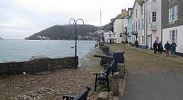
Bayards Cove
The Pilgrim Fathers and their families left Holland in the “Speedwell” (60 tons) and after crossing the North Sea, their ship was joined by the larger “Mayflower” (180 tons), which was carrying Puritans fleeing from London. While heading west, the boats headed into trouble. On about the 23rd of August 1620, the two ships slipped furtively into Dartmouth in Devon and lay at anchor near to the town’s Bayards Cove, close to where today a small ferry carries vehicles and pedestrians across the River Dart between Dartmouth and Kingswear. The secrecy was necessary because as Puritans, the passengers risked punishment in England. They remained moored there until about the 31st of August while leaks on the “Speedwell” were being repaired.
After leaving Dartmouth to continue their voyage westwards, the “Speedwell” began leaking again. About 300 miles west-south-west of Lands’ End, the “Speedwell” had become almost unseaworthy. The boats returned to England, docking at Plymouth in Devon. There, the “Speedwell” was abandoned, and the “Mayflower” set sail for America with 102 passengers. The boat reached the harbour of Cape Cod in Massachusetts on the 21st of November 1620.
Although Plymouth is the place from which the Puritans finally left England, the point in the port from which they set off would now be unrecognisable to the Pilgrim Fathers were they able to see it. In contrast, although some of the buildings near Bayards Cove in Dartmouth have been built since the Pilgrim Fathers stopped there briefly, there remain sights that have not changed significantly since 1620.
THE WALLS OF Bath Abbey are lined with memorials to the dead, many of whom are buried within the church. A remarkably large percentage of the funerary memorials commemorate the lives of people who worked in Britain’s colonies. There are monuments to people who lived and worked in the Caribbean, North America, and Asia, especially for the East India Company, which ‘ran’ and exploited India until 1858.
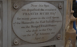
For example, Francis Mure Esq worked for many years in the civil service of “the Honourable the East India Company on the Bengal Establishment”. He died in Bath in 1810 aged 53. Henry Lynch Esq MD “of the island of Barbadoes” died in Bath in 1823, aged 49. Also from this place in the Caribbean was Benjamin Alleyne Cox Esq who died in Bath in 1802 aged 74. In 1812, 78-year-old Rawson Hart Boddam also died in Bath, after having served as the Governor of Bombay in 1784. Robert Brooke Esq, who had served in the Bengal Civil Service died in 1843 aged 72 is also interred in Bath Abbey. Peter Read Cazalet, “of the Honourable East India Madras Civil Service”, who died in 1859, aged 37, is yet another old ‘India hand’, who is buried in Bath. Also in the abbey are the remains of Major General Sir Henry White KCB, part of whose inscription reads chillingly like some of the news bulletins in the current Ukraine crisis: “The judicious Position taken by his Division in the Attack on Agra Which accelerated its fall And the Reduction of The Strong Hill Fort at Gwalior By Siege Are Proofs of Zeal and Military Skill…” He died in 1822.
What puzzled me was why did so many of these men from the colonies ended their lives in Bath. Was it because they were sick and had come to the place to take the curative spa waters, which failed to cure them? Or had they retired to Bath? Or, as someone suggested, Bath is close to Bristol, which was in many ways involved with colonial affairs.
The answers to these questions must remain uncertain at present. However, I wondered why the wealthy American Senator William Bingham died in Bath in 1804, aged 49. He was involved with the Barings Brothers bank in London, which might have been a reason for him being in England at the time of his death. He left for England in 1801, when his wife was taken ill. What he was doing in Bath remains unclear.
Amongst the many fascinating memorials in the Abbey are several commemorating people who died abroad. Some of these people had been in India when their lives ended. An interesting example of this, which illustrates the hazards of warfare and the difficulties in subduing people, who have no wish to be colonized, is the monument to 1st Lieutenant George Dobson Willoughby, of the Bengal Artillery and the Commisary of Ordnance at Delhi, who died in 1857. His inscription includes the following details: “As a brave and zealous soldier he stood firm in the defence of the post intrusted to him, and when resistance failed blew up the Delhi Magazine on 11: May 1857 to prevent it falling into the hands of the mutineers and rebels. Burnt and wounded he subsequently fell a prey to the insurgents …”
Maybe, this is a lesson from which the dutiful Russian soldiers in Ukraine should take heed.
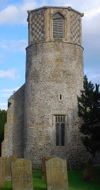
THE HELPFUL FEMALE voice with a North American accent emitting from our mobile ‘phone was quite persistent in trying to direct us onto the A47 road, the most direct route from Swaffham to Norwich, but we chose to ignore the advice we were being given. Instead, we forced ‘her’ to change her instructions so that we could follow a far longer but more pleasant route via Watton and Old Buckenham. As we wound our way between the two last mentioned places, we spotted a church with a round tower, made with flint and mortar, topped with a newer octagonal structure. This was in a Norfolk village that rhymes with freckles: Breckles. The church is St Margarets in the parish of Stow Bedon.
Churches with round towers are a rare breed in England compared with those with square towers. There are only 186 of the rounded versions (www.roundtowers.org.uk/) and some of them are in ruins. Of all the examples of this kind of church, the greatest number can be found in East Anglia, 131 of them in Norfolk. Church towers were built to house bells and sometimes the items used in services (e.g., church vessels). It is unlikely that they were built as part of the country’s defence against invaders because many of them were built after the last invasion of England (www.roundtowers.org.uk/about-round-tower-churches/).
“It has been suggested that the main reason was the lack of suitable local building material. Square towers require strong stone cut and dressed into blocks at each of the corners. But there is no suitable stone to be found in East Anglia and to transport stone from another county was very expensive for a small parish.
The only locally available stone was flint. Flint is a small, knobbly stone which, although creates strong walls when set in mortar, is not suitable for tower corners.”
The round tower of St Margarets was built in the 11th century (https://historicengland.org.uk/listing/the-list/list-entry/1248441), so could have been constructed either before or after 1066, when the Normans invaded. The octagonal structure on the top of the tower, the belfry, is late 15th century (www.norfolkchurches.co.uk/breckles/breckles.htm). Restored in 1856, the nave and chancel were constructed in the 15th and 14th centuries, respectively.
The interior of St Margaret’s is attractively simple. The carved, probably highly restored, wooden rood screen, separating the nave from the chancel, is one of the few decorative features in this small church. However, for me, the greatest attraction is the carved stone font, which is decorated with patterns and four carved figures standing in archways. The latter are carved in a simple, almost naïve or unsophisticated style, which made me wonder whether they date to pre-Norman times. Various sources describe it as being Norman. Whatever it is, it is a lovely piece of carving. When we saw it, it was decorated with flowers and foliage as part of the church’s preparations for celebrating the harvest season.
Having seen this charming church, we were pleased that we did not obey the voice on our GPS app, but instead took a route that our electronic navigator was initially so dead against. The more round about route allowed us to find a lovely church with a round tower.