
These steep white rocks
Fall into the briny channel
They’re England’s sharp edge
Photograph taken at Folkestone (Kent)

These steep white rocks
Fall into the briny channel
They’re England’s sharp edge
Photograph taken at Folkestone (Kent)
ALFRED LORD TENNYSON (1809-1892), the famous Victorian poet, had his home, Farringford House, at Freshwater Bay on the Isle of Wight. First, he rented the house in 1853, and then bought it in 1856. Because he was pestered by so many tourists, he moved to Aldworth in West Sussex in 1869. However, he kept Farringford, and spent most winters there. In 1860, his friend, the creative photographer Julia Margaret Cameron (1815-1879), bought a house, Dimbola, which was very close to Farringford.
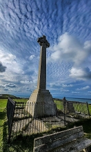
In 1897, a memorial to the poet was erected on Tennyson Down, a clifftop high above Farringford and Dimbola. Designed by JL Pearson, it is a tall stone Celtic cross mounted on a stepped base. A gently sloped footpath leads from Dimbola to the memorial, but we did not use this. Instead, my friend Martin and I laboriously climbed a steeper path closer to it. The cross is impressive and dramatic against the wide-open sky – almost Wagnerian. The views from the clifftop were magnificent on the clear day we visited it.
Our descent from the clifftop was somewhat adventurous. This was not intentional. Because we could not remember the place the path (and staircase), which we ascended, began, we had to create our own route down the steep, almost vertiginous, wooded slopes. We had to be careful not to trip over the numerous tree roots and fallen branches that were hidden under fallen leaves that lay all over the place. I was quite relieved when we reached the car park without having fallen or strained our ankles. Next time I visit the poet’s memorial, I will use the lengthier but safer footpath.
You can read more about Tennyson and Julia Margaret Cameron, “Between Two Islands. Julia Margaret Cameron and her Circle”, available from Amazon sites such as:
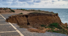
THE CAR PARK at Compton Bay on the south coast of the Isle of Wight is falling into the sea far below. The waves are undermining the cliff upon which the car park is situated. In conjunction with this, wind and rain are literally eating away the cliff. Where there had been a row of marked parking spaces, this has become unusable because the cliff has broken away. The markings are still visible, but they end abruptly at the fractured cliff edge. The local National Trust warden told us that next year, this disappearing car park will be closed and grassed over. A new one will have to be created further away from the clif edge. Seeing the damage being caused brought home how powerful are the forces of nature.
NEAR THE WESTERNMOST point on the Isle of Wight, lies Alum Bay. From its pebble beach, the Needles rock formation with their light house can easily be seen. Turn your back on the Needles and you will see that the bay and its beach have a backdrop of folded cliffs. These are not any old cliffs. They are multi-coloured.
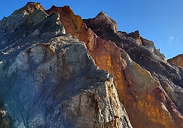
The colouration of the cliffs is caused by the presence of oxidised iron compounds formed under different conditions.
The beach from which the coloured cliffs can be seen can be reached two ways. Either by foot, using a series of staircases, or by travelling on a spectacular set of chairs suspended from cables: a sort of funicular. I recommend descending by foot to enjoy the views at leisure and returning using the chair lift. However, descending on the latter is also said to be an exciting experience.
MUCH OF FOLKESTONE, a seaside town in Kent, is perched on slopes leading down to cliffs overlooking the shoreline. The Leas, a wide promenade running along the top of the cliffs to the west of the centre of the town, affords fine views of the beaches and rocks far beneath it. Various staircases, a lift (out of action nowadays), and paths lead from The Leas down to the seashore and the park that runs alongside it. The most fascinating of these, The Zigzag Path, begins close to a cast-iron bandstand a few yards west of the statue of the scientist/physician William Harvey. I loved it so much that I walked down it three times in the three days we spent in Folkestone recently.

With five hairpin bends and a couple of short tunnels as well as blind ending caves, The Zigzag Path takes pedestrians down from the Leas at 150 feet above sea level to lower than 42 feet above the sea. The path is like a winding mountain road in miniature and provides endlessly changing views of the seashore and the trees and other vegetation growing near it. In more detail:
“The path is in five sections, and covers a substantial vertical area of about 75 metres across and 50 metres high. It incorporates steps, seats, plant pockets, low walls, and with tunnels, arches and caves at each turn.” (https://pulham.org.uk/2014/10/13/chapter-40-1920-21-the-leas-zigzag-path-folkestone-kent/).
The steep path was built for Folkestone Corporation in the early 1920s. The first attempt was not brilliant. So, the Corporation employed Mr Pulham of the company of James Pulham & Son, who specialised in the construction of rock gardens, follies, and grottoes (https://en.wikipedia.org/wiki/James_Pulham_and_Son). The company’s founder, James Pulham (1820-1898) was the inventor of a manmade (anthropic) rock-like material known as Pulhamite. This composite material simulates the appearance of natural rock so successfully that sometimes geologists are fooled by it. Pulhamite is a mixture of sand, Portland cement, and clinker, which is sculpted over a core consisting of rubble and crushed bricks (https://en.wikipedia.org/wiki/Pulhamite). The Zigzag Path was built with Pulhamite. While walking down the path, I spotted several places where the surface of the Pulhamite had worn away leaving fragments of brick exposed. If I had not seen this, I would have found it difficult to believe that the path was not created using natural rock. Recently, interesting ironwork railings have been added to the side of path facing the sea. These incorporate metal features that resemble plant tendrils wrapping around a support.
The wonderful Zigzag Path is just one of many of the Pulham’s ornamental creations. A full listing can be found in “Rock Landscapes: The Pulham Legacy: The Pulham Legacy: Rock Gardens, Grottoes, Ferneries, Follies, Fountains and Garden Ornaments” by Claude Hitching and Jenny Lilly. A visit to Folkestone would not be complete without experiencing the beautiful and rather fantastic Zigzag Path, preferably by descending it. If you decide to ascend it, you will have done sufficient exercise not to need to visit the gym that day.

Steep cliffs encroaching
The stream gathers speed
The Iron Gates loom ahead
The Iron Gates is a narrow defile or gorge through which the River Danube flows. One side of this attractively impressive canyon is formed by Romania and the other by Serbia. At one point, the two countries come so close to each other that they seem as though they are kissing. Where they come closest, there is a hydroelectric dam that was built during the Communist era.
My picture was taken from the Serbian shore in 1990, when Serbia was still part of Yugoslavia.
