Dwellings in Globe Town

ROMAN ROAD IN east London is a section of a road running northeast from Shoreditch. It is part of a Roman road, once known as ‘Pye Road’, which ran from London to Venta Icenorum that was near Norwich. The modern road passes through an area known as Globe Town, which lies just east of Bethnal Green Underground Station. Known as ‘Eastfields’ until the start of the 19th century, the area was then called Globe Town, probably because there was a pub with that name in the area. The area was developed in the late 18th century to accommodate French Huguenot and Irish silk weavers. The weavers had looms in their homes.

By the late 19th century, Globe Town had become an overcrowded slum. Then, there were not only weavers in this run-down district but also dockworkers and people considered to be disreputable: thieves, prostitutes, and vagrants.

At the start of the 20th century, some of the slum buildings were replaced by improved habitations. Some of these can be seen whilst walking along Globe Road, which runs north from Roman Road. The buildings along Globe Road were mainly constructed by the East End Dwellings Company (‘EEDC’) between 1900 and 1906. This philanthropic company was founded in 1882 to create model dwellings. One of its founding fathers was the vicar of St Judes Church in Whitechapel, Samuel Augustus Barnett (1844-1913). Samuel and his wife Henrietta Barnett (1851-1936) unwittingly played an important role in my childhood and early adulthood. For, it was their idea to create the Hampstead Garden Suburb (in north London), where I lived for almost 30 years. Interestingly, the Anglican church in the Suburb is also dedicated to St Jude.

The aim of the EEDC was to house the poor economically, yet not without making some modest profit. The company’s first project was Katharine Buildings in Aldgate, which were opened in 1885. The buildings in Globe Road were completed between 1900 and 1906 and are still in use. Apart from the EEDC buildings, Globe Road offers the visitor a few other treats. One of these is The Camel pub, whose menu includes a range of pies. Nearby is another pub, The Florist Arms, which offers stone-baked pizzas.  If these food items are not to your taste, The Full Monty Café offers tasty snacks, Opposite the latter, there is a small second-hand bookshop, which raises money for a Buddhist organisation. The London Buddhist Centre is housed on the corner of Globe and Roman Roads. A short distance east of Globe Road, Roman Road crosses the Regents Canal, which is flanked on its east side by pleasant parks.  

Threatened by Heathrow Airport

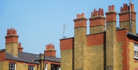
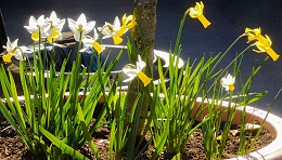
THE PARISH CHURCH of Harmondsworth is about 1.7 miles northwest of Heathrow Airport’s Terminal 1, yet it feels as if it were much further from it, maybe in the heart of the countryside. What was once a small village in rural Middlesex has now been engulfed by London’s westward spread. However, the old village green retains a certain rustic charm.

The name of the place derives from the name of a person, ‘Hermode’ or ‘Harmond’ and the Anglo-Saxon word ‘worth’ meaning a farm or enclosure. Set in what was once fertile farmland that provided corn and green crops for the London markets, it is now a mainly residential area. Writing in 1876 in his “Handbook to the Environs of London”, James Thorne remarked:

“The village of Harmondsworth is small and not remarkable …”

Writing 146 years later, I must disagree. The place is remarkable for retaining some of its rural atmosphere. The village green is surrounded by a row of picturesque old cottages, a slightly newer-looking village store (Gable Stores), and two pubs (The Crown and The Five Bells [formerly ‘The Sun’]), and the entrance to the churchyard of the parish church of St Mary.

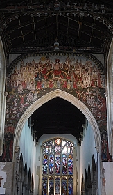
The vicar of St Mary kindly unlocked the church for us. According to a history of the church by Douglas M Rust, it is probably located near the site of a pagan place of worship on one of the quintarial lines defined by Roman surveyors’ landmarks. The archaeologist Montagu Sharpe, writing in volume 33 of the “English Historical Review”, published in 1918, observed:

“Two curious discoveries came to light after the quintarial cross-lines had been drawn, making each pagus appear like a gigantic chequer-board. The first was, that 47 out of 56 mother churches of parishes in Middlesex were situated upon one or other of these lines, the apparent explanation being that Romano-British chapels (compita) adjoined the principal rural ways, which were designed to follow the quintarial lines. In the next age these little edifices were adopted by missionaries for Christian worship, following the astute and well-known direction of Pope Gregory to utilize the pagan sacra where the people had been accustomed to assemble. If so, then such sites have been associated with public worship, first pagan, then Christian, for nearly 2,000 years.”

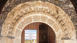
Be that as it may, the present parish church in Harmondsworth was constructed from the 12th century onwards, much of it before the 16th century. In the 18th century, a cupola was added to the bell tower. In the following century, repairs and restoration was undertaken. The south entrance has a decorated carved stone Norman archway. The carved capitals of the pillars on the south side of the nave are 12th century. The westernmost pillars on the north side of the nave are 13th century, whereas the four pillars to the east of these are 16th century. The chancel, which is supported by the newer pillars was constructed later than the nave. Where the newer part was joined to the older, there is a discontinuity in the stonework of the arch that joins the nave to the chancel: the two halves of the arch do not match each other. The pointed arches along the north side of the nave are Perpendicular gothic in style, whereas those north of the chancel are a Tudor design.

The tower of the flint covered church used to be the tallest building in Harmondsworth until the control tower at nearby Heathrow Airport was constructed, Douglas Dark mentioned of the church:

“Little did the early builders realise that their church was later to become the parish church of the manor where many visitors to Britain first arrive.”

A few yards northwest of the church, there is another treat awaiting visitors to Harmondsworth. This is the Harmondsworth Barn, which was constructed 1425-27 on land bought in 1391 by William of Wykeham (c 1320-1404), Bishop of Winchester, to endow Winchester College. It is now maintained by English Heritage, from whose website I gleaned the following information:

“Used mainly to store cereal crops before threshing, it remained in agricultural use until the 1970s. At 58 metres (192 ft) long and 11.4 metres (37 ft 6 in) wide, the barn is one of the largest ever known to have been built in the British Isles, and the largest intact medieval timber-framed barn in England.”

The barn’s main purpose was to store locally grown cereals (e.g., wheat, barley, and oats) and was still in use during the 1970s. Its interior is a fine example of well-preserved mediaeval carpentry. The barn is located on the eastern edge of what was once Manor Farm, through which a stream of the River Colne flowed. The erstwhile farm covered the probable site of a long-since demolished Benedictine Priory.

James Thorne noted that the barn had once been ‘L’ shaped, rather than rectangular as it is today. The part of it that had made it shaped like an ‘L’ was taken away and relocated elsewhere. To quote Thorne:

“This wing was taken down about the same time as the Manor House and rebuilt at Heath Row, 1 ½ miles S.E. of Harmondsworth church. This, which is known as the Tithe Barn, exactly resembles the Manor Barn in structure, except the walls are of brick…”

Well, ‘Heath Row’ is now ‘Heathrow’ and this fragment removed from the barn at Harmondsworth no longer exists. I located it on a map surveyed in 1862. It then stood on a road or lane that ran south from the Bath Road to Perry Oaks Farm on the western edge of Heathrow village. This land is now covered by the airport terminals (1,2, and 3).

Harmondsworth village has a few other old buildings apart from those already mentioned. One of them is Harmondsworth Hall, which Wendy Tibbits described in her blog (www.wendytibbitts.info) as follows:

“This grand-sounding building was built in the early 1700s, but still has elements of a fire-damaged Tudor building which was on this site. The central chimney and a fireplace are remnants of the former hous. … In 1910 this house was the first house in Harmondsworth to have its own electricity supply.”

Both Ms Tibbits and the vicar of the parish church fear for the future of Harmondsworth should plans to extend Heathrow Airport are carried out. Most of the old village will be demolished, leaving the church and the barn. Ms Tibbits noted:

“If the London Airport Expansion plans go ahead eleven listed buildings in Longford, and twelve in Harmondsworth will be demolished, along with hundreds of other homes. Only Harmondsworth medieval Great Barn and its Norman church will survive the destruction, but who will want to visit them when they will be meters from the airport’s perimeter fence?”

Although extending the airport might benefit the country, it would be sad to lose yet more of Britain’s heritage.

Czech it out

JAN GARRIGUE MASARYK was born in Prague (Czechoslovakia) in 1886. Son of the first President of Czechoslovakia, Tomáš Garrigue Masaryk (1850-1937), Jan was Foreign Minister of his country between 1940 and 1948, when two things happened. First, the Communists began tightening their grip on Czechoslovakia and possibly connected with that, Jan Masaryk was found dead in his pyjamas in the courtyard of the Foreign Ministry in Prague on the 10th of March. By 1948, Prague already had a reputation for defenestration. Whether or not Jan was pushed out of a window remains uncertain. Two years earlier, a large non-descript house in Hampstead’s West End Lane became home to the recently formed National House, a meeting place for Czechoslovaks (mainly war veterans) in London. Now, it is known as Bohemia House. Its website (https://bohemiahouse.london/beginning-of-national-house/) explains:

“After communist revolution in 1948 and the USSR invasion to Czechoslovakia in 1968, providing the homely atmosphere as well as traditional cuisine. Converted into public house in mid 80’s, the National House serves also as a traditional restaurant showcasing Czech & Slovak cuisines to the public.”

It was in the 1980s that I first began visiting the place to sample Czechoslovak food and drink. After many years, I revisited the place recently (in March 2022).

If it were not for the sign advertising Pilsner Urquell beer projecting above a tall privet hedge, most passers-by would hardly notice that they were passing what is now a bar and restaurant. Immediately after entering via the front door, I noticed several commemorative plaques. One of them honours the British historian RW Seton-Watson (1879-1951), who fought for the rights of the Czechs and Slovaks and other subject people/nations of the former Austro-Hungarian Empireafter WW1. Next to that, there is a large metal plate remembering the Czechoslovak “soldiers, airmen, and patriots”, who fell in WW2. It makes special mention of the Czechoslovak men who flew from Leamington Spa and were parachuted into their Nazi-occupied country to assassinate Heydrich (see https://adam-yamey-writes.com/2021/11/25/leamington-spa-heydrich-and-the-tragedy-at-lidice/).

A doorway from the hallway leads into a front room used as a formal dining room. This is decorated in a mildly baroque style. A gold-framed portrait of TG Masaryk faces the door. Various other framed portraits including one of Queen Elizabeth II hang on the walls. A metal bust of TG Masaryk stands on a mantlepiece next to a credit card machine and a metal sculpture of a Czech airman and there is an old-fashioned gramophone with an LP on its turntable between the two metal sculptures. The formal dining room is separated by a folding screen from a much larger room behind it. The latter, with tables and chairs, a pool table, and a table-football unit, is a less formal space, which I do not remember from the 1980s. In those days, food was served to ‘outsiders’ in the formal front room.

The larger, rear room with windows overlooking the back garden has several interesting objects on its walls. A sombre-looking metal plate covered with many names lists those who “gave their lives for Freedom” between 1939 and 1945. On the wall facing this, there are two posters with photographs of Alexander Dubček (1921-1992), a Slovak Communist politician, who tried to reform the Communist government during the Prague Spring of 1968, which ended after a few months when the Soviet Army invaded his country. On a wall behind the table-football unit, there are two large, colourful, framed maps. One is of the Czech Republic and the other of the Slovak Republic. Between the end of WW1 and 1993, the two now independent countries were parts of one country: the former Czechoslovakia.

A visit to the toilet involves climbing the stairs to the first floor. After ascending the first flight of stairs, the next short flight approaches a huge painting depicting TG Masaryk dressed in a flowing light beige coat and sporting a straw hat with a black ribbon tied above its rim.

Today, Bohemia House continues to welcome guests, both from the lands, which were once Czechoslovakia, as well as others. Its bar offers a range of beers, spirits, wines, and soft drinks, from that region of Central Europe. I sampled a can of Kofola, a carbonated Czech soft drink, whose taste vaguely resembles Coca Cola. The pint of Pilsner Urquell beer was more enjoyable. We also tried a variety of dishes typically cooked in the Czech and Slovak republics. They were enjoyable enough, but I prefer the cuisines of both Poland and Hungary. However, do not let this comment put you off paying a visit to Bohemia House, where you will receive a warm welcome from its charming staff. And … if you wish to know more about Hampstead’s Czechoslovak, other Central European, and Soviet historical associations, you could do no better than to read my new book about the area, available from Amazon [https://www.amazon.co.uk/dp/B09R2WRK92] and bookdepository.com [https://www.bookdepository.com/BENEATH-WIDE-SKY-HAMPSTEAD-ITS-ENVIRONS-2022-Adam-Yamey/9798407539520]).

An old bus evokes memories

SEEING A VINTAGE London bus today (20th of March 2022) brought back some memories from the early 1960s.  In those days, my best friend was the son of a medical doctor who worked for London Transport. Nick and I were about 10 years old when we became keen bus spotters. This involved loitering in the open-air bus station at Golders Green station with pencils and notebooks at the ready. As buses arrived in the forecourt, we noted down their serial numbers, which are visible on the sides of the bus or, in some older models, on their engine covers. These differed from the vehicles’ registration numbers. The serial numbers of different models of bus consisted of 1 to 3 letters and up to four numerals, e.g., RF 645 or RLH 24. Routemaster buses, which were replacing older models in the 1960s had serial numbers that began with ‘RM’ or in the case of the extended versions ‘RML’. The double-decker RMs were gradually replacing their predecessors, the RT models (which were in use in London from 1939 to 1979). Although we recorded every bus that passed us, certain examples, e.g., RT5 and RM1, were rare and exciting observations. The two of us and my friend’s younger brother formed the short-lived ‘OBC’, the Omnibus Club, of which we were the only members.

Now in 2022, long after the OBC disbanded, the Routemasters have largely disappeared from London, having been replaced by newer models. So, it was with some surprise that I spotted a RT bus in pristine condition parked in Notting Hill Gate today. For those bus spotters reading this, the vehicle bore the serial number RT1705. It was carrying the route number 28, with its destination board showing “Golders Green”. Today, route 28 still exists, but no longer runs from Chelsea to Golders Green (via Notting Hill Gate and West Hampstead) as it did in the ‘60s. In those days I had a friend who lived in Notting Hill Gate and used to visit him from Golders Green, using that bus route. Today, the same journey can be made using a bus on route 328.

The RT, which I saw today, was being used for private hire. As we were about to travel to West Hampstead, my wife asked the driver if he was going there later. He said he was, but he was not insured to take passengers who were not members of the party which had hired the bus. That was a pity, but as a former bus spotter, who gave up the hobby many decades ago, I was excited to see an RT still working on a London street,

Hampstead lies slightly west of the Greenwich Meridian

ST JOHNS CHURCH in Hampstead’s Church Row lies 0.1811 degrees west of the Greenwich Meridian. Its longitude is 0.1811 W. This fact is unimportant to most people living in the area because Hampstead is high above sea level. However, an accurate measurement of longitude (and latitude) is extremely important to seafarers.

Tomb of the Harrison family in Hampstead

I am no expert in navigation, so please excuse me if the following explanation seems oversimplified. Latitude can be assessed measuring the positions of fixed astronomical objects such as the sun and the North Star and relating them to the horizon. Longitude proved far harder to measure because it involves relating the local time to the time at a reference position, now at the commonly accepted Greenwich Meridian.  The difference in the time at a position in the sea and that at Greenwich is the way that the calculation of longitude is made. Local time can be measured by means such as observing where the sun appears in the sky. Until the 18th century, no clocks existed that could reliably record the time at the reference position whilst at sea. The uncertainty involved in assessing longitude resulted in many unfortunate disasters at sea. In 1714, the British Parliament passed the Longitude Act of 1714, which offered prizes for a simple and practical method of assessing longitude out at sea.

To solve the problem, a clock that accurately recorded the time at Greenwich was required. This clock had to remain accurate despite the many changes that it would encounter as it moved across the seas. It had to record Greenwich Mean Time accurately and reliably despite changes in temperature, humidity, air pressure, motion of the vessel, and so on. Major advances in the solution of this demanding technical problem were made by a carpenter and clockmaker John Harrison (1693-1776), who was born near Wakefield in Yorkshire. For over 40 years, he worked on the problem, producing ever more reliable chronometers, which were tested at sea. Eventually, his H4 design became the prototype for what was best suited to the job. With the help of his son William Harrison (1728-1815), Harrison was rewarded with much of the financial reward offered in the wording of the Act passed in 1714.

When he died, John Harrison was living at his home in Red Lion Square in Holborn, whose longitude is 0.1186 W. He is buried in the same churchyard as the great artist John Constable: in the cemetery next to St Johns Church in Church Row, Hampstead. His tomb, which close to the south wall of the church, is of Portland stone and decorated with pilasters in the style of the architect Robert Adam. The north side of this shoebox shaped monument has an inscription that gives a brief biography of John Harrison. His wife, Elizabeth, who died in 1777, aged 72, is also commemorated on this tomb. The south side gives a short biography of his son William, who is also buried here. In addition to helping his father test his chronometer, he was also a Governor of the Foundling Hospital in London and High Sheriff of Monmouthshire (in 1791).

According to Christopher Wade in his “Buried in Hampstead”, several persons, who were not resident in Hampstead were interred in the churchyard of St John. The Harrisons figure amongst these. Wade states that there is no evidence that John Harrison and his family had any connection with Hampstead. He speculates that they obtained a burial plot there because they were “… affected by the charm of this particular graveyard.”  

The graveyard still retains its charm. It contains the resting places of many people, who have achieved fame in diverse fields of activity. Some of them are mentioned in my new book about Hampstead, which is available as a paperback from Amazon (https://www.amazon.co.uk/dp/B09R2WRK92) and as a Kindle e-book.

A church transformed

THE VICTORIAN GOTHIC Westbourne Grove Church (with a Baptist congregation) is on the corner of the Grove and Ledbury Road. Built on the site of an earlier church, this building was constructed in 1866. On examination, it is obvious that it has been modified considerably. According to the church’s website, westbournegrovechurch.org, in 2001:

“… the church worked with the Manhattan Loft Corporation to redevelop the site. Our vision was to use the church building to serve the local community, as an expression of God’s generosity and love. The church retains space spread over the entire ground and first floors of the building, while the project was funded by development of apartments in the top four floors of the converted building.”

The church now shares its building with retail outlets and residential units, the rents from which help finance the church’s activities and maintenance.

The parts of the ground and first floors used by the congregation have been redesigned imaginatively and beautifully in a simple contemporary idiom. Airy spaces simply but attractively decorated, flow neatly between each other giving the interior of the church a cubist sculptural feel. The rooms at the base of the two towers on the south façade of the church are used for exhibitions and meetings. In short, the spaces used for ecclesiastical and pastoral purposes provide a wonderful example of successful modern interior design. The current vicar is Chris Thackery. His wife Charlotte is an architect, and was involved in overseeing, and advising on, the modernisation of the church.

A visit to see this wonderful new church is well worth making. It is not far from Portobello Road and is a treat for lovers of imaginative architectural design.

Doom painting

UNDOUBTEDLY THE CATHEDRAL in Salisbury (Wiltshire) is the city’s ‘star’ attraction and is worthy of many visits. However, the city has other things that should not be missed. One of these is the Parish Church of St Thomas (and St Edmund), about 370 yards north of the cathedral.

The Doom Painting

The present church was built from the 15th century onwards. Its detailed history can be found on the church’s website (https://stthomassalisbury.org.uk/wp-content/uploads/2021/06/BriefHistory.pdf). On entering the church from its western end, one cannot avoid seeing the colourful wall painting above the chancel arch. This is the Doom Painting, which depicts The Last Judgement. Images such as these used to be common in Christian Europe but are rare today. ‘Doom’ means ‘judgement’ in Anglo-Saxon. The painting in St Thomas is thought to have been created in about 1470 in the Flemish style by an English painter.

During the Reformation, the painting was covered over with whitewash in 1593. It remained hidden until 1819 when faint traces of colour began to appear when the wall was being cleaned. The painting was carefully uncovered in 1881, and then it was restored. In 1953, the image was cleaned again and retouched. Since then, it has remained untouched. Although it has been restored, it gives a good idea of how this superb fresco looked when it was first created.

While looking up at the Doom Painting, you should also examine the decorated timber ceilings above the nave and other parts of the church. These contain almost 100 wood carvings of angels. Also of interest, is a wooden panel on the wall of the south aisle. This bas-relief wood carving depicts Abraham sacrificing his son Isaac and Jacob’s Dream. It was created in about 1660 by the master Joiner Humphry Beckham (1589-1671).

There are plenty of other interesting items to see in the church, which deserves a visit. Had there not been a famous cathedral in Salisbury, this smaller church would have become one of the place’s main attractions.

From bank to beauty parlour

AL SAQI BOOKSHOP in London’s busy Westbourne Grove occupies a shop with a façade that would not look out of place on a palazzo on the Grand Canal in Venice. I have already described the interesting history of this building elsewhere (https://adam-yamey-writes.com/2020/10/18/the-story-of-a-bookshop/).

62-64 Westbourne Grove, London

Further west along the Grove, well past the Planet Organic ‘wholefood’ store and Alounak, one of the Grove’s several Persian restaurants, we reach number 62-64, whose façade is almost as grand as that of Al Saqi. Unlike the latter, this building’s history is harder to ascertain. Currently, it is the premises of Aveda, a beauty salon also called Gina Conway Salon Spa.  The ground floor façade of this edifice includes neoclassical columns with Doric capitals, and decorative mouldings, which include the letters ‘C’, ‘L’, and ‘M’. These are intertwined to form a logo. The first floor is fronted by three large arches separated by decorative mouldings and the top storey has three sets of windows set back behind lintels supported by short columns with Doric capitals. The salon, although modernised to suit its current purpose, has its original elaborately decorated moulded plaster ceiling and wall mouldings, some of which depict the heads of angels or putti.  Nobody in the salon had any ideas about the history of this attractive building.

A photograph in the London Metropolitan Archives describes number 62 as having an Edwardian façade. When this image was created in 1974, the building was a branch of the Midland Bank, which occupied its western two thirds. The eastern third of the place was the premises of The French Kitchen and Tableware Supply Company. The bank was already in existence at this address in 1940.  What was there before the bank occupied the edifice and when exactly it was built, I have not yet discovered. The building is marked as a bank on a detailed map surveyed in 1914, but not on one surveyed in 1893. However, Allan & Mortons Street Directory of 1867 revealed that number 62 was then the address of Dr Barry, who practised homeopathic medicine.  Both the 1893 and the 1914 maps mark the building west of number 62-64 on the corner of the Grove and the western arm of Newton Road as being a bank at those times. This building currently houses Farmacy, a vegan eatery.

The logo ‘LCM’ on the old bank stands for ‘London, City, and Midland’, a bank founded in 1898, which was renamed the London Joint City and Midland Bank in 1918 and then the Midland Bank in 1923 (www.gracesguide.co.uk/London_City_and_Midland_Bank). In the absence of any more information and in view of the fact that the architectural historian Pevsner regarded it as “Edwardian”, it might be safe to conclude that the present building at 62-64 Westbourne Grove was originally constructed to house a bank sometime during the reign of Edward VII, i.e., between 1901 and 1910, and certainly before 1918.