I am always fascinated by the contrasts between old and new buildings positioned close to one another.
A city evolves
The new is built close to the old
In London town

I am always fascinated by the contrasts between old and new buildings positioned close to one another.
A city evolves
The new is built close to the old
In London town
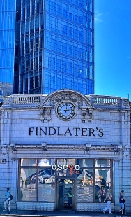
THERE IS A SHORT crescent lined with elegant residential houses near to the Kensington Temple church close to the centre of London’s Notting Hill Gate. A few yards west of this there is a short cul-de-sac called Horbury Mews. The crescent also bears the name Horbury. Although I have passed them often, it was only today that I wondered about ‘Horbury’.

Both the Crescent and the Mews were built on land that was leased to William Chadwick in 1848 by Felix Ladbroke, heir of the property developer and landowner James Weller Ladbroke (died 1847). William, a developer, built many houses on the Ladbroke Estate in Kensington. His heir WW Chadwick constructed the houses on Horbury Crescent between 1855 and 1857. The mews nearby bear the date 1878, which is prominently displayed on one of its buildings. The mews was constructed on a former nurseryman’s grounds. They served to house horses and servants of the nearby houses. Today, they are homes for the well-off.
The name Horbury derives from the nearby Kensington Temple, which was built in 1848-49, and was then called ‘The Horbury Chapel’. The name was chosen because the hometown one of its first deacons was Horbury in Yorkshire.
So, two street names in a little part of Kensington commemorate a small town in Yorkshire. I did not expect to discover that.
WIGAN PIER WAS made famous by the author George Orwell, who published his “The Road to Wigan Pier” in 1936. Recently, we were staying in Widnes (Cheshire), which is not far from Wigan, a town that was in Lancashire when Orwell wrote his book. So, we decided to see Wigan Pier for ourselves.

A quick glance at a map reveals that Wigan is not on the sea, which is where most piers are to be found. The town is inland, and the so-called Wigan Pier is neither a pier nor on the seaside. It is on a part of the Leeds and Liverpool Canal in central Wigan. It was originally a landing stage where locally mined coal was loaded onto barges.
The name ‘Wigan Pier’ might have originated when a train carrying excursioners to the seaside was delayed at Wigan and they saw a structure that looked like a pier, as the following (from http://www.wiganarchsoc.co.uk/content/Projects/WiganPier.htm#Folklore ) described:
“…not long after leaving Wallgate Station, an excursion train from Wigan to Southport, was delayed on the outskirts of Wigan and passengers saw a long wooden structure that reminded them of Southport Pier. This structure would have been the 1,050 yard long wooden gantry … It was built in the late 1880s and carried a double line of rails from Lamb and Moore’s Newtown Colliery high across the River Douglas, the canal and the Wigan to Southport Railway line, to Meadows Colliery by Frog Lane … It certainly would have been easy to see this wooden gantry from a train heading towards Southport.”
I cannot say whether or not this is the true origin of the name, but it is a good story.
We took a road to Wigan Pier and after going around the town’s one-way system and several roundabouts, passing a huge Asda store a couple of times, we arrived at a series of old warehouses labelled Wigan Pier, and parked next to the canal. The Orwell visitor centre, which we were led to believe existed, is no more. A passer-by, with whom we chatted, told us that any memorials to Orwell and his book had disappeared a few years ago. Likewise, the collieries: these have been closed down long ago. Where they were there are housing estates, factories, and shops.
The warehouses close to where the coal used to be loaded many years ago, were inaccessible. They are being redeveloped to create a leisure ‘hub’. This will include (according to hoardings surrounding the old buildings): a beer tap house; conferences; live music; canal tours; festivals; a food hall; and an ‘artisan deli’. I am not sure what is meant by an artisan deli, but whatever it is, I am sure that should George Orwell ever make his way back along the road to Wigan Pier, he would be truly astonished by it.
THE PARISH CHURCH of Harmondsworth is about 1.7 miles northwest of Heathrow Airport’s Terminal 1, yet it feels as if it were much further from it, maybe in the heart of the countryside. What was once a small village in rural Middlesex has now been engulfed by London’s westward spread. However, the old village green retains a certain rustic charm.
The name of the place derives from the name of a person, ‘Hermode’ or ‘Harmond’ and the Anglo-Saxon word ‘worth’ meaning a farm or enclosure. Set in what was once fertile farmland that provided corn and green crops for the London markets, it is now a mainly residential area. Writing in 1876 in his “Handbook to the Environs of London”, James Thorne remarked:
“The village of Harmondsworth is small and not remarkable …”
Writing 146 years later, I must disagree. The place is remarkable for retaining some of its rural atmosphere. The village green is surrounded by a row of picturesque old cottages, a slightly newer-looking village store (Gable Stores), and two pubs (The Crown and The Five Bells [formerly ‘The Sun’]), and the entrance to the churchyard of the parish church of St Mary.
The vicar of St Mary kindly unlocked the church for us. According to a history of the church by Douglas M Rust, it is probably located near the site of a pagan place of worship on one of the quintarial lines defined by Roman surveyors’ landmarks. The archaeologist Montagu Sharpe, writing in volume 33 of the “English Historical Review”, published in 1918, observed:
“Two curious discoveries came to light after the quintarial cross-lines had been drawn, making each pagus appear like a gigantic chequer-board. The first was, that 47 out of 56 mother churches of parishes in Middlesex were situated upon one or other of these lines, the apparent explanation being that Romano-British chapels (compita) adjoined the principal rural ways, which were designed to follow the quintarial lines. In the next age these little edifices were adopted by missionaries for Christian worship, following the astute and well-known direction of Pope Gregory to utilize the pagan sacra where the people had been accustomed to assemble. If so, then such sites have been associated with public worship, first pagan, then Christian, for nearly 2,000 years.”
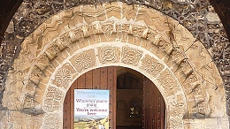
Be that as it may, the present parish church in Harmondsworth was constructed from the 12th century onwards, much of it before the 16th century. In the 18th century, a cupola was added to the bell tower. In the following century, repairs and restoration was undertaken. The south entrance has a decorated carved stone Norman archway. The carved capitals of the pillars on the south side of the nave are 12th century. The westernmost pillars on the north side of the nave are 13th century, whereas the four pillars to the east of these are 16th century. The chancel, which is supported by the newer pillars was constructed later than the nave. Where the newer part was joined to the older, there is a discontinuity in the stonework of the arch that joins the nave to the chancel: the two halves of the arch do not match each other. The pointed arches along the north side of the nave are Perpendicular gothic in style, whereas those north of the chancel are a Tudor design.
The tower of the flint covered church used to be the tallest building in Harmondsworth until the control tower at nearby Heathrow Airport was constructed, Douglas Dark mentioned of the church:
“Little did the early builders realise that their church was later to become the parish church of the manor where many visitors to Britain first arrive.”
A few yards northwest of the church, there is another treat awaiting visitors to Harmondsworth. This is the Harmondsworth Barn, which was constructed 1425-27 on land bought in 1391 by William of Wykeham (c 1320-1404), Bishop of Winchester, to endow Winchester College. It is now maintained by English Heritage, from whose website I gleaned the following information:
“Used mainly to store cereal crops before threshing, it remained in agricultural use until the 1970s. At 58 metres (192 ft) long and 11.4 metres (37 ft 6 in) wide, the barn is one of the largest ever known to have been built in the British Isles, and the largest intact medieval timber-framed barn in England.”
The barn’s main purpose was to store locally grown cereals (e.g., wheat, barley, and oats) and was still in use during the 1970s. Its interior is a fine example of well-preserved mediaeval carpentry. The barn is located on the eastern edge of what was once Manor Farm, through which a stream of the River Colne flowed. The erstwhile farm covered the probable site of a long-since demolished Benedictine Priory.
James Thorne noted that the barn had once been ‘L’ shaped, rather than rectangular as it is today. The part of it that had made it shaped like an ‘L’ was taken away and relocated elsewhere. To quote Thorne:
“This wing was taken down about the same time as the Manor House and rebuilt at Heath Row, 1 ½ miles S.E. of Harmondsworth church. This, which is known as the Tithe Barn, exactly resembles the Manor Barn in structure, except the walls are of brick…”
Well, ‘Heath Row’ is now ‘Heathrow’ and this fragment removed from the barn at Harmondsworth no longer exists. I located it on a map surveyed in 1862. It then stood on a road or lane that ran south from the Bath Road to Perry Oaks Farm on the western edge of Heathrow village. This land is now covered by the airport terminals (1,2, and 3).
Harmondsworth village has a few other old buildings apart from those already mentioned. One of them is Harmondsworth Hall, which Wendy Tibbits described in her blog (www.wendytibbitts.info) as follows:
“This grand-sounding building was built in the early 1700s, but still has elements of a fire-damaged Tudor building which was on this site. The central chimney and a fireplace are remnants of the former hous. … In 1910 this house was the first house in Harmondsworth to have its own electricity supply.”
Both Ms Tibbits and the vicar of the parish church fear for the future of Harmondsworth should plans to extend Heathrow Airport are carried out. Most of the old village will be demolished, leaving the church and the barn. Ms Tibbits noted:
“If the London Airport Expansion plans go ahead eleven listed buildings in Longford, and twelve in Harmondsworth will be demolished, along with hundreds of other homes. Only Harmondsworth medieval Great Barn and its Norman church will survive the destruction, but who will want to visit them when they will be meters from the airport’s perimeter fence?”
Although extending the airport might benefit the country, it would be sad to lose yet more of Britain’s heritage.
I VISITED BARCELONA in the late 1960s. One of the sights I saw was a museum dedicated to Pablo Picasso. Before entering that place, the artist’s works somewhat puzzled me. In the museum, there were some of Picasso’s earliest paintings. They were straightforward rather than abstract, and extremely well executed. The artist’s talents were immediately obvious. As I moved from room to room, the works on display became increasingly abstract. By seeing his progression from figurative to abstract, I began to appreciate his greatness as an artist, and I began to understand why he is regarded as a brilliant creator by many people. By the time I had finished looking around the museum, I had been converted from being sceptical about Picasso to becoming yet one more of his fans. More recently, I saw an exhibition showing the artistic development of Roy Lichtenstein from his earliest to his latest creations. No longer was he just a creator of entertaining pictures based on American comic strips, but I could see that he was an artist of great competence. Like the foregoing examples, a visit to the Cartwright Hall Museum in Bradford and seeing some of David Hockney’s earliest works also enhanced my appreciation of this highly prolific visual artist.
Bradford in Yorkshire is not far from the city of Wakefield, where Barbara Hepworth (1903-1975) was born. She was baptised in the city’s fine cathedral. Until today, I had mixed feelings about Hepworth’s works. There are some that I like very much, including a Mondrian-like crucifix at Salisbury Cathedral and a Naum Gabo inspired work attached to the eastern side of the John Lewis shop on London’s Oxford Street. Also, I have enjoyed visits to Hepworth’s studio and garden in Cornwall’s St Ives. However, as beautifully executed as her works are, I did not become terribly keen on her artistic output until today, the 18th of September 2021.
What converted me and increased my appreciation of Hepworth as an artist was today’s visit to the Hepworth Wakefield Museum. We arrived to discover that for the time being the whole museum is filled with works by Hepworth, beginning with her earliest and ending with her latest. The temporary exhibition, “Barbara Hepworth: Art & Life”, continues until the 27th of February 2022, and should not be missed.
As with other abstract artists, such as Picasso, Hepworth began learning the basics of figurative representation. Her earliest carvings and drawings were created superbly competently but give no hint of which directions her creative output was soon to follow. Had she not developed any further, she would have been regarded as a skilled, if not too exciting, sculptor. However, Hepworth soon became involved artistically, and in one case maritally, with leading artists of the twentieth century. Contact with them and their ideas can be detected in some of the works she created as she moved from purely representational to highly abstract. It was particularly interesting to see a small carving with a hole in it, the first of her many works to have holes in them. The idea of the holes is to allow light to flow through her sculptures. It was not only other artists who inspired Hepworth’s creation but also the forces of nature, which unconsciously sculpt rocks, trees, and other natural features in the landscape.
It was interesting to see the life-size prototypes of some of Hepworth’s works I have admired in the past. It was wonderful, for example, to be able to get close to the full-size model sculpture which is now high up on the wall of John Lewis in Oxford Street.
Once again, seeing a collection of works illustrating the progression of an artist’s output from student days until the achievement of fame and beyond has helped me to increase my appreciation of an artist about whom I had some reservations. Today’s visit to the Hepworth Wakefield has moved Barbara Hepworth a long way up my ladder of great artists and removed any doubts I had about her works.
Finally, here is something that intrigues me. Hepworth, like Picasso and also my late mother, had what might be described as traditional basic artistic training, just like the European and western artists who created during the many centuries before the 20th, yet all three of them (and many others) moved from expressing themselves with figurative works to abstract creations. However, unlike the artists who flourished before the latter parts of the 19th century and never strayed into the world of artistic abstraction, those who created during after the late 19th century (including the Impressionists) strayed away from the purely figurative/representational. Why this happened is no doubt the subject matter of much art historical literature, which I have yet to read. As I wrote the previous sentence, it occurred to me that the move towards abstraction (and other forms of art that do not appear to give the viewer a straightforward recreation of nature) coincided with the advent of photography. The photograph can give the illusion of being a true image of the world, leaving the artist to explore other more imaginative representations of what he or she has seen.
IT WAS ONLY WHEN WE left our accommodation at Dholavira and headed east onto the causeway which connects Khadir Bet to the rest of Kutch (part of Gujarat) that we saw a truly white part of the White Rann (desert). Until then, we had seen small patches of salt crystallising on the surface of what had once been the seabed, an inlet of the Arabian Sea, before seismic activity rendered the sea into a desert.
As we drove across the causeway, we passed larges patches of what looks like freshly fallen snow. This is the salt that has crystallized after the evaporation of rain, which has fallen on the salt laden terrain. The layer of salt looked to be at least an inch or two deep. What we saw is what gives the White Rann its name. It is a truly white desert. We were also fortunate to spot three flamingos searching in a pool of water that had not yet evaporated. They were silhouetted against the morning sunshine.
After crossing the causeway, we drove for several hours towards the outskirts of Bhuj. We stopped for refreshments at Rapar, which looks like an Indian version of a small town in an American cowboy film. A woman in colourful traditional garb disembarked from a motor scooter on which she had been travelling with her husband and son. A cow wandered past her before she crossed the road with her son. A stray dog took a great interest in various used packages I threw in a bin, and then ran off.
At another stop, I drank tea from a saucer as the locals do. By pouring the tea into a saucer, the surface area of the liquid increases and the drink cools quicker than if it is in a cup.
At Bhuj, we headed north on a road that eventually ends abruptly at India’s border with Pakistan. At first, we drove across part of the Great Rann of Kutch. This is a very flat sandy area with sparse scrubby vegetation but no trees. We passed herds of buffaloes grazing in this arid area. Unlike the White Rann, the Great Rann is mostly sand coloured although I did spot occasional salty patches that looked like very light ground frost. The Great Rann is classed as a desert but it is home to a few industrial plants.
Somewhere along the long straight road crossing the Great Rann heading northwards, we passed a sign indicating we had crossed the Tropic of Cancer.
At the tiny village of Bhirindiyara, famed for its fine mawa. This is milk boiled slowly for about four hours and then mixed with sugar. It is a sweet paste faintly resembling vanilla fudge or caramel…delicious but probably not too healthy!
We left the main road leading towards Pakistan and began climbing towards the Black Hills of Kutch. We reached a sign that announced that we had arrived at the “Magnetic Field Area”. Our driver explained that here thrre is a magnetic field strong enough to drag a car. To demonstrate this, he turned off the engine, leaving the gear in neutral. Amazingly, our car began moving uphill without the engine.
We continued on our way into the Black Hills of Kutch, driving through a moonlike, rocky landscape. We drove up a series hairpin bends to Kala Dungar, the highest place in Kutch, 458 metres above the Rann.
The road between Bhuj and the side road to Kala Dungar is the main route to the largest part of the White Rann, where the annual White Rann Utsav (festival) is held in January and February. A huge tent encampment is set up on the salt covered desert and a fairground atmosphere reigns. The Utsav attracts many tourists, both Indian and foreign.
It is interesting to contrast the road from Bhuj to the Utsav with that from Bhuj to Dholavira. The former is highly developed for the large influx of tourists. Unlike many other roads in Gujarat, the one leading to the Utsav has many signs in English and is lined with resorts designed to appeal to visitors. In contrast, the road from Bhuj to Dholavira is like a route into the back of beyond. Apart from a few low-key tourist oriented enterprises near Dholavira, the road from Bhuj to Dholavira makes no concessions to attract tourists. Dholavira, unlike other parts of the White Rann, feels far away from the rest of the world and its few inducements to get tourists to part with money seem charmingly naive. However, in a year or two this is likely to change.
The change will follow the completion of a new road from Bhuj to Dholavira. Unlike the existing road that passes through Bhachau and Rapar, the new road will pass close to Kala Dungar and cross the great Lake of Kutch to Dholavirs on a new causeway. This will shorten the journey time between Bhuj and Dholavira from its present four and a half hours to about an hour and a half. The present remoteness of Dholavira, which is part of its charm, will be lost forever. The area will become much more easily accessible to tourists, and no doubt this will be beneficial for the prosperity of the locals. From a selfish point of view I am pleased that I visited Dholavira before the greater influx of visitors that will surely follow the completion of the new road.
We arrived at our hotel in the bazaar in the old city centre of Bhuj after sunset. After a couple of days in rustic Dholavira and several days in the countryside near Mandvi, the small city of Bhuj seemed to us to feel like a large metropolis.
