WATER STORAGE TANKS and wells are subject to changes in the water level. In small wells such as are commonly found in England, a bucket and winch system allows the water gatherer to reach the water in the well. In India where water tanks and wells can be quite large, occupying a substantial area of ground, another system is used to allow users to get to whatever level the water has reached. The walls of the sides of the tank/reservoir/well are lined with a series of staircases, which are used to reach the water. Often the sets of steps lining the walls of the so-called stepwells are arranged in attractive geometric patterns.
At the Toorji stepwell
Since first seeing a (disused) beautiful stepwell in the ruins of the medieval city of Vijayanagara at Hampi in Karnataka thirty years ago, I have been fascinated by stepwells. I have seen many while travelling around Gujarat, and was pleased to find one near our guest house in Jodhpur (Rajasthan). It’s name is Toorji ka Jhalra Bavdi.
The Toorji stepwell was built in about 1740. Its construction was ordered by the Queen Consort of Maharaja Abhay Singh. Back in those days, ladies of the royal family often commissioned the building of water tanks and wells. The Toorji stepwell was used mostly by women, who traditionally did household chores including the fetching and carrying of water.
Toorji stepwell is constructed with the rose red sandstone of Jodhpur. It is decorated with carvings of various sizes. Nowadays, as with so many interesting places all over the world, it is a popular location for taking ‘selfies’ and for posing for photographs. Despite this, it is a stepwell worth seeing and is a remarkably tranquil spot surrounded by a maze of narrow, busy streets and lanes.
THE AVAILABILITY OF water is essential for human life. Since 8400 BC, or even earlier, mankind has been digging wells to access sources of groundwater. In England today, usable wells are few and far between because water is supplied by various other means. Occasionally, one comes across wellheads of now disused wells. One of these has become a minor visitors’ attraction on the lovely small island of Mersea, which is south of Colchester on the north side of the mouth of the Blackwater River.
The well head, which in in West Mersea and has been recently restored looks like a square wooden crate. It has a commemorative bronze plate on its square covering. Known as St Peter’s Well, it was an important source of water from ancient times until the early 20th century. It may have been associated for a while with a West Mersea Priory (founded 1046, dissolved 1542) that once stood nearby.
In April 1884, Mersea Island was struck by an earthquake. A crack in the ground opened near St Peters Well, and for a short time the water in it:
Today, there is little to see but the restored wooden wellhead that stands on a slope overlooking the wide sandy beach, which appears when the tide is out, The metal plate contains quotations from the Bible and the information that the well, which had served the people for over 1000 years, was one of the main sources of fresh water for the islanders, and had never run dry.
Judging from the contents of rubbish bins awaiting collection from the street entrances of houses in West Mersea, an important source of fluid intake is nowadays bottles and cans obtained from the booze shelves of off-licenses and supermarkets.
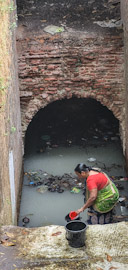
ACROSS THE MAIN ROAD from the 16th century Hazira Maqbara – a mausoleum – there is a small stepwell – the Hazira Vav. We have visited it before but never saw it in use.
A flight of tiled steps leads down to the water in the stepwell. To put it mildly, the water looks filthy and completely uninviting.
At the top of the stairs, there is a small Hindu shrine. The small courtyard surrounding the top of the staircase is decorated with coloured images depicting various Hindu deities. A few coconuts hang between them. These nuts are considered auspicious by Hindus. At our Hindu wedding in 1994, coconuts were included on the complex ceremony, which lasted several hours.
While we were looking at the well, a lady in a sari and her husband arrived. The woman descended the steps to the waters edge. Her husband explained to us that she was suffering from itchiness and that the curative waters of the well might help cure her condition.
The lady picked up one of the bucket on the step beside the water, and filled it from the well. Then, she began dowsing herself with the water. Fully dressed, she poured several buckets of the unwholesome looking water over her whole body.
Having watched this, we felt that it was unlikely that the water itself would heal her, but more likely, it was her faith in its curative properties that might have helped. Having seen the water, my thought was that if one bathed in the well, it is likely that you would end up less healthy than before you entered it.
LONG BEFORE LONDONERS began the current fashion of carrying bottle of water wherever they go, the city’s inhabitants had to rely on water sources such as hand-operated street pumps. Although there are still a few functioning public drinking fountains in London, there are no usable pumps to be found. However, a few of them have been kept as historic monuments. One of these is located on the north pavement of Cornhill, a few yards east of the Royal Exchange building.
The pump, which is now kept looking like new – except that it no longer works – was set-up in 1799. On one of its four sides, the manufacturers, Phillips & Hopwood (“Engine Makers”), have included the information that the pump was paid for by the Bank of England, the East India Company, Fire Offices (i.e., insurance companies), and the “bankers and traders of the Ward of Cornhill”. The inscription on this side of the pump also mentions that the it was erected above a well that had been discovered and enlarged.
On another side of the pump, that facing south, there is a brief history of the well. It was first dug before 1282 when Henry Wallis (aka Henry le Walleis; died 1302), thrice Mayor of London, built a “House of Correction” on the spot. This was a prison for “night walkers” and was known as “The Tun”. Stow writing his “Survey of London” in 1598, noted that the prison was built of stone and (preserving Stow’s spelling) we learn: “In the yeare 1298. certaine principall Citizens of London, brake vp this prison called the Tunne, and tooke out certain prisoners for the which they were sharply punished by long imprisonment, & great fines, as in another place I haue shewed. In the yeare 1401. this prison house called the Tunne was made a Cesterne for sweete water conueyed by pipes of Leade frõ the towne of Tyborne, and was from thence forth called the conduite vpon Cornhill: Conduite vpõ Cornhill.Then was the wall planked ouer, and a strong prison made of Timber, called a Cage, with a payre of stockes set vpon it, on the top of which Cage was placed a Pillory for the punishment of Bakers offending in the Assise of Breade: for Millers stealeing of Corne at the Mill: and for baudes Cage, stockes and pillorie vpon Cornhill.and scolds &c.”
By the time the pump was set-up, the prison had long since gone (? demolished). How and why the well was rediscovered, I cannot say, but it was, and its water became accessible by using the pump. The top of the pump serves as an advertisement. At the top of each of the four sides of the pump, there are symbols, which people would have recognised as being the trademarks of four insurance companies in existence at the time that it was established. Back in the 18th and early 19th centuries, firefighting services were provided by the insurance companies. The trademarks of insurance companies were placed on buildings so that firefighters of each insurance company could recognise which houses had paid for policies that made them eligible to be saved by the firemen.
Today, firefighting is no longer provided by insurance companies, and water is no longer available from public pumps. So, it is not surprising to see many people wandering around London with their own supplies of drinking water – in plastic bottles and other containers. What does surprise me is that when I was younger, in the 1960s and 1970s, one hardly ever saw people carrying their own drinking water. Now, it is quite common to see people sipping from their personal water carriers. Have people become thirstier recently, or what is it that makes them feel that they should never be without a portable supply of potable water?
THE NAME ‘TYBURN’ evokes thoughts of executions in many people’s minds. For, amongst the trees growing by the River Tyburn, there were many executions carried out in mediaeval and later times. Eventually, the place where these fatal punishments were performed was moved westwards to near where Marble Arch stands today. Amongst those who lost their lives, there were many unfortunate Roman Catholics, who were regarded as traitors because they wished to adhere to their religion. Today, the Tyburn Convent and Church stands at the eastern end of Bayswater close to the ‘Tyburn Tree’ the site of the executions (https://www.tyburnconvent.org.uk/tyburn-tree).
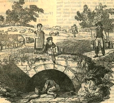
Shepherd’s Well, Hampstead; as it was during the early 19th century
The River Tyburn, now no longer visible, was one of several of the so-called ‘lost rivers’, tributaries of the River Thames that have been buried beneath the city of London. The Tyburn crossed what is now Oxford Street somewhere west of Marylebone Lane and east of Marble Arch, and then flowed southwards towards Green Park and then to the River Thames. Its exact course from Green Park to the Thames has been long forgotten because no reliable early map of the stream exists. It is also believed that the course of the river might have been altered several times.
According to Nicholas Barton in his informative “The Lost Rivers of London”, the Tyburn has or had one source at Shepherds Well in Hampstead and another in the grounds of the former Belsize Manor (on the present Haverstock Hill). Then it flowed south through Swiss Cottage towards the present Regents Park. There, it is carried in a pipe across the Regents Canal towards Marylebone Lane.
Various footpaths lead from the east side Fitzjohns Avenue that runs from Hampstead to Swiss Cottage. These paths bear the names Spring Path, Spring Walk, and Shepherd’s Path. They are all just north of Lyndhurst Road. Near the corner of Lyndhurst Road and Akenside Road, which runs south from it, there is a circular stone plaque bearing the words:
“For the good of the public this fountain is erected near to the site of an ancient conduit known as The Sheperd’s Well”
The drinking fountain, which was placed by the Metropolitan Drinking Fountain and Cattle Trough Association has been removed, leaving only the metal plate placed by the Association affixed to the pavement. The drinking fountain is said to have been near the conduit known as Shepherd’s Well, but I wondered where exactly was it located.
A glorious Victorian Gothic building called Old Conduit House stands between the site of the circular plaque and the corner of Lyndhurst Road and Lyndhurst Terrace (formerly known as ‘Windsor Terrace’). This building might possibly have been named in memory of the Shepherd’s Well water conduit. This house was built in about 1864 (https://historicengland.org.uk/listing/the-list/list-entry/1379406). A detailed map surveyed in 1866 marks the building and, more interestingly, a spot labelled ‘Conduit Wells’, which is in what was then open country a few yards west of Old Conduit House, near where Fitzjohns Avenue (not yet built in 1866) meets Lyndhurst Road.
Edward Walford writing in his “Old and New London” published in the 1880s reveals:
“Down till very recently, Hampstead was separated from Belsize Park, Kilburn, Portland Town etc. by a broad belt of meadows, known as Shepherds’ or Conduit Fields, across which ran a pleasant pathway sloping up to the south-western corner of the village, and terminating near Church Row.”
This pathway ran along the course of what has become Fitzjohns Avenue. Walford continued:
“On the eastern side of these fields is an old well or conduit, called the Shepherd’s Well, where visitors, in former times used to be supplied with a glass of the clearest and purest water. The spring served not only visitors but also the dwellers of Hampstead with water, and poor people used to fetch it and sell it by the bucket.”
From this description, it seems likely that what was marked on the 1866 map as ‘Conduit Wells’ was, in fact, the Shepherd’s Well. A map dated 1860 (www.theundergroundmap.com/article.html?id=3&zoom=13&annum=1860) shows ‘Shepherd’s Well’ in the same spot as the Conduit Wells on the 1866 map. Walford added that unlike other springs around Hampstead (e.g. The Chalybeate Well in Well Walk), the water of the Shepherd’s Well did not have a high mineral content. The probable location of the Shepherd’s Well is close to the Junction of Lyndhurst Road and Fitzjohns Avenue, probably a short distance south west of the end of Shepherd’s Path.
Having traced the probable location of one of the sources of the Tyburn, where it gained life in Hampstead, we can reflect that it was beside the elm trees that used to grow along its banks near Oxford Street that the lives of many people, both innocent and guilty, came to an end. That was before the site of execution was moved westwards to where Marble Arch stands today. The
IT WAS HUNGER that drew us to Lighthorne, a tiny rural village just over six miles south-east of the city of Warwick. Our aim was to eat lunch at the highly recommended Antelope Inn before visiting the magnificent Compton Verney House with its gardens that were designed by Lancelot (‘Capability’) Brown in the 18th century.
Lighthorne is an attractive village nestling in a steep sided basin. Some newer buildings have been built on the slopes above what was the heart of the old village. The etymology of the village’s name is uncertain. Close to the Fosse way (a road built by the Romans; it linked Exeter with Lincoln in an almost straight line), it was in existence in 1086 when the Domesday Book was compiled. Throughout the centuries, the village has been ‘in the hands’ of various noblemen and religious institutions. Time constraints did not permit us to visit the village’s Church of St Lawrence, whose construction began in the late 14th century, but we hope to see it on a subsequent visit.
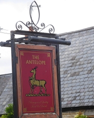
The Antelope Inn is housed in a building whose construction began in the early 18th century. The earliest record of the pub’s existence is a document dated 1838. This was signed by the then publican Joseph Lattimer. I was curious about the pub’s name because I thought that antelopes were not common in Warwickshire. The friendly staff in the inn suggested that there were two possible explanations for the name. One was that some previous owners of the pub had been a South African couple. Far more likely than this is the fact that the antelope is taken from the badge of the Warwickshire Regiment. A useful website, www.lighthornehistory.org.uk, explains the pub’s sign:
“The Antelope is standing on a strip of six pieces. This is said to be the six feet of turf representing the old name of the 6th Regiment of Foot.”
Always on the lookout for Indian connections, I found the following (www.forces-war-records.co.uk/units/316/royal-warwickshire-regiment):
“The Regiment took part in two campaigns in South Africa known as the Kaffir Wars (7th Kaffir War 1846-47 and 8th Kaffir War 1850-53), protecting Dutch and English settlers from the aggressive native tribes north of Cape Town. The Regiment also took part in the suppressing the India Rebellion of 1857.”
So, the regiment had taken part in campaigns both in South Africa, where my parents were born, and in India, where my wife was born. Regardless of the activities of the local regiment, we ate an excellent meal at The Antelope Inn.
More recently, in 1972, Ugandan Asians who had fled from Idi Amin’s Uganda were housed temporarily at Gaydon Airfield (now ‘Lighthorne Heath’) that is near Lighthorne (see: http://www.lighthornehistory.org.uk/wp-content/uploads/Shorthistory.pdf). Some of the inhabitants of Lighthorne assisted the distressed Asians during their first couple of months in England.
Almost opposite the inn, there is a well or spring that issues from an elaborate stone structure with a badly weathered coat-of-arms. It is a ‘broadwell’, a word derived from the Old English ‘breac-well’, a well that is supplied with water from a brook (rather than a spring). The well is likely to be as old as the village. However, the stone structure probably dates from 1746, as the Lighthorne history website notes:
“… the quoins and coving, were probably built in 1746, the remainder of the fascia, pool and paving are from the 19th and 20th centuries. The old ironstone escutcheon inserted in the fascia is older and is believed to be the arms of the Pope family, Lords of the Manor in the 16th and 17th centuries.”
There was green mildewed water in the two receptacles of the broadwell. It has been suggested that this well might have been used for washing in the past.
Close to the well, we spotted red grapes ripening on a vine growing on the side of a cottage facing the Antelope. They are located in what must be a fine sun trap. Our Sunday lunch in the inn, one of the best Sunday roast meals that I have eaten for many a year, ended soon before we were due to take up our timed entry at Compton Verney. Next time we visit the latter, spending more time in Lighthorne and The Antelope will be given top priority.