When nature challenges the flow of traffic.

THE ISLAND OF MERSEA is connected to the mainland of Essex by a causeway,  which was originally constructed before the medieval era. It is the only way that vehicles, motorised or otherwise,  can travel between Mersea and the rest of Essex.

Twice a day, the tide rises. When it does, not only do the mudflats close to the island become submerged beneath the sea but also the causeway.

The flooded causeway

After visiting East Mersey, we drove to the causeway and had to stop in a long queue of traffic. It was high tide, and the water had not only covered the causeway but also about 200 yards of the roadway approaching it. It was interesting to see how even in the 21st century,  a simple thing such as high tide can bring life to a standstill.

A small garden in London’s Lambeth next to a museum of gardens

THE GARDEN MUSEUM is next door to London’s Tudor Lambeth Palace and close to Lambeth Bridge. The museum has its own gardens – one within an enclosed courtyard, and the other, containing several glasshouses, outside the museum. Next to the latter, there is yet another garden, the St Mary’s Gardens. This slender garden, filled with a wonderful range of flowering plants, was created in 1932, and improved considerably in 2008.

In the centre of this almost rectangular garden there is a circular water feature, decorated with mosaics. This is surrounded by several smaller mosaics, each one depicting fruits and animals. From the northern end of the garden, you can catch glimpses of the Houses of Parliament and the towers associated with them.

Flanked by the busy Lambeth Road that leads to Lambeth Bridge, this garden is a pleasant oasis in one of the most traffic-infested parts of London.

An accident in a crowded street in Calcutta

SOME YEARS AGO (in 1997), we attended the first performance at London’s Nehru Centre (in Mayfair) of a work, “Samaveda Opus 2”, by the composer John Taverner (1944-2013). Taverner introduced the piece. During his introduction he repeated the sentence “India wounds me” several times. I have no idea what he meant by this, but the words have stuck in my mind. Until our latest visit to Calcutta (Kolkata), which was in January 2024, India has never wounded us. However, one morning, an unfortunate incident occurred, which I will now describe.

We (my wife Lopa and I) decided that we would revisit the 18th century Armenian church of St Bortola, which is in Bara Bazar in North Calcutta. Before leaving the Tollygunge Club, where we were staying, we found out from a website on the Internet that the church was supposed to be open. After enjoying good coffee at Blue Tokay in Bahrison’s bookshop on Park Street, we hailed a yellow and black Ambassador cab. The driver knew where we wanted to go and drove us through ever increasingly congested streets to Netaji Subhas Road in Bara Bazar. In this crowded street, the traffic was so bad that vehicles could barely move. As we were quite near to St Bortola, we disembarked, having decided to walk the rest of the way. As it happened, the narrow side streets along which we wended our way were so full of people that it would have been almost impossible for a taxi to go along them.

Busy bazaars always fascinate me. The streets in the part of Bara Bazaar near to the church were no exception. As we walked along them, we realised that we were in a district that was home to the shops and stores of merchants who sold chemicals in wholesale quantities. After negotiating the crowds in a couple of lanes, we spotted to spire of St Bortola, towering above the chaotic ensemble of buildings below it. We found the entrance to the compound containing the church. There were several men, including some security personnel, sitting in the porch. They all were very sure that visitors were not allowed to visit the church, nor even to photograph it. We protested that the website had claimed it would be open. We were told that if we wanted to view the church, we would first have to get special permission from the Armenian College (which is close to Park Street).

Having failed to gain access to the Armenian Church, we decided to visit the nearby Roman Catholic cathedral – The Cathedral of the Most Holy Rosary on Brabourne Road, almost opposite the Magen David Synagogue. Brabourne Road is one of the main thoroughfares carrying traffic to and from the Howrah Bridge, which crosses the Hooghly River. To say that this road as extremely busy is an understatement. Lined with stalls, the pavements are almost un-negotiable. So, pedestrians, including us walk along the edges of the roadway. People walk in both directions, often carrying heavy loads – usually on their heads. Added to this, many people seem to be in a great hurry and think nothing of rudely pushing aside fellow pedestrians. Meanwhile, buses, cars, wagons, rickshaws, heavy trucks, bicycles, motorbikes, and a variety of other wheeled vehicles rush past the pedestrians on the street. We experienced all this on a hot mid-morning.

We had to cross Brabourne Road to reach the cathedral. Fortunately, most of the traffic came to a stop briefly at a red traffic signal, and we joined a crowd of people swarming across the road. We began negotiating the crowds in an attempt to reach the cathedral. Then, it happened.

A wagon loaded with filled white sacks approached us. The sacks projected beyond the sides of the wagon. There were so many people walking along the side of the road that it was impossible for us to get out of the way of this heavily laden vehicle. Suddenly, one of the sacks hit Lopa’s shoulder, and she was sent flying. I was horrified. Luckily, she was thrown away from the road and her fall was cushioned by soft goods on the flimsy trestle tables of some pavement vendors. Although very shocked and extremely upset, she escaped major injury. Fortunately, her only injury was a small graze on her hand. She had had a lucky escape.

Much to my surprise, after a few minutes, Lopa decided we should walk the short distance to the cathedral. This we managed without any further unfortunate incidences. The compound – a peaceful garden in front of the west end of the church was open. However, when we reached the church, it was locked up. Someone sitting on the porch informed us that it was only opened once a week – on Sundays, and only for one mass.

By now, we had had our fill of Bara Bazaar. We hailed an Ambassador taxi to take us back to the Tollygunge Club. When Lopa related her unfortunate incident to the driver, he told us that Bara bazar is a bad area filled with ‘badmashs’ (i.e., bad or unprincipled people).

This unfortunate accident in Bara Bazaar was, as far as I can recall, the first time (in 30 years) that India wounded us. Having said that, I am sure it was not a physical injury that led John Taverner to say “India wounds me”.

Road reversal in central Calcutta

BETWEEN 8 AM AND 1 PM, traffic flows one way – from south east to northwest – along Calcutta’s Park Street. After 1 pm, traffic on this important thoroughfare flows one way but from northwest to southeast.

Park Street is one of several main roads in Calcutta on which the traffic flows in one direction until 1 pm,and then in the opposite direction from this time until 8am. It has long puzzled us as to what happens during the period when the direction reverses on these one way streets. Today, we discovered the answer.

The barrier was removed at 1257 pm

We were in a taxi at about 1250 pm, travelling east towards the start of Park Street. Some distance away from this point, there was a barrier preventing us and other vehicles from continuing towards Park Street. Our taxi and many other vehicles came to a halt at this barrier. Meanwhile, traffic coming towards us gradually diminished in volume to almost nothing.

At about 3 minutes to 1 pm, a traffic police officer slid away the barriers, and we began proceeding towards Park Street. Ours was one of the first cars to be travelling down Park Street from northwest to southeast.

Although I have visited many cities, it is only in Calcutta that I have seen this system of road reversal.

An artist and a traffic roundabout

THE FOLLWING FIVE ROADS meet at West London’s busy Hogarth Roundabout: The Great West Road, Church Street, Burlington Lane, Hogarth Lane, and Dorchester Grove. Excepting Church Street, they are all major thoroughfares, which carry a great deal of traffic. The roundabout is named after the artist William Hogarth (1697-1764), whose former home, Hogarth’s House – now a museum, is close by.

The museum at Hogarth’s House contains a large collection of prints created by Hogarth. All of them illustrate 18th century life in Britain in exceptional detail. The artist did not portray scenes straightforwardly. He portrayed the people and what they were doing in a satirical – sometimes comical – way. So, that what we see today is not only how things looked in Hogarth’s time but also what he felt about them.

Amongst the prints on display, there is one created in 1997 by the cartoonist Martin Rowson (born 1959). It depicts the chaos, dirt, and traffic at Hogarth Roundabout as Hogarth might have done had he been alive to see it. This entertaining print, which was made to commemorate Hogarth’s 300th birth anniversary, includes details copied from Hogarth’s prints. It is a fascinating addition to the collection of the small museum.

Catching a ‘plane in Kutch (Gujarat)

AIR TRAVELLERS CAN FLY to the former Kingdom of Kutch (Kachchh), now part of Gujarat, by two routes. There is a scheduled flight between Ahmedabad and Bhuj, and another between Mumbai and Kandla, whose airport is close to Anjar.

Kandla, was developed as a seaport on the early 1950s at the instigation of a member of the by then former royal family of Kutch. It lies on the coast of Kutch southeast of Karachi, a port that was incorporated into Pakistan in 1947, and northwest of Mumbai. It is now the largest port in India when measured by the volume of cargo handled there.

Cattle on the road

From Mandvi to Kandla Airport is 95 Km by road. We set off from Mandvi three hours before our flight to Mumbai was due to depart from Kandla. Our hosts, who use the airport frequently, told us that on average the road journey is 1 ½ hours. For the first hour of our journey, the highway was almost devoid of traffic. Along the way, we frequently switched lanes because heavy vehicles often move slowly along the outside lane without giving way to faster vehicles. We wove our way between slower vehicles, constantly overtaking and ‘undertaking’. Then after speeding along steadily, we headed towards a static queue of heavy lorries.

QuIck as a flash, our driver made a three point turn and we drove in the opposite direction tobthe rest of the traffic until we reached a gap in the central divider of the dual carriageway. We were not alone in making this manoeuvre. There were even some of the heavy goods vehicles making cumbersome manoeuvres to head away from the traffic jam. We continued our journey on the wrong side of the divider until we reached a turn off that allowed us to go under the highway and back into the correct lane.

Soon, we encountered another jam. A transporter carrying a tank as wide as one side of the motorway was inching its way onto the main road. Our driver took us off the road onto a dirt track, but this was also blocked. Another u-turn and we drove beneath the highway to a narrow, poorly tarmacced road that ran parallel to the highway. This led to a bridge beneath the main thoroughfare to reach another narrow lane that ran alongside the part of the highway running towards Kandla.

This lane offered other obstructions including large trucks and a herd of slow moving cattle. We squeezed past them and eventually rejoined the highway.

Meanwhile, the time was ticking away, and we wondered whether we would miss our flight. My spirits rose when we turned off the highway and on to a road leading to the airport. Soon, my hopes were dashed. We encountered yet another jam. However, our skilful driver managed weave his way between them. Soon, we arrived in front of the tiny airport terminal building.

Kandla Airport is primarily a military air base. Passengers use it for the one flight a day to and from Mumbai. When we disembarked there a few years ago, we walked from the aircraft to a shelter, where passengers’ check-in baggage was ready to be retrieved.

The check-in and security check is carried out in a part of a small room, the rest of which is part of the departure lounge (with a snacks stall). This hall leads to another room with seating. It is here that the departure gate is located. This simple departure lounge reminded me of Venice’s Marco Polo Airport as it was in the early 1960s.

We boarded the Spicejet two engined propellor plane after walking across the apron. The aircraft (a Q400 made by the Bombadier Company) has its own retractable staircase that we used to enter and later leave the ‘plane. After an uneventful flight lasting 1 hour and 15 minutes, we disembarked at Mumbai.

We were lucky only to have arrived a few minutes later than the scheduled time. Only three days earlier, my wife’ cousin’s flight from Mumbai to Kandla was delayed by almost 5 hours because of a technical problem discovered on the ‘plane minutes before it was due to take off. We were also fortunate because our quick-witted driver skilfully reduced the time spent stuck at significantly awful traffic jams.

Once it crossed the River Mersey, but now it has gone

WIDNES IN CHESHIRE is across the River Mersey from the town of Runcorn. In the past, both places were important industrial centres. Currently, they are linked by two impressive road bridges (the Mersey Gateway, opened in 2017; and the Silver Jubilee Bridge, opened in 1961 and given its present name in 1977) and a Victorian railway viaduct. The Silver Jubilee Bridge (‘SJB’) begins cross in the Mersey from Widnes near to St Mary’s church and the Victoria Gardens.

A few feet downstream from the SJB, there is what looks like a short jetty projecting a little way over the Mersey. On one side of this, there a small building with two separate slate roofs. The wide jetty-like structure looks disused. And so, it is. The structure is all that remains on the Widnes riverbank of the Widnes–Runcorn Transporter Bridge. Until 1905, when it was constructed, the only bridge across the Mersey at Widnes was the railway bridge (variously named as The Runcorn Railway Bridge, Ethelfleda Bridge, and Britannia Bridge), which was opened in 1868.

Between 1901 and 1905, when it was opened, the transporter bridge was under construction. It was the first of its kind in Britain. At each end of the bridge there was a 180 feet high steel tower. Suspended from them and spanning the length between them was a 1000-foot-long girder along which ran a continuous loop of cable. A transporter car was attached to the cable. The loop of cable was wound around a wheel attached to a winch on an engine housed in a building: the one which can be seen on the jetty-like structure at Widnes. As the wheel rotated, the cable moved, and the car attached to it moved across the river and high above it. The crossing took about 2 ½ minutes in favourable weather.

When it was built, the transporter bridge was cheaper to construct than a conventional bridge such as the one that replaced it in 1961 (i.e., the SJB). The transporter bridge, which was deemed inadequate for modern traffic volumes, was closed on the day that the SJB was opened, and it was demolished soon after. All that remains in Widnes is what can be seen at the end of Mersey Road next to the start of the SJB and Victoria Gardens. Although we did not visit Runcorn, I have read that the approach to the transporter bridge can be seen on that side of the river.

When we came across the remains of the transporter bridge, we had no idea what we were looking at. We asked several young people nearby, and they were unsure of its purpose. Older people whom we met in the nearby friendly pub (The Mersey), whose garden provides not only a pleasant place to drink but also a fine view of the SJB and the railway viaduct, were able to inform us about the bridge which is no more.

A bridge in London waiting for repairs

In the middle years of the 1720s, Daniel Defoe described Hammersmith as a village that was growing into a small town:

“… and some talk also of building a fine stone bridge over the Thames …”

It was almost 100 years after Defoe speculated that a bridge across the Thames would be built at Hammersmith. A suspension bridge was constructed between 1824 and 1827. It was the first of this type of bridge to be constructed anywhere near London and the first to span the Thames. James Thorne, writing in 1876, that in outline and simplicity of style, it:

“… remains the best-looking-bridge of its kind on the Thames …”

The bridge was designed by William Tierney Clark (1783-1852), who had been guided in his development of bridge construction techniques by Thomas Telford and John Rennie, who designed the old London Bridge that now stands in Lake Havasu City in Arizona. Clark also designed the suspension bridge (1832) across the Thames at Marlow and the impressive Széchenyi (Chain) Bridge which crosses the River Danube to link Buda and Pest. The latter resembles Clark’s Hammersmith Bridge as depicted in old engravings.

In 1883-37, Clark’s Hammersmith Bridge was replaced by a newer one designed by Joseph Bazalgette (1819-1891). According to Cherry and Pevsner in The Buildings of England. London 2: South, Bazalgette:

“… re-used the piers and abutments. Iron-framed towers clad in cast iron partly gilt, with Frenchy pavilion tops, and elephantine ornament at the approaches … The deck stiffening girders were replaced in a major overhaul in 1973-6.”

This bridge, which was built for use by horses and carts, pedestrians, and the occasional cyclist, long before the advent of heavy motor vehicles such as busses and lorries. It has been closed for repairs several times, causing much nuisance for those who live on both sides of it. In April 2019, Hammersmith and Fulham Council closed the bridge to all motorised traffic. This was done following the discovery of serious cracks in the pedestals that support the bridge. It remained open for pedestrians and cyclists until August 2020, when a heatwave caused further deterioration. Then, the bridge was closed to all users.  

A variety of schemes have been proposed for repairing the bridge and there was some disagreement as to who would pay for the work. In June 2021, Hammersmith and Fulham Council came to a cost-sharing deal to complete the rehabilitation of the Victorian bridge. In July 2021, the bridge was reopened for use by cyclists and pedestrians until 2027. In February 2022, I stepped on the bridge for the first time since it closed. The view from it is marvellous, especially upstream where one gets a good view of the historic buildings lining the waterfront between Hammersmith and Chiswick.

Churchill owned this village

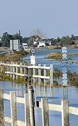
YOU CAN NEVER PREDICT how much traffic you will encounter on the roads in and near London. So, we always allow extra time when making a trip, and often we arrive earlier than we had planned. Such was the case yesterday when we had arranged to meet some friends for a walk in Heartwood Forest, which is close to the village of Sandridge in Hertfordshire. We reached our destination about an hour too early and stopped in Sandridge to get a warm drink and to take a look around. What little remains of old Sandridge is attractive and is worth a visit despite its description in “Hertfordshire, a Shell Guide” by RM Healey:

“Subtopian clutter in a village that has ribboned out to join St Albans.”

We bought coffee in the well-stocked small village shop and heard its owner saying:

“I am still in business despite being surrounded by three Tesco Express supermarkets.”

Now, here is a strange coincidence. After dinner, when I had finally warmed up after our excessively chilled walk in Heartwood Forest, I settled down to continue reading the wonderful biography of John Churchill (1650-1722), the First Duke of Marlborough, by Richard Holmes, and read on page 110:

“On 14 May that year John Churchill was created Baron Churchill of Sandridge in Hertfordshire …”

The year was 1685. Well, I was staggered to read the name of the village, of whose existence I had not previously been aware and which we had just visited by chance earlier that day. I reached for my Shell Guide to Hertfordshire but found no mention of Churchill in the section about Sandridge. Somewhat surprised by this omission, I looked up ‘Sandridge’ in James Thorne’s “Handbook to The Environs of London”, published in 1876. Thorne revealed something about Churchill’s connection with Sandridge.

The manor of Sandridge was given to Sir Ralph Rowlett (before 1513-1571; see: http://www.historyofparliamentonline.org/volume/1509-1558/member/rowlett-sir-ralph-1513-71) of Holywell House (St Albans, Hertfordshire), Member of Parliament for Hertfordshire and Master of the Mint of England (in1543), by Henry VII in 1540.  When Sir Ralph, who had no heirs, died, it was passed on to his sister Elizabeth, the wife of Ralph Jennings (aka ‘Jenyns’; 1529-1572; http://www.wikitree.com/wiki/Jenyns-10). Sir Ralph died in Churchill, Somerset. The Jennings family kept the manor for several generations. When Richard Jennings (c1619-1668) died, he left the manor to his three daughters, Barbara, Frances, and Sarah (1660-1744; the youngest). Sarah was probably born in Water End House, which was built by her grandfather John Jennings (Jenyns) and which I have described elsewhere (https://adam-yamey-writes.com/2020/07/23/why-go-abroad/).

In 1677 or ’78, John Churchill, then a colonel, married Richard’s daughter Sarah Jennings. Then, he purchased the other sisters’ shares in the manor of Sandridge so that he owned the whole property. This permitted him to gain his first aristocratic title, that of ‘Baron Churchill of Sandridge’. As a baron, he was able to sit in the House of Lords. However, his attempt to become an MP for his borough, St Albans, met with failure:

“Churchill acquired one moiety of the Jennings estate by marriage … He thus enjoyed the principal interest at St. Albans, and in 1685 the mayor announced his candidature for the borough. In the event, however, his brother George was elected, perhaps because James II had made known his intention to give him an English peerage.” (https://www.historyofparliamentonline.org/volume/1660-1690/member/churchill-john-ii-1650-1722).

On reflection, it seems a bit strange that we did not notice any obvious indication in Sandridge of the connection of the celebrated John Churchill, ancestor of Sir Winston Churchill, with the village in the manor he acquired.  Some months earlier we had visited the village of East Knoyle (in Wiltshire), where the architect Christopher Wren was born in 1632. Despite the fact that Christopher left the village with his family when he was only three years old, visitors to East Knoyle are left in no doubt about its famous connection.

What remains of old Sandridge is attractive, even in the appalling weather conditions that we endured whilst walking around it. The village’s name is derived from ‘Saundruage’ meaning a place of sandy soil worked by bond tenants (i.e., feudal tenants completely subject to a lord or manor to whom they paid dues and services in return for land). The earliest written record of the place is in a document dated 796 AD.

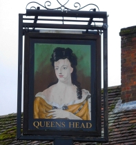
The most fascinating building in the village is the Church of St Leonards. Although its exterior looks in great condition, it contains some structural elements that were put in place in the 10th century. These include Roman bricks found at sites near and in St Albans (Roman ‘Verulamium’). The church was consecrated as ‘St Leonards’ by 1119. Later, the church experienced modifications and enlargements.  Sadly, but predictably during this time of pandemic, the church was locked. So, we will have to make another visit to see this interesting building when things ease up. Likewise, the picturesque Queen’s Head pub next to the church was also closed, except for take-away meals.

The Queens Head was built in the 17th century and, maybe, earlier, but has had much later work done to it (https://historicengland.org.uk/listing/the-list/list-entry/1102874).  The pub sign has the portrait of a woman’s head. The lady depicted has long black hair and is wearing a garment that exposes her neck and upper chest but not her cleavage. One long ringlet of her hair, which ends in a helical coil, is draped over the front of her left shoulder, and her face is looking slightly towards her right. The portrayal on the pub sign resembles that of Queen Anne (reigned 1702-1714) found in many better painted pictures.  This might not be accidental on a pub that existed long before Anne was on the throne. For, Lady Sarah Churchill, John’s wife, was a court favourite of Queen Anne. Incidentally, it is one of three pubs in this tiny village.

Once again, a short stop in a small English village has been most rewarding both from the aesthetic viewpoint and also because it has caused me to learn yet more detail about the fascinating history of the country where I live. I am grateful to our friends in Hatfield for giving us an excuse to discover Sandridge, a place so close to London but until yesterday, not on our ‘radar’.