The oyster merchant’s clock tower

BURNHAM-ON-CROUCH in Essex is a picturesque port on the River Crouch. Currently, it is a leisure resort and a centre for ship maintenance and boating. It was once famed for what grew in great numbers on the muddy bed under the water of the Crouch: oysters. For several centuries before the river became polluted in the 19th century, the oyster beds in the Crouch (and a few other places in Essex) were very profitable, providing much employment.  

“On the shores of England the principal nurseries of oysters, not only for the English markets, but also for the foreign, are those on the coast of Essex and the estuaries adjoining: those taken there are called ‘ Natives/ Mr. Sweeting claims the name as peculiarly applicable to his fishery, as within his memory no strange oysters have ever been introduced…”

Men were required both to dredge the oyster beds and process the molluscs as well as to protect the precious creatures from thieves based in other places on the Essex coast.

Today (11th of July 2022), we visited the small but excellent museum in Burnham-on-Crouch. On the ground floor, we saw a retired mechanised oyster grading machine (made in France and capable of sorting 7000 oysters per hour) amongst the exhibits. On the upper floor of the museum, which is housed in a former boat repair building, we met the museum’s treasurer, who is a mine of interesting local history. He told us several things about Burnham’s oyster heydays. I hope that what I am about to tell you is a reasonably accurate summary of what he told us. If it is not totally accurate, I hope that he and you, dear reader, will forgive me.

For 10 years, I used to live in north Kent and often visited Whitstable to enjoy eating oysters for which this Kentish seaport is famous. The treasurer in Burnham told us that many of what are described as ‘Whitstable oysters’ were born in the mud beneath the river in Burnham-on-Crouch. From what I can recall, the young oysters, which grow in the mud beneath the Crouch, are dredged and then placed on boards to which they attach themselves. Keeping them submerged in seawater, the boards to which the young oysters are attached, were transported to Whitstable where they matured in its waters. The Burnham oysters were ‘native’, meaning that they began their lives there; they were not imported, as Thomas Campbell Eyton described in “A history of the oyster and the oyster fisheries” (published in 1858):

“On the shores of England the principal nurseries of oysters, not only for the English markets, but also for the foreign, are those on the coast of Essex and the estuaries adjoining: those taken there are called ‘Natives’. Mr. Sweeting claims the name as peculiarly applicable to his fishery, as within his memory no strange oysters have ever been introduced.”

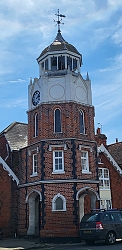
One of the exhibits in the museum is a large model of the octagonal Victorian clock tower that dominates Burnham-on-Crouch’s High Street. The tower stands next to the building that used to house the former St Mary’s School. It was erected in 1877 to honour the local philanthropist Laban Sweeting (1793-1876). So, what, you might ask, and what has he got to with what I have been writing about?

Laban Sweeting, mentioned in the quoted from Eyton’s book, was a philanthropist; a member of The Burnham River Company; and he was one of the town’s oyster merchants. The museum has amongst its exhibits a small barrow, which used to be wheeled around Burnham by a member of the Sweeting family. It would have carried baskets of oysters ready for sale to the town’s populace.

We had visited Burnham once before, and although I was impressed by the clock tower, I knew nothing of its history. Neither did I know about the town’s association with oysters, which were poor people’s food in the 19th century, when chicken was a luxury. How times have changed.

My uncle and the USSR

THE MARXIST SOCIETY of the University of East Anglia had just held a meeting around it, so we were told by someone working in the Sainsbury Centre for Visual Arts on the university campus in Norwich. The object around which the political gathering was held is a 35 feet high model of a structure that was never built full size. The Russian architect Vladimir Tatlin (1885-1953) had planned to build a futuristic tower in Petrograd (aka ‘Leningrad’ and ‘St Petersburgh’), an example of Constructivism. The tower, which was to have been 1300 feet high, was planned to celebrate and house The Comintern (3rd International). Hoping to rival Paris’s Eiffel Tower and to symbolise the modernity of Soviet Russia, the tower was never built.

Model of Tatlin’s tower with the Sainsbury Centre behind it

Sometime, back in the early 1970s, it was decided to construct a model of the Tatlin Tower near the Hayward Gallery on London’s South Bank. This was not a simple task because the structure is complex, and proper detailed blueprints were unavailable. To make a model of the Tatlin Tower that was faithful to the designer’s original idea, and which would not topple over, the services of a structural engineer were required.  My uncle Sven, who worked for the firm of Felix Samuely and Partners, proved to be the man for the job. Working with the project’s director, Jeremy Dixon, my uncle had to unravel the plans of the structure using photographs of a 17-foot model of the tower that Tatlin had created in 1920 and a few existing images of plans that Tatlin had prepared. There were inconsistencies between Tatlin’s plans and the model produced in 1920. In 1971, Dixon:

“…built small models in balsawood to get it right, and he worked with Sven Rindl of consulting engineer Felix J Samuely & Partners, who generated detailed freehand drawings as they talked” (quoted from “Blueprint”, December 2011)

Dixon wrote about this in Sven’s obituary as follows:

“I particularly remember working with him on the reconstruction of the remarkable tower that Vladimir Tatlin produced as a monument to the Third International, the communist organisation founded in 1919, for the Art in Revolution exhibition at the Hayward Gallery in 1971. The project required us to go back to first principles to reinvent its extraordinary geometry and structure.

Sven would sit listening and commenting during our complex voyage of discovery, and at the same time he would be drawing. These drawings would be remarkable, elegant, three-dimensional sketches straight off the sketch pad, finished and complete. They were graphic works of art as well as documentation of engineering ideas.”

(https://www.theguardian.com/news/2007/apr/30/obituaries.mainsection)

The model was built with timber inside the Hayward Gallery before being exhibited outside it in 1971 as part of an exhibition called “Art in Revolution: Soviet Art and Design since 1917”.

Forty years later in 2011, another model of the Tatlin Tower was produced, this time made of a more durable material, steel. Once again, the project was overseen by Jeremy Dixon. The completed model was first displayed in the courtyard of London’s Royal Academy. In an advance notice of the project (www.architectsjournal.co.uk/archive/ra-unveils-tatlins-tower), my uncle, who had died in 2007, was given a prominent mention:

“The 10.5m high steel structure in the Annenberg Courtyard was designed by architects Jeremy Dixon of Dixon Jones Architects, Christopher Cross, Christopher Woodward and engineer Sven Rindl. The tower will form part of the Royal Academy’s forthcoming exhibition, Building the Revolution: Soviet Art and Architecture 1915-1935 which opens on 29 October 2011.”

I remember going to view the model and then seeing a small exhibition about it and its construction. The exhibition, which was held inside the Royal Academy, included images of some of the beautifully drawn plans and diagrams created by my uncle.

The steel model of the Tatlin Tower, which was exhibited at the Royal Academy in 2011, has been lent to the Sainsbury Centre by the academy. Painted in red, this model of an experiment in futuristic architecture stands outside and close to the magnificent building that houses the Centre. The edifice, which is now over 40 years old, but looks like new, was designed by the architects Norman Foster and Wendy Cheesman.

We had no idea that there was a model of Tatlin’s tower next to the Sainsbury Centre when we visited it in September 2021. My wife and I were pleased to see this reminder of a much-missed relative whom we both loved dearly.

A short note about a round tower

MANY CHURCHES IN NORFOLK have circular towers. Actually, there are 124 of them in the county. Here is one example, St Mary’s in tiny Titchwell, near the north Norfolk coast. The small spire that tops the round tower dates to the 14th century. The foundation of this church was much earlier.

By the way, the name ‘Titchwell’ is derived from an Old English word meaning ‘ kid (young goat)’ and an Anglian word meaning ‘spring or well’.

Story of a tower

“IT’S THE TOWN’S SYMBOL, you see”, we were told by a friendly young man whom we met by chance in a churchyard in the town of Bruton in the county of Somerset.

“Never been up there myself, even though I’ve been living in Bruton all my life,” he told us, pointing at a tall tower on the summit of a hill overlooking the town.

“Where have you come from?” he asked us. When we replied ‘London’, he commented:

“Never been there myself. Have a good evening.”

Bruton is about 120 miles southwest of central London. The tower about which we had asked the young man is square in plan, is built of neatly cut limestone blocks, has three layers of windows, and looks (from below) as if it is missing its roof. The top parts of each of the four walls are triangular, looking as if they were once the side walls of gabled roofs.

The tower that stands in Bruton’s Jubilee Park is known as ‘The Dovecote’. The hill on which it stands rises steeply from the almost level fields of the public park. Birds, mainly pigeons, could be seen perching on the edges of the four gables at the top of the tower. It stands on a square plot 65 square feet in area and is situated on land over 300 feet above sea level, to the south of the centre of Bruton. Although it is tall, I have not been able to discover its height by searching the internet. That it has lost its roof, is recorded.

The tower stands in what was a deer park of about 30 acres established in about 1545-6 by the canons of the long-since demolished nearby Bruton Abbey (whose remains can be seen in the town). The park was later enlarged and surrounded by a wall. In the 18th century, the deer were removed. However, much earlier, in the 16th or, 17th century (actual date is uncertain although some of the timber used in the construction has been dated as being felled between 1554 and 1586), the present tower was built by the Berkly family. They acquired the land after the Dissolution of the Monasteries by Henry VIII. The tower was built to be used as a ‘prospect’ or ‘look out’ tower.

In about 1780, or maybe much earlier, the tower was converted to be used as a dovecote. Inside the tower, which we could not enter, there are roosting spaces (nesting boxes) for at least 200 doves. Long ago, pigeons and doves were an important food source. They were reared for their eggs, flesh, and dung. In 1915, the National Trust (‘NT’) acquired the freehold of the tower from Sir Henry Hugh Arthur Hoare (1865-1947). Not only did Sir Henry give his tower to the NT, but also, more importantly, he also donated his family estate with its fabulous landscaped grounds at nearby Stourhead to the same organization in 1946. The Hoare family, about whom I hope to write soon, is also associated with another tower not far from Bruton, the Alfred Tower, which we have visited … but more on this anon.

Although we could not enter The Dovecote tower, we did one better than the young local with whom we spoke earlier; we walked up to its base.

All that remains is …

OUR GOOD FRIENDS IN HERTFORDSHIRE always take us out into the countryside for a walk with their two friendly dogs. Invariably, we visit countryside that is both beautiful and contains something of interest. This time, we parked in the small hamlet of Thundridge (in Hertfordshire), which is located on what was once the Roman road, Ermine Street (from the Old English ‘Earninga Straete’). This thoroughfare linked London with York. We set off by walking along a small road named Old Church Lane. This soon becomes a footpath that runs alongside the River Rib, a tributary of the River Lea, which in turn is a tributary of the River Thames. The Rib merges with the Lea in the town of Hertford.

We walked past a vast field in which some grassy crop was growing. Far across the field there was a small wood. A church tower could be seen rising from amongst the trees. We followed another path towards the clump of trees and soon arrived at the tower. This tower and a graveyard is all that remains of the church of St Mary and All Saints (some call it ‘All Hallows and Little St. Mary’ and others ‘Thundridge Old Church’), which was demolished (apart from the tower) in 1853, when a new church was built in Wadesmill. The tower was constructed of flint and mortar in the 15th century. The rest of the church, now demolished, was built in the 11th to 12th centuries. A Romanesque archway now set into the eastern wall of the tower is the only visible remains of that former church.  Although this ruined tower might well appeal to those who find ruins romantic, it is in a bad condition with some of the structure covered with corrugated iron sheeting and other parts with graffiti. There are some plans to conserve it and others to demolish it to make room for new housing.

The reason that the old church was demolished was that the old manor house, which was close to the old church, was demolished in the 19th century. Consequently, the population of Thundridge moved nearer to the new manor house that was built where the church built in 1853 now stands.

Just before we reached the old church tower, we passed a field which had a long grass-covered trench running along it. This is the remains of a moat built long ago when Thundridge village was located near to the the old, now demolished church. The banks of the moat were liberally studded with mole hills. This moat is believed to have been dug in mediaeval times. What remains of it is ‘D’ shaped and encloses an area bounded by sides of approximately 660 feet north to south and by the same east to west. The moat enclosed the site of the former manor house.

Having seen all that remains of Thudridge Old Church, we retraced our steps to Ermine Street, crossed the fast-flowing River Rib, and then ate an enormous roast lunch in the garden of the nearby Feathers pub in Wadesmill, which is about two minutes’ walk from Thundridge.